Overview
A cold front approached the area later in the day on May 7th. A line of thunderstorms developed ahead of it in central Illinois down to near St. Louis during the afternoon hours. This line of storms then proceeded east/southeast along the I-64 corridor through the early evening hours. Damaging winds were the main impact from this bowing line of storms. There was one confirmed tornado that touched in Pike County, IN east of Petersburg.Tornadoes:
|
|
||||||||||
|
||||||||||
|
Tornado - Near Otwell, IN
Track Map  
|
||||||||||||||||
The Enhanced Fujita (EF) Scale classifies tornadoes into the following categories:
| EF0 Weak 65-85 mph |
EF1 Moderate 86-110 mph |
EF2 Significant 111-135 mph |
EF3 Severe 136-165 mph |
EF4 Extreme 166-200 mph |
EF5 Catastrophic 200+ mph |
 |
|||||
Radar:
Click here for a radar loop of this event
The above link shows a radar animation from 4 PM until 10 PM. The bowing line of storms affected areas along the I-64 corridor in southern IL, southwest IN, and far northwest KY.
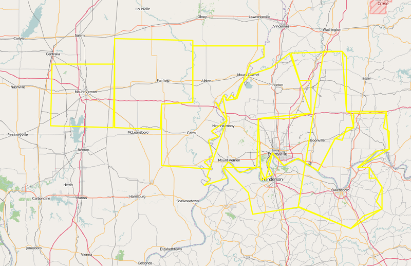
The graphic below shows the polygons for all of the severe thunderstorm warnings issued, overlayed on top of each other.
Storm Reports
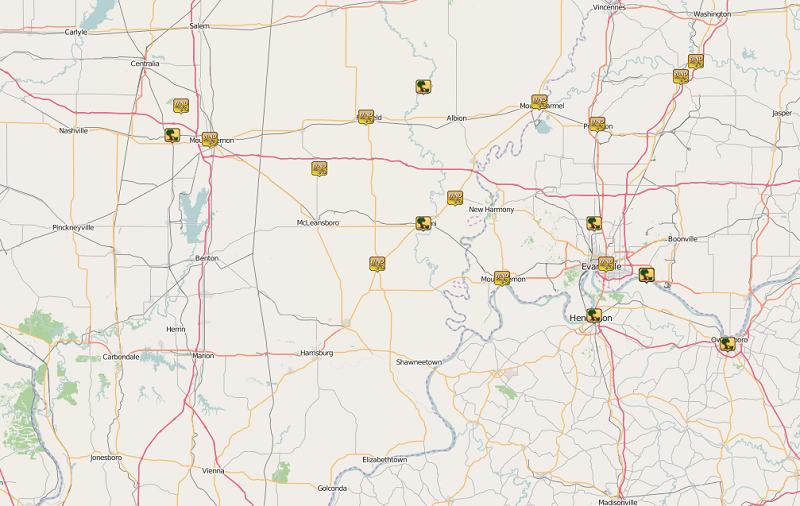
..TIME...   ...EVENT...      ...CITY LOCATION...     ...LAT.LON...
..DATE...   ....MAG....      ..COUNTY LOCATION..ST.. ...SOURCE....
            ..REMARKS..

0543 PM     TSTM WND GST     BOYD                    38.41N 89.01W
05/07/2016  E75.00 MPH       JEFFERSON          IL   TRAINED SPOTTER

            REPORTED BY TRAINED SPOTTER. WINDS ESTIMATED.

0550 PM     TSTM WND DMG     WOODLAWN                38.33N 89.04W
05/07/2016                   JEFFERSON          IL   LAW ENFORCEMENT

            LARGE TREE LIMB DOWN ACROSS A POWER LINE

0555 PM     TSTM WND GST     MOUNT VERNON            38.32N 88.91W
05/07/2016  M52.00 MPH       JEFFERSON          IL   AWOS

0615 PM     TSTM WND GST     FAIRFIELD               38.38N 88.37W
05/07/2016  M46.00 MPH       WAYNE              IL   AWOS

0617 PM     TSTM WND GST     2 NE BELLE PRAIRIE CITY 38.24N 88.53W
05/07/2016  M61.00 MPH       HAMILTON           IL   TRAINED SPOTTER

0636 PM     TSTM WND GST     NORRIS CITY             37.98N 88.33W
05/07/2016  E60.00 MPH       WHITE              IL   TRAINED SPOTTER

            WINDS ESTIMATED GREATER THAN 60 MPH, RELAYED THROUGH EM
            SCANNER.

0640 PM     TSTM WND GST     CROSSVILLE              38.16N 88.06W
05/07/2016  E65.00 MPH       WHITE              IL   TRAINED SPOTTER

            WINDS ESTIMATED 60 TO 65 MPH.

0640 PM     TSTM WND DMG     CARMI                   38.09N 88.17W
05/07/2016                   WHITE              IL   TRAINED SPOTTER

            TIME ESTIMATED. SNAPPED TREES AND POWER POLES REPORTED IN
            THE COMMUNITY.

0645 PM     TSTM WND DMG     5 SE MOUNT ERIE         38.46N 88.17W
05/07/2016                   WAYNE              IL   TRAINED SPOTTER

            LATE REPORT. LARGE TREE LIMBS AND BRANCHES DOWN. HEAVY
            RAINFALL REPORTED WITH THIS STORM.

0654 PM     TSTM WND DMG     MOUNT CARMEL            38.42N 87.77W
05/07/2016                   WABASH             IL   EMERGENCY MNGR

            ROOF BLOWN OFF OF THE MIDDLE SCHOOL. PORTIONS OF THE
            COUMMUNITY WITHOUT POWER. NUMEROUS TREES AND POWER LINES
            DOWN THROUGHOUT THE COMMUNITY.

0657 PM     TSTM WND GST     MOUNT CARMEL            38.42N 87.77W
05/07/2016  M66.00 MPH       WABASH             IL   AWOS

0658 PM     TSTM WND GST     PRINCETON               38.36N 87.57W
05/07/2016  E60.00 MPH       GIBSON             IN   TRAINED SPOTTER

            WIND GUST ESTIMATED 55 TO 60 MPH.

0712 PM     TSTM WND GST     EVANSVILLE              37.98N 87.54W
05/07/2016  E60.00 MPH       VANDERBURGH        IN   TRAINED SPOTTER

            WINDS ESTIMATED. REPORT FROM THE OAK HILL SUBDIVISION.

0719 PM     TSTM WND DMG     HENDERSON               37.84N 87.58W
05/07/2016                   HENDERSON          KY   AMATEUR RADIO

            TREE AND POWER POLES DOWN ALONG CENTER STREET.

0721 PM     TSTM WND GST     NEWBURGH                37.95N 87.40W
05/07/2016  E70.00 MPH       WARRICK            IN   TRAINED SPOTTER

            WINDS ESTIMATED 65 TO 70 MPH REPORTED.

0725 PM     TSTM WND GST     4 NE PETERSBURG         38.53N 87.23W
05/07/2016  M62.00 MPH       PIKE               IN   TRAINED SPOTTER

            MEASURED WIND. TREES AND BRANCHES DOWN AND LAYING ACROSS
            ROADWAY AND NEARBY RAINROAD TRACK.

0728 PM     TSTM WND DMG     NEWBURGH                37.95N 87.40W
05/07/2016                   WARRICK            IN   TRAINED SPOTTER

            RV TYPE CARPORT BLOWN OVER.

0736 PM     TSTM WND DMG     OWENSBORO               37.76N 87.12W
05/07/2016                   DAVIESS            KY   CO-OP OBSERVER

            LATE REPORT OF TREE DOWN.

0739 PM     TSTM WND GST     PETERSBURG              38.49N 87.28W
05/07/2016  M62.00 MPH       PIKE               IN   TRAINED SPOTTER

            MEASURED WIND. NUMEROUS TREES DOWN ALONG ROADWAYS.
 |
Media use of NWS Web News Stories is encouraged! Please acknowledge the NWS as the source of any news information accessed from this site. |
|

