Overview
Multiple rounds of severe thunderstorms impacted the region on May 26th producing widespread damage, leaving over 100,000 customers without power at its peak. The first wave was a bowing line that progressed east across southeast Missouri into western Kentucky and far southern Illinois between 5 and 10 AM. This was quickly followed by a second line that was mostly sub-severe which then exited our region by 1 PM. The environment was able to recover during the afternoon, providing ample fuel for another round of severe thunderstorms during the evening. Supercells formed across parts of the region between 6 and 9 PM. Meanwhile a line of storms developed to our west and moved quickly east-southeast across the entire area after 7 PM. This line sagged south toward the Kentucky/Tennessee border by 11 PM. Widespread damaging winds of 60 to 70 mph occurred with both rounds, along with large hail up to tennis ball sized, and numerous tornadoes. There have been 18 confirmed tornadoes from this event, including 3 EF-3's.Tornadoes:
|
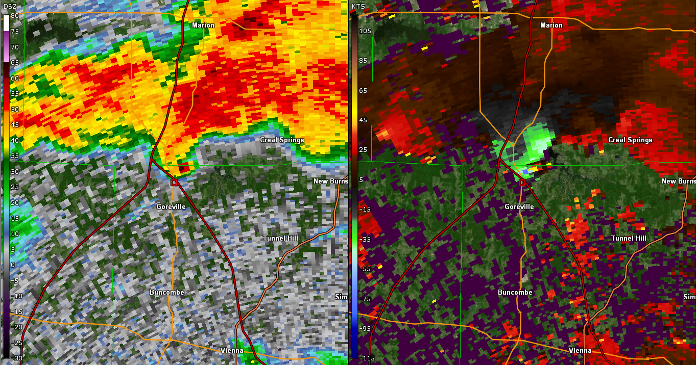
Tornado #1 - Lake of Egypt, Illinois
|
||||||||||||||||
|
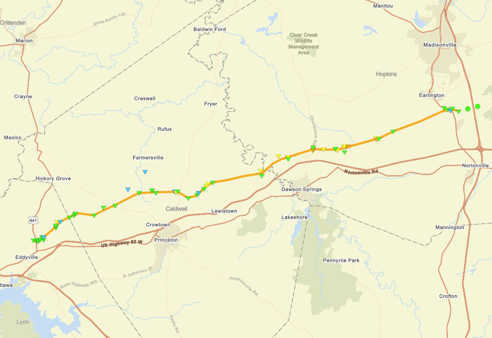
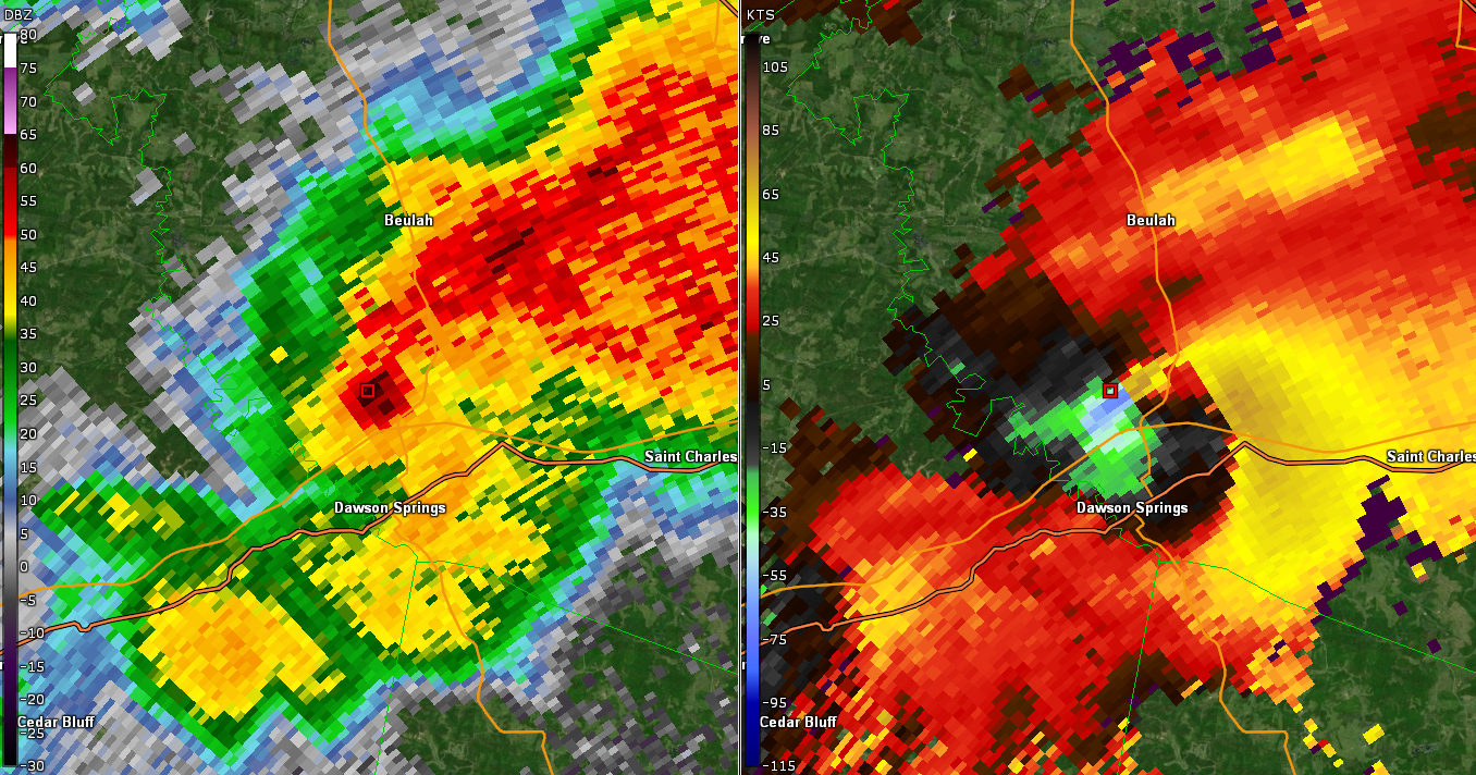
Tornado #2 - Dawson Springs -Charleston, Kentucky
|
||||||||||||||||
|
Tornado #3 - Fairdealing, Missouri
|
||||||||||||||||
|
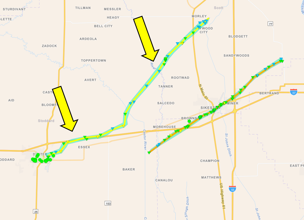
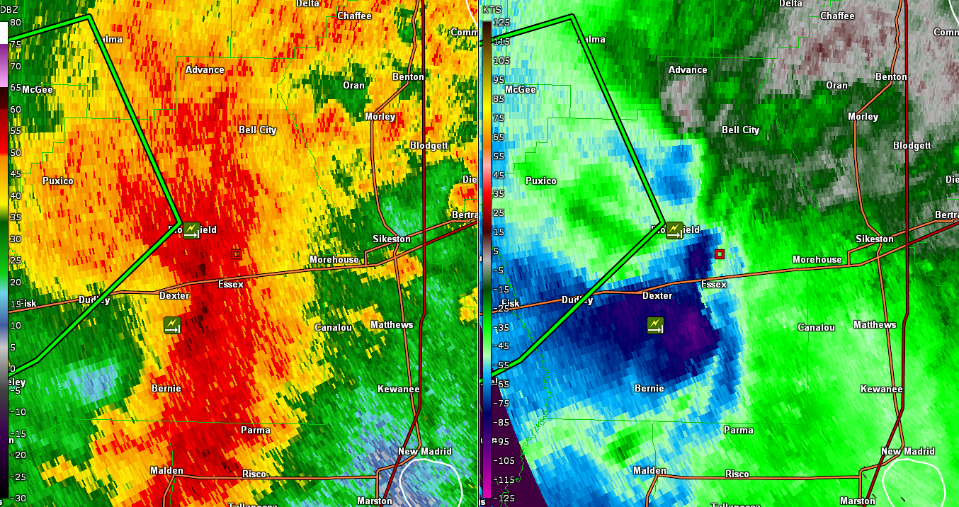
Tornado #4 - Dexter, Missouri
|
||||||||||||||||
|
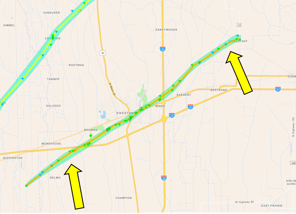
Tornado #5 - Sikeston, Missouri
|
||||||||||||||||
|
Tornado #6 - Bollinger County, Missouri
|
||||||||||||||||
|
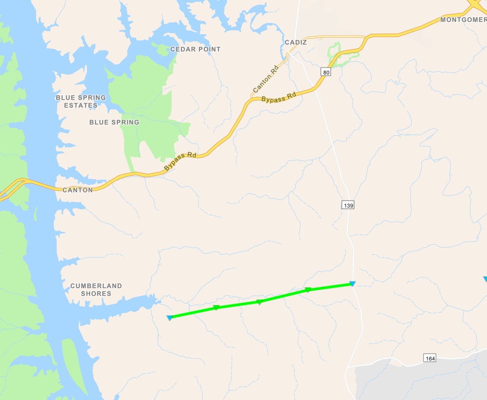
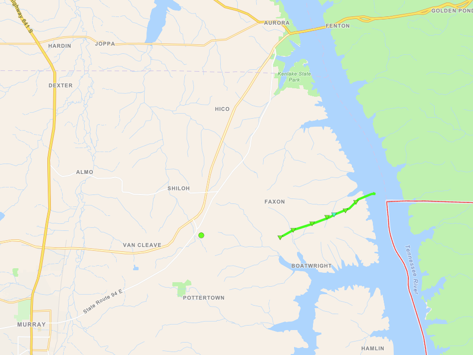
Tornado #7 - Cadiz, Kentucky (South)
|
||||||||||||||||
|
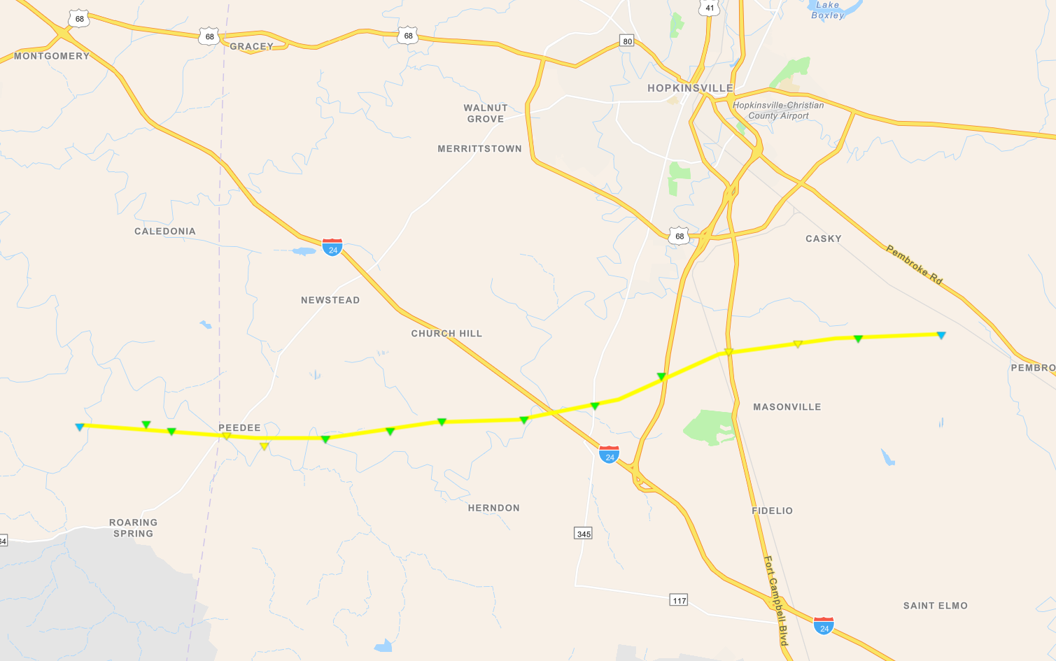
Tornado #8 - Pembroke, Kentucky
|
||||||||||||||||
|
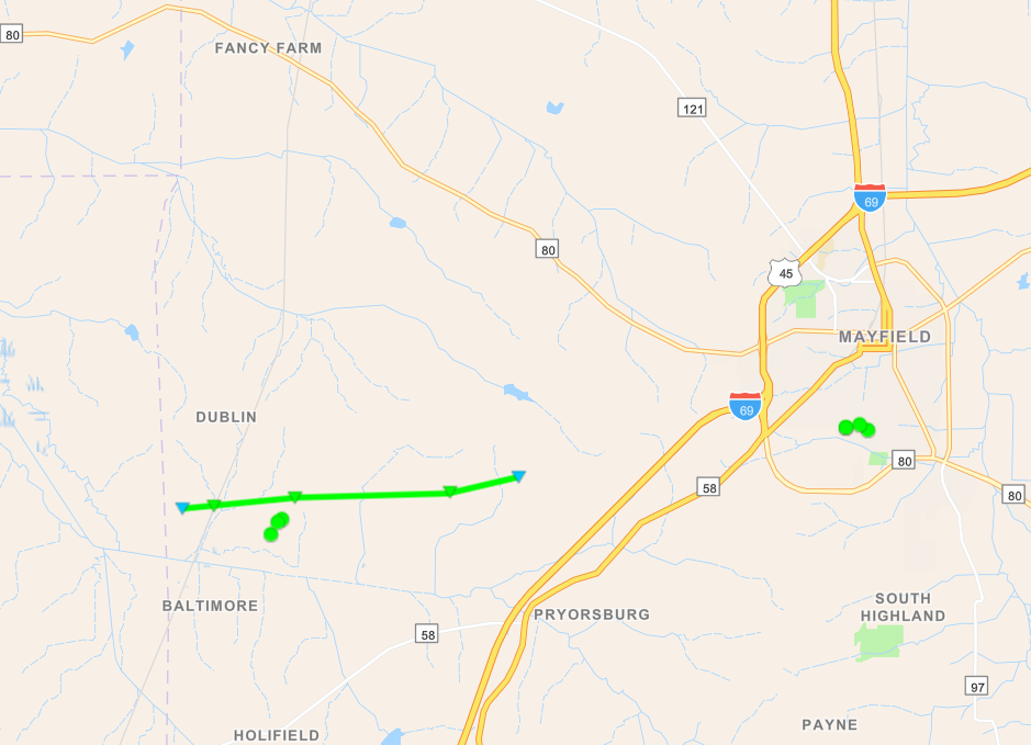
Tornado #9 - Mayfield, Kentucky (West)
|
||||||||||||||||
|
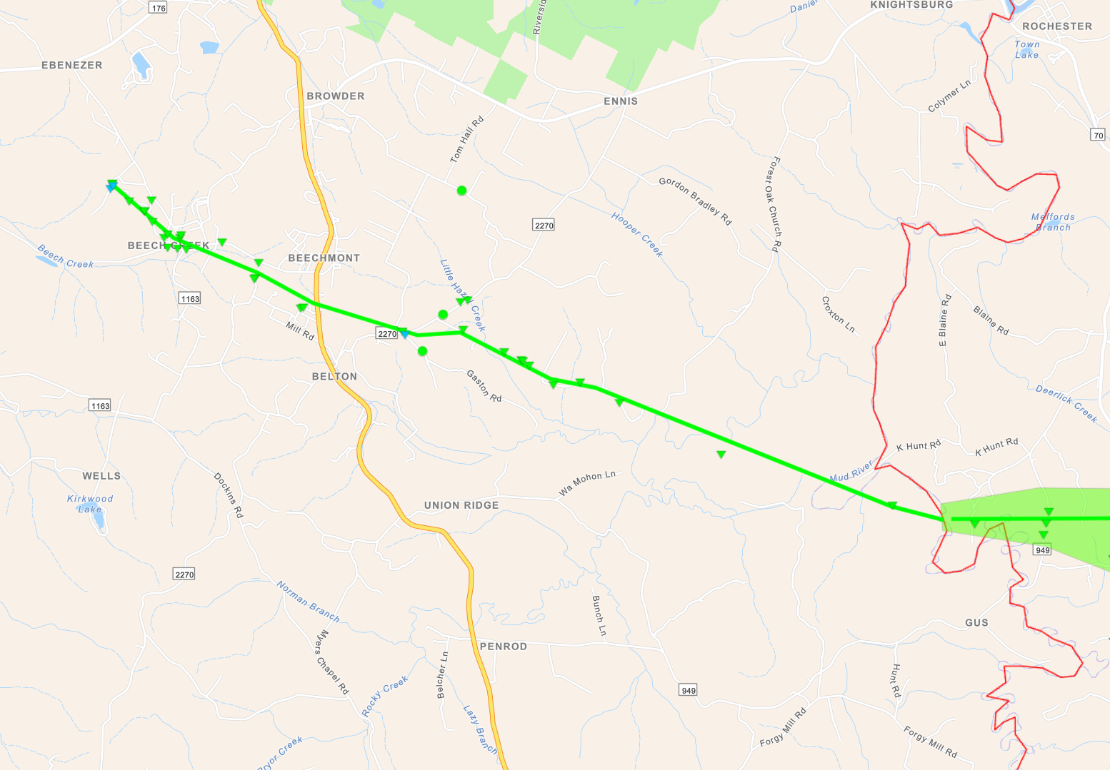
Tornado #10 - Beechmont, Kentucky
|
||||||||||||||||
|
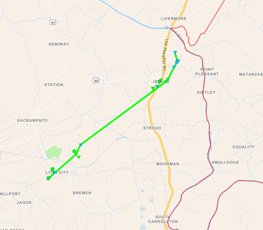
Tornado #11 - Island, Kentucky
|
||||||||||||||||
|
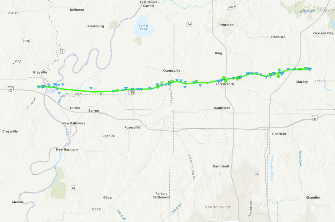
Tornado #12 - Grayville, IL to Somerville, IN
|
||||||||||||||||
|
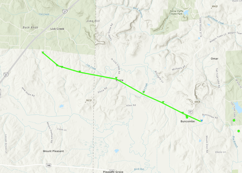
Tornado #13 - Lick Creek and Buncombe, IL
|
||||||||||||||||
|
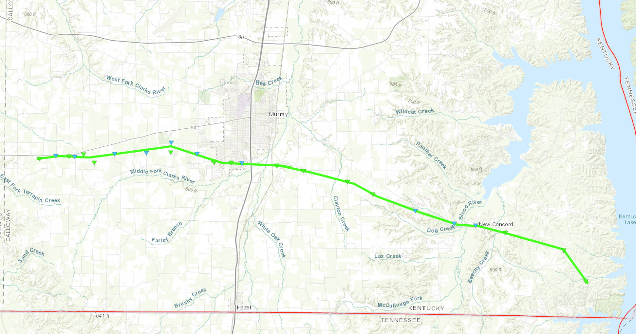
Tornado #14 - Lynn Grove to Murray to New Concord, KY
|
||||||||||||||||
|
Tornado #15 - East of Murray, Kentucky
|
||||||||||||||||
|
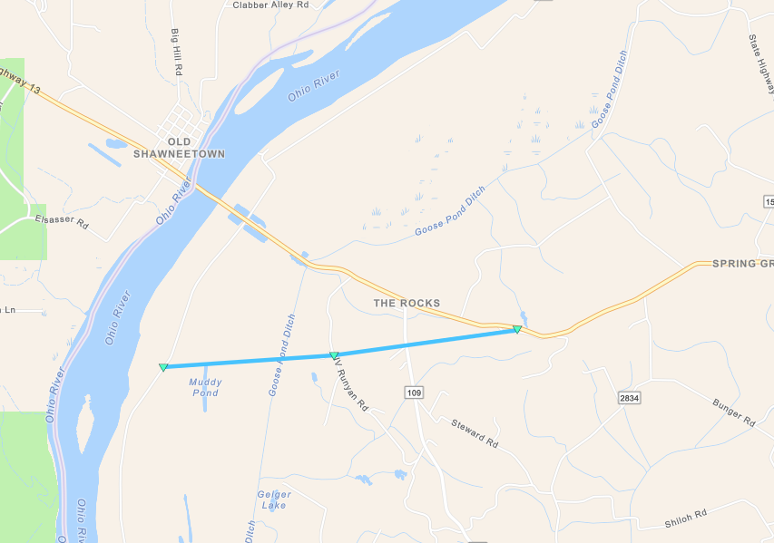
Tornado #16 - SE of Old Shawneetown
|
||||||||||||||||
|
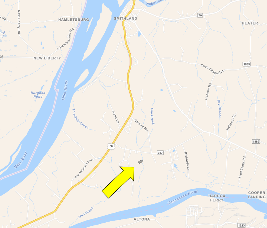
Tornado #17 - NW of Calvert City, KY
|
||||||||||||||||
|
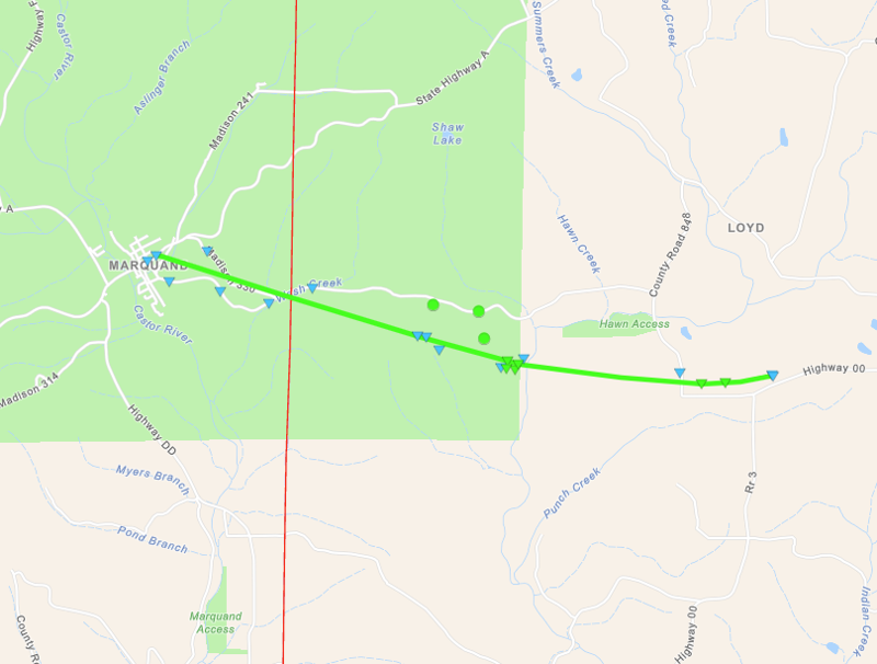
Tornado #18 - W of Van Buren, MO
Track Map 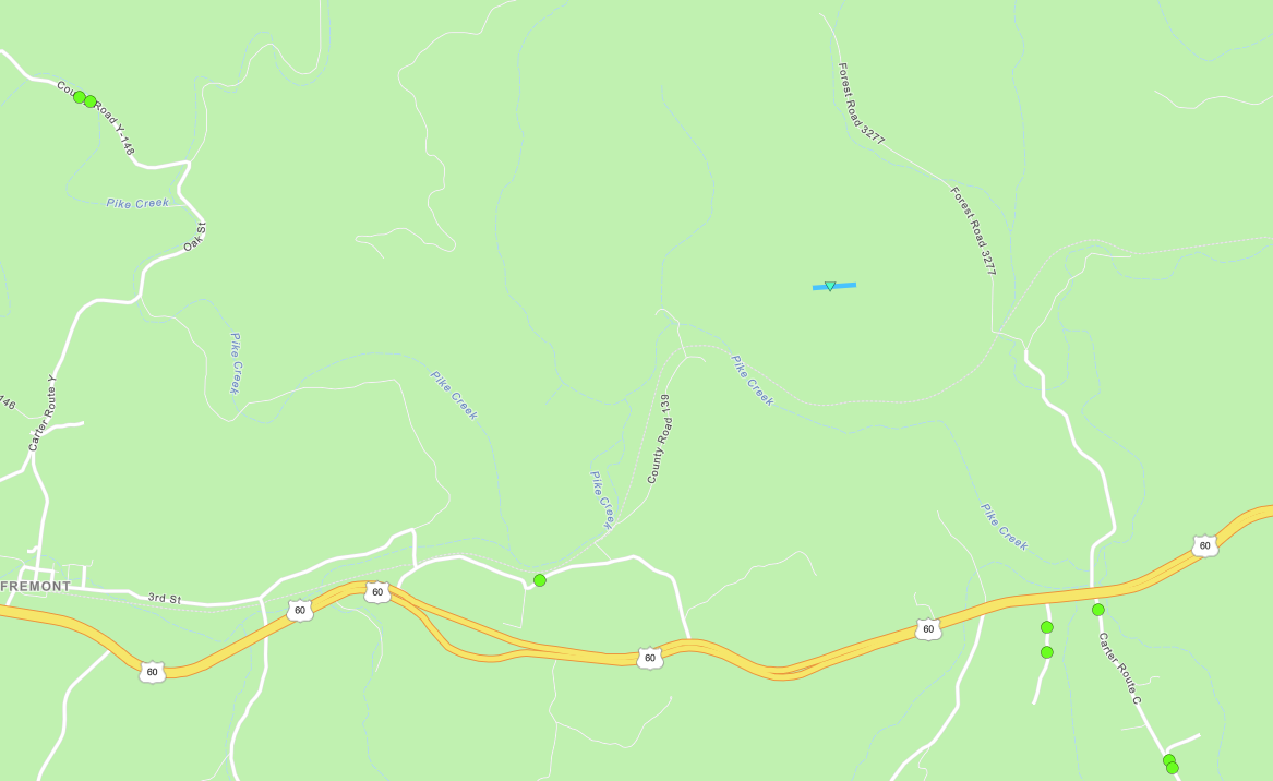 
Downloadable KMZ File (Coming soon) |
||||||||||||||||
The Enhanced Fujita (EF) Scale classifies tornadoes into the following categories:
| EF0 Weak 65-85 mph |
EF1 Moderate 86-110 mph |
EF2 Significant 111-135 mph |
EF3 Severe 136-165 mph |
EF4 Extreme 166-200 mph |
EF5 Catastrophic 200+ mph |
 |
|||||
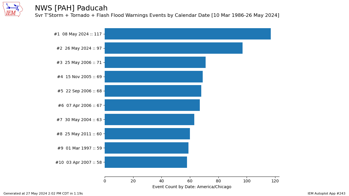
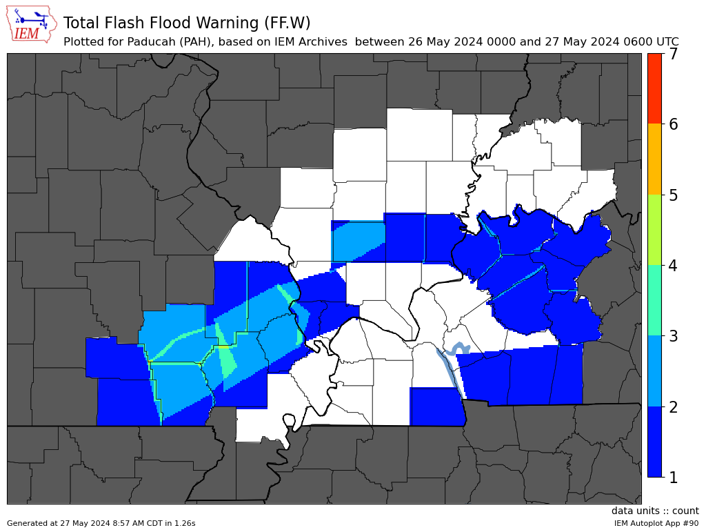
Warning Statistics
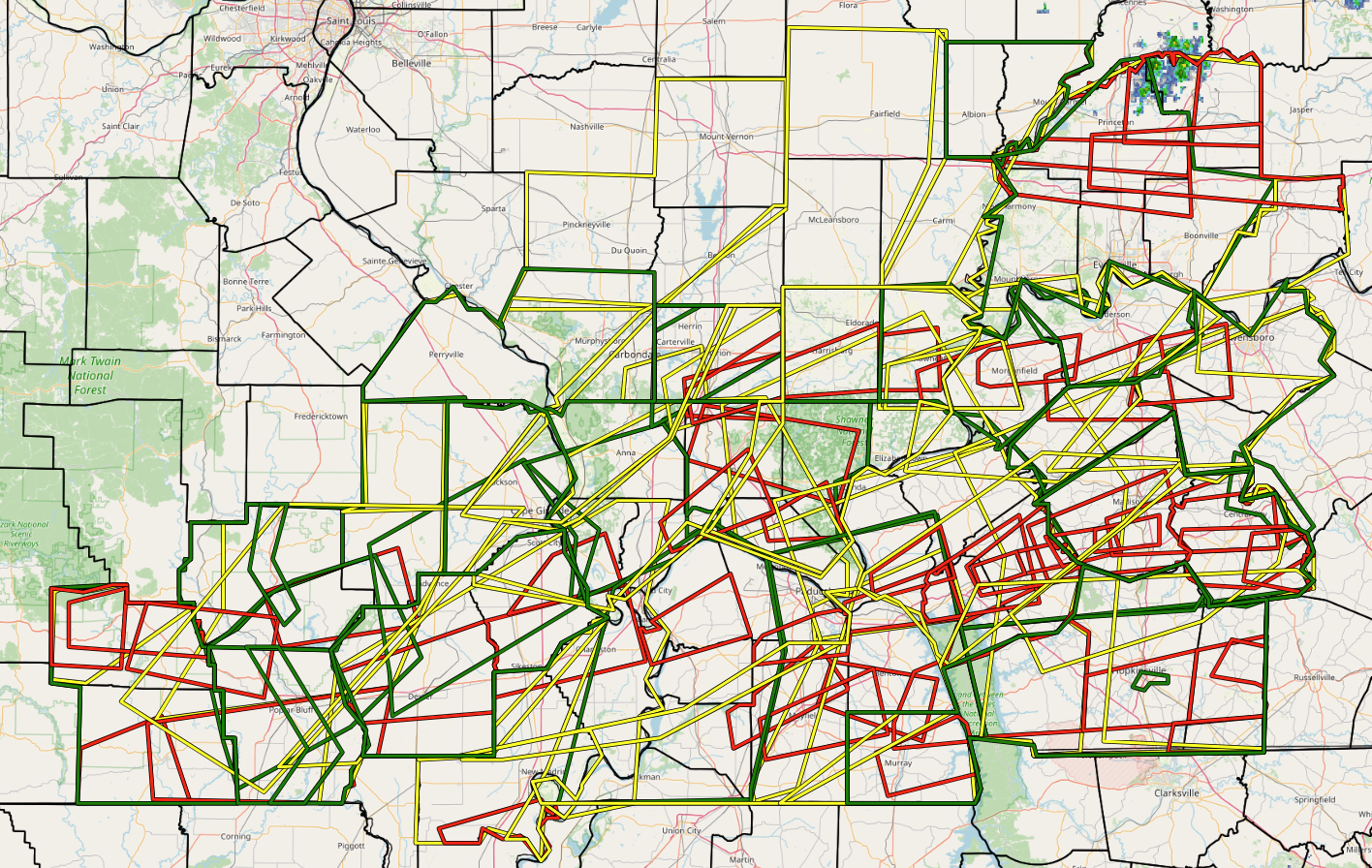
It was an extremely busy day monitoring radar and issuing warnings for this event. NWS Paducah ended up issuing an astounding 97 combined warnings (Severe Thunderstorm, Tornado, and Flash Flood) for our 58 county forecast area during this event. This was the 2nd most warnings issued in a single calendar day on record for our office, only falling shy of the May 8, 2024 event. At the peak of the event shortly before 9 PM, we had 24 total warnings in effect at the same time across parts of our area (Note the graphic below shows 25 because it accidently included a River Flood Warning as one of our Flash Flood Warnings). Every single part of every county in our area was under some kind of warning at some point and many locations received multiple warnings between the morning and evening rounds. A warning was in effect for some portion of our area for over 20 consecutive hours from around 5:30 AM on May 26th until 2 AM on May 27th.
 |
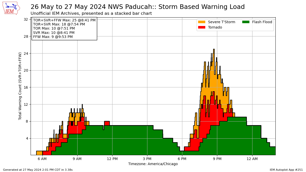 |
| Top 10 calendar days with most warnings issued by NWS Paducah | Bar chart showing the timeline of Severe Thunderstorm, Tornado, and Flash Flood Warnings that were in effect for portions of the NWS Paducah forecast area |
 |
 |
 |
 |
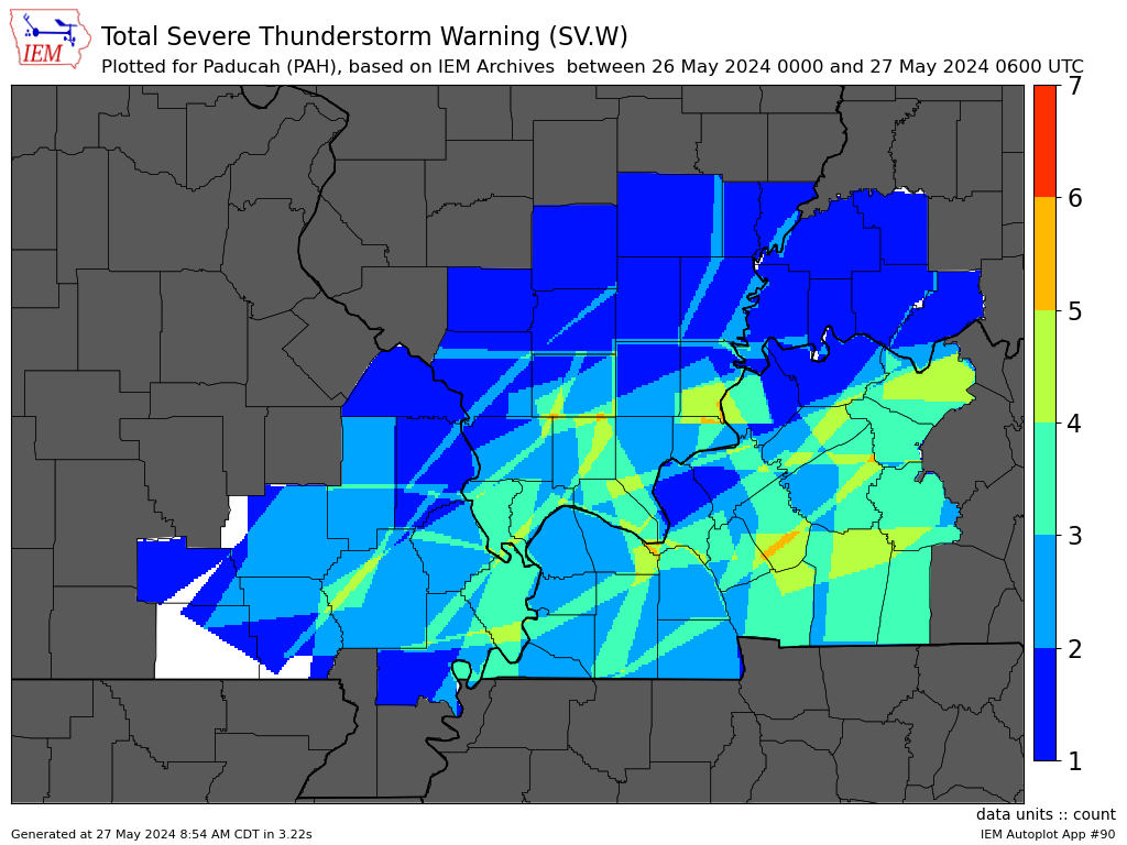
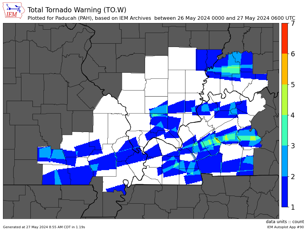
| Severe Thunderstorm Warnings (31) | Tornado Warnings (50) | Flash Flood Warnings (16) | All Warnings combined (97) |
Photos
 |
 |
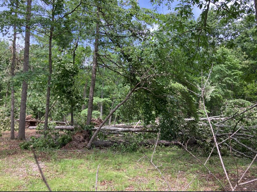 |
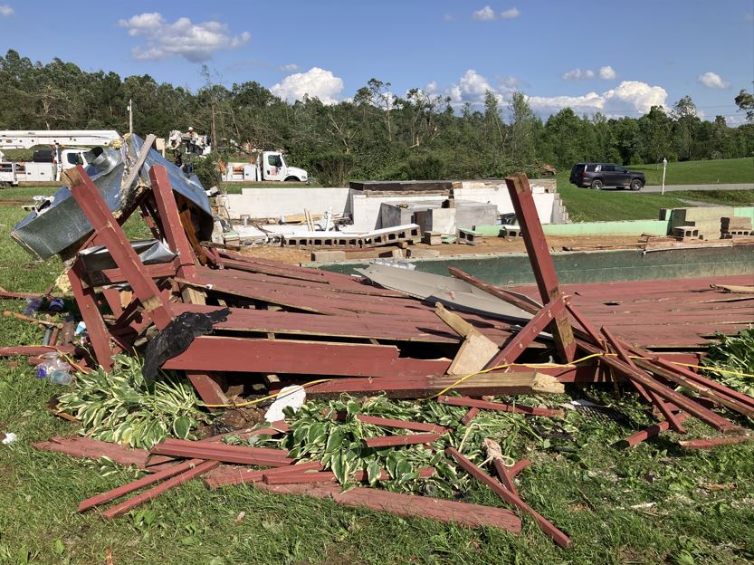 |
| NWS Storm Survey in Bollinger County, MO | NWS Storm Survey in Christian County, KY | NWS Storm Survey in Carter County, MO | NWS Storm Survey near Dawson Spring, KY |
 |
 |
 |
 |
| NWS Storm Survey in Gibson County, IN | NWS Storm Survey near Lake of Egypt, IL | NWS Storm Survey in Ripley County, MO | NWS Storm Survey near Sikeston, MO |
Radar
Two rounds of severe thunderstorms impacted the region on May 26th. The first wave moved through during the morning hours, starting shortly after 5 AM in southeast Missouri. This round exited the region by midday. A lull during the afternoon occurred before additional storms swept through the region during the evening from 6 to 11 PM.
Here is a radar loop of the morning round from 5 AM to 1 PM.
Here is a radar loop of the evening round from 5 PM to 11 PM.
 |
 |
 |
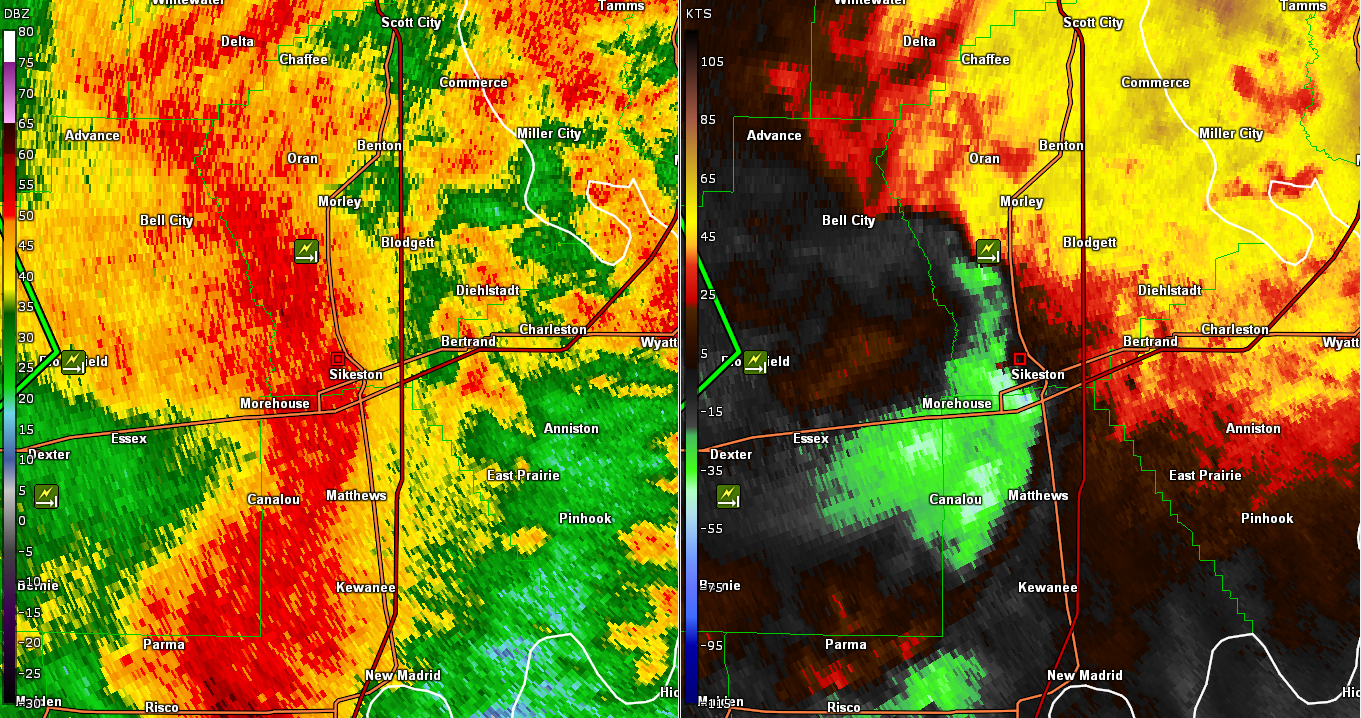 |
| Reflectivity and Storm Relative Velocity of Dawson Springs, KY Tornado at 8:49 PM CDT | Reflectivity and Storm Relative Velocity of Lake of Egypt, IL Tornado at 7:27 PM CDT | Reflectivity and Base Velocity of Microburst in Dexter, MO at 7:11 AM CDT | Reflectivity and Storm Relative Velocity of Sikeston, MO Tornado at 7:23 AM CDT |
Storm Reports
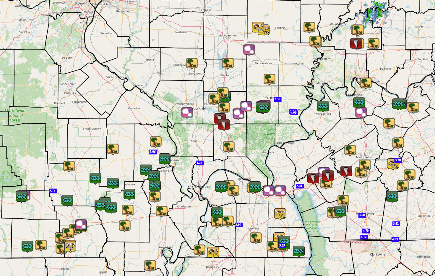 |
| Map of LSR's from the event. |
Preliminary Local Storm Report...Summary National Weather Service Paducah KY 901 AM CDT Mon May 27 2024 ..TIME... ...EVENT... ...CITY LOCATION... ...LAT.LON... ..DATE... ....MAG.... ..COUNTY LOCATION..ST.. ...SOURCE.... ..REMARKS.. 0636 AM Tstm Wnd Dmg Naylor 36.57N 90.61W 05/26/2024 Ripley MO Public Report of roof blown off of home in Naylor MO. 0640 AM Tstm Wnd Dmg 4 NW Harviell 36.70N 90.54W 05/26/2024 Butler MO Public Corrects previous tstm wnd dmg report from 4 NW Harviell. Shed destroyed. Possible tornado. Time was adjusted based on radar. 0640 AM Tstm Wnd Dmg 2 S Doniphan 36.60N 90.82W 05/26/2024 Ripley MO Emergency Mngr Reports of trees down south of Doniphan and power lines down in portions of Ripley County. 0641 AM Tstm Wnd Dmg Fairdealing 36.66N 90.62W 05/26/2024 Ripley MO Public Home damage reported and multiple trees down in the Fairdealing/Harviell area. Possible tornado. 0642 AM Tstm Wnd Dmg 3 NNW Neelyville 36.60N 90.52W 05/26/2024 Butler MO Public Telephone poles snapped, large limbs down, structural damage to storage barns. 0644 AM Tstm Wnd Dmg 4 SW Poplar Bluff 36.73N 90.47W 05/26/2024 Butler MO Trained Spotter Multiple trees and powerlines down. Several very large uprooted tress. Roof off a building. 0645 AM Tstm Wnd Gst 2 NNW Neelyville 36.59N 90.52W 05/26/2024 M60 MPH Butler MO Public 0647 AM Tstm Wnd Dmg Poplar Bluff 36.76N 90.41W 05/26/2024 Butler MO Trained Spotter Tree down on a house and a car. CR 468 in Poplar Bluff. Many trees and lines down. 0650 AM Tstm Wnd Gst 1 S Poplar Bluff 36.75N 90.41W 05/26/2024 E60 MPH Butler MO Public 0706 AM Tstm Wnd Dmg Bloomfield 36.89N 89.93W 05/26/2024 Stoddard MO Emergency Mngr Widespread wind damage across the county. Dexter, Dudley, Puxico, Bloomfield and Essex. 0708 AM Tstm Wnd Dmg 2 S Dexter 36.76N 89.96W 05/26/2024 Stoddard MO Emergency Mngr Multiple trees down, lines down and roof ripped off of home south of Dexter. 0712 AM Flash Flood Poplar Bluff 36.76N 90.41W 05/26/2024 Butler MO Emergency Mngr Corrects previous tstm wnd dmg report from Poplar Bluff. High water reported in multiple locations along business 67 in Poplar Bluff. Specifically at Oak Grove Rd and 67. Not a typical flood location. 0720 AM Tstm Wnd Dmg 2 E Vanduser 37.00N 89.65W 05/26/2024 Scott MO Public Trees uprooted. 0725 AM Tstm Wnd Dmg Sikeston 36.88N 89.58W 05/26/2024 Scott MO Public Taco Johns significant roof damage. 0725 AM Flash Flood Puxico 36.95N 90.16W 05/26/2024 Stoddard MO Emergency Mngr Flash flooding and road washouts reported around Puxico, MO. 0731 AM Tstm Wnd Dmg Portageville 36.43N 89.70W 05/26/2024 New Madrid MO Public Multiple trees down in the Portageville and New Madrid areas. 0755 AM Tstm Wnd Dmg Arlington 36.79N 89.01W 05/26/2024 Carlisle KY Emergency Mngr Multiple trees down. Many across SR 80 between Arlington and Milburn. 0803 AM Tstm Wnd Dmg Kevil 37.09N 88.89W 05/26/2024 Ballard KY Emergency Mngr Trees down and flooding. 0808 AM Tstm Wnd Dmg 3 SE Kevil 37.05N 88.84W 05/26/2024 McCracken KY Emergency Mngr Tree blown down on house in western McCracken County. 0810 AM Tstm Wnd Dmg Hickman 36.56N 89.19W 05/26/2024 Fulton KY Emergency Mngr Trees down north and east sides of Hickman County. 0810 AM Flood Johnston City 37.82N 88.93W 05/26/2024 Williamson IL Trained Spotter Flooded roads. 0815 AM Flash Flood Oran 37.09N 89.65W 05/26/2024 Scott MO Public Up to a foot of water flowing on multiple streets in Oran. 0815 AM Tstm Wnd Dmg Paducah 37.07N 88.64W 05/26/2024 McCracken KY Emergency Mngr Trees blown down and blocking the road at Clarkline and Old Mayfield Roads. 0819 AM Tstm Wnd Dmg Milburn 36.80N 88.90W 05/26/2024 Carlisle KY Emergency Mngr Multiple trees down in the Milburn and Beulah areas. 0820 AM Tstm Wnd Dmg 2 NNW Sedalia 36.66N 88.61W 05/26/2024 Graves KY Emergency Mngr People trapped in home. Possible tornado. 0822 AM Flash Flood Cape Girardeau 37.31N 89.55W 05/26/2024 Cape Girardeau MO Public Report from mPING: Street/road flooding. 0822 AM Tstm Wnd Gst 1 SW Cayce 36.54N 89.05W 05/26/2024 M67 MPH Fulton KY Amateur Radio Mmultiple 4-6 in limbs and 2 large mature tree down. One uprooted tree. 0832 AM Tstm Wnd Dmg 2 SW Murray 36.59N 88.34W 05/26/2024 Calloway KY Public Multiple trees down. 0833 AM Tstm Wnd Gst Benton 36.86N 88.36W 05/26/2024 E70 MPH Marshall KY Trained Spotter 0835 AM Tstm Wnd Gst 3 ESE Kirksey 36.66N 88.37W 05/26/2024 M64 MPH Calloway KY AWOS 0835 AM Tstm Wnd Dmg Murray 36.61N 88.32W 05/26/2024 Calloway KY Public estimated 70 mph winds. Trees down on the southwest side of Murray. 0848 AM Tstm Wnd Dmg Princeton 37.11N 87.89W 05/26/2024 Caldwell KY Public Trees down in Princeton. 0850 AM Tstm Wnd Dmg Lynn Grove 36.59N 88.44W 05/26/2024 Calloway KY Public Tree blown over on house causing structural damage. 0855 AM Tstm Wnd Dmg Cadiz 36.87N 87.82W 05/26/2024 Trigg KY Emergency Mngr Cadiz County Hospital has no power and no generator. Multiple trees on lines near hospital. 0856 AM Tstm Wnd Dmg 3 E Cadiz 36.87N 87.77W 05/26/2024 Trigg KY Trained Spotter Lots of trees down, many on roads such as Oliver Rd and N. Montgomery Rd. 0900 AM Tstm Wnd Dmg Cerulean 36.97N 87.71W 05/26/2024 Trigg KY Public Trees down over much Trigg County. 0903 AM Tstm Wnd Dmg Nebo 37.38N 87.64W 05/26/2024 Hopkins KY Broadcast Media Power lines leaning and metal across the road. 0925 AM Tstm Wnd Dmg Island 37.44N 87.15W 05/26/2024 McLean KY Public Trees down and structural damage. 0930 AM Flash Flood Murray 36.61N 88.32W 05/26/2024 Calloway KY NWS Employee Widespread flash flooding in Murray, Ky. 0932 AM Tstm Wnd Dmg 4 NNE Calhoun 37.60N 87.24W 05/26/2024 McLean KY Public Trees blown down a few on houses. 0949 AM Tstm Wnd Dmg 3 SSE Drakesboro 37.18N 87.03W 05/26/2024 Muhlenberg KY Emergency Mngr Extensive damage to houses in the communities of Beechmont and Drakesboro with searches ongoing. Many roads blocked. Time estimated by radar. 0950 AM Flash Flood 3 S Zalma 37.11N 90.08W 05/26/2024 Bollinger MO Emergency Mngr Water over MO51 north of Arab. 0950 AM Flash Flood Lowndes 37.15N 90.26W 05/26/2024 Wayne MO Emergency Mngr Water over Hwy E in Lowndes. 0955 AM Tstm Wnd Gst 3 NW Powderly 37.27N 87.20W 05/26/2024 M61 MPH Muhlenberg KY Mesonet Mesonet station GFSK2 Greenville KY. 1010 AM Flash Flood Cape Girardeau 37.31N 89.55W 05/26/2024 Cape Girardeau MO Emergency Mngr Street flooding in Cape Girardeau. 1050 AM Tstm Wnd Dmg Rosewood 37.09N 87.10W 05/26/2024 Muhlenberg KY Trained Spotter Many branches and tree limbs down. A few trees down along hedge rows. 1115 AM Flood 1 ENE Paducah 37.08N 88.62W 05/26/2024 McCracken KY Broadcast Media Flooding over railroad crossing on Jackson Street. 1200 PM Flash Flood 4 W Gracey 36.88N 87.74W 05/26/2024 Trigg KY Public Flooding over US68 near I-24. 1215 PM Flood 1 SSW Van Buren 37.00N 91.02W 05/26/2024 Carter MO Law Enforcement Minor street flooding on multiple roads in Van Buren. 1230 PM Flash Flood 6 WSW Hamlin 36.55N 88.17W 05/26/2024 Calloway KY Emergency Mngr Up to 3 feet of water over the road of Speaker Trail at KY121. 0115 PM Flood 4 W Clifty 37.00N 87.21W 05/26/2024 Todd KY Trained Spotter A foot of water over the roads. 0200 PM Flood 2 NNW Murray 36.63N 88.32W 05/26/2024 Calloway KY Emergency Mngr N 16th St closed due to flooding. 0230 PM Flood 4 S Briar 36.59N 90.96W 05/26/2024 Ripley MO Emergency Mngr Ongoing flooding of several roads due to overflowing creeks continues. 0646 PM Tornado 6 N Goreville 37.64N 88.98W 05/26/2024 Williamson IL Public Tornado crossing I-57 south of Marion IL near Lake of Egypt. 0648 PM Tornado 3 NE Goreville 37.59N 88.94W 05/26/2024 Johnson IL Public Houses severely damaged. Trailers flipped. 0700 PM Hail 5 NNE Creal Springs 37.68N 88.79W 05/26/2024 E1.00 Inch Williamson IL Amateur Radio 0700 PM Tstm Wnd Dmg Van Buren 37.01N 91.01W 05/26/2024 Carter MO Emergency Mngr Trees down in Van Buren. 0705 PM Hail 1 ENE Van Buren 37.01N 90.99W 05/26/2024 M1.00 Inch Carter MO Emergency Mngr 1 hail and trees down. 0710 PM Hail 6 NW Carrier Mills 37.74N 88.71W 05/26/2024 M2.00 Inch Williamson IL Trained Spotter 0715 PM Hail 1 E Ledbetter 37.05N 88.48W 05/26/2024 M1.00 Inch Livingston KY Trained Spotter 0728 PM Hail 1 S Muddy 37.75N 88.52W 05/26/2024 M1.00 Inch Saline IL Public 1 inch sized hail. 0730 PM Tstm Wnd Dmg 6 NNW Glenallen 37.39N 90.08W 05/26/2024 Bollinger MO Emergency Mngr Trees down on 2 separate homes near the intersection of county road 840 and Highway 00. 0731 PM Hail 1 NNW Calvert City 37.05N 88.36W 05/26/2024 E1.00 Inch Marshall KY Emergency Mngr 0731 PM Hail Harrisburg 37.73N 88.54W 05/26/2024 M1.25 Inch Saline IL Trained Spotter 0735 PM Hail Harrisburg 37.74N 88.55W 05/26/2024 E1.00 Inch Saline IL Emergency Mngr Pea to quarter sized hail. 0735 PM Flash Flood 1 SSW Van Buren 37.00N 91.02W 05/26/2024 Carter MO Emergency Mngr Water is covering roads in Van Buren, including some that do not normally flood. 0740 PM Tstm Wnd Dmg 4 W Lodi 37.25N 90.53W 05/26/2024 Wayne MO Emergency Mngr Trees blown down on vehicles in Sam A Baker Park. 0747 PM Hail 6 S Murphysboro 37.69N 89.32W 05/26/2024 E1.00 Inch Jackson IL Emergency Mngr 0755 PM Tstm Wnd Dmg Princeton 38.36N 87.57W 05/26/2024 Gibson IN Broadcast Media Trees down and a few power poles snapped in West Frankfort. 0755 PM Hail Dahlgren 38.20N 88.68W 05/26/2024 M1.00 Inch Hamilton IL Emergency Mngr 0800 PM Hail 1 NE Robards 37.69N 87.53W 05/26/2024 E1.00 Inch Henderson KY Emergency Mngr 0800 PM Tstm Wnd Dmg 3 NNW Johnston City 37.85N 88.95W 05/26/2024 Williamson IL Public Power lines down in Stritz. 0800 PM Tstm Wnd Gst Sims 38.36N 88.53W 05/26/2024 E60 MPH Wayne IL Trained Spotter Estimated 60 mph winds near Sims. 0803 PM Tstm Wnd Gst 2 N Wayne City 38.38N 88.59W 05/26/2024 M62 MPH Wayne IL Trained Spotter 0805 PM Tstm Wnd Dmg 2 W Ewing 38.09N 88.90W 05/26/2024 Franklin IL Trained Spotter trees down. 0805 PM Tstm Wnd Dmg Fruitland 37.45N 89.64W 05/26/2024 Cape Girardeau MO Fire Dept/Rescue Trees uprooted and fell on house. 0805 PM Tstm Wnd Dmg Herrin 37.80N 89.04W 05/26/2024 Williamson IL Fire Dept/Rescue Trees uprooted. 0810 PM Flash Flood Williamsville 36.97N 90.55W 05/26/2024 Wayne MO Law Enforcement Water over the road in Williamsville at CR417 and MO49. 0814 PM Tornado 5 SSE Fredonia 37.15N 88.02W 05/26/2024 Caldwell KY Trained Spotter Tornado ongoing at this time. 0815 PM Tstm Wnd Dmg 2 NNW Broughton 37.96N 88.47W 05/26/2024 Hamilton IL Emergency Mngr Several trees down near Broughton and Dale. 0816 PM Hail Farmersville 37.20N 87.91W 05/26/2024 E2.50 Inch Caldwell KY Public Tennis to Baseball size hail. 0820 PM Tstm Wnd Dmg Albion 38.38N 88.06W 05/26/2024 Edwards IL Trained Spotter Multiple trees down in town. 0824 PM Tornado 4 NNE Princeton 37.17N 87.87W 05/26/2024 Caldwell KY Emergency Mngr *** 3 INJ *** Trees down across multiple roads making travel impossible. 3 minor injuries reported about 4-5 miles north of Princeton. 0824 PM Flash Flood 1 ESE Allenville 37.22N 89.74W 05/26/2024 Cape Girardeau MO Public Corrects previous flash flood report from 1 ESE Allenville. Flooding on multiple county roads in Cape Girardeau county. 0825 PM Tstm Wnd Dmg 4 SSW Tamaroa 38.09N 89.27W 05/26/2024 Perry IL Emergency Mngr Power lines and tree limbs down across the eastern parts of the county. 0827 PM Tstm Wnd Dmg Grayville 38.26N 87.99W 05/26/2024 Wabash IL Amateur Radio A few trees uprooted, a carport damaged, and damaged cars by falling tree debris. Time estimated from radar. 0829 PM Tstm Wnd Dmg Marion 37.73N 88.94W 05/26/2024 Williamson IL Emergency Mngr Power lines down across the county. 0835 PM Hail Poplar Bluff 36.77N 90.41W 05/26/2024 M1.50 Inch Butler MO Emergency Mngr Dime, quarter and ping pong ball sized hail reported in many locations across the county. 0842 PM Tstm Wnd Dmg Vienna 37.41N 88.89W 05/26/2024 Johnson IL Public Roof blown of a shed. 0844 PM Tstm Wnd Dmg 4 WSW Newburgh 37.93N 87.48W 05/26/2024 Vanderburgh IN Trained Spotter Wind gusts to near 65 mph. 0847 PM Tstm Wnd Dmg 1 NE Princeton 38.36N 87.56W 05/26/2024 Gibson IN Emergency Mngr Lines down and broken power poles thorughout Gibson County. 0851 PM Tstm Wnd Dmg Fort Branch 38.25N 87.56W 05/26/2024 Gibson IN Trained Spotter Billboard blown down in Fort Branch. Time estimated from radar. 0851 PM Tornado Fort Branch 38.25N 87.58W 05/26/2024 Gibson IN Trained Spotter 0852 PM Tornado 3 NNE Dawson Springs 37.21N 87.68W 05/26/2024 Hopkins KY Emergency Mngr KYEM reports damage to around 20 homes in the Charleston Community north of Dawson Springs. 0859 PM Tstm Wnd Dmg Mackey 38.25N 87.40W 05/26/2024 Gibson IN Trained Spotter Roof partially removed from a Post Office building in Mackey. Time estimated. 0900 PM Tstm Wnd Dmg 2 ENE Saint Charles 37.20N 87.53W 05/26/2024 Hopkins KY Broadcast Media Numerous large trees down on the WK Parkway/Interstate 69 between Central City and Dawson Springs. 0900 PM Tstm Wnd Dmg 1 NNW Grayville 38.27N 88.00W 05/26/2024 Edwards IL Trained Spotter A few treees uprooted, carpoort destroyed. Damage to cars from falling carport and trees. Cornstalks blown across road. 0900 PM Flood 2 W Acorn Ridge 36.91N 90.10W 05/26/2024 Stoddard MO Emergency Mngr Highway T between Highway 51 and Little J Highway is closed due to flooding. 0901 PM Flash Flood 2 NNW Asherville 36.93N 90.21W 05/26/2024 Stoddard MO Emergency Mngr Highway T near Puxico is closed from Hwy 51 to Hwy J due to flooding. 0905 PM Flood 1 N La Center 37.08N 88.97W 05/26/2024 Ballard KY Amateur Radio 60 mph gusts. 0915 PM Tstm Wnd Dmg 2 NNW Mortons Gap 37.26N 87.49W 05/26/2024 Hopkins KY Trained Spotter Significant damage to several homes and trees in the vicinity of Barnsley Loop and U.S. 41. Possible tornado. 0915 PM Flood 5 SSE Henderson 37.77N 87.55W 05/26/2024 Henderson KY Emergency Mngr Flood water across road on Highway 41. Mile post 16 and 17. 0919 PM Tstm Wnd Dmg Philpot 37.73N 86.99W 05/26/2024 Daviess KY Trained Spotter Trees down. 0920 PM Flash Flood Harrisburg 37.73N 88.55W 05/26/2024 Saline IL Emergency Mngr A lot of street flooding in town. 0925 PM Flash Flood Harrisburg 37.73N 88.54W 05/26/2024 Saline IL Emergency Mngr Heavy street flooding in Harrisburg with 6-12 inches deeper water than usual in floodprone streets. 0930 PM Flash Flood 2 SSE Uniontown 37.74N 87.92W 05/26/2024 Union KY Emergency Mngr Water over KY130 between Morganfield and Uniontown. 0930 PM Flash Flood Bardwell 36.87N 89.01W 05/26/2024 Carlisle KY Emergency Mngr Trees down and flash flooding in various creeks and low water crossings across the county. 0938 PM Flash Flood Owensboro 37.76N 87.12W 05/26/2024 Daviess KY Emergency Mngr Widespread street flooding. 0944 PM Flash Flood 1 ESE Harrisburg 37.73N 88.53W 05/26/2024 Saline IL Law Enforcement Fire department dispatched to car floating in water near Walmart. Water crossing US45 SW of Harrisburg. 0945 PM Flash Flood 2 W Owensboro 37.76N 87.15W 05/26/2024 Daviess KY Trained Spotter Several inches of water over Carter Rd between McFarland Ave and Flamingo Ave. 0103 AM Flood 5 SSE Brownwood 37.02N 89.91W 05/27/2024 Stoddard MO Law Enforcement Several roads in the county still closed due to water. 0110 AM Flood 1 SSE Chaffee 37.17N 89.66W 05/27/2024 Scott MO Law Enforcement Several roads remain closed across the county due to high water.
Rain Reports
Widespread rainfall amounts of 1 to 4 inches occurred across the region, along with localized higher amounts up to 5 inches. The highest amounts were focused across southeast Missouri, western Kentucky, and far southern Illinois. Multiple rounds of intense rainfall lead to flash flooding with numerous roads closed due to high water flowing across them.
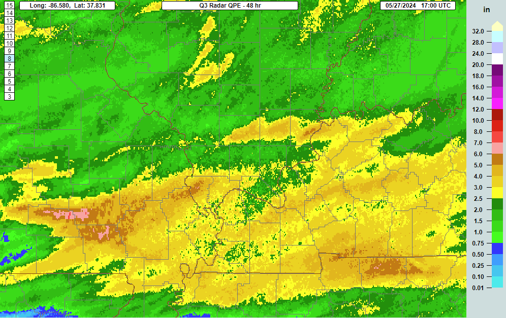 |
| MRMS rainfall estimates |
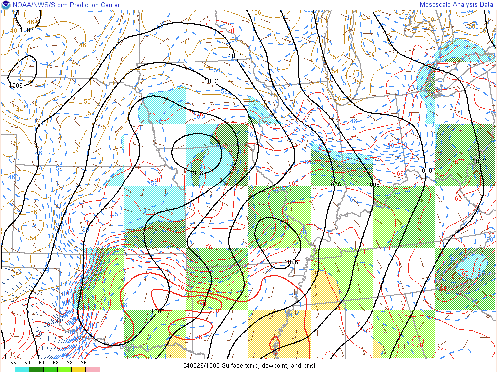
Environment
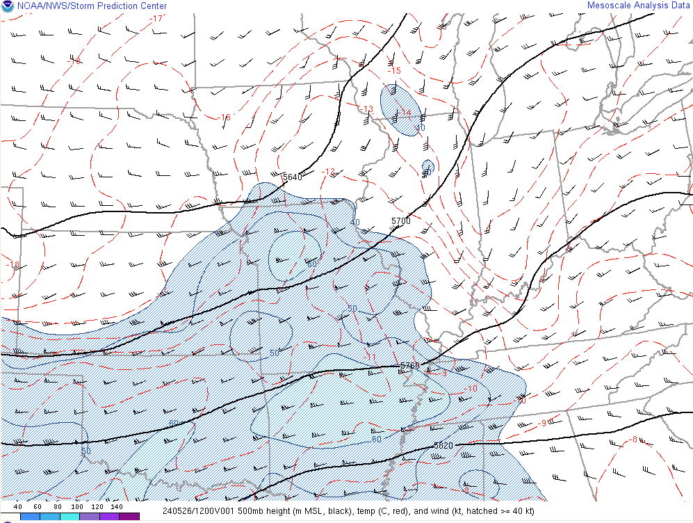
The synoptic environment was characterized by a shortwave trough centered across the center of the country with a 60 knot mid level jet moving across northern Arkansas. A weak surface low was moving into southeast Missouri during the morning with a secondary low located further northwest. A warm frontal boundary was draped across our area. The most unstable environment was in place across southeast Missouri and far western Kentucky where MLCAPE values of 1500-2500 J/kg were present.
 |
 |
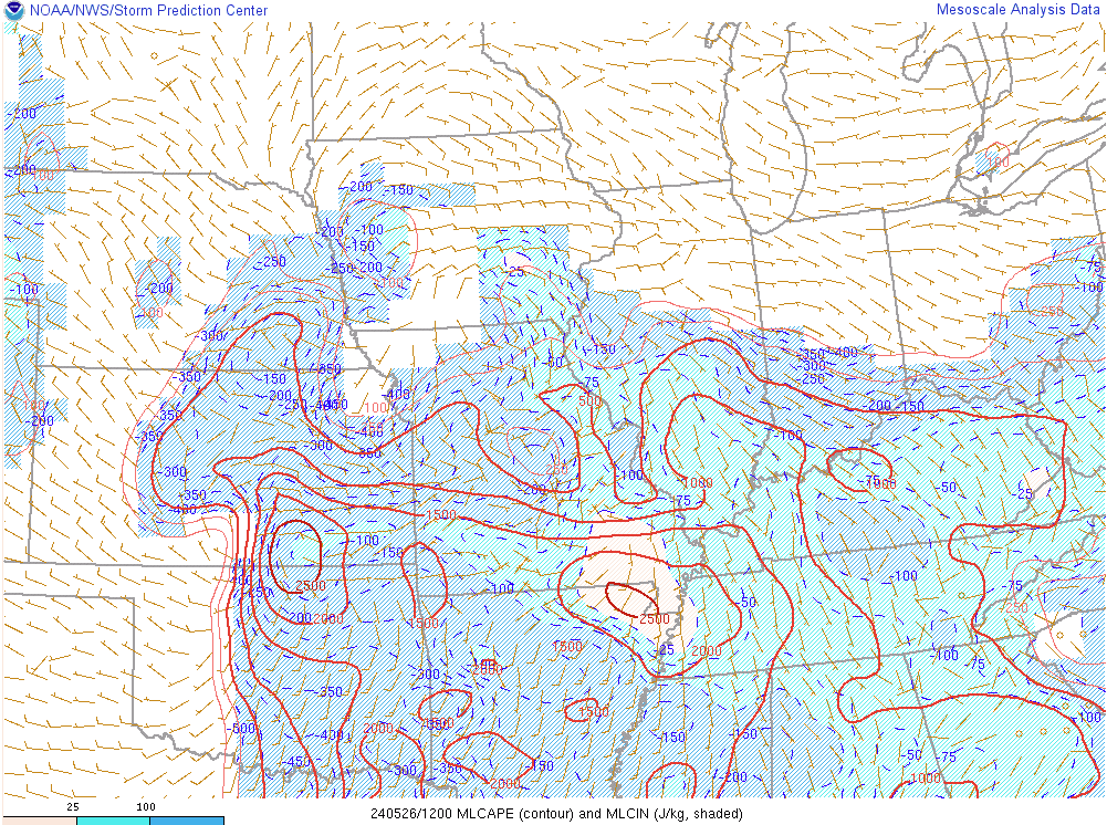 |
| Surface chart at 7 AM May 26, 2024 | 500mb chart at 7 AM May 26, 2024 | Mixed-Layer CAPE at 7 AM May 26, 2024 |
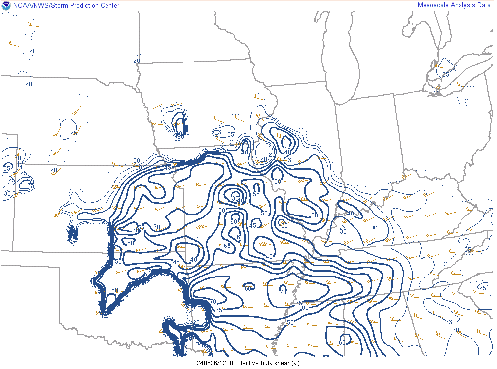
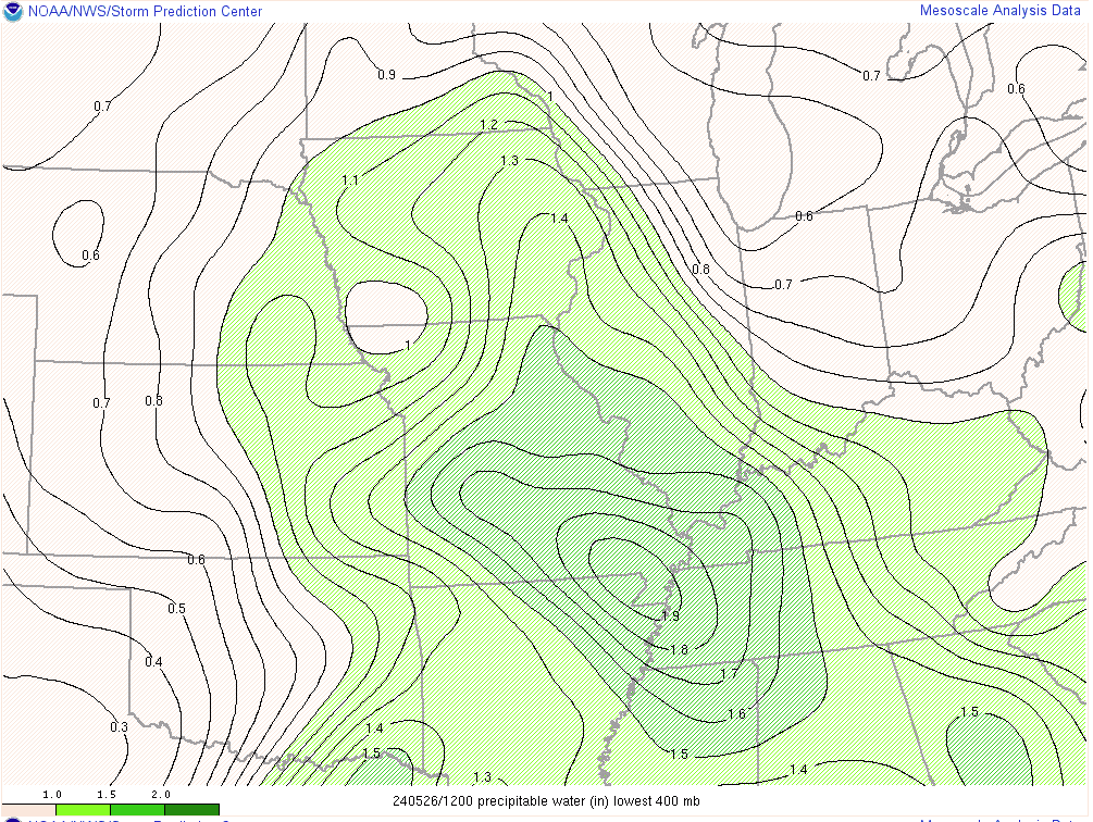
There was copious amounts of moisture to work with as precipitable water values peaked around 1.9 inches during the morning. This allowed storms to produce very efficient rainfall rates of 1 to 2 inches per hour. Effective shear was also quite impressive with values over 40 kts across southeast Missouri ahead of the bowing line of storms. All of these ingredients provided the needed fuel for the storms to continue as they quickly tracked east into western Kentucky through the morning. There were embedded circulations within the line that likely produced several tornadoes along its path.
 |
 |
 |
| 0-6km effective shear at 7 AM May 26, 2024 | Precipitable Water Values at 7 AM May 26, 2024 | Significant Tornado Parameter (STP) at 7 AM May 26, 2024 |
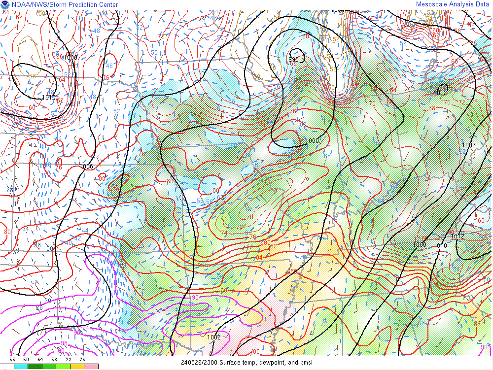
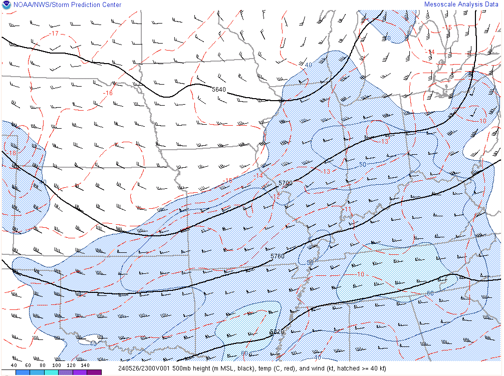
After the morning round of storms, satellite imagery indicated rapid clearing across the region during the afternoon. Temperatures rose back into the 80s with dewpoints rising into the upper 60s to mid 70s. This produced a very unstable environment by early evening with MLCAPE values of 3000-4000 J/kg.
 |
 |
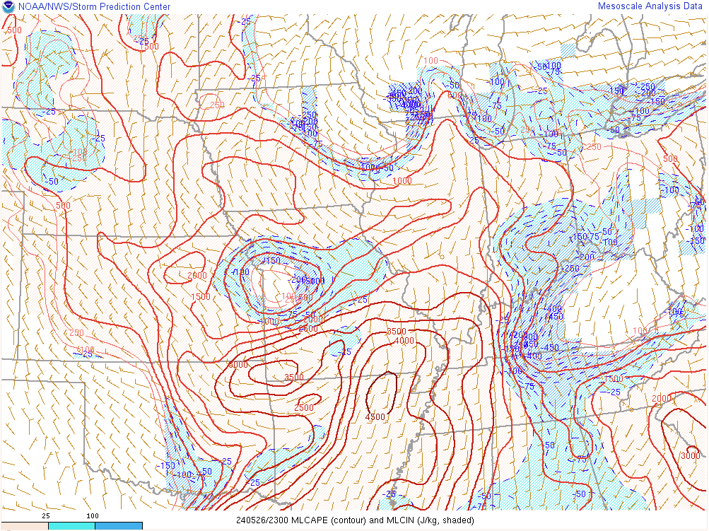 |
| Surface chart at 6 PM May 26, 2024 | 500mb chart at 6 PM May 26, 2024 | Mixed-Layer CAPE at 6 PM May 26, 2024 |
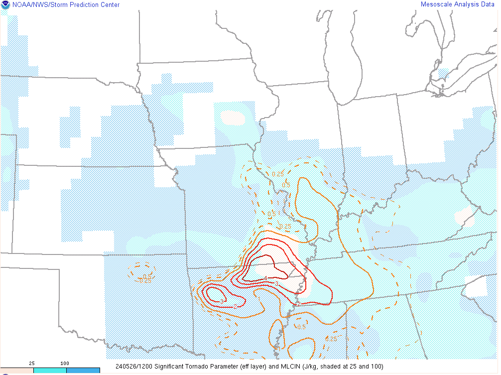
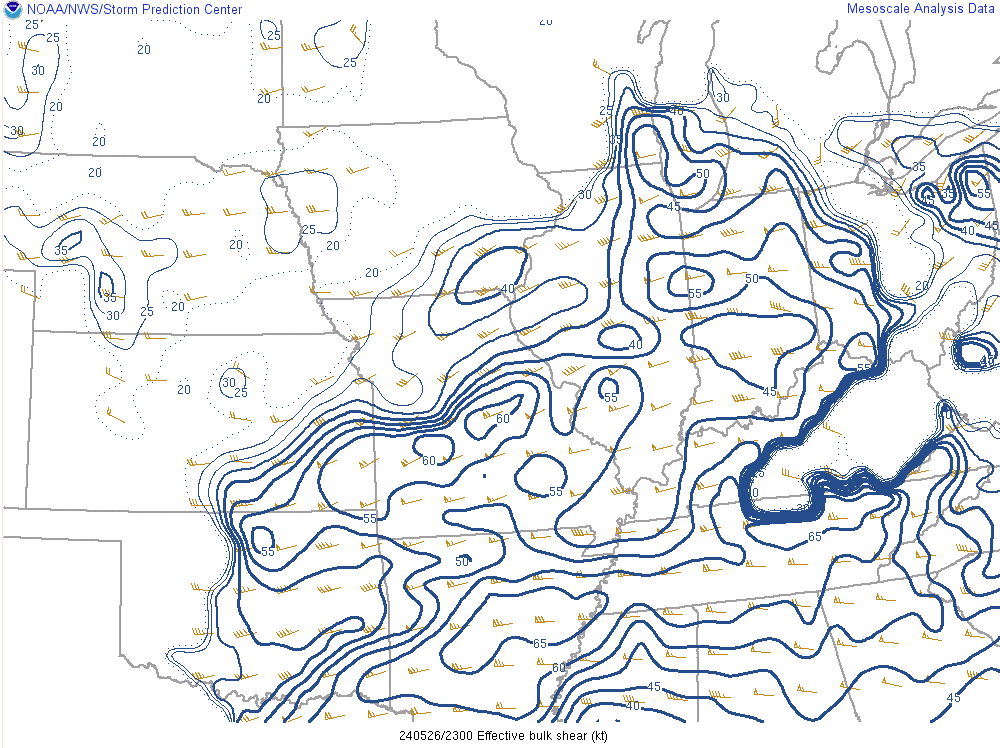
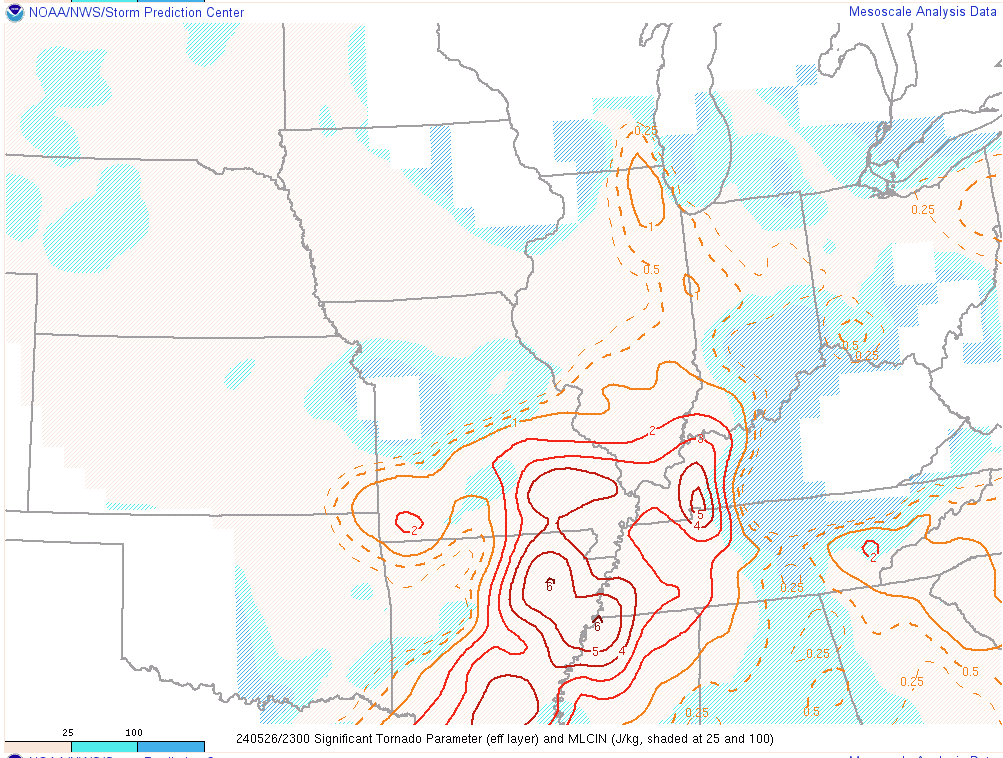
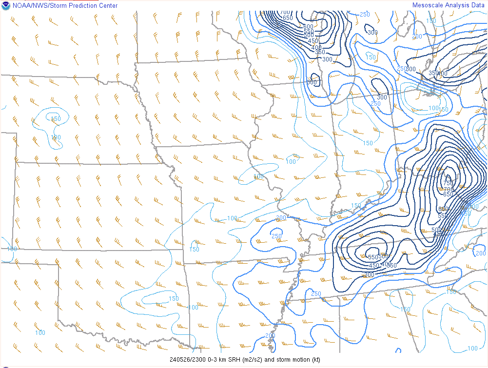
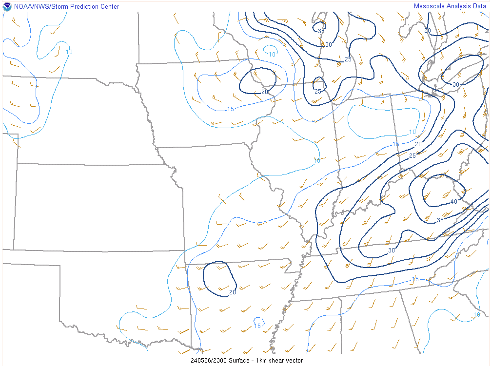
Effective bulk shear was greater than 50 kts across the region during the evening. The greatest low level shear and storm relative helicity was concentrated across western Kentucky, with lesser values further west. Mid-level lapse rates of 7.5 C/km were present, providing an ideal environment for large hail. Meanwhile, the downdraft CAPE was quite high, leading to an ideal environment for strong damaging winds to be transported to the surface.
 |
 |
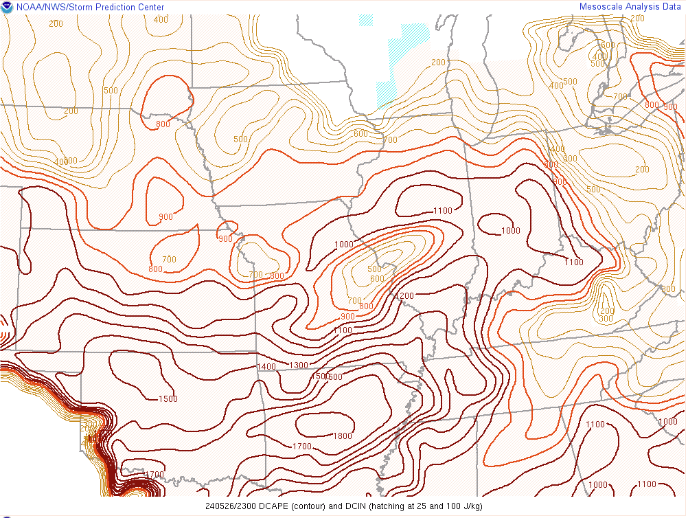 |
| 0-6km effective shear at 6 PM May 26, 2024 | Significant Tornado Parameter (STP) at 6 PM May 26, 2024 | Downdraft CAPE at 6 PM May 26, 2024 |
 |
 |
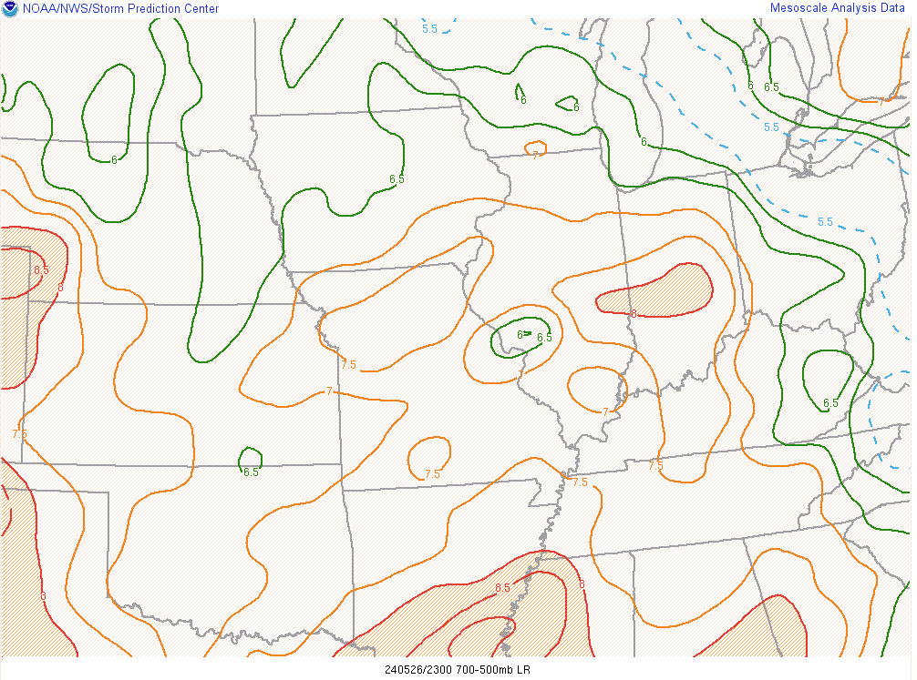 |
| 0-3km Storm Relative Helicity (SRH) at 6 PM May 26, 2024 | 0-1km shear at 6 PM May 26, 2024 | Mid-level Lapse Rates at 6 PM May 26, 2024 |
Additional Information
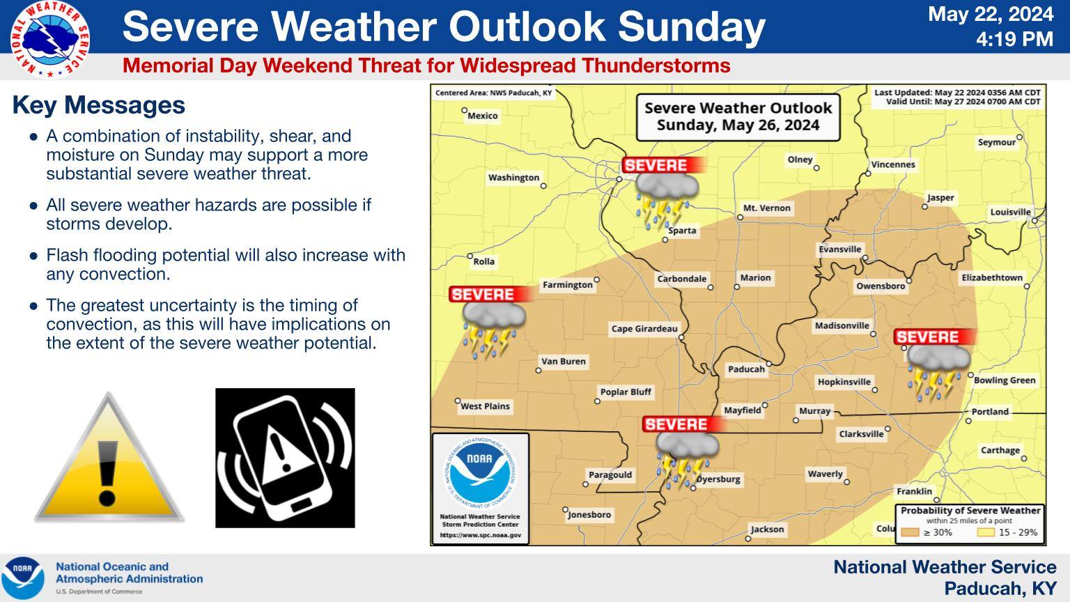
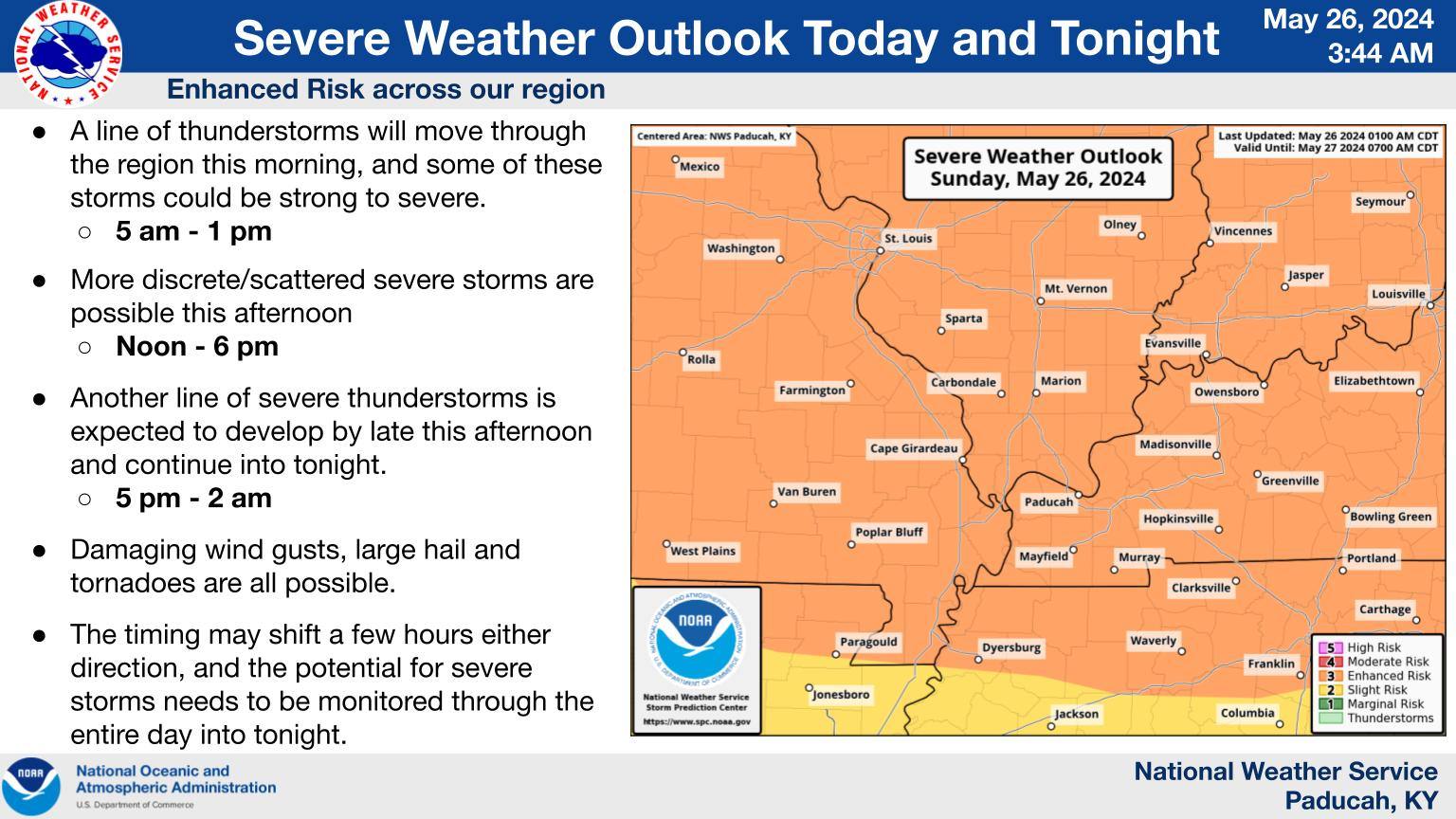
The Forecast
 |
 |
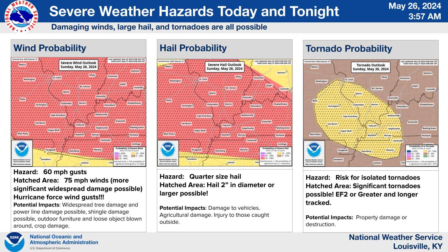 |
| Forecast issued 4 days before the event | Early AM Forecast on May 26th | SPC Hazards Graphics |
 |
Media use of NWS Web News Stories is encouraged! Please acknowledge the NWS as the source of any news information accessed from this site. |
|


.PNG)