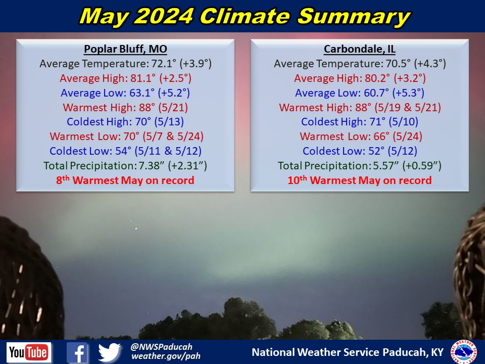
May 2024 Climate Review:
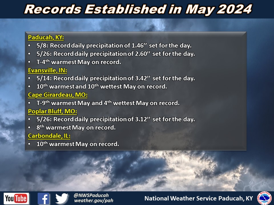
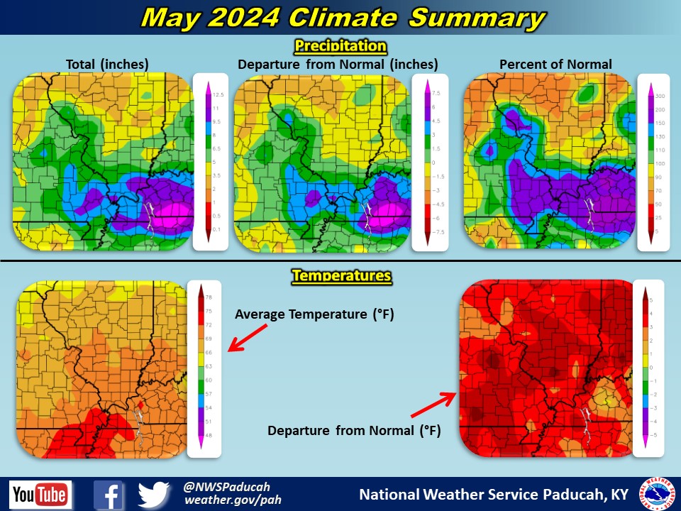
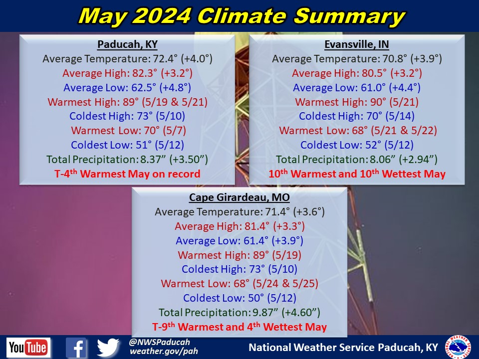
Temperatures were above normal by around 3 to 5 degrees. Paducah tied their 4th warmest May on record while Evansville observed their 10th warmest. The first 9 days of the month saw temperatures well above normal with highs in the 80s most days at most sites. The following week had near normal temperatures. Above normal temperatures returned for the 18th through the 27th. The month ended with slightly below normal temperatures. The warmest temperatures relative to normal were at the start of the month, while most locations had their warmest day of the month on the 19th or 21st.
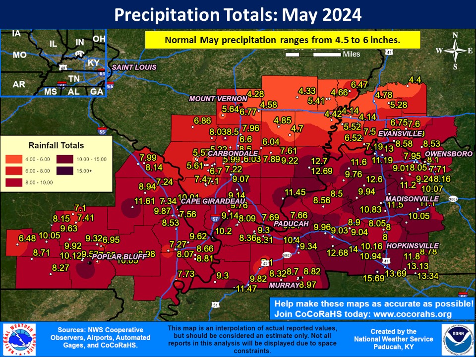
Precipitation was variable across the region. Locations near the I-64 corridor finished near normal, with around 4-7’’ of rainfall. Further south had a wetter than normal month, especially in Western Kentucky and far Southeast Illinois where double digit rainfall totals were commonplace for the month. The highest observed amount in our forecast area was 15.69” at a COOP station 5 miles S of Herndon, KY near the Tennessee border. The two heaviest rainfall events occurred with severe thunderstorm outbreaks on May 8th and 26th, both of which resulted in widespread flooding.
There were two historic severe weather events that impacted the region in May. The first occurred on May 8th when several rounds of storms occurred throughout a nearly 24 hour period beginning late evening on the 7th. The most widespread damage occurred during the afternoon and evening of the 8th as multiple bowing segments and several supercells occurred. 9 tornadoes touched down. Training storms resulted in flash flooding with rainfall totals of 2-4 inches in many areas, locally up to 5-6 inches. This event resulted in the single day record for most warning (SVR, TOR, FFW) issuances by the Paducah office of 117, shattering the old record of 71. The second severe weather event occurred on May 26th. Multiple rounds of severe thunderstorms occurred, the first being a bowing line crossing Southeast Missouri into Western Kentucky and far Southern Illinois from 5 to 10 AM, producing a wide swath of wind damage and several tornadoes. Supercells formed near sunset producing several more tornadoes while a line of storms moved across the Quad State from 7 to 11 PM, bringing a second round of widespread wind. At least 100,000 were without power across the Quad State region at the peak of this event. Flash flooding occurred with the morning and evening rounds of storms. So far, 14 tornadoes have been confirmed including 3 EF-3s. The May 26th event had the second highest single day warning issuance count in office history, only behind the May 8th record.
The graphic below is an interpolated monthly rainfall map using actual observations. Please note that there are likely discrepancies in between observations, since the values are estimated based on nearest reports.
| May 2024 Review: Precipitation and Temperature Maps (Click on image to enlarge) |
 |
| Climate Maps are from the Northeast Regional Climate Center |
Monthly Climate Report: Paducah | Evansville | Cape Girardeau | Poplar Bluff | Carbondale