Overview
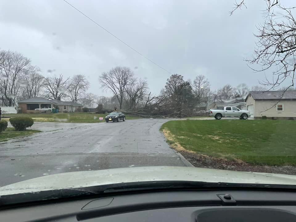
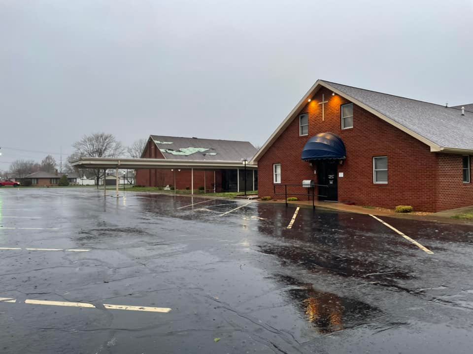
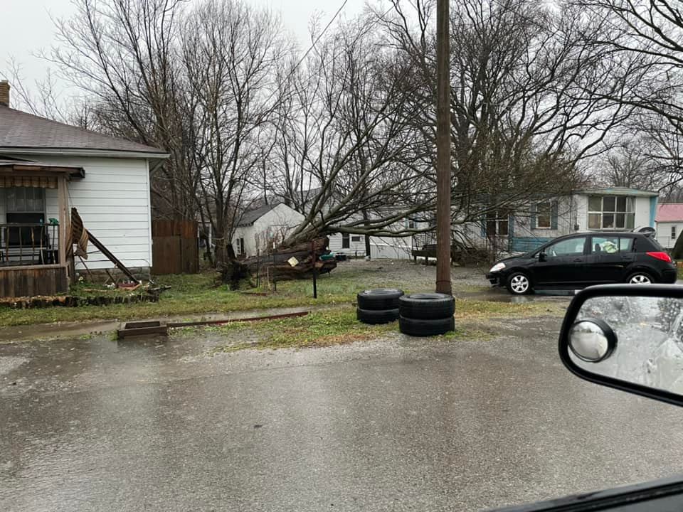
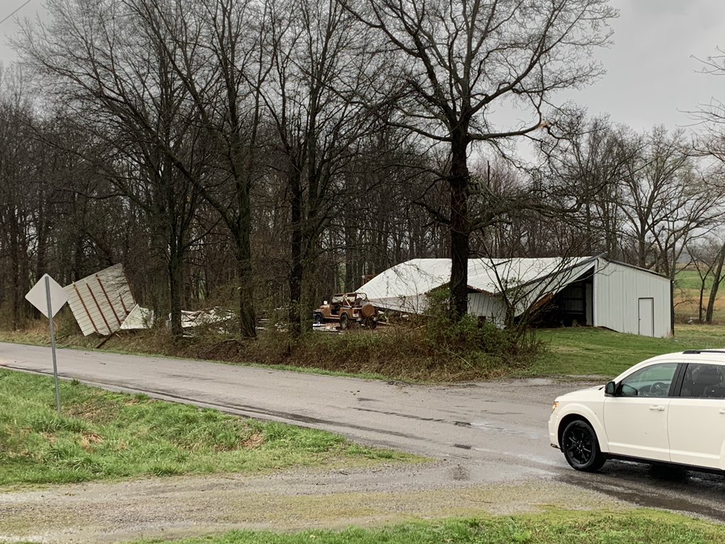
Strong gradient winds were observed across our region as surface low pressure deepened and moved north of the area. Wind gusts of 40 to 50 mph occurred through the day. During the afternoon, a line of thunderstorms formed from Arkansas into southeast Missouri and progressed eastward across the entire area into the early evening. This line produced scattered wind damage and minor flooding issues. Most locations received 1 to 2" of rain from this event, but there were some locally higher pockets over 2" in southeast Missouri and southern Illinois. Street flooding was most notable across Williamson County Illinois. Some power outages were observed as well including in the Paducah, Morganfield, and Henderson, KY areas as the line of storms moved through. There were 4 tornadoes that touched down in southern Illinois and southwest Indiana with this event, including an EF-1 that struck the town of Carmi.Tornadoes:
|
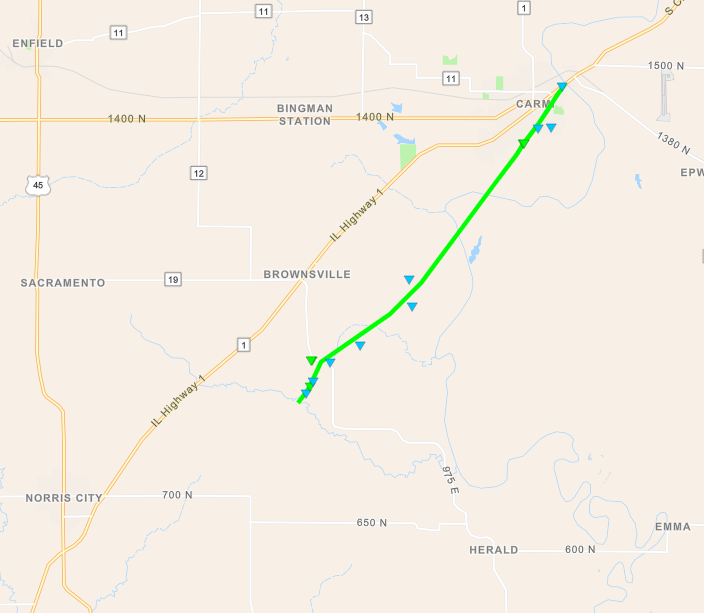
Tornado #1 - Carmi, Illinois
|
||||||||||||||||
|
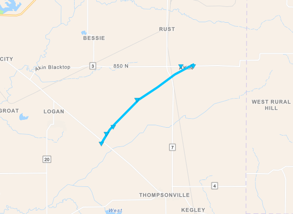
Tornado #2 - Akin, Illinois
|
||||||||||||||||
|
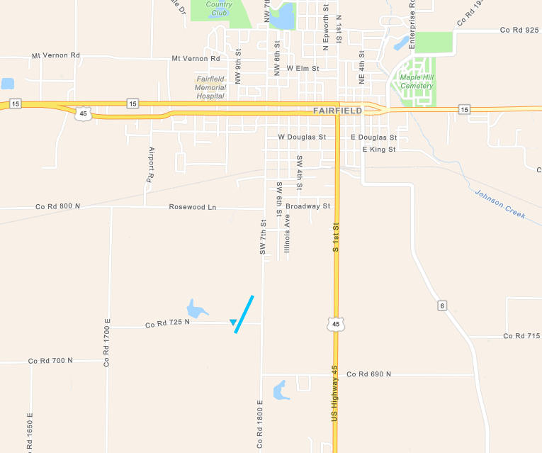
Tornado #3 - Fairfield, Illinois
|
||||||||||||||||
|
Tornado #4 - St. Wendel, Indiana
|
||||||||||||||||
The Enhanced Fujita (EF) Scale classifies tornadoes into the following categories:
| EF0 Weak 65-85 mph |
EF1 Moderate 86-110 mph |
EF2 Significant 111-135 mph |
EF3 Severe 136-165 mph |
EF4 Extreme 166-200 mph |
EF5 Catastrophic 200+ mph |
 |
|||||
Photos
 |
 |
 |
 |
| Damage in Carmi, IL via WROY/WRUL | Damage in Carmi, IL via WROY/WRUL | Damage in Carmi, IL via WROY/WRUL | Damage near Akin, IL via Derek Johnson |
Radar
Click here for a radar loop of this event.
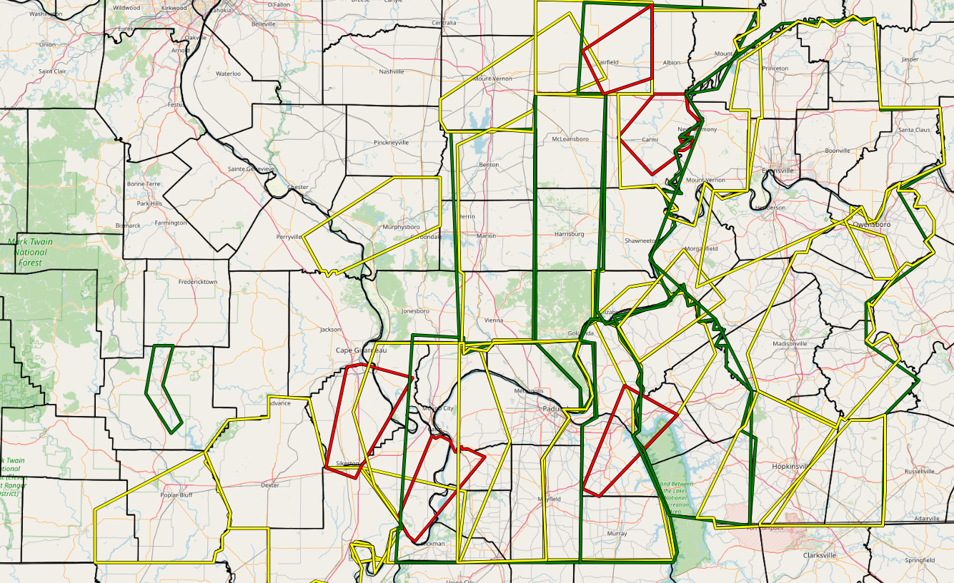
The graphic below displays all Severe Thunderstorm and Tornado Warnings issued during the event. It also shows all Flood Advisories that were issued.
Storm Reports
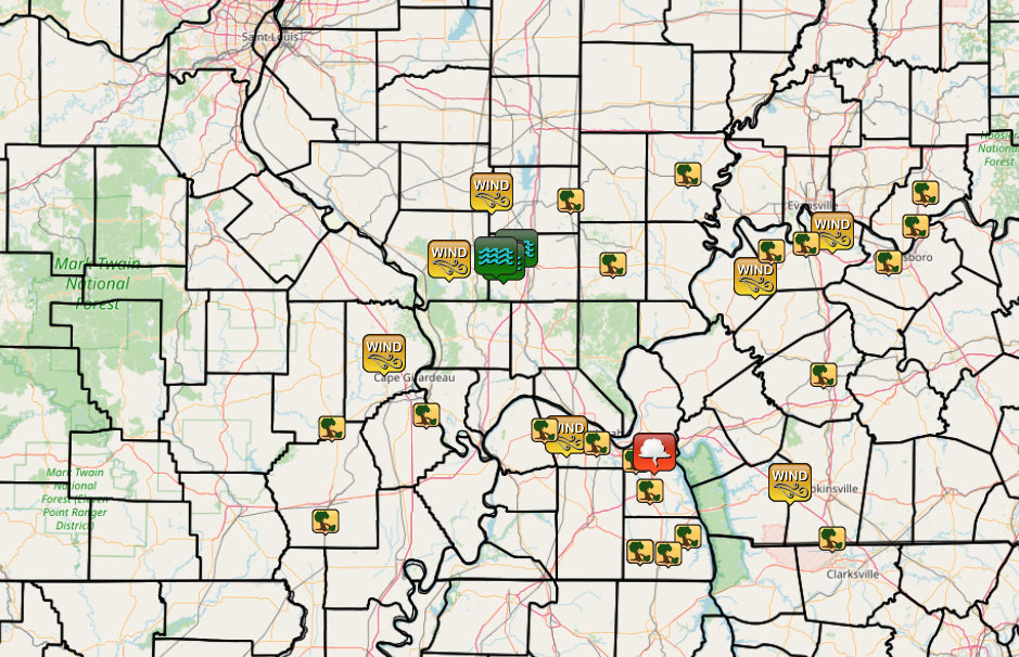 |
| Graphic above displays all Local Storm Reports issued during this event for the NWS Paducah area. |
PRELIMINARY LOCAL STORM REPORT...SUMMARY
NATIONAL WEATHER SERVICE PADUCAH KY
900 AM CDT THU MAR 31 2022

..TIME...   ...EVENT...      ...CITY LOCATION...     ...LAT.LON...
..DATE...   ....MAG....      ..COUNTY LOCATION..ST.. ...SOURCE....
            ..REMARKS..

1115 AM     NON-TSTM WND DMG 1 WNW JACKSON           37.39N 89.67W
03/30/2022                   CAPE GIRARDEAU     MO   PUBLIC

            WINDS IN EXCESS OF 40 MPH HAS CAUSED A FEW
            SHINGLES TO BE BLOWN OFF ROOF.

1119 AM     NON-TSTM WND GST 1 SW MURPHYSBORO        37.76N 89.35W
03/30/2022  E43 MPH          JACKSON            IL   PUBLIC

            TREE DOWN ON A HOUSE. MINIMAL DAMAGE TO
            STRUCTURE. POWER LINE WRAPPED ON TREE.

1128 AM     NON-TSTM WND DMG 5 W VALIER              38.02N 89.14W
03/30/2022                   FRANKLIN           IL   PUBLIC

            PUBLIC REPORT OF STRONG WIND GUSTS IN EXCESS
            OF 40 MPH RESULTING IN A POWER OUTAGE AND
            BLOWN TRANSFORMER IN VALIER, IL, JUST WEST
            OF BENTON, IL.

0335 PM     TSTM WND DMG     4 S DEXTER              36.73N 89.96W
03/30/2022                   STODDARD           MO   EMERGENCY MNGR

            TREE AND POWER LINES DOWN ON HWY D.

0345 PM     TSTM WND DMG     1 WSW ADVANCE           37.10N 89.93W
03/30/2022                   STODDARD           MO   EMERGENCY MNGR

            6 INCH TREE LIMB DOWN ON INDUSTRIAL DRIVE.

0420 PM     TSTM WND DMG     1 SW COMMERCE           37.15N 89.46W
03/30/2022                   SCOTT              MO   TRAINED SPOTTER

            TREE DAMAGE ON HWY E.

0459 PM     TSTM WND GST     2 SE HEATH              37.07N 88.77W
03/30/2022  M60 MPH          MCCRACKEN          KY   OFFICIAL NWS OBS


0510 PM     TSTM WND DMG     BENTON                  36.85N 88.36W
03/30/2022                   MARSHALL           KY   BROADCAST MEDIA

            SEVERAL TREES DOWN IN THE BENTON AREA.

0510 PM     TSTM WND DMG     KEVIL                   37.09N 88.88W
03/30/2022                   BALLARD            KY   BROADCAST MEDIA

            TREES DOWN IN KEVIL.

0510 PM     TSTM WND DMG     6 ESE REIDLAND          36.97N 88.43W
03/30/2022                   MARSHALL           KY   EMERGENCY MNGR

            POWER POLE DOWN AT INTERSECTION OF MT.
            MARIAH RD AND US68 WEST.

0515 PM     FLOOD            1 E HERRIN              37.80N 89.02W
03/30/2022                   WILLIAMSON         IL   FIRE DEPT/RESCUE

            8 INCHES OF WATER ON 8TH STREET.

0520 PM     FUNNEL CLOUD     2 SSE CALVERT CITY      37.00N 88.34W
03/30/2022                   MARSHALL           KY   PUBLIC

            LATE REPORT. SEVERAL REPORTS OF FUNNEL CLOUD
            NEAR CALVERT CITY.

0523 PM     NON-TSTM WND DMG 3 WNW SPOTTSVILLE       37.87N 87.46W
03/30/2022                   HENDERSON          KY   FIRE DEPT/RESCUE

            TREE ON POWER LINE, POWER OUTAGE.

0525 PM     TSTM WND DMG     2 SSE PADUCAH           37.04N 88.62W
03/30/2022                   MCCRACKEN          KY   UTILITY COMPANY

            APPROXIMATELY 975 CUSTOMERS WITHOUT POWER IN
            PADUCAH.

0530 PM     TSTM WND DMG     5 ENE HANAFORD          37.99N 88.75W
03/30/2022                   FRANKLIN           IL   EMERGENCY MNGR

            ROOF AND SIDING DAMAGE TO HOMES IN AKIN.
            ALSO, TWO OUT-BUILDINGS COMPLETELY DAMAGED.

0536 PM     NON-TSTM WND GST GRACEY                  36.88N 87.67W
03/30/2022  M60 MPH          CHRISTIAN          KY   STORM CHASER


0538 PM     FLOOD            CARTERVILLE             37.76N 89.08W
03/30/2022                   WILLIAMSON         IL   PUBLIC

            6 TO 8 INCHES OF WATER ON SOME ROADS.

0550 PM     TSTM WND DMG     HARRISBURG              37.74N 88.54W
03/30/2022                   SALINE             IL   911 CALL CENTER

            TREE AND POWER LINES DOWN ON HOUSE.

0550 PM     FLOOD            1 WSW CRAINVILLE        37.75N 89.08W
03/30/2022                   WILLIAMSON         IL   TRAINED SPOTTER

            6 INCHES WATER ON THE ROAD.

0555 PM     TSTM WND DMG     7 NW HAMLIN             36.67N 88.17W
03/30/2022                   CALLOWAY           KY   PUBLIC

            TREES DOWN ON FAXON ROAD.

0601 PM     FLOOD            1 SSW CAMBRIA           37.77N 89.12W
03/30/2022                   WILLIAMSON         IL   TRAINED SPOTTER

            4 INCHES OF WATER ON THE ROAD.

0605 PM     TSTM WND DMG     2 NE LYNN GROVE         36.61N 88.41W
03/30/2022                   CALLOWAY           KY   PUBLIC

            CORRECTS PREVIOUS TSTM WND DMG REPORT FROM 2
            NE LYNN GROVE. TREES DOWN ON THURMAN ROAD.

0612 PM     TSTM WND DMG     3 ESE MURRAY            36.60N 88.27W
03/30/2022                   CALLOWAY           KY   PUBLIC

            TREES DOWN ON OLD SALEM ROAD.

0620 PM     TSTM WND DMG     CARMI                   38.09N 88.17W
03/30/2022                   WHITE              IL   911 CALL CENTER

            LOTS OF TREES DOWN ACROSS THE AREA.

0632 PM     TSTM WND GST     1 WNW GRACEY            36.88N 87.67W
03/30/2022  M75 MPH          TRIGG              KY   TRAINED SPOTTER


0640 PM     TSTM WND GST     1 ENE BRECKINRIDGE CENT 37.69N 87.84W
03/30/2022  M73 MPH          UNION              KY   MESONET

            MESONET STATION FRNY MORGANFIELD KY 4 E.

0648 PM     TSTM WND DMG     2 SSE MADISONVILLE      37.31N 87.50W
03/30/2022                   HOPKINS            KY   PUBLIC

            LARGE TREE LIMBS DOWN, HIGH WINDS.

0652 PM     TSTM WND DMG     5 NW CORYDON            37.79N 87.76W
03/30/2022                   HENDERSON          KY   FIRE DEPT/RESCUE

            TREE BLOCKING ROAD.

0710 PM     TSTM WND DMG     3 W OWENSBORO           37.75N 87.18W
03/30/2022                   DAVIESS            KY   FIRE DEPT/RESCUE

            TREE DOWN ALONG HWY 56.

0715 PM     TSTM WND DMG     HENDERSON               37.82N 87.59W
03/30/2022                   HENDERSON          KY   UTILITY COMPANY

            2100 CUSTOMERS WITHOUT POWER IN HENDERSON
            COUNTY.

0717 PM     TSTM WND DMG     ROCKPORT                37.89N 87.05W
03/30/2022                   SPENCER            IN   EMERGENCY MNGR

            TREE DOWN ON POWER LINE.

0725 PM     TSTM WND DMG     2 E CHRISNEY            38.02N 87.00W
03/30/2022                   SPENCER            IN   EMERGENCY MNGR

            3 UTILITY POLES SNAPPED NEAR 900 NORTH AND
            ORCHARD RD.

0804 PM     TSTM WND DMG     1 NNE FORT CAMPBELL NOR 36.66N 87.46W
03/30/2022                   CHRISTIAN          KY   PUBLIC

            LARGE TREE LIMBS DOWN.
Strong Gradient Winds
Ahead of the line of thunderstorms, strong gradient winds occurred during the morning and afternoon on March 30. Most locations observed 40 to 50 mph wind gusts. This resulted in some minor damage along with a few intermittent power outages across the region.
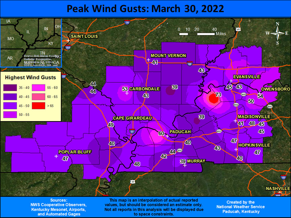
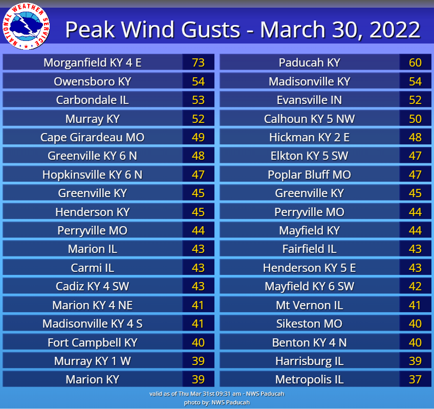
The graphic below displays the maximum peak wind gusts from ASOS, AWOS, and KYMN stations across our region during the entire day on March 30. Most of these were non-thunderstorm wind gusts ahead of the line of storms. However, the 60 mph gust at Paducah and 73 mph gust in Morganfield, KY (Union County) were with the thunderstorm line.
 |
 |
 |
Media use of NWS Web News Stories is encouraged! Please acknowledge the NWS as the source of any news information accessed from this site. |
|


.PNG)