Overview
|
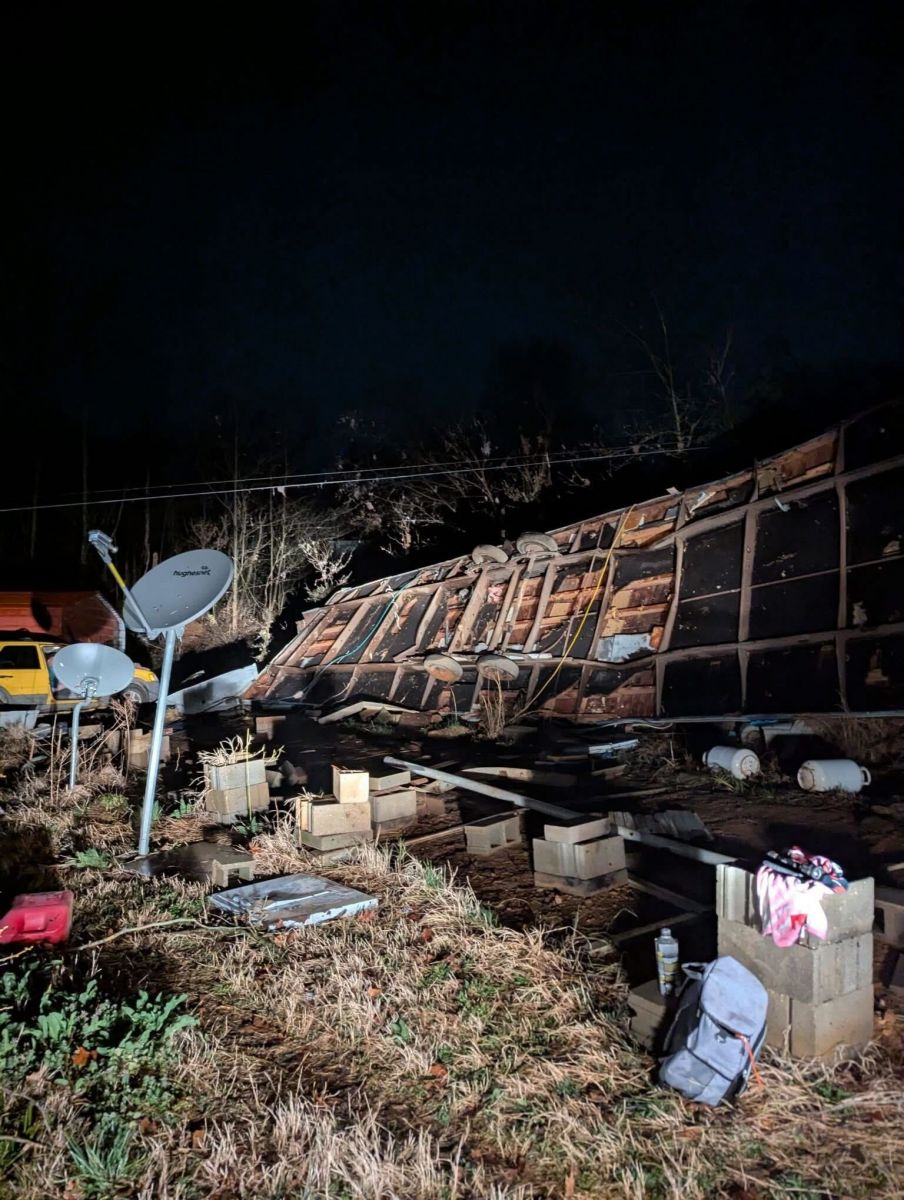
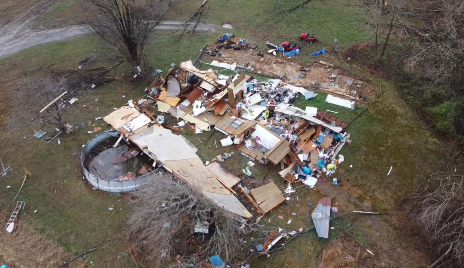
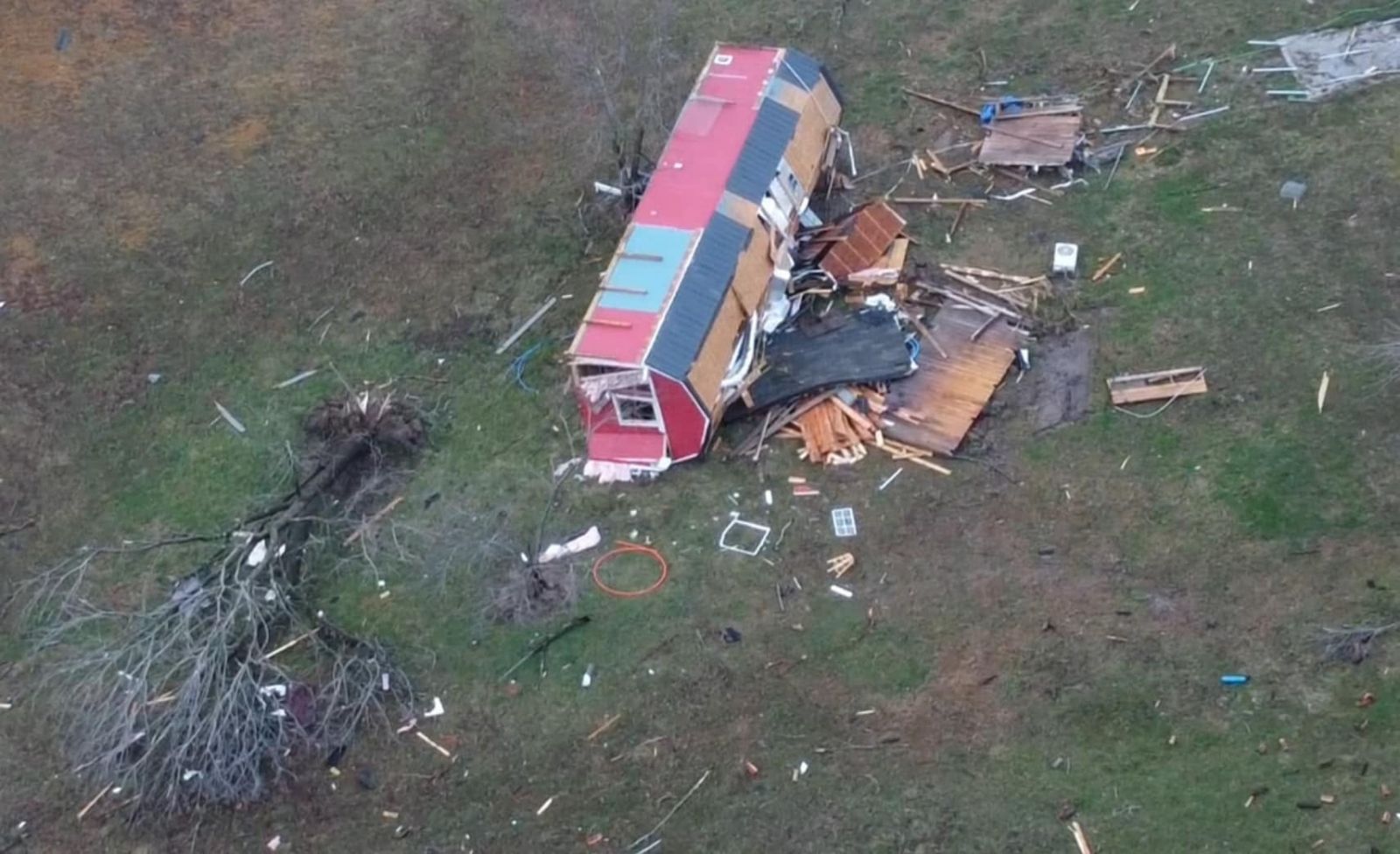
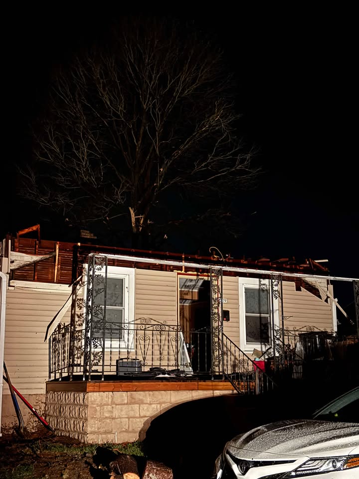
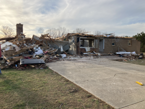
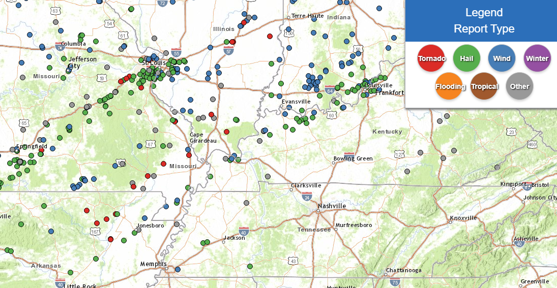
A potent late winter/early spring storm system brought widespread severe thunderstorms to the Mid Mississippi River valley starting late on Friday, March 14th, continuing into the overnight hours early Saturday, March 15th. These fast moving storms produced a variety of hazards, including several tornadoes, damaging winds, and sporadic large hail. Large hail damaged windows, siding, roofs, and vehicles in many communities, with the hardest hit being Owensboro. Numerous areas were impacted by damage to homes, machine sheds, power lines, and trees as well. A total of 13 tornadoes have been confirmed by NWS Paducah with this outbreak. This includes six EF-3 tornadoes, five EF-2 tornadoes, and two EF-1 tornadoes. A total of seven lives were claimed by these tornadoes in addition to 12 injuries.
|
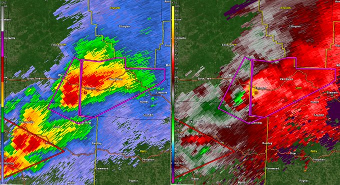
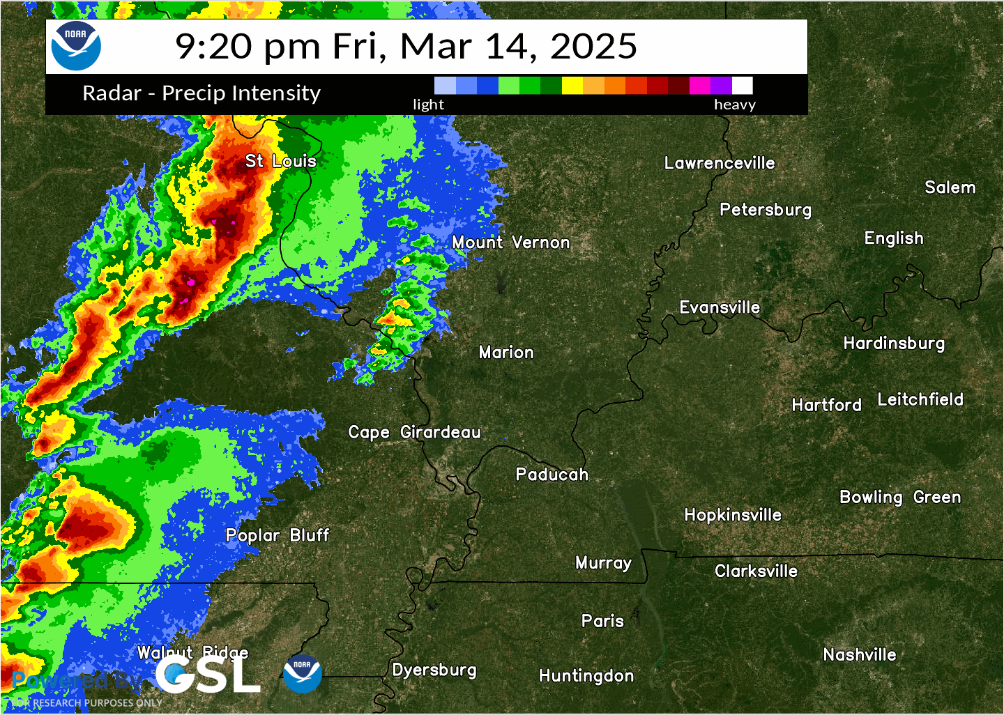 Radar loop from Friday evening (March 14th) into early Saturday morning (March 15th) |
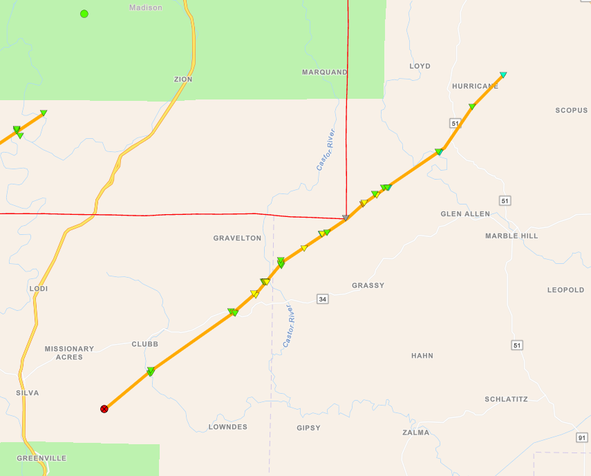
Tornadoes:
|
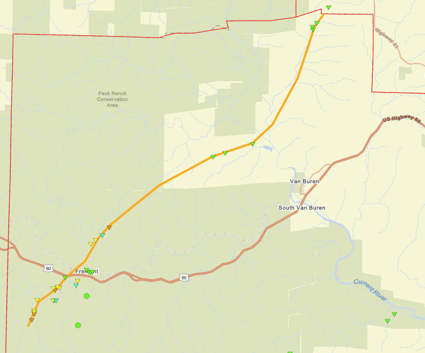
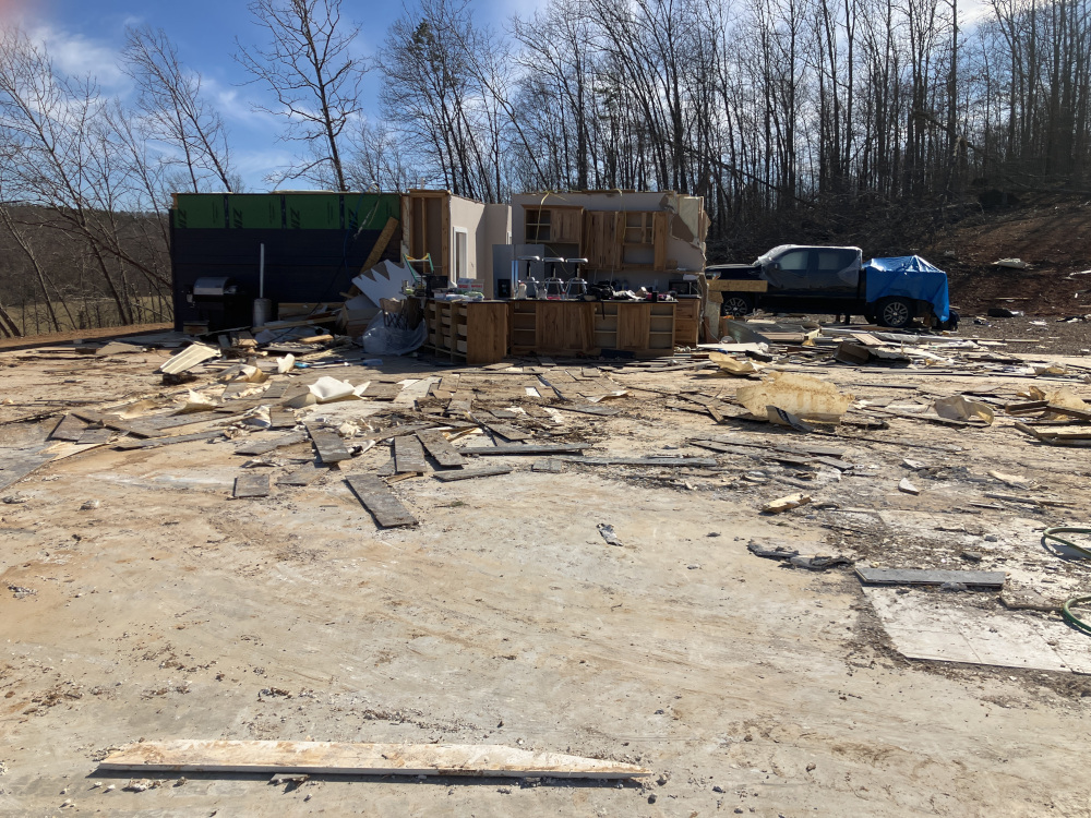
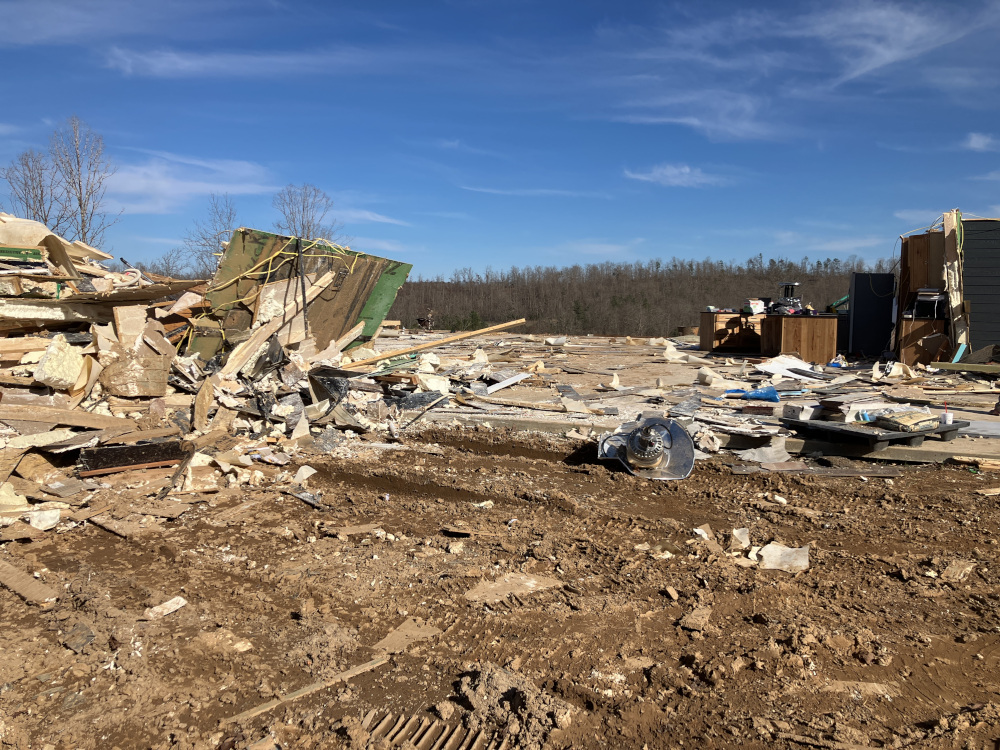
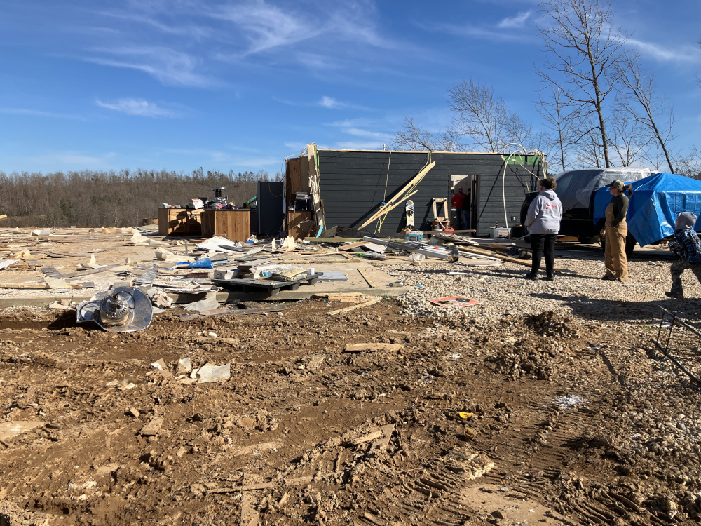
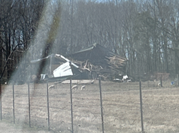
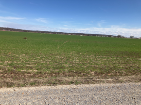
Tornado #1 - Fremont, MO
|
||||||||||||||||
|
||||||||||||||||
|
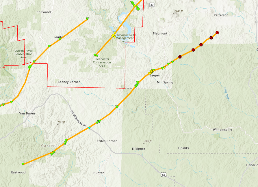
Tornado #2 - Leeper, MO
|
||||||||||||||||
|
||||||||||||||||
|
Tornado #3 - Gads Hill, MO
|
||||||||||||||||
|
||||||||||||||||
|
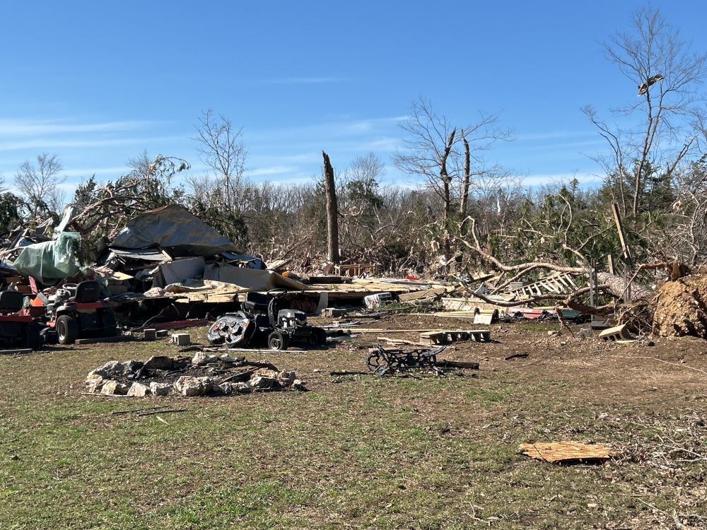
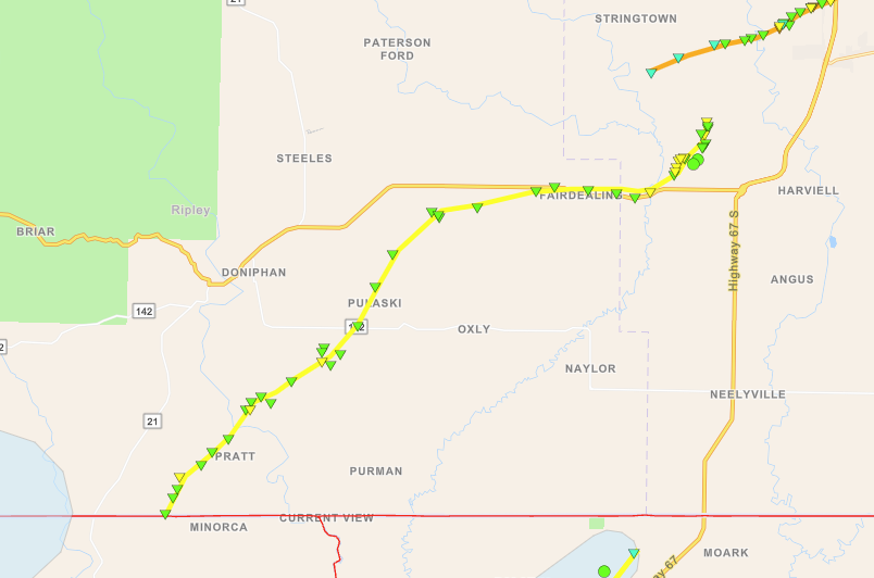
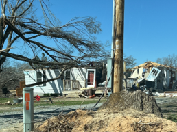
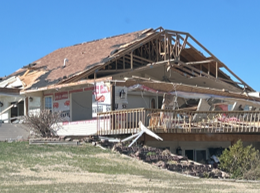
Tornado #4 - Fairdealing, MO
|
||||||||||||||||
|
||||||||||||||||
|
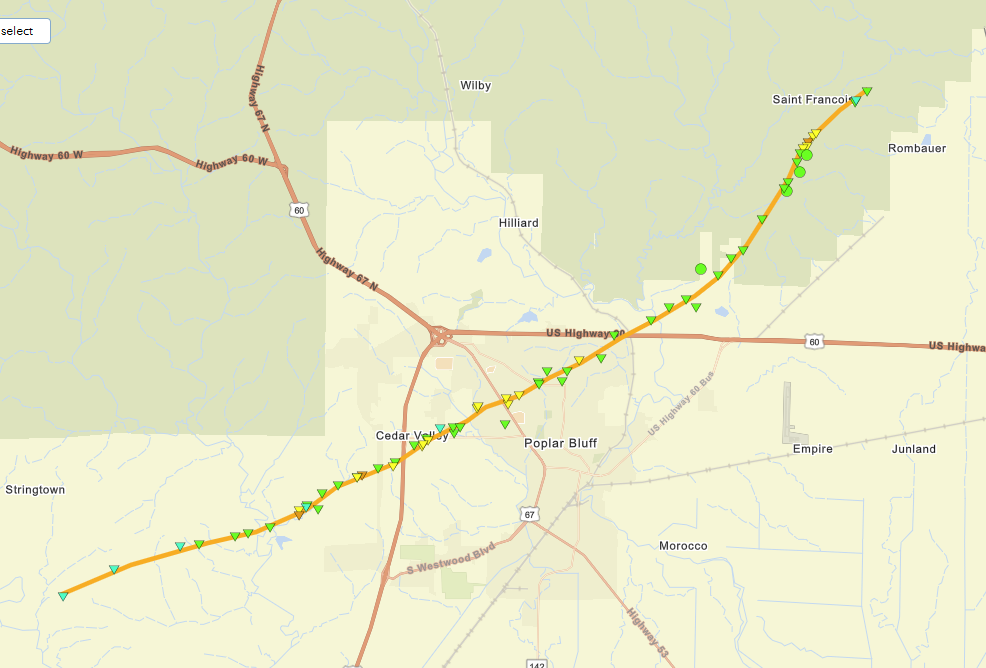
Tornado #5 - Poplar Bluff, MO
|
||||||||||||||||
|
||||||||||||||||
|
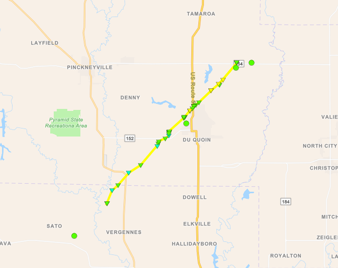
Tornado #6 - DuQuoin/St.Johns, IL
|
||||||||||||||||
|
||||||||||||||||
|
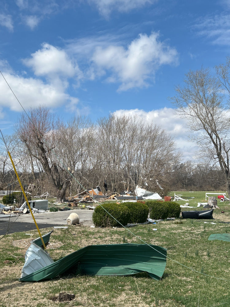
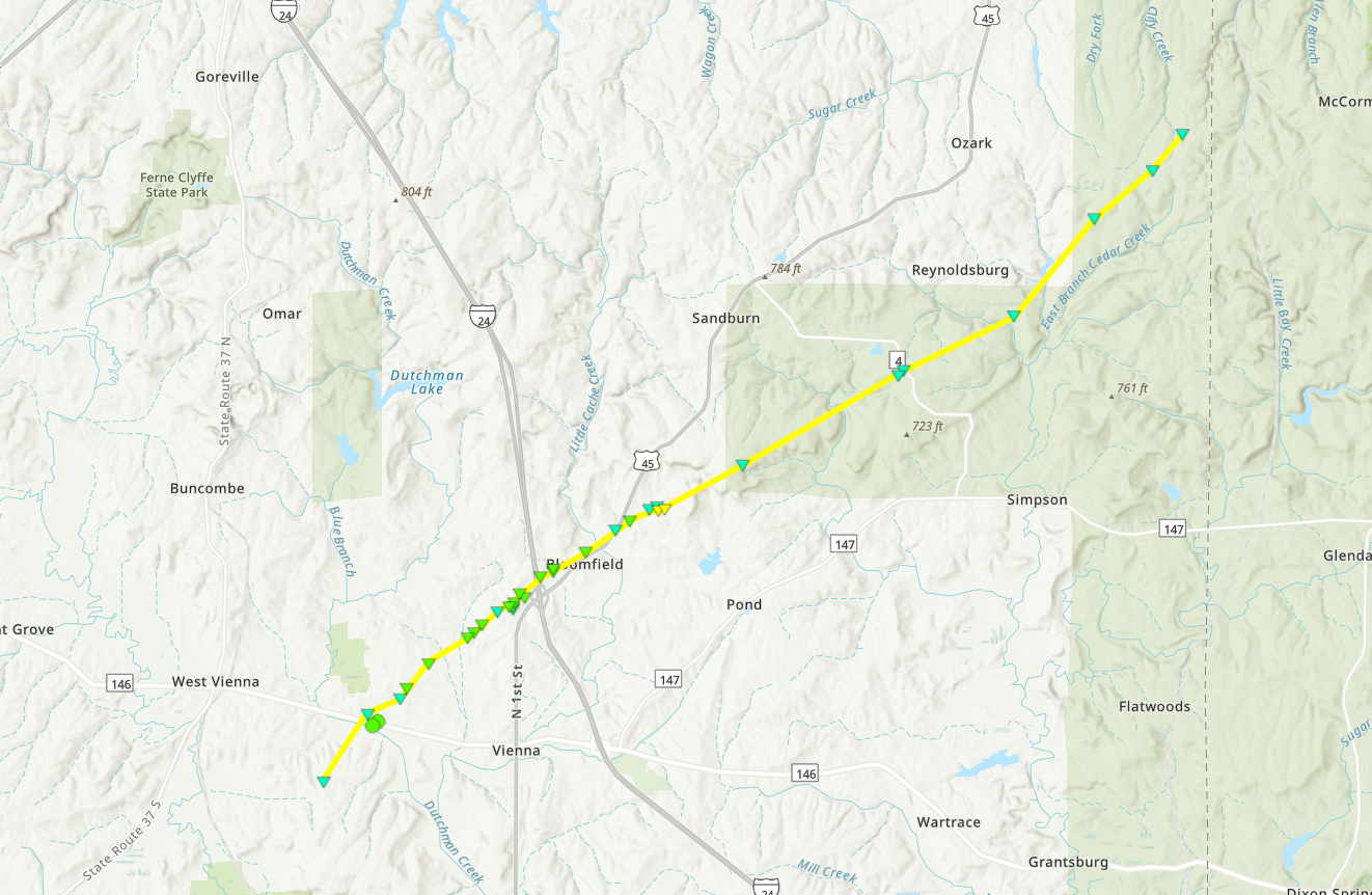
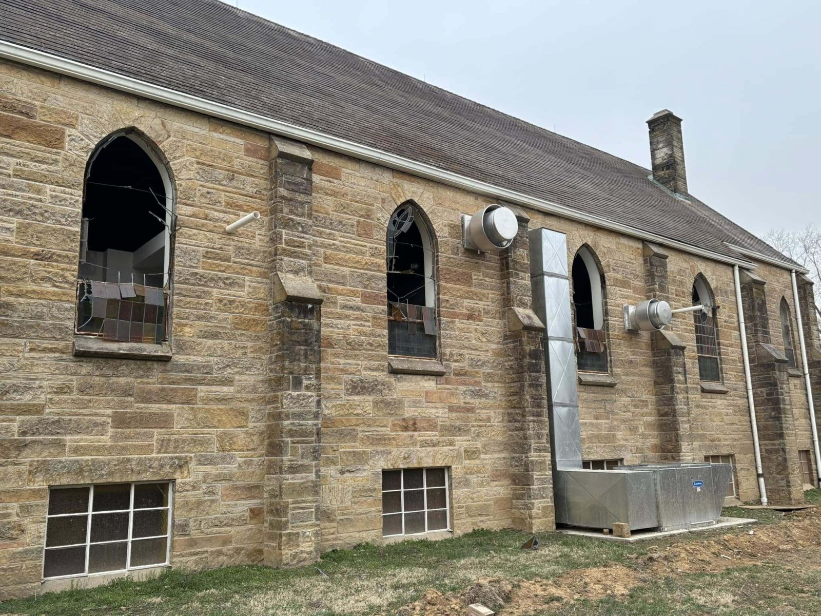
Tornado #7 - Vienna, IL
|
||||||||||||||||
|
||||||||||||||||
|
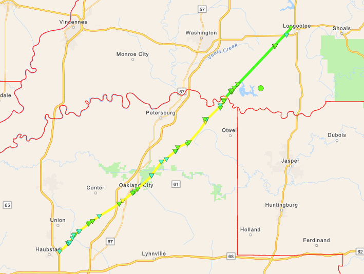
Tornado #8 - Oakland City, IN
|
||||||||||||||||
|
||||||||||||||||
|
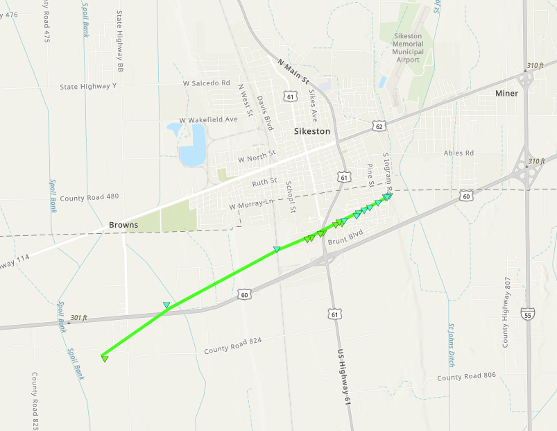
Tornado #9 - Sikeston, Missouri
|
||||||||||||||||
|
||||||||||||||||
|
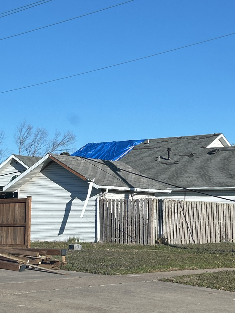
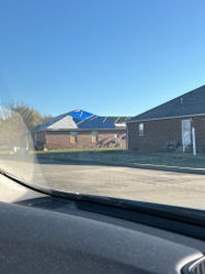
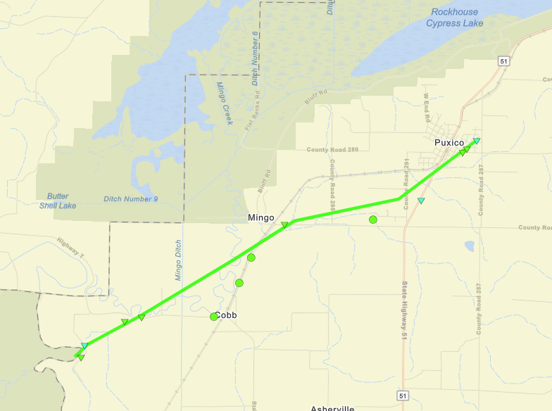
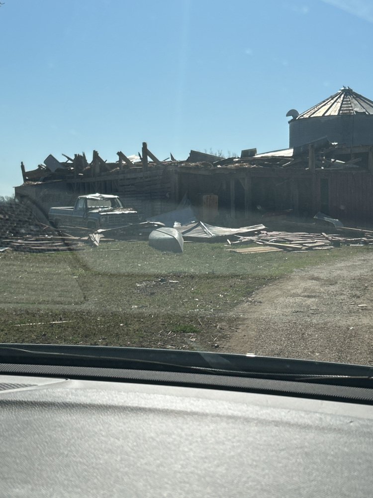
Tornado #10 - Puxico, Missouri
|
||||||||||||||||
|
||||||||||||||||
|
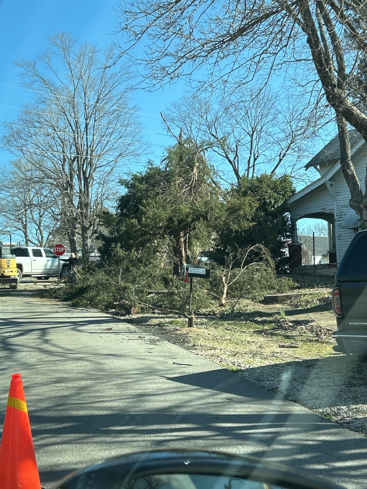
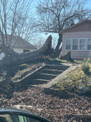
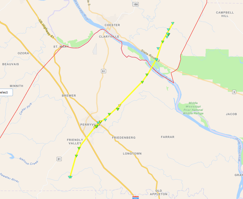
Tornado #11 - Perryville, Missouri
|
||||||||||||||||
|
||||||||||||||||
|
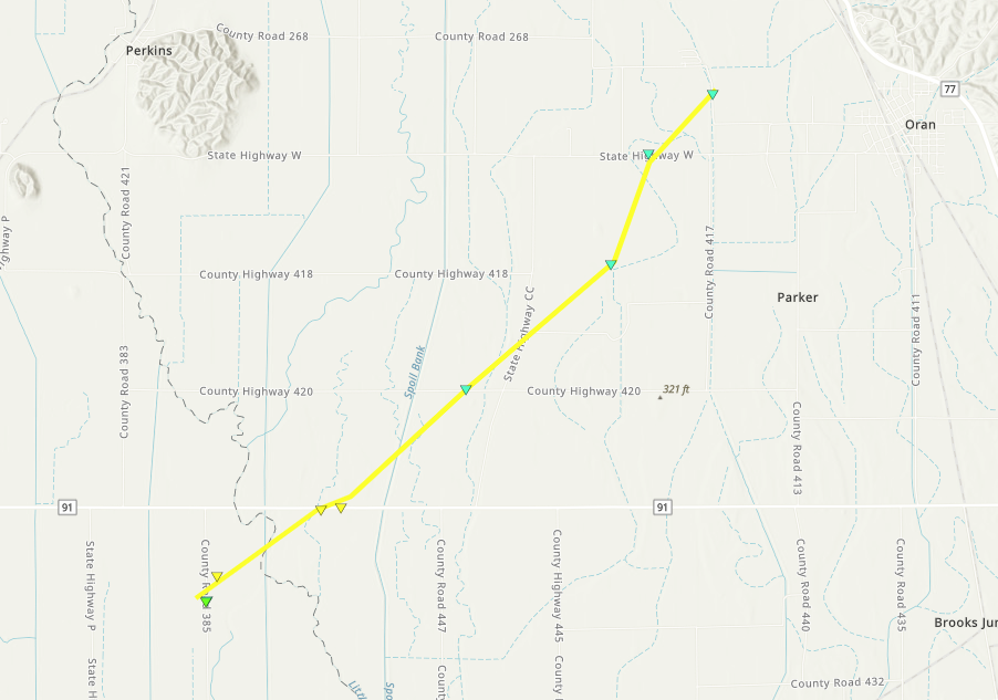
Tornado #12 - Oran, Missouri
|
||||||||||||||||
|
||||||||||||||||
|
Tornado #13 - Greenville/Sedgewickville, Missouri
|
||||||||||||||||
|
||||||||||||||||
|
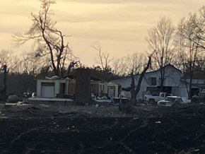
Tornado #14 - Aid, Missouri
|
||||||||||||||||
|
||||||||||||||||
The Enhanced Fujita (EF) Scale classifies tornadoes into the following categories:
| EF0 Weak 65-85 mph |
EF1 Moderate 86-110 mph |
EF2 Significant 111-135 mph |
EF3 Severe 136-165 mph |
EF4 Extreme 166-200 mph |
EF5 Catastrophic 200+ mph |
 |
|||||
Wind & Hail:
Wind
In addition to the damage caused by tornadoes, many supercell thunderstorm produced powerful downburst winds of 80 to 100 mph, which caused extensive tree damage and damage to homes and outbuildings.
 |
 |
 |
 |
| Perry County, Missouri (NWS Survey) | Perry County, Missouri (NWS Survey) | Vienna, Illinois (NWS Survey) | Poplar Bluff, Missouri (NWS Survey) |
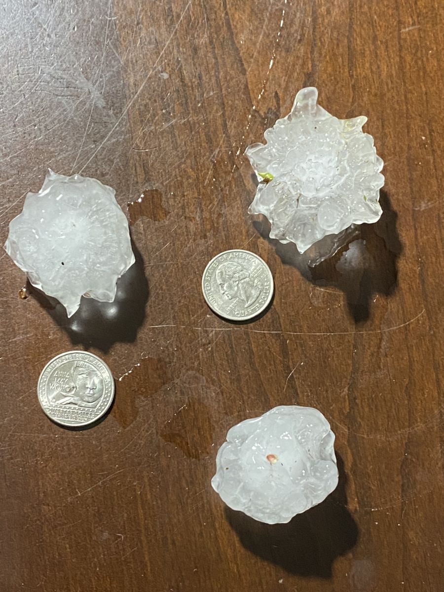
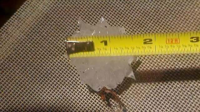
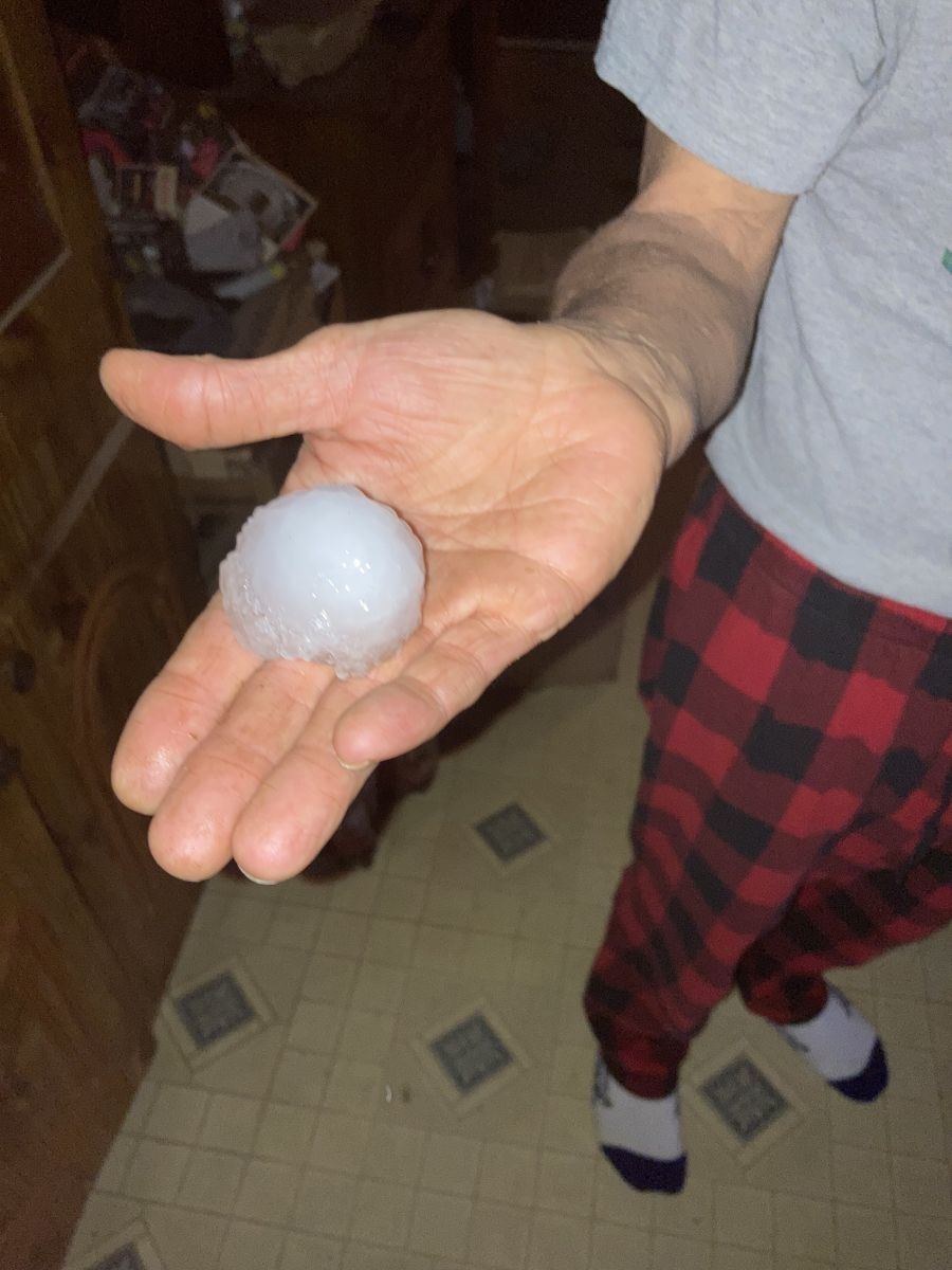
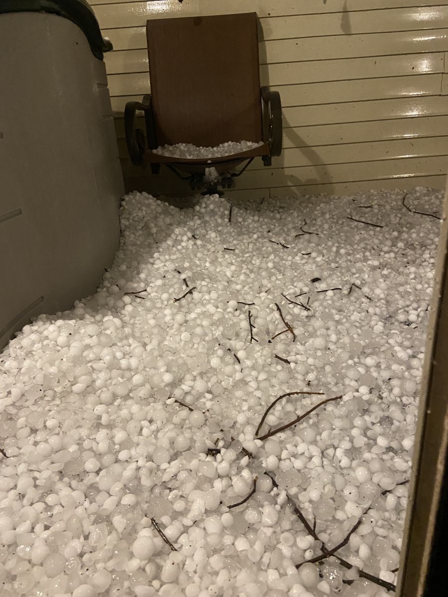
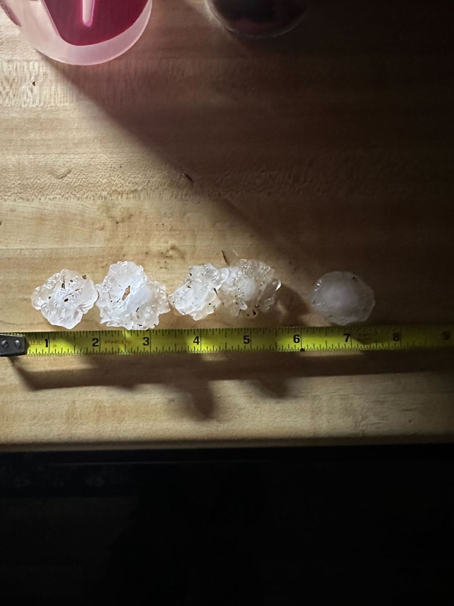
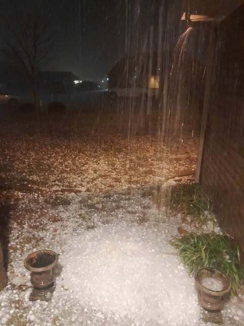
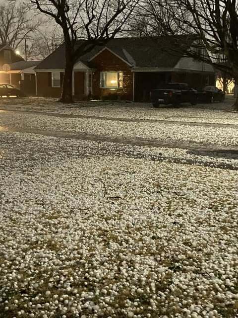
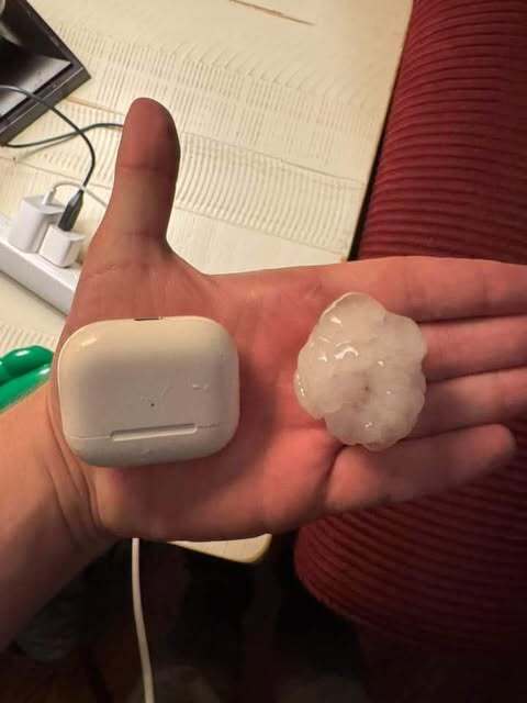
Hail
Many of the supercell thunderstorm that produced tornadoes also generated large hail of 1 to 1.75 inches in diameter.
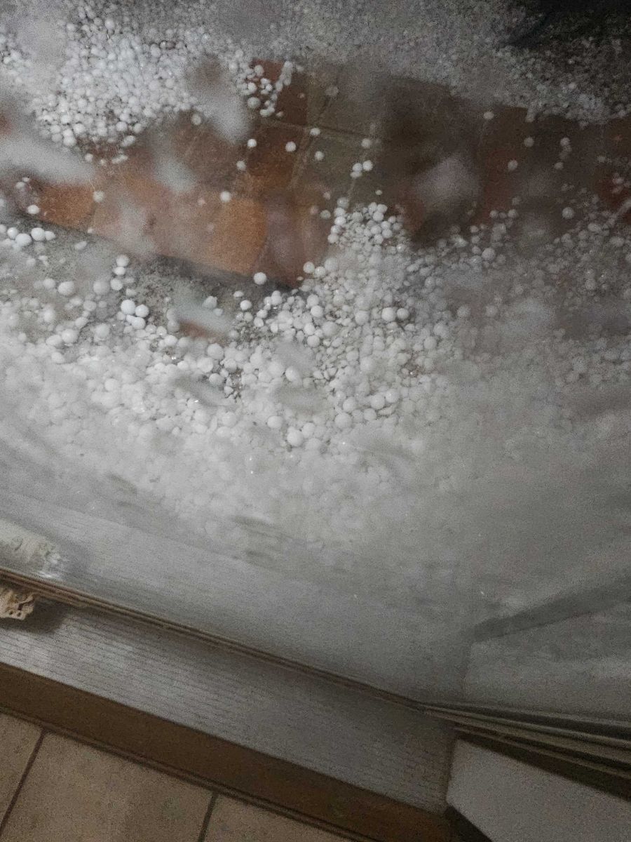
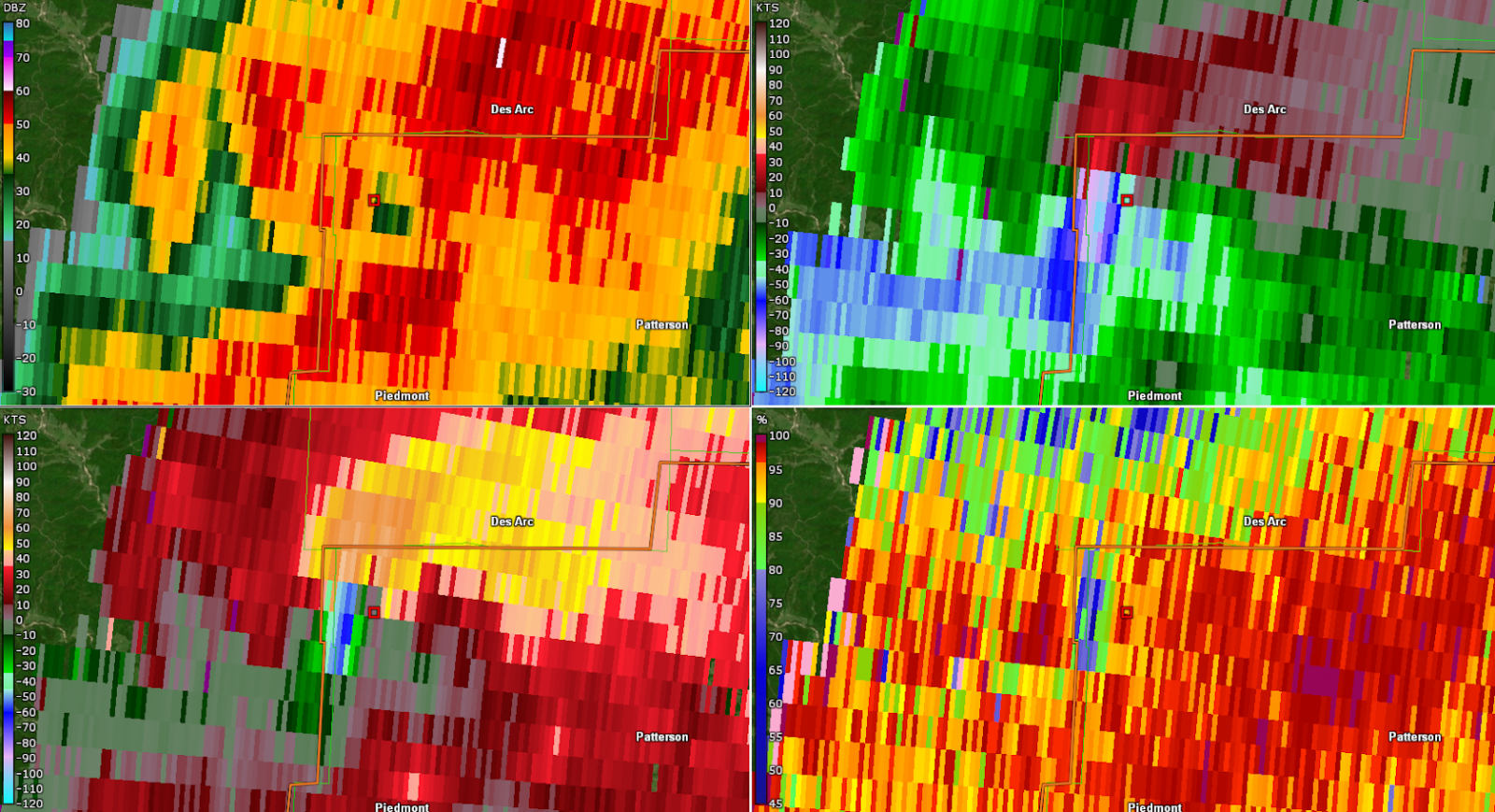
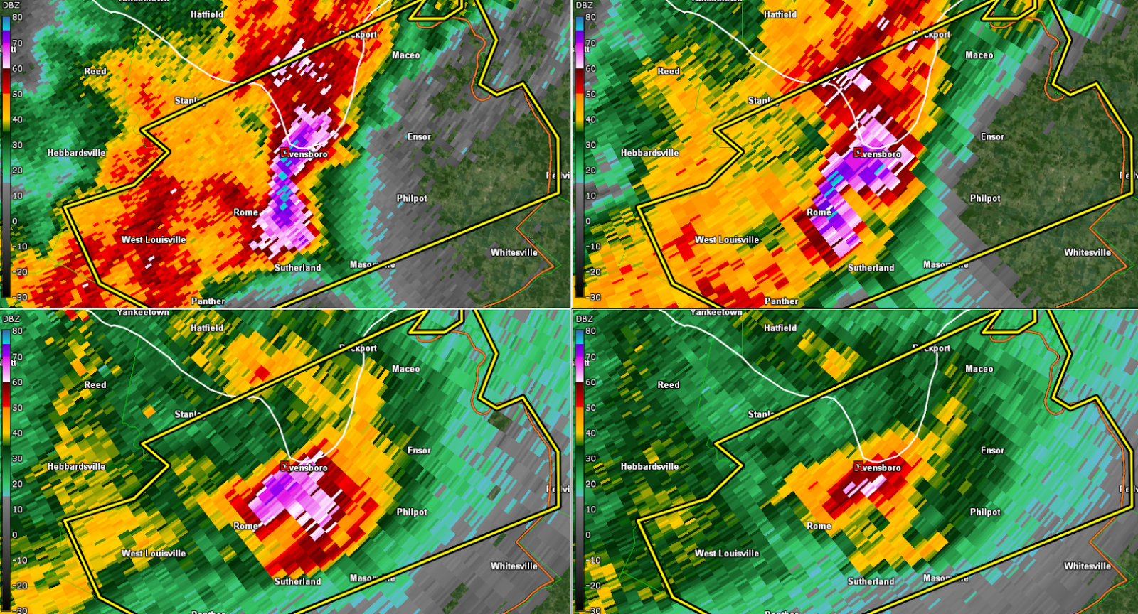
However, one supercell that impacted the Owensboro, Kentucky, area produce hail of tennis (2.5 inches) to baseball size
(2.75 inches). Driven by strong thunderstorm winds, this hail produced extensive damage across Owensboro and Daviess County,
Kentucky, including destroying siding on homes, breaking windows, and damaging vehicles. See the Photos page for pictures of
the hail and the damage it caused.
Preliminary Local Storm Report
National Weather Service Paducah KY
834 AM CDT Sat Mar 15 2025
..TIME... ...EVENT... ...CITY LOCATION... ...LAT.LON...
..DATE... ....MAG.... ..COUNTY LOCATION..ST.. ...SOURCE....
..REMARKS..
0458 AM Hail 4 E Owensboro 37.76N 87.05W
03/15/2025 M2.50 Inch Daviess KY Public
Report from mPING of Tennis Ball (2.50 in.)
hail.
0458 AM Hail 2 SW Owensboro 37.73N 87.14W
03/15/2025 E2.00 Inch Daviess KY Public
Report from mPING of Hen Egg (2.00 in.)
hail.
0357 AM Hail 3 NE Sebree 37.62N 87.48W
03/15/2025 E1.75 Inch McLean KY Public
Report from mPING of Golf Ball (1.75 in.)
hail.
0456 AM Hail 2 E Owensboro 37.75N 87.08W
03/15/2025 E1.75 Inch Daviess KY Public
Report from mPING of Golf Ball (1.75 in.)
hail.
0513 AM Hail 5 NW Pellville 37.78N 86.89W
03/15/2025 E1.50 Inch Daviess KY Public
Report from mPING of Ping Pong Ball (1.50
in.) hail.
0140 AM Hail 1 E Howardville 36.57N 89.58W
03/15/2025 E1.25 Inch New Madrid MO Public
Report from mPING of Half Dollar (1.25 in.)
hail.
0146 AM Hail 1 SE Harrisburg 37.73N 88.53W
03/15/2025 E1.25 Inch Saline IL Public
Report from mPING of Half Dollar (1.25 in.)
hail.
0241 AM Hail 1 S Poseyville 38.16N 87.78W
03/15/2025 E1.00 Inch Posey IN Public
Report from mPING of Quarter (1.00 in.)
hail.
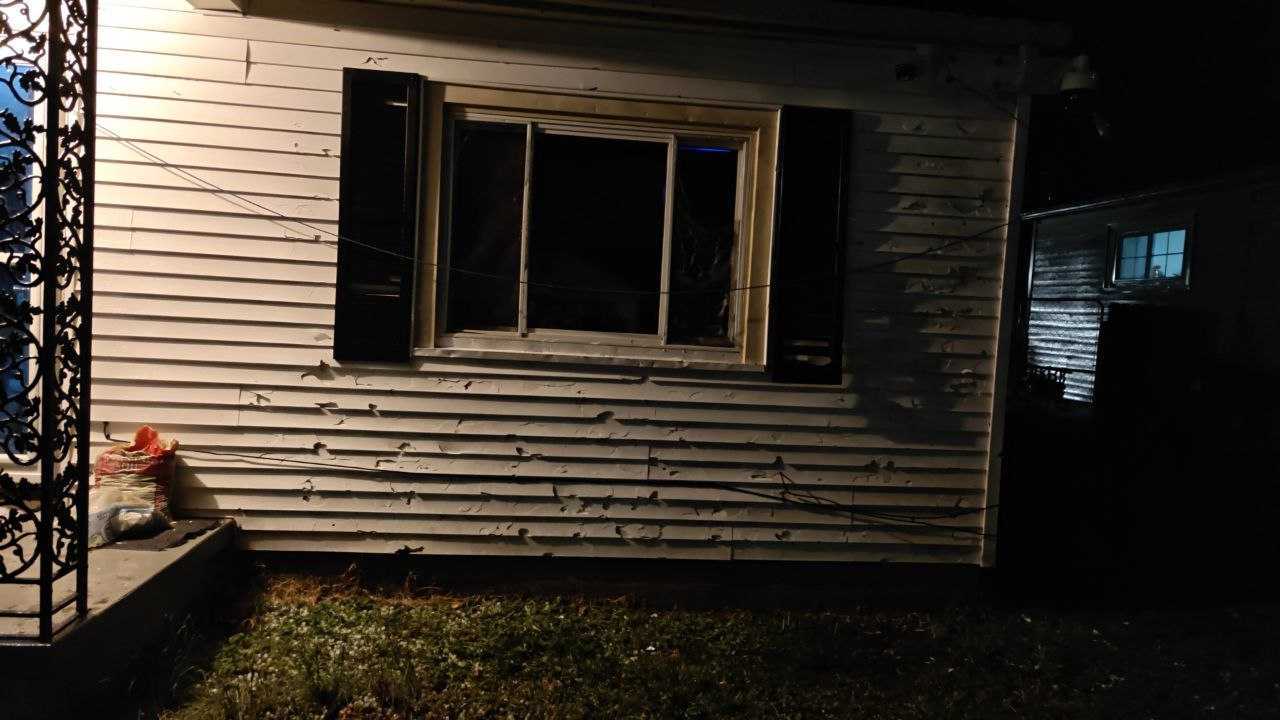
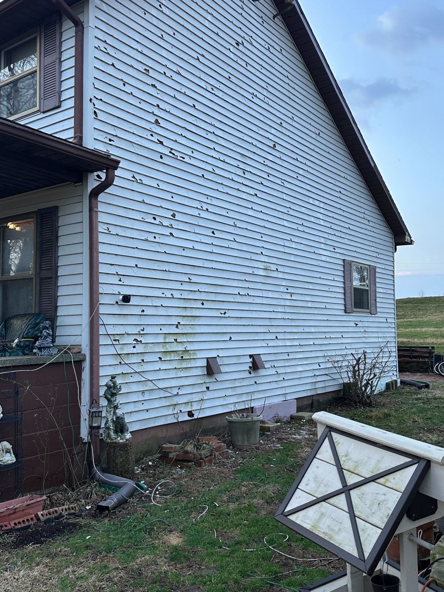
Photos:
Large Hail
 |
 |
 |
 |
| Hail in Owensboro, KY (Photo by Linsday Stone) |
Hail damage in Owensboro, KY (Photo by Yancy Smith) |
Hail damage in St Joseph, KY (Photo by Danny Thompson) |
Hail in Owensboro, KY (Photo by Arden Gregory) |
 |
 |
 |
 |
| Hail in Owensboro, KY (Photo by Chris Crabtree) |
Hail in Sorgho, KY (Photo by Arden Gregory) |
Hail in Owensboro, KY (Photo by Arden Gregory) |
Hail in Ledbetter, KY (Photo by Amanda Raether) |
 |
 |
 |
 |
| Hail in Poverty, KY (Photo by Jimmy VanCleve) |
Hail in Sorgho, KY (Photo by Tim Crabtree) |
Hail in Owensboro, KY (Photo by Mandy Stinnett) |
Hail damage in Owensboro, KY (Photo by Arden Gregory) |
 |
 |
 |
 |
| Hail in Owensboro, KY (Photo by Mandy Stinnett) |
Hail damage in Owensboro, KY (Photo by Arden Gregory) |
Hail in Harrisburg, IL (Photo by Adam Turney) |
Hail in Daviess Co. (Photo by Andy Ball) |
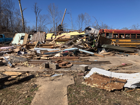
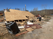
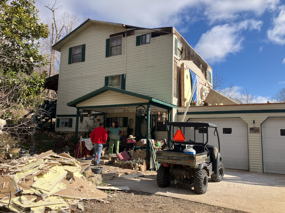
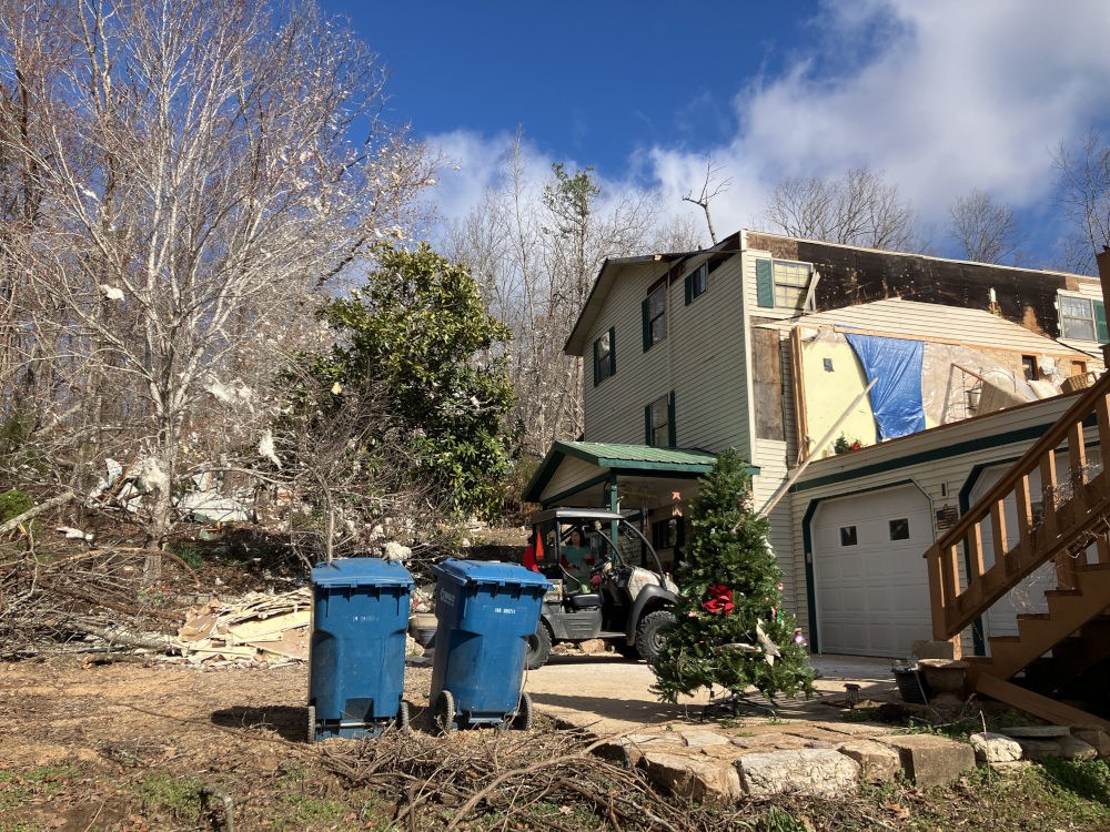
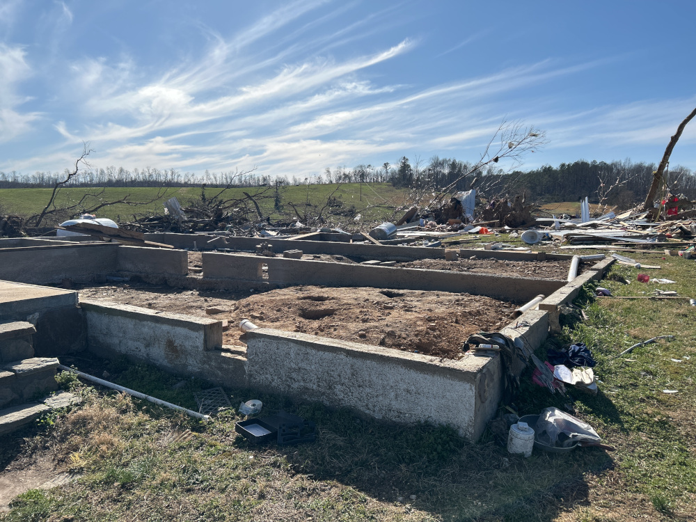
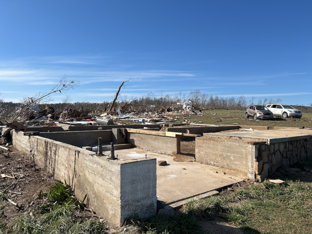
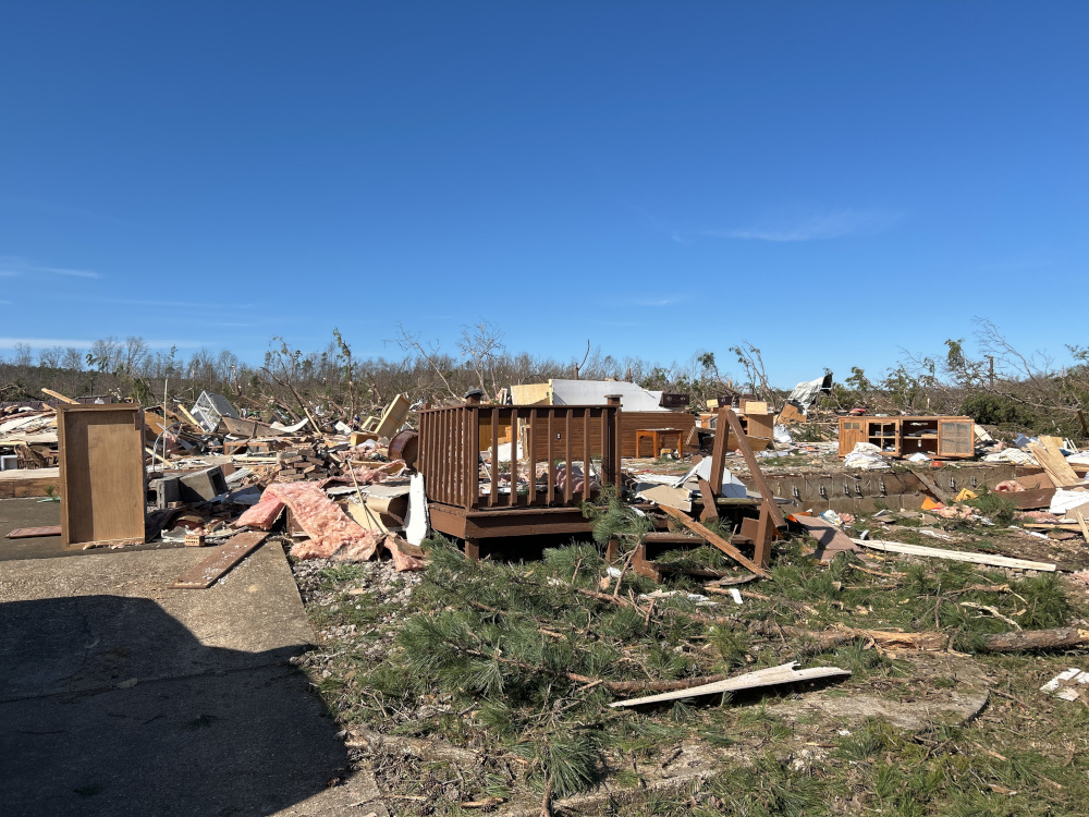
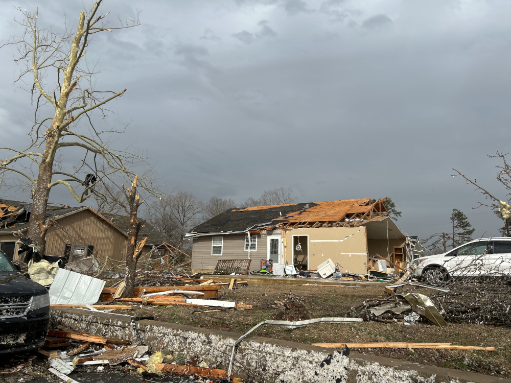
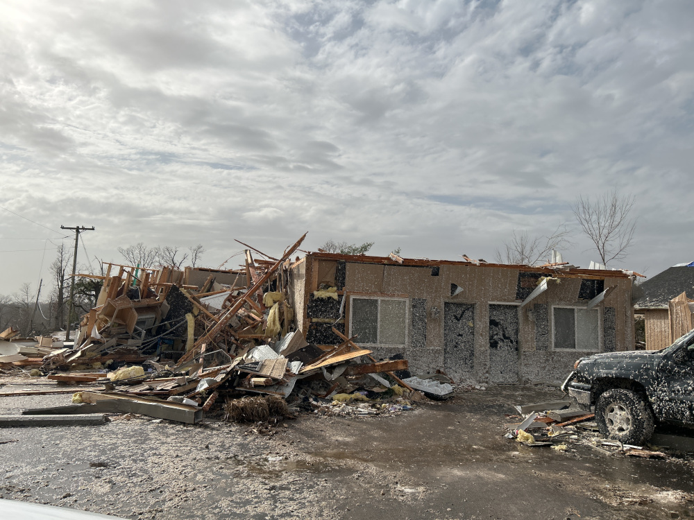
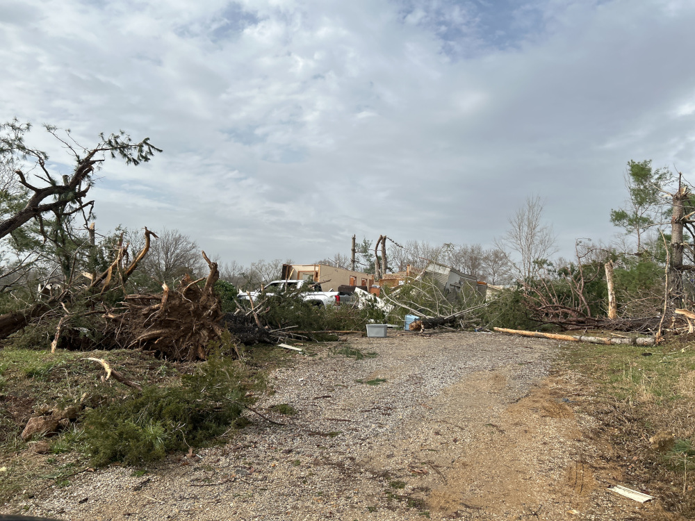
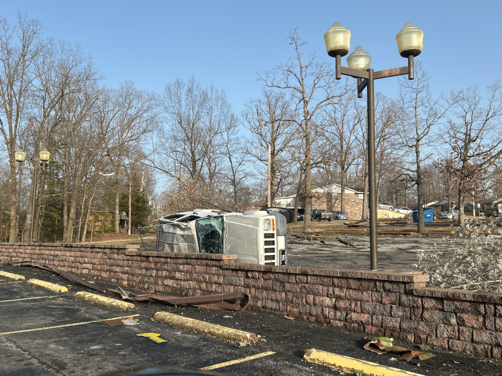
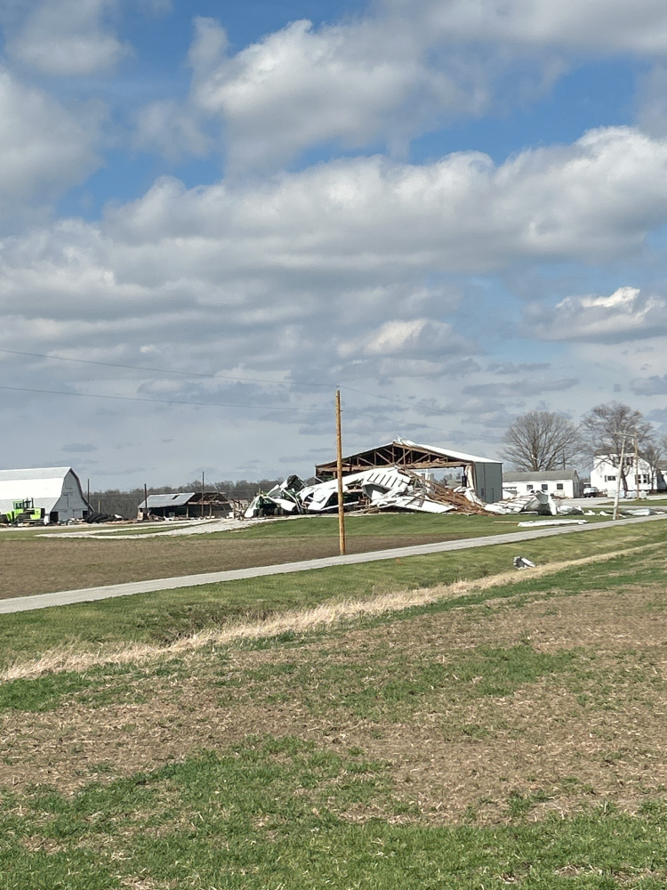
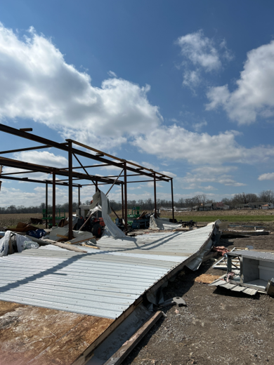
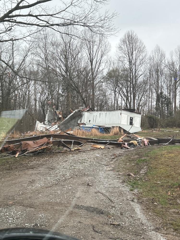
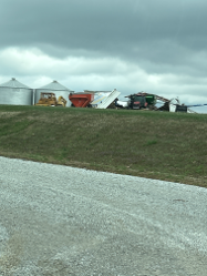
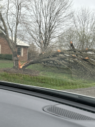
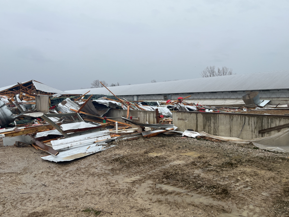
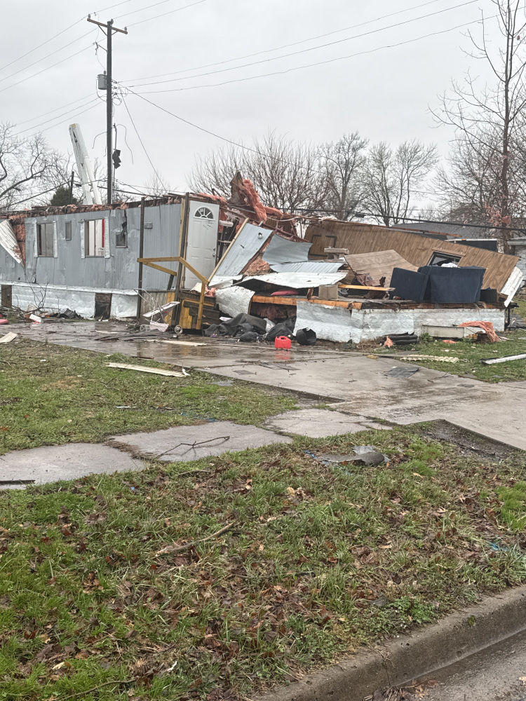
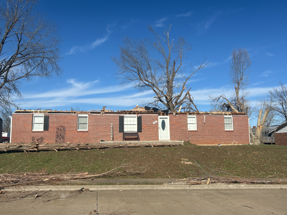
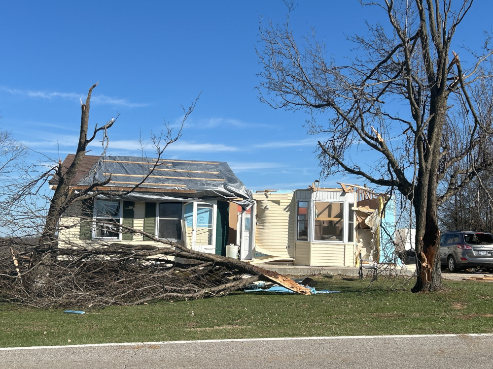
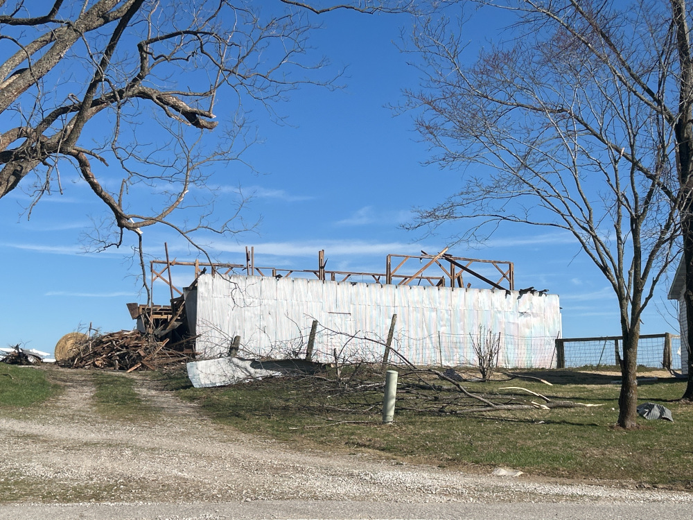
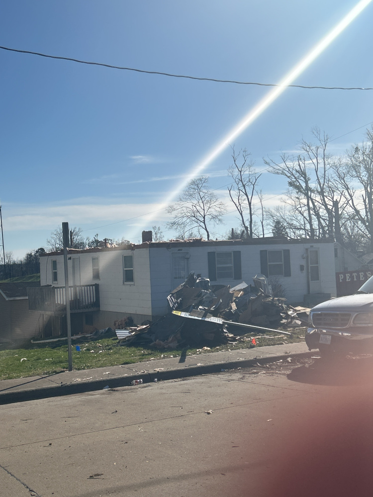
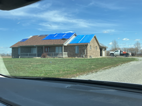
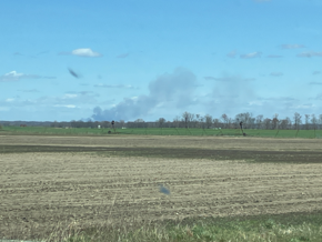
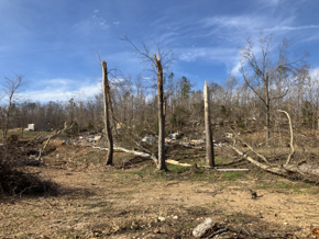
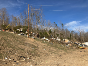
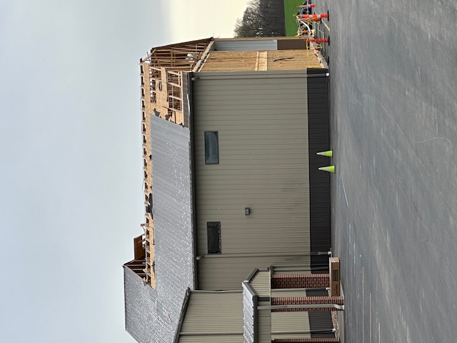
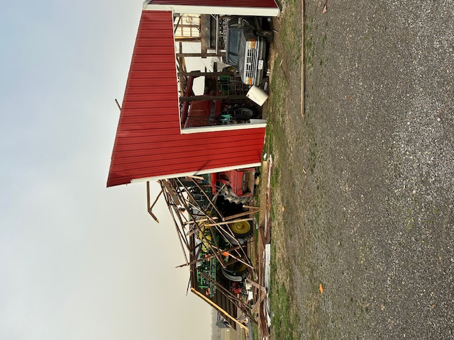
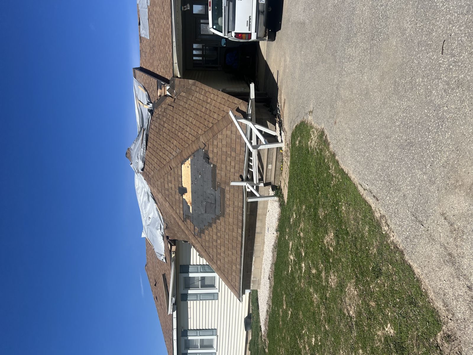
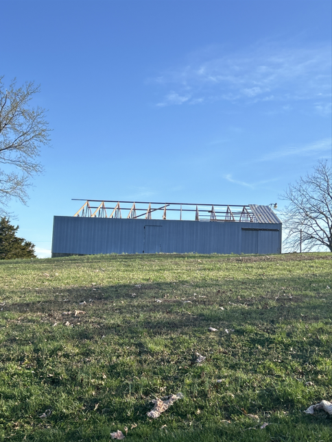
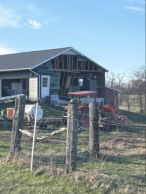
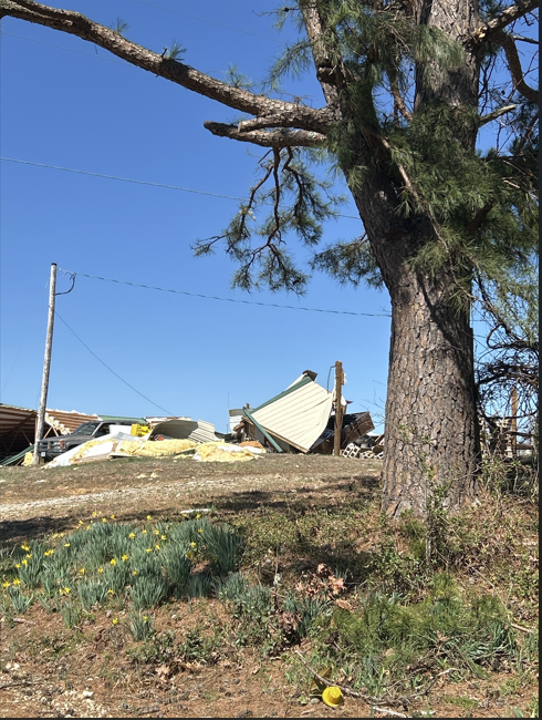
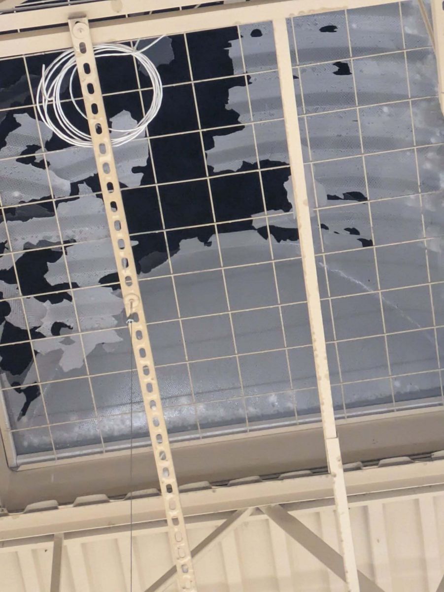
Storm Damage
 |
 |
 |
 |
| Damage in Poplar Bluff, MO (Photo by Crystal Stiles) |
Damage in Vienna, IL (WFCN/Swinford Media) |
Damage in Vienna, IL (WFCN/Swinford Media) |
Damage in Vienna, IL (WFCN/Swinford Media) |
 |
 |
 |
 |
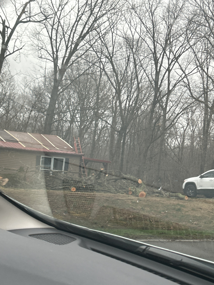
| Damage in Oakland City, IN (Photo by Peyton Davis |
Damage in Oakland City, IN (Photo by Peyton Davis |
Damage in Sesser, IL (WFCN/Swinford Media) |
Damage in Bollinger County, MO (NWS Survey) |
Radar:
 |
 |
 |
 |
| Storms impacting Carter Co., MO around 9:53 p.m. | Storms near Poplar Bluff, MO around 11:30 p.m. | Storms in northwest Wayne Co., MO around 10:38 p.m. | Storm with baseball hail in Owensboro, KY around 4:52 a.m. |
Storm Reports
Preliminary Local Storm Report...Summary
National Weather Service Paducah KY
1053 AM CDT Sat Mar 15 2025
..TIME... ...EVENT... ...CITY LOCATION... ...LAT.LON...
..DATE... ....MAG.... ..COUNTY LOCATION..ST.. ...SOURCE....
..REMARKS..
1155 AM Tstm Wnd Dmg 1 NE Cutler 38.04N 89.55W
03/14/2025 Perry IL Law Enforcement
Structural damage near Cutler, IL. Roof off
trailer on Lincoln Street and 2 barns
destroyed.
0248 PM Non-Tstm Wnd Gst 2 E Mount Vernon 38.32N 88.87W
03/14/2025 M40 MPH Jefferson IL AWOS
AWOS station KMVN Mt Vernon IL.
0250 PM Non-Tstm Wnd Gst 2 SE Heath 37.07N 88.77W
03/14/2025 M40 MPH McCracken KY ASOS
ASOS station KPAH Paducah KY.
0312 PM Non-Tstm Wnd Gst 3 SSW De Soto 37.78N 89.25W
03/14/2025 M47 MPH Jackson IL ASOS
ASOS station KMDH Carbondale IL.
0315 PM Non-Tstm Wnd Gst 3 NNE Lithium 37.87N 89.87W
03/14/2025 M45 MPH Perry MO AWOS
AWOS station KPCD Perryville MO.
0315 PM Non-Tstm Wnd Gst 3 NNE Lithium 37.87N 89.87W
03/14/2025 M45 MPH Perry MO AWOS
AWOS station KPCD Perryville MO.
0333 PM Non-Tstm Wnd Gst 5 W Ash Hill 36.77N 90.32W
03/14/2025 M52 MPH Butler MO ASOS
ASOS station KPOF Poplar Bluff MO.
0346 PM Non-Tstm Wnd Gst 3 WNW Scott City 37.23N 89.58W
03/14/2025 M44 MPH Scott MO ASOS
ASOS station KCGI Cape Girardeau MO.
0353 PM Non-Tstm Wnd Gst 3 NE Doniphan 36.65N 90.78W
03/14/2025 M40 MPH Ripley MO Mesonet
Mesonet station DFSM7 Doniphan MO.
0435 PM Non-Tstm Wnd Gst 2 E Sturgis 37.55N 87.95W
03/14/2025 M40 MPH Union KY AWOS
AWOS station KTWT 2 E Sturgis.
0448 PM Non-Tstm Wnd Dmg Marble Hill 37.30N 89.98W
03/14/2025 Bollinger MO Broadcast Media
Reports of power outages in Bollinger County
due to high gradient winds.
0541 PM Non-Tstm Wnd Dmg 2 WSW Neelyville 36.55N 90.55W
03/14/2025 Butler MO Emergency Mngr
Power poles downed on County Road 270 west
of Neelyville.
0547 PM Non-Tstm Wnd Gst 1 SE Energy 37.77N 89.02W
03/14/2025 M47 MPH Williamson IL AWOS
AWOS station KMWA Marion IL.
0552 PM Non-Tstm Wnd Gst 3 SSW De Soto 37.78N 89.25W
03/14/2025 M53 MPH Jackson IL ASOS
ASOS station KMDH Carbondale IL.
0650 PM Non-Tstm Wnd Gst 4 NE Marion 37.38N 88.04W
03/14/2025 M40 MPH Crittenden KY Mesonet
Mesonet station RPTN Marion KY 4 NE.
0706 PM Non-Tstm Wnd Dmg 1 SW Murphysboro 37.76N 89.35W
03/14/2025 Jackson IL Trained Spotter
Large branch about four inches in diameter
snapped from a tree.
0722 PM Non-Tstm Wnd Gst 1 SSE Chicopee 36.98N 91.00W
03/14/2025 M44 MPH Carter MO Mesonet
Mesonet station BGSM7 Chicopee MO.
1011 PM Tornado 6 N Van Buren 37.09N 91.00W
03/14/2025 Carter MO Emergency Mngr
Home reported destroyed on D Highway near
the Carter/Reynolds County line. Time
estimated.
1016 PM Tstm Wnd Dmg Freemont 36.95N 91.16W
03/14/2025 Carter MO Emergency Mngr
Windows blown out of a house near Fremont.
Possible tornado. Time estatimed.
1052 PM Non-Tstm Wnd Gst 3 SSW De Soto 37.78N 89.25W
03/14/2025 M58 MPH Jackson IL ASOS
ASOS station KMDH Carbondale IL.
1055 PM Non-Tstm Wnd Gst 3 NNE Lithium 37.87N 89.87W
03/14/2025 M56 MPH Perry MO AWOS
AWOS station KPCD Perryville MO.
1056 PM Hail 1 W Doniphan 36.62N 90.83W
03/14/2025 M1.00 Inch Ripley MO Public
Report from mPING: Quarter (1.00 in.).
1111 PM Funnel Cloud 4 W Oxly 36.59N 90.76W
03/14/2025 Ripley MO Law Enforcement
Location approximate.
1119 PM Non-Tstm Wnd Dmg Sesser 38.09N 89.05W
03/14/2025 Franklin IL Emergency Mngr
Tree fell through a home in Sesser.
1121 PM Non-Tstm Wnd Dmg 2 ENE Donaldson 36.76N 87.86W
03/14/2025 Trigg KY Broadcast Media
Tree down on Felix Wadlington Road.
1125 PM Hail 5 WSW Glenallen 37.29N 90.12W
03/14/2025 M1.50 Inch Bollinger MO Emergency Mngr
Near DD and BCR 810.
1133 PM Tstm Wnd Dmg Poplar Bluff 36.76N 90.41W
03/14/2025 Butler MO Emergency Mngr
Many reports of damage in Poplar Bluff.
Houses and buildings destroyed. Power
outages and gas leaks reported. Possible
tornado.
1135 PM Non-Tstm Wnd Gst 3 NNE Lithium 37.87N 89.87W
03/14/2025 M62 MPH Perry MO AWOS
AWOS station KPCD Perryville MO.
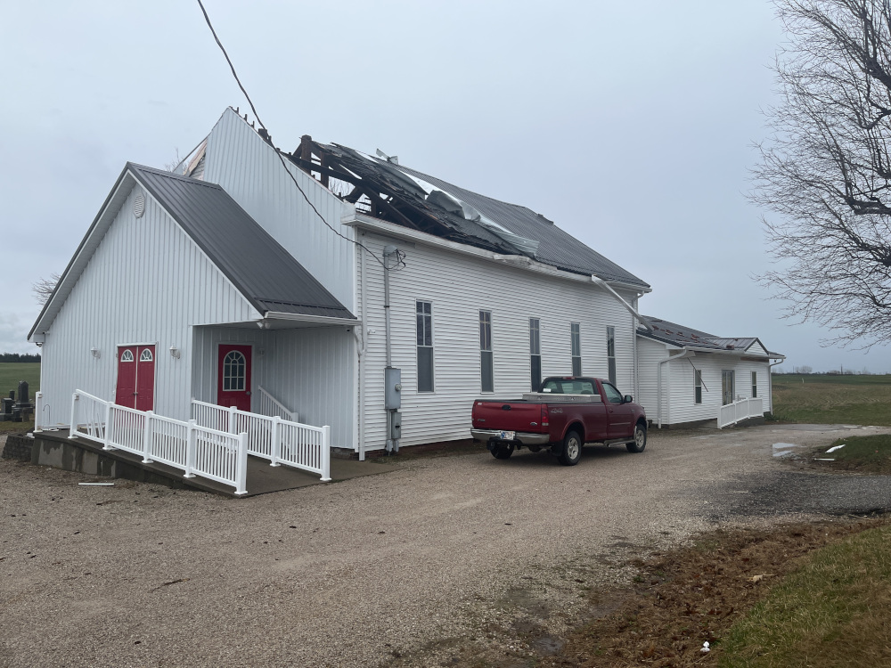
1135 PM Tornado 2 W Poplar Bluff 36.77N 90.45W
03/14/2025 Butler MO Emergency Mngr
Major damage reported to New Covenant
Fellowship Church and a neighboring trailer
park on PP Highway.
1138 PM Hail 2 W Perryville 37.73N 89.91W
03/14/2025 M1.25 Inch Perry MO Public
Report from mPING of Half Dollar (1.25 in.)
hail.
1140 PM Tornado 1 S Perryville 37.71N 89.87W
03/14/2025 Perry MO Law Enforcement
Multiple structures with major damage on the
south side of Perryville.
1140 PM Tstm Wnd Dmg 1 ESE Perryville 37.72N 89.86W
03/14/2025 Perry MO Law Enforcement
Damage reported on the south side of
Perryville. Possible tornado.
1144 PM Non-Tstm Wnd Gst 3 WNW Scott City 37.23N 89.58W
03/14/2025 M61 MPH Scott MO ASOS
ASOS station KCGI Cape Girardeau MO.
1152 PM Non-Tstm Wnd Gst 3 SSW De Soto 37.78N 89.25W
03/14/2025 M55 MPH Jackson IL ASOS
ASOS station KMDH Carbondale IL.
1200 AM Tornado 3 NE Puxico 36.98N 90.11W
03/15/2025 Stoddard MO Emergency Mngr
Reported near PP Highway and CR 254.
1203 AM Tstm Wnd Dmg 2 W Ava 37.88N 89.53W
03/15/2025 Jackson IL Trained Spotter
Six inch tree over Little Kinkaid Rd, east
of McClure Rd .
1212 AM Tstm Wnd Dmg 8 W Pinckneyville 38.08N 89.53W
03/15/2025 Perry IL Emergency Mngr
Power poles reported down on Highway 154.
Time estimated from radar.
1217 AM Tstm Wnd Dmg Du Quoin 38.00N 89.24W
03/15/2025 Perry IL Law Enforcement
Multiple reports of trees and power poles
down in Du Quoin.
1228 AM Tstm Wnd Gst 3 WNW Scott City 37.23N 89.58W
03/15/2025 M77 MPH Scott MO ASOS
ASOS station KCGI Cape Girardeau MO.
1236 AM Tornado 2 E New Hamburg 37.13N 89.56W
03/15/2025 Scott MO Trained Spotter
Trained spotter reported a tornado just
north of Benton with power poles down.
1240 AM Tornado 2 N Colp 37.83N 89.08W
03/15/2025 Williamson IL Fire Dept/Rescue
Tornado reported north of Carterville.
0106 AM Tstm Wnd Dmg Sikeston 36.88N 89.58W
03/15/2025 Scott MO Emergency Mngr
Damage reported at a nursing home in
Sikeston near George E Day parkway area.
Possible tornado.
0130 AM Hail Ledbetter 37.05N 88.50W
03/15/2025 M1.75 Inch Livingston KY Public
Public photo of hail 1.75 inches near
Ledbetter.
0131 AM Tornado 4 SSE New Burnside 37.53N 88.75W
03/15/2025 Johnson IL Trained Spotter
Severe damage to a home on Gilead Church
Road. No injuries.
0140 AM Hail 1 E Howardville 36.57N 89.58W
03/15/2025 E1.25 Inch New Madrid MO Public
Report from mPING of Half Dollar (1.25 in.)
hail.
0141 AM Hail 1 E Howardville 36.57N 89.58W
03/15/2025 E1.50 Inch New Madrid MO Public
Report from mPING: Ping Pong Ball (1.50
in.).
0146 AM Hail 1 SE Harrisburg 37.73N 88.53W
03/15/2025 E1.25 Inch Saline IL Public
Report from mPING of Half Dollar (1.25 in.)
hail.
0149 AM Hail Harrisburg 37.74N 88.55W
03/15/2025 M1.75 Inch Saline IL Public
0215 AM Hail Columbus 36.76N 89.10W
03/15/2025 M1.00 Inch Hickman KY Fire Dept/Rescue
0228 AM Tstm Wnd Dmg Paducah 37.07N 88.64W
03/15/2025 McCracken KY Emergency Mngr
Tree down blocking the road on North
Friendship and Guyline road.
0231 AM Tstm Wnd Dmg 1 W Shady Grove 37.12N 88.59W
03/15/2025 Massac IL Emergency Mngr
Tree down on house in Brookport. Line
damage.
0241 AM Hail 1 S Poseyville 38.16N 87.78W
03/15/2025 E1.00 Inch Posey IN Public
Report from mPING of Quarter (1.00 in.)
hail.
0245 AM Tstm Wnd Dmg 4 NNW Darmstadt 38.14N 87.61W
03/15/2025 Vanderburgh IN Trained Spotter
Roof blown off building along Owensville
Road.
0245 AM Tstm Wnd Dmg 4 NNW Darmstadt 38.14N 87.61W
03/15/2025 Vanderburgh IN Trained Spotter
Roof blown off of a building along
Owensville Road.
0256 AM Hail Princeton 38.36N 87.57W
03/15/2025 M1.75 Inch Gibson IN Trained Spotter
0300 AM Tstm Wnd Dmg 4 E Sturgis 37.56N 87.91W
03/15/2025 Union KY Emergency Mngr
Double wide knocked off its foundation,
front porch ripped off, roof ripped off.
0305 AM Tornado Oakland City 38.34N 87.35W
03/15/2025 Gibson IN Broadcast Media
Security camera footage showed a tornado in
Oakland City. Damage reported around the
city.
0305 AM Tornado Oakland City 38.34N 87.35W
03/15/2025 Gibson IN Broadcast Media
Tornado captured on security camera footage
in Oakland City.
0305 AM Tornado Oakland City 38.34N 87.35W
03/15/2025 Gibson IN Broadcast Media
Screen shot of security camera footage of a
tornado in Oakland City.
0307 AM Tstm Wnd Gst 2 ESE Sturgis 37.54N 87.95W
03/15/2025 M60 MPH Union KY AWOS
0319 AM Hail Lone Oak 37.04N 88.67W
03/15/2025 M1.00 Inch McCracken KY Public
0320 AM Tstm Wnd Gst 5 E Henderson 37.84N 87.49W
03/15/2025 M72 MPH Henderson KY Mesonet
72 mph wind gust measurement by Mesonet site
at 3:20 am.
0320 AM Tstm Wnd Gst Newburgh 37.95N 87.40W
03/15/2025 M67 MPH Warrick IN Mesonet
0330 AM Tstm Wnd Dmg Robards 37.67N 87.55W
03/15/2025 Henderson KY Emergency Mngr
Sporadic reports of power lines down in the
Robards area.
0340 AM Hail Clay 37.48N 87.82W
03/15/2025 M1.00 Inch Webster KY Trained Spotter
Thirty to fourty-five seconds of quarter
size hail in Clay.
0357 AM Hail 3 NE Sebree 37.62N 87.48W
03/15/2025 E1.75 Inch McLean KY Public
Report from mPING of Golf Ball (1.75 in.)
hail.
0430 AM Hail 4 WNW Rockport 37.90N 87.12W
03/15/2025 M1.00 Inch Spencer IN Trained Spotter
Hail just over quarter sized.
0443 AM Hail 5 S Stanley 37.76N 87.23W
03/15/2025 M1.50 Inch Daviess KY Trained Spotter
0450 AM Hail 3 N Moseleyville 37.71N 87.18W
03/15/2025 M1.75 Inch Daviess KY Trained Spotter
Golf ball sized hail 1 mile east of Panther
Creek Park.
0456 AM Hail 2 W Owensboro 37.75N 87.15W
03/15/2025 M2.00 Inch Daviess KY Public
Damage to vehicles and windshields from
large hail.
0456 AM Hail 2 E Owensboro 37.75N 87.08W
03/15/2025 E1.75 Inch Daviess KY Public
Report from mPING of Golf Ball (1.75 in.)
hail.
0458 AM Hail 4 WNW Calhoun 37.57N 87.32W
03/15/2025 M1.50 Inch McLean KY Fire Dept/Rescue
Measured in Poverty, Kentucky.
0458 AM Hail 2 SW Owensboro 37.73N 87.14W
03/15/2025 E2.00 Inch Daviess KY Public
Report from mPING of Hen Egg (2.00 in.)
hail.
0458 AM Hail 4 E Owensboro 37.76N 87.05W
03/15/2025 M2.50 Inch Daviess KY Public
Report from mPING of Tennis Ball (2.50 in.)
hail.
0501 AM Hail 2 E Owensboro 37.76N 87.08W
03/15/2025 M2.75 Inch Daviess KY NWS Employee
Picture shared on social media of baseball
sized hail.
0513 AM Hail 5 NW Pellville 37.78N 86.89W
03/15/2025 E1.50 Inch Daviess KY Public
Report from mPING of Ping Pong Ball (1.50
in.) hail.
0539 AM Hail Masonville 37.68N 87.03W
03/15/2025 M1.25 Inch Daviess KY Trained Spotter
&&
Environment
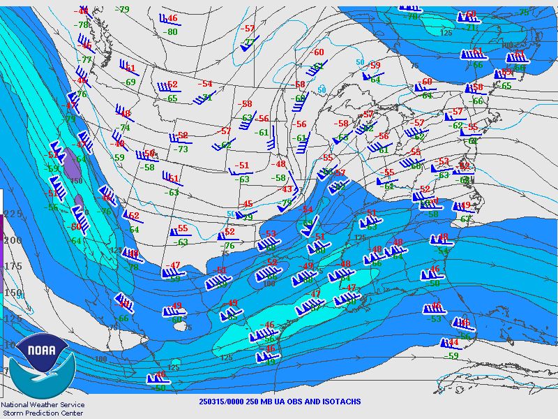
A sharp negatively-tilted leading shortwave trough broke out ahead of a lumbering and broad trough over much of the western U.S. This rapidly strengthened a low-level cyclone over the central US that dramatically increased the low-level wind fields over the Mid-Mississippi Valley on March 14th. These strong southerly winds advected rich Gulf moisture and heat into the area. Lift from the sharp shortwave trough steepened mid-level lapse rates considerably and the strong southwesterlies at 500-700mb advected a strong elevated mixed layer over the area that further contributed to steepening mid-level lapse rates and placed a small 'cap' on instability preventing storm development until the best large-scale conditions were in place.
Low-level wind fields were extreme, with velocities at 3000-4000 ft above ground recorded at over 65 kts (80 mph). These strong winds led to extreme shear with low-level shear values about 7 times that necessary for tornado potential. The combination of shear, and instability maximized over southeast Missouri where Significant Tornado Parameter values reached 10-12 according to operational estimates between 9 pm and midnight. This is an exceptionally supportive environment that the region would likely only experience once every few years on average. As the low began to move northeast the shear values relaxed somewhat and the extreme tornado production of the cells waned a bit. The strong deep-layer shear and steep lapse rates were still sufficient however to create a destructive hail storm over the Owensboro community in the pre-dawn hours Saturday.
The synoptic scale pattern was well modeled allowing for outlook and forecast information to be issued days in advance of the event. The mesoscale pattern was also modeled reasonably well, and the explosive parameter space was made evident prior to the event.
 |
 |
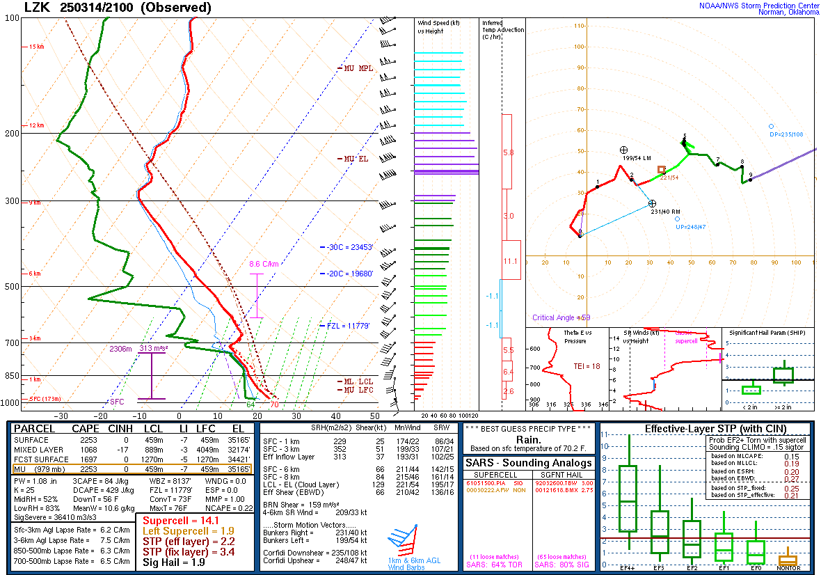 |
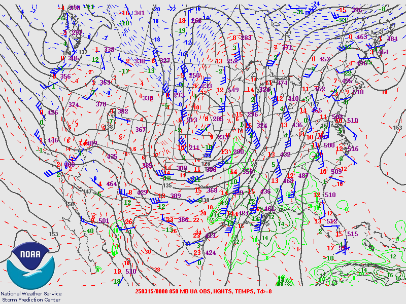
| 250 mb analysis just before the vent began with a broad and strong trough over most of the western US and a sharp negatively-tilted shortwave over the Missouri Valley. | 850mb analysis a few hours before the event with a very large area of 50-60 kt winds. These winds are exceptionally strong and fed the low-level wind shear that aided in tornado production. | Sounding from Little Rock, AR a few hours before the event showing a classic "loaded gun" observation with relatively strong instability held back by a weak capping inversion at the base of an elevated mixed-layer with steep mid level lapse rates. |
Near-storm environment summary.
 |
 |
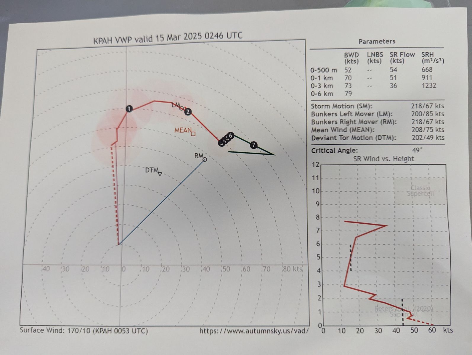 |
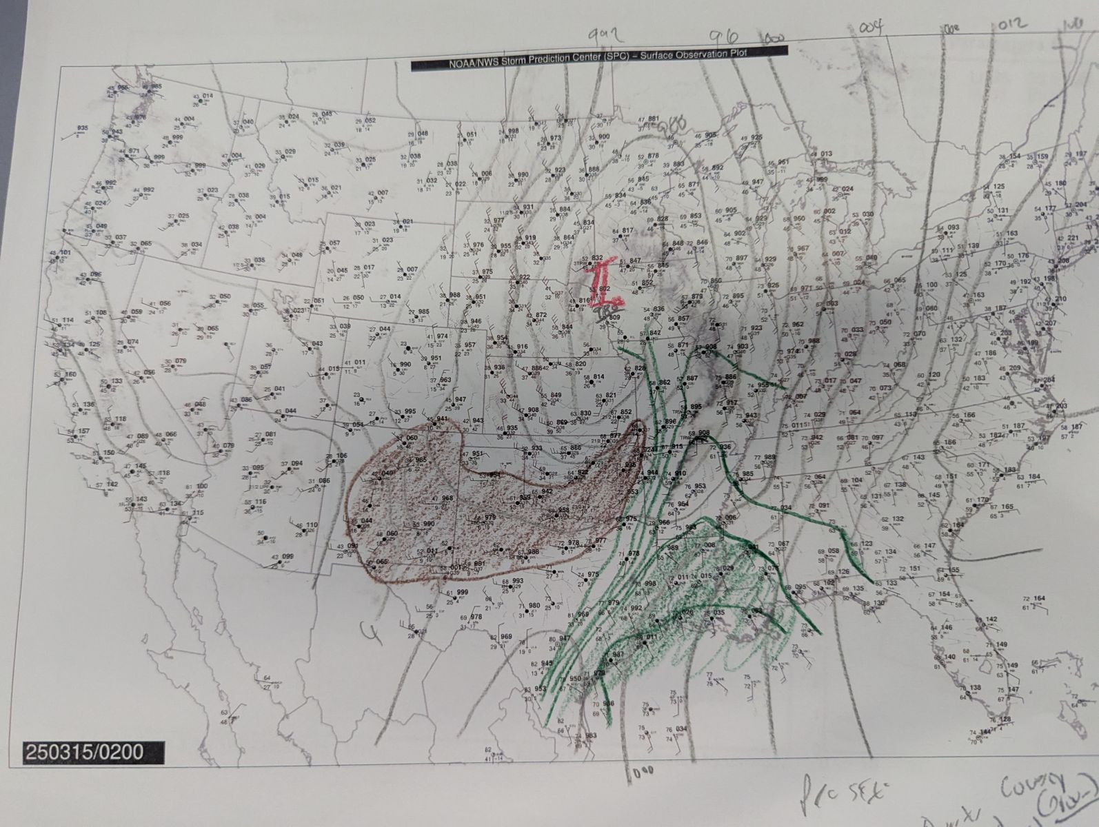
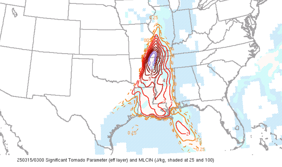
| Operational hand-analysis from the event showing a ribbon of rich low-level moisture streaming into the region ahead of a very strong surface cyclone that was pulling in significantly drier air from the west. This led to very strong wind fields and heat and moisture for storms to work with. | Operational Significant Tornado Parameter product at the peak of the event. The vaue is spiking at 10, which is exceptional. Values above 1 are often associated with strong tornadoes, where violent tornadoes tend to occur in values greater than 7. | Hodograph from the Paducah NEXRAD during the event. The hodograph shows tremendous curvature and a classic sickle shape. The 0-1 km Storm Relative Helicity Value reads 911 m2/s2. Values above 150 m2/s2 are often associated with tornadic activity. |
Additional environmental data.
 |
 |
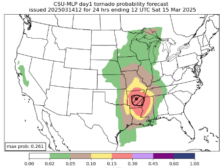 |
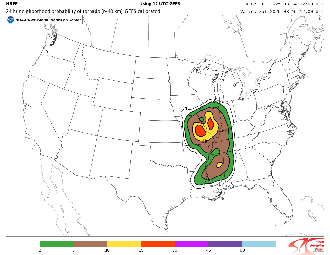
| HREF mean significant tornado parameter forecast the morning of the event. Forecast values were extremely high and close to what was observed operationally. | HREF tornado probability guidance from the morning of the event. Values indicated high tornado potential over much of the area that was eventually impacted. | Colorado State Univ. severe weather machine learning output from the morning before the event. A significant tornado threat is highlighted in the vicinity of the eventual event and over an area that was significantly impacted. |
Additional Information
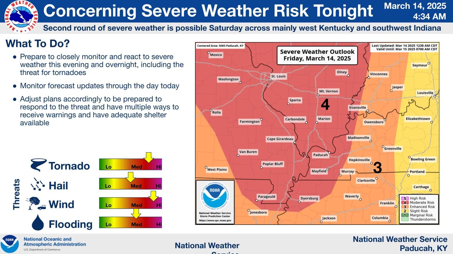
The Forecast
 |
 |
 |
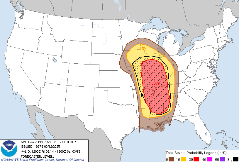 |
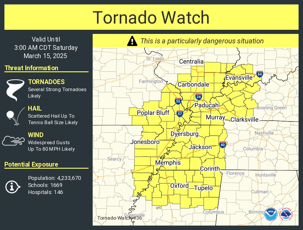
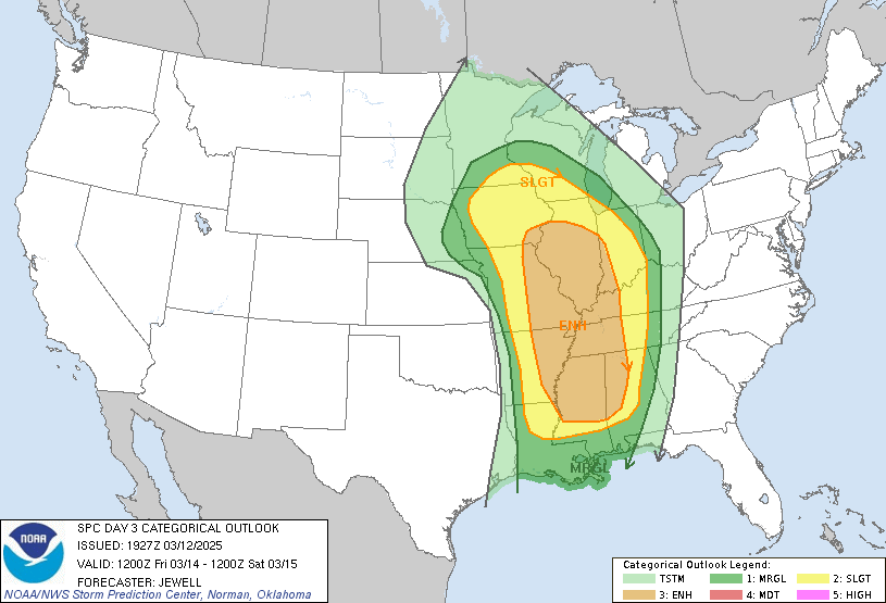
| Weather Story Graphic | Tornado Watch | SPC Day 3 Categorical Outlook | SPC Day 3 Probabilistic Outlook |
 |
 |
 |
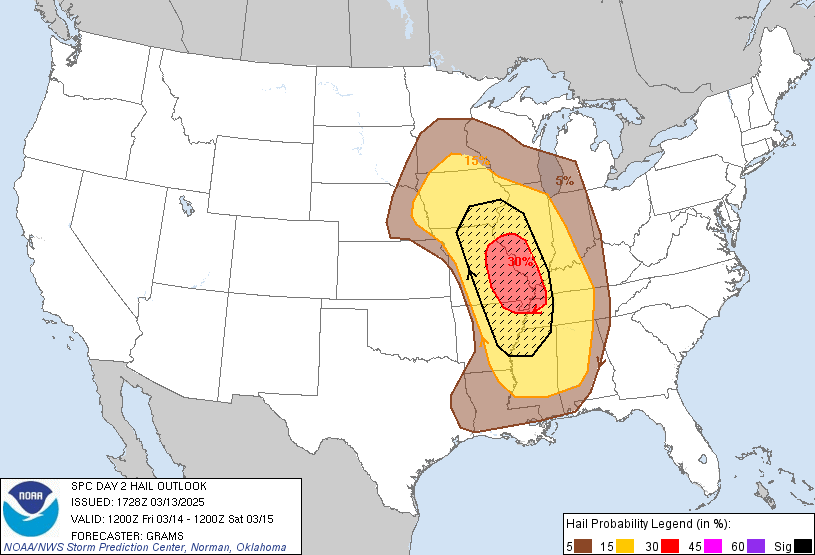 |
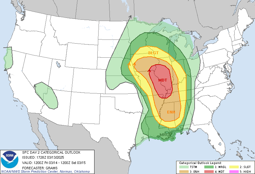
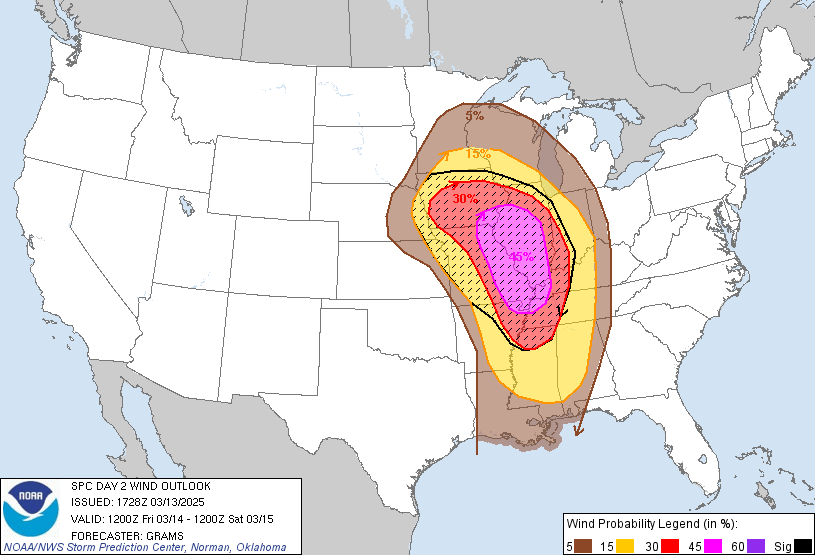
| SPC Day 2 Categorical Outlook | SPC Day 2 Probabilistic Tornado Outlook | SPC Day 2 Probabilistic Wind Outlook | SPC Day 2 Probabilistic Hail Outlook |
 |
 |
 |
 |
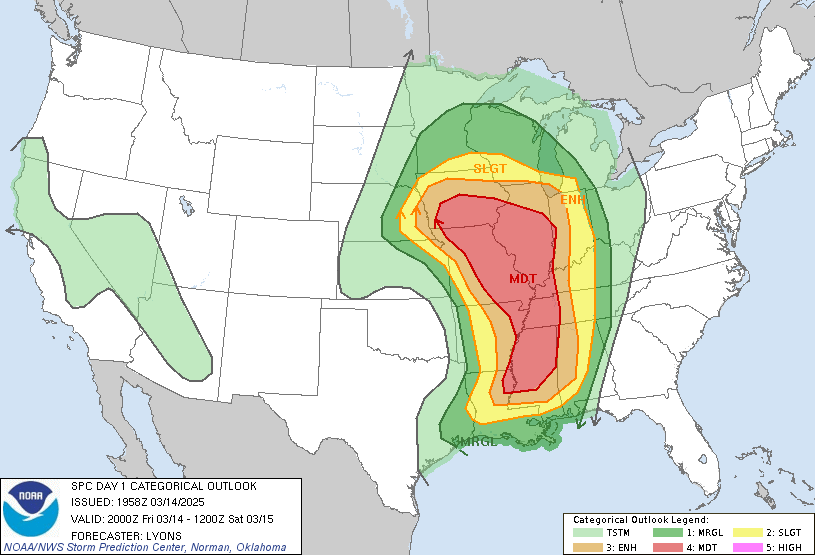
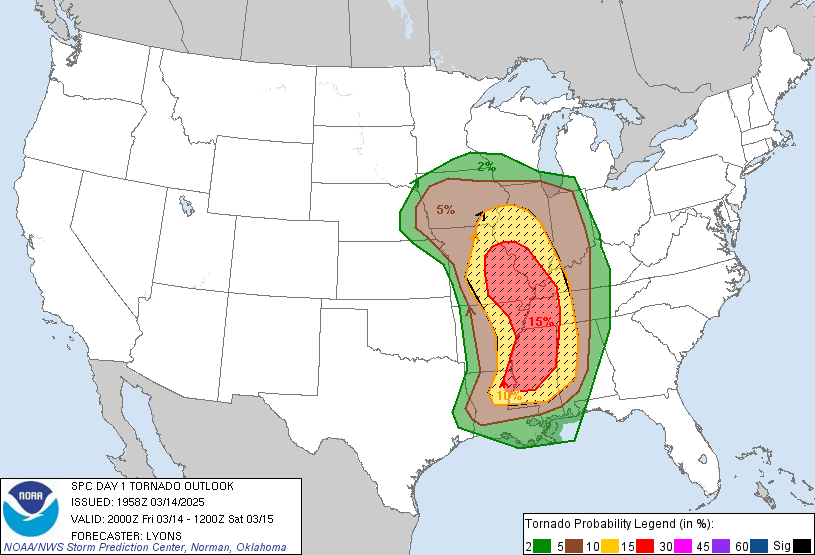
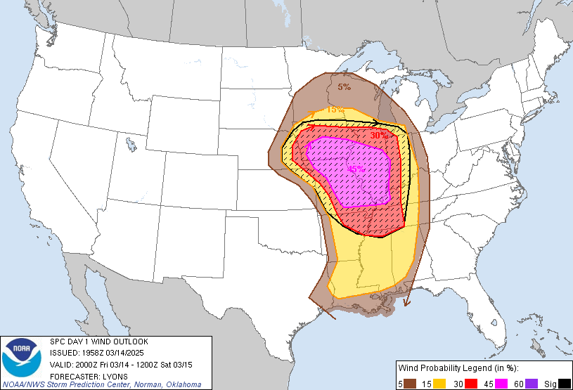
| SPC Day 1 Categorical Outlook | SPC Day 1 Probabilistic Tornado Outlook | SPC Day 1 Probabilistic Hail Outlook | SPC Day 1 Probabilistic Wind Outlook |
Summaries from other NWS Offices
 |
Media use of NWS Web News Stories is encouraged! Please acknowledge the NWS as the source of any news information accessed from this site. |
|