
Excessive rainfall may produce locally considerable flash flooding over parts of the northwestern Gulf Coast, lower Mississippi River Valley, and Deep South through Thursday. Potential Tropical Cyclone One is forecast to become a tropical storm (Arthur) as it moves along or just off the northwestern Gulf coast through Wednesday. An outbreak of severe weather is forecast in the Midwest Wednesday. Read More >
Overview
A very unstable airmass was in place ahead of a weak mid-level disturbance that moved into the area. Temperatures surged into the upper 80s to lower 90s within a very moist airmass characterized by tropical-like dewpoints in the mid to upper 70s. Scattered thunderstorms rapidly developed around 11am near a remnant outflow boundary from earlier convection. The storms formed into several clusters that moved southeast across portions of southeast IL, southwest IN, and much of western KY. The main threat was damaging winds, with a few scattered small hail reports as well.Warnings:
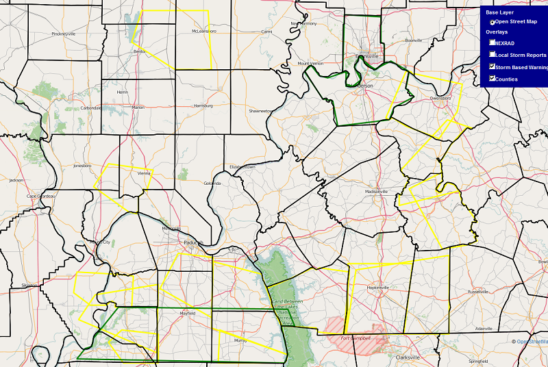
The graphic below shows an overview of all of the severe thunderstorm (yellow) and flood warnings (green) issued during the event, overlayed on top of each other. Overall 14 severe thunderstorm warnings were issued with all but 2 of them being in portions of western KY. The timeframe for all of the warnings was roughly from 12:00pm to 3:45pm.
(Click on the image to enlarge it)
Photos:
 |
 |
 |
 |
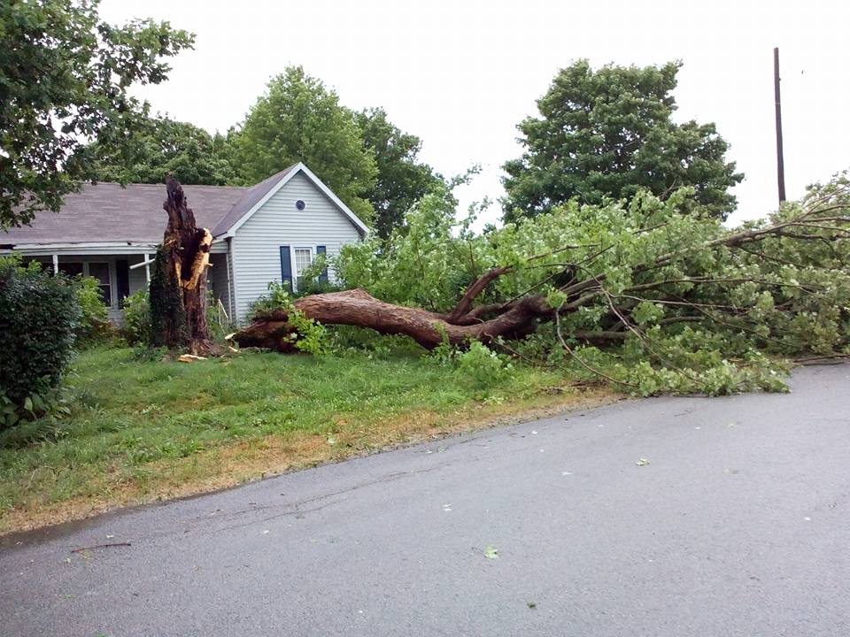
| Wind damage in Hickman County - Courtesy of Beau Dodson | Tree damage in Hickman County - Courtesy of Beau Dodson | Tree Damage in Gracey, KY - Courtesy of Kevin Hurt | Tree Damage in Gracey, KY - Courtesy of Ginger McManis |
 |
 |
 |
 |
| Shelf cloud rolling into Princeton, IN - Courtesy of Lori McClellan | Shelf cloud approaches Evansville, IN - Courtesy of Mike Fetscher | Mammatus Clouds over Paducah, KY - Courtesy of NWS employee Sean Poulos | Rainbow near Petersburg, IN - Courtesy of Cary Bailey |
Radar:
Click here for a radar loop of this event
The above link shows an animated radar loop in 15 minute increments, from 10am until 7pm:
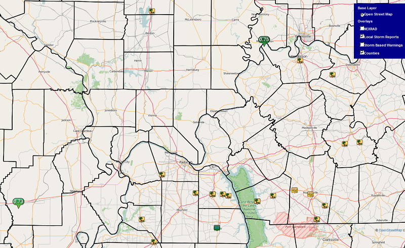
Storm Reports
Here is a graphic of all the storm reports received throughout the event. Nearly all of the reports were wind related, with the only hail reports being sub-severe (under 1 inch diameter).
(Click on the image to enlarge it)
PRELIMINARY LOCAL STORM REPORT...SUMMARY
NATIONAL WEATHER SERVICE PADUCAH KY
957 PM CDT WED JUN 15 2016

..TIME...   ...EVENT...      ...CITY LOCATION...     ...LAT.LON...
..DATE...   ....MAG....      ..COUNTY LOCATION..ST.. ...SOURCE....
            ..REMARKS..

1229 PM     HEAVY RAIN       MOUNT VERNON            37.94N 87.90W
06/15/2016  E0.75 INCH       POSEY              IN   TRAINED SPOTTER

            AROUND THREE QUARTER INCH ACCUMULATION WITHIN 20 MINUTES.


1235 PM     TSTM WND DMG     INA                     38.15N 88.90W
06/15/2016                   JEFFERSON          IL   LAW ENFORCEMENT

            LATE REPORT- POWER LINES AND TREES DOWN NEAR INA AND
            SOUTHERN PORTIONS OF THE COUNTY

0118 PM     HEAVY RAIN       DUDLEY                  36.79N 90.09W
06/15/2016  M0.73 INCH       STODDARD           MO   TRAINED SPOTTER

            NEARLY THREE QUARTER INCH OF RAIN WITHIN 20 MINUTES.

0123 PM     TSTM WND DMG     2 NE LOVELACEVILLE      36.99N 88.81W
06/15/2016                   MCCRACKEN          KY   NWS EMPLOYEE

            TREES SNAPPED AND UPROOTED ALONG HWY 62 IN 3 LOCATIONS.
            FIRE RESCUE AND LAW ENFORCEMENT ARE RESPONDING.

0135 PM     TSTM WND DMG     3 S SYMSONIA            36.86N 88.51W
06/15/2016                   GRAVES             KY   LAW ENFORCEMENT

            *** 1 FATAL *** DELAYED REPORT. DEPUTY SHERIFF REPORTED
            THAT A TREE FELL ONTO THE CAB OF A TRUCK...KILLING THE
            DRIVER.

0145 PM     TSTM WND DMG     10 WSW OWENSBORO        37.70N 87.29W
06/15/2016                   DAVIESS            KY   LAW ENFORCEMENT

            SEVERAL TREES DOWN ON WEST SIDE OF COUNTY. ALSO A LARGE
            TREE LIMB DOWN ON EAST SIDE OF OWENSBORO.

0150 PM     TSTM WND DMG     3 S HENDERSON           37.80N 87.58W
06/15/2016                   HENDERSON          KY   BROADCAST MEDIA

            LATE REPORT. TREES DOWN ALONG HWY 136.

0155 PM     TSTM WND GST     MURRAY                  36.61N 88.32W
06/15/2016  M55.00 MPH       CALLOWAY           KY   AWOS

0159 PM     TSTM WND DMG     BENTON                  36.85N 88.36W
06/15/2016                   MARSHALL           KY   EMERGENCY MNGR

            EM REPORTS NUMEROUS TREES DOWN ALONG ROADWAYS. HEAVY RAIN
            AND STRONG WINDS REPORTED WITH STORMS.

0200 PM     TSTM WND DMG     BENTON                  36.85N 88.36W
06/15/2016                   MARSHALL           KY   EMERGENCY MNGR

            LATE REPORT. TREES DOWN ALONG HWY 641 JUST SOUTH OF
            BENTON AND ALONG OAK LEVEL ROAD NEAR THE MARSHALL/GRAVES
            COUNTY LINE. STRUCTURAL DAMAGE TO BARNS AND TREES DOWN AT
            4266 WADESBORO RD N 6 MILES WEST OF BENTON

0200 PM     TSTM WND DMG     FAIRDEALING             36.84N 88.22W
06/15/2016                   MARSHALL           KY   TRAINED SPOTTER

            3 FOOT DIAMETER TREE SNAPPED.

0205 PM     TSTM WND DMG     MURRAY                  36.61N 88.32W
06/15/2016                   CALLOWAY           KY   PUBLIC

            TREE DOWN AT INTERSECTION OF 4TH AND OLIVE.

0210 PM     TSTM WND GST     MURRAY                  36.61N 88.32W
06/15/2016  E65.00 MPH       CALLOWAY           KY   TRAINED SPOTTER

            WIND ESTIMATED. PEA SIZE HAIL REPORTED WITH THIS STORM.

0215 PM     TSTM WND DMG     CLINTON                 36.67N 88.99W
06/15/2016                   HICKMAN            KY   EMERGENCY MNGR

            LATE REPORT. NUMEROUS TREES DOWN. CORN LAID OVER. ONE
            TREE FELL ACROSS A HOME BUT NO INJURIES REPORTED. MOST
            DAMAGE REPORTED ALONG SARTEN ROAD AND HWY 51 SOUTH.

0215 PM     TSTM WND DMG     5 E BENTON              36.85N 88.27W
06/15/2016                   MARSHALL           KY   FIRE DEPT/RESCUE

            TREES DOWN AND SNAPPED ALONG THE FORT LEASURE TRAIL.

0219 PM     TSTM WND GST     CANTON                  36.80N 87.96W
06/15/2016  M47.00 MPH       TRIGG              KY   DEPT OF HIGHWAYS

            REPORTED ALONG THE HWY 80 BRIDGE AT MILE MARKER 63
            CROSSING LAKE BARKLEY.

0225 PM     FLASH FLOOD      MURRAY                  36.61N 88.32W
06/15/2016                   CALLOWAY           KY   TRAINED SPOTTER

            WATER ON ROADWAY. TREE BRANCHES DOWN WITH POWER OUTAGES
            REPORTED IN THE HARDIN AREA.

0235 PM     TSTM WND DMG     CANTON                  36.80N 87.96W
06/15/2016                   TRIGG              KY   EMERGENCY MNGR

            TREE DOWN ALONG LINTON ROAD. LOST ALL OF THE TRAFFIC
            BARRELS ON THE NEW BARKLEY BRIDGE PROJECT.

0245 PM     TSTM WND DMG     DRAKESBORO              37.22N 87.05W
06/15/2016                   MUHLENBERG         KY   LAW ENFORCEMENT

            LATE REPORT - TREE DOWN IN DRAKESBORO

0245 PM     TSTM WND DMG     FULTON                  36.51N 88.88W
06/15/2016                   FULTON             KY   LAW ENFORCEMENT

            SEVERAL TREES DOWN AROUND THE FULTON AREA ALONG HWY 307
            AND ALSO NEAR THE PURCHASE PARKWAY.

0245 PM     TSTM WND DMG     2 S CADIZ               36.84N 87.82W
06/15/2016                   TRIGG              KY   EMERGENCY MNGR

            TREE DOWN ALONG SOUTH ROAD.

0250 PM     TSTM WND DMG     GREENVILLE              37.21N 87.18W
06/15/2016                   MUHLENBERG         KY   LAW ENFORCEMENT

            LATE REPORT - POWER LINES DOWN NEAR GREENVILLE

0255 PM     TSTM WND GST     GRACEY                  36.88N 87.63W
06/15/2016  E65.00 MPH       CHRISTIAN          KY   PUBLIC

            WINDS ESTIMATED

0257 PM     TSTM WND GST     HOPKINSVILLE            36.85N 87.49W
06/15/2016  M57.00 MPH       CHRISTIAN          KY   EMERGENCY MNGR

            MEASURED ALONG THE WEST BYPASS.

0305 PM     TSTM WND GST     OAK GROVE               36.67N 87.43W
06/15/2016  E55.00 MPH       CHRISTIAN          KY   TRAINED SPOTTER

            WIND GUSTS ESTIMATED 50 TO 55 MPH. POWER OUTAGES
            REPORTED.

0315 PM     TSTM WND DMG     PEMBROKE                36.77N 87.36W
06/15/2016                   CHRISTIAN          KY   TRAINED SPOTTER

            TREES DOWN IN PEMBROKE AND HOPKINSVILLE. POWER OUTAGES
            REPORTED IN BOTH COMMUNITIES.

0320 PM     TSTM WND DMG     OAK GROVE               36.67N 87.43W
06/15/2016                   CHRISTIAN          KY   BROADCAST MEDIA

            POWER OUTAGES REPORTED THROUGHOUT THE COMMUNITY
 |
Media use of NWS Web News Stories is encouraged! Please acknowledge the NWS as the source of any news information accessed from this site. |
|

