Overview
Two rounds of thunderstorms produced severe weather across the area on July 8th. The first round came through during the morning hours with winds of at least 70 mph in the Owensboro, KY area. Then in the afternoon and evening hours, a complex of thunderstorms produced damaging winds and flash flooding as they moved across southeast MO, western KY, and far southern IL. These storms produced wind damage all the way from Van Buren, MO to Elkton, KY! This was the third straight day of widespread thunderstorms, so heavy rainfall quickly resulted in flooding in those areas already hit hard by recent heavy rain.
Photos:
Header
 |
 |
 |
 |
| Large part of tree blown onto residence property in Wingo, KY - (via Casey Archey) | Tree down on Husbands Rd in Paducah - (via Gary Goin) | Lightning strike near Murray, KY (via Chris Smothers) |
Storm moving into Cape Girardeau - (via Aaron Palmer) |
 |
 |
 |
| Water over Maxon Rd in West Paducah, KY (via Vicki Crumpton) | Street flooding in Sikeston, MO (via Debbie Baker) |
Rainbow after the storms in Ledbetter, KY (via Cindy Henson Yates) |
Radar:
Click here for a radar loop of this event
Animated radar loop from 5am until 11am shows the complex of storms that moved thru early in the morning. The storms intensified in Daviess County around 8am producing widespread damaging winds in Owensboro. Some development then occurred behind the main complex during the mid to late morning hours over portions of southeast IL and western KY.
A cluster of thunderstorms formed over northeast Arkansas and the Ozark Foothills of Missouri by mid afternoon and evolved until a large complex of storms. that progressed across southeast MO, western KY, and far southern IL.
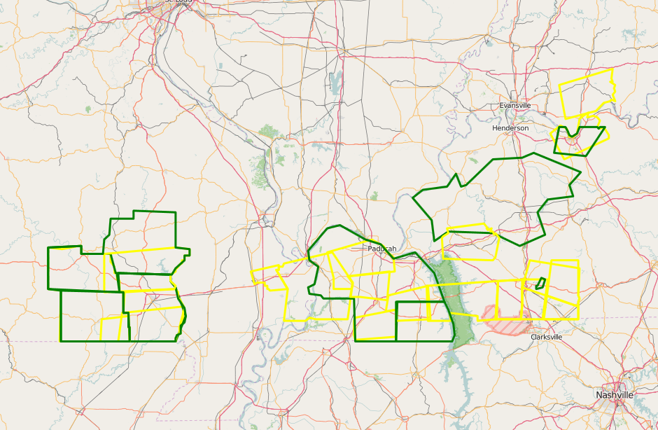
Graphic below shows all of the warnings overlayed on top of each other. Yellow are Severe Thunderstorm Warnings, while green are Flash Flood Warnings.

Storm Reports
Graphic below shows the location of all storm reports received from this event. (Click on image to enlarge it)

..TIME...   ...EVENT...      ...CITY LOCATION...     ...LAT.LON...
..DATE...   ....MAG....      ..COUNTY LOCATION..ST.. ...SOURCE....
            ..REMARKS..

0800 AM     TSTM WND GST     OWENSBORO               37.76N 87.12W
07/08/2016  M61.00 MPH       DAVIESS            KY   AWOS

0802 AM     TSTM WND DMG     OWENSBORO               37.76N 87.12W
07/08/2016                   DAVIESS            KY   EMERGENCY MNGR

            LATE REPORT. OLDER WOOD BARN BLOWN DOWN ALONG CURDSVILLE
            DELAWARE ROAD.

0803 AM     TSTM WND DMG     9 W OWENSBORO           37.76N 87.28W
07/08/2016                   DAVIESS            KY   TRAINED SPOTTER

            LARGE TREE FELL AND DAMAGED ROOF AWNING ON APARTMENT
            BUILDING.

0808 AM     HAIL             UTICA                   37.61N 87.11W
07/08/2016  M0.75 INCH       DAVIESS            KY   EMERGENCY MNGR

            LATE REPORT. DIME SIZE HAIL REPORTED.

0810 AM     TSTM WND DMG     OWENSBORO               37.76N 87.12W
07/08/2016                   DAVIESS            KY   FIRE DEPT/RESCUE

            WIDESPREAD TREE DAMAGE WITH SOME HOMES DAMAGED THROUGHOUT
            THE COMMUNITY. REPORTED BY FIRE CHIEF WHILE RESPONDING.

0435 PM     TSTM WND DMG     VAN BUREN               37.01N 91.01W
07/08/2016                   CARTER             MO   LAW ENFORCEMENT

            NUMEROUS TREES DOWN AND A POWER LINE DOWN.

0437 PM     TSTM WND GST     VAN BUREN               37.01N 91.01W
07/08/2016  E50.00 MPH       CARTER             MO   TRAINED SPOTTER

0506 PM     HEAVY RAIN       POPLAR BLUFF            36.76N 90.41W
07/08/2016  M0.86 INCH       BUTLER             MO   TRAINED SPOTTER

            30 MINUTE RAINFALL ACCUMULATION

0510 PM     TSTM WND DMG     ELLSINORE               36.93N 90.75W
07/08/2016                   CARTER             MO   LAW ENFORCEMENT

            NUMEROUS TREES DOWN. BETWEEN 50 TO 60 PHONE CALLS TO
            SHERIFFS OFFICE REGARDING TREES DOWN IN CARTER COUNTY.

0514 PM     HEAVY RAIN       7 NW POPLAR BLUFF       36.84N 90.50W
07/08/2016  M1.35 INCH       BUTLER             MO   TRAINED SPOTTER

            MEASURED IN JUST OVER AN HOUR WITH ONE QUARTER INCH
            FALLING IN THE PAST 7 MINUTES.

0525 PM     TSTM WND DMG     POPLAR BLUFF            36.76N 90.41W
07/08/2016                   BUTLER             MO   TRAINED SPOTTER

            LARGE TREE DOWN. WIND GUST ASSOCIATED WITH THIS STORM WAS
            MEASURED AT 47 MPH.

0527 PM     HEAVY RAIN       2 E POPLAR BLUFF        36.76N 90.37W
07/08/2016  M1.59 INCH       BUTLER             MO   TRAINED SPOTTER

0550 PM     TSTM WND DMG     ANNISTON                36.82N 89.33W
07/08/2016                   MISSISSIPPI        MO   LAW ENFORCEMENT

            TREES DOWN.

0610 PM     TSTM WND GST     BARDWELL                36.87N 89.01W
07/08/2016  E60.00 MPH       CARLISLE           KY   PUBLIC

0613 PM     TSTM WND GST     WICKLIFFE               36.97N 89.08W
07/08/2016  E60.00 MPH       BALLARD            KY   EMERGENCY MNGR

0613 PM     TSTM WND GST     WICKLIFFE               36.97N 89.08W
07/08/2016  E60.00 MPH       BALLARD            KY   TRAINED SPOTTER

0613 PM     TSTM WND GST     BARDWELL                36.87N 89.01W
07/08/2016  E70.00 MPH       CARLISLE           KY   PUBLIC

0615 PM     TSTM WND DMG     BLANDVILLE              36.94N 88.96W
07/08/2016                   BALLARD            KY   EMERGENCY MNGR

            REPORTS OF MULTIPLE TREES DOWN ACROSS SOUTHERN BALLARD
            COUNTY FROM JUST EAST OF WICKLIFFE TOWARD LOVELACEVILLE,
            MAINLY SOUTH OF HWY 286.

0616 PM     TSTM WND DMG     BLANDVILLE              36.94N 88.96W
07/08/2016                   BALLARD            KY   EMERGENCY MNGR

            UPROOT TREE BLOCKING HIGHWAY 121 NEAR THE BALLARD
            CARLISLE COUNTY LINE.

0620 PM     TSTM WND DMG     FOLSOMDALE              36.88N 88.67W
07/08/2016                   GRAVES             KY   LAW ENFORCEMENT

            SEVERAL REPORTS OF TREES DOWN ACROSS NORTHERN HALF OF
            GRAVES COUNTY INCLUDING IN THE TOWNS OF HICKORY, FANCY
            FARM, MELBER, AND FOLSOMDALE AROUND 615 TO 630PM.

0625 PM     TSTM WND DMG     MAYFIELD                36.74N 88.65W
07/08/2016                   GRAVES             KY   LAW ENFORCEMENT

            POWER LINES DOWN AND STOP LIGHTS OUT IN MAYFIELD

0628 PM     TSTM WND DMG     WINGO                   36.64N 88.74W
07/08/2016                   GRAVES             KY   PUBLIC

            PORTION OF LARGE TREE BLOWN ONTO RESIDENCE PROPERTY.

0628 PM     TSTM WND DMG     WINGO                   36.64N 88.74W
07/08/2016                   GRAVES             KY   PUBLIC

            LARGE OAK TREE UPROOTED

0630 PM     TSTM WND DMG     2 N CUBA                36.59N 88.64W
07/08/2016                   GRAVES             KY   PUBLIC

            TREE LIMBS DOWN ALONG STATE ROUTE 303

0632 PM     TSTM WND DMG     PADUCAH                 37.07N 88.64W
07/08/2016                   MCCRACKEN          KY   PUBLIC

            POWER POLE DOWN ON HUSBANDS ROAD BETWEEN HOMEWOOD AND
            HOVEKAMP ROADS.

0632 PM     TSTM WND DMG     PADUCAH                 37.07N 88.64W
07/08/2016                   MCCRACKEN          KY   PUBLIC

            LARGE TREE OVER HUSBANDS ROAD.

0635 PM     TSTM WND GST     MAYFIELD                36.74N 88.65W
07/08/2016  M53.00 MPH       GRAVES             KY   AWOS

0650 PM     TSTM WND DMG     ALMO                    36.69N 88.28W
07/08/2016                   CALLOWAY           KY   BROADCAST MEDIA

            MULTIPLE TREES UPROOTED.

0650 PM     TSTM WND DMG     ALMO                    36.69N 88.28W
07/08/2016                   CALLOWAY           KY   TRAINED SPOTTER

            TREES DOWN ON NEARLY EVERY ROAD IN THE DEXTER/ALMO AREA.


0703 PM     TSTM WND GST     2 N HOPKINSVILLE        36.88N 87.49W
07/08/2016  E58.00 MPH       CHRISTIAN          KY   TRAINED SPOTTER

            DIME SIZE HAIL REPORTED WITH THIS STORM AS WELL.

0710 PM     HAIL             ALMO                    36.69N 88.28W
07/08/2016  M0.88 INCH       CALLOWAY           KY   EMERGENCY MNGR

            NICKEL SIZE HAIL REPORTED.

0715 PM     TSTM WND DMG     LINTON                  36.69N 87.92W
07/08/2016                   TRIGG              KY   BROADCAST MEDIA

            MULTIPLE TREES DOWN ON LINTON ROAD.

0720 PM     FLASH FLOOD      PADUCAH                 37.07N 88.64W
07/08/2016                   MCCRACKEN          KY   TRAINED SPOTTER

            WATER OVER MAXON ROAD NORTH OF HARRIS ROAD.

0735 PM     TSTM WND GST     CALEDONIA               36.82N 87.69W
07/08/2016  M56.00 MPH       TRIGG              KY   TRAINED SPOTTER

0737 PM     TSTM WND DMG     HOPKINSVILLE            36.85N 87.49W
07/08/2016                   CHRISTIAN          KY   EMERGENCY MNGR

            NUMEROUS TREES DOWN. MADISONVILLE ROAD AND HWY 189 ARE
            BLOCKED. BARN LEVELED. WIDESPREAD POWER OUTAGES REPORTED
            ACROSS THE NORTHERN HALF OF THE COUNTY.

0740 PM     FLASH FLOOD      BARLOW                  37.05N 89.05W
07/08/2016                   BALLARD            KY   EMERGENCY MNGR

            SEVERAL REPORTS OF FLOODED ROADWAYS THROUGHOUT THE
            COUNTY.

0740 PM     TSTM WND DMG     2 E HOPKINSVILLE        36.85N 87.45W
07/08/2016                   CHRISTIAN          KY   BROADCAST MEDIA

            TREE DOWN ON POWER LINE ON PLUM STREET AND ANOTHER TREE
            DOWN ON ANNETT COURT ON EAST SIDE OF TOWN. AROUND 2500
            CUSTOMERS ARE WITHOUT POWER IN CHRISTIAN COUNTY.

0803 PM     TSTM WND DMG     GREENVILLE              37.21N 87.18W
07/08/2016                   MUHLENBERG         KY   LAW ENFORCEMENT

            WIDESPREAD TREES DOWN THROUGHOUT THE COUNTY. POWER LINES
            DOWN IN GREENVILLE. NEAR CONTINUOUS LIGHTNING.

0814 PM     TSTM WND DMG     ELKTON                  36.81N 87.16W
07/08/2016                   TODD               KY   LAW ENFORCEMENT

            TWO TREES DOWN IN ELKTON WITH WINDS AT 60 MPH.
Rain Reports
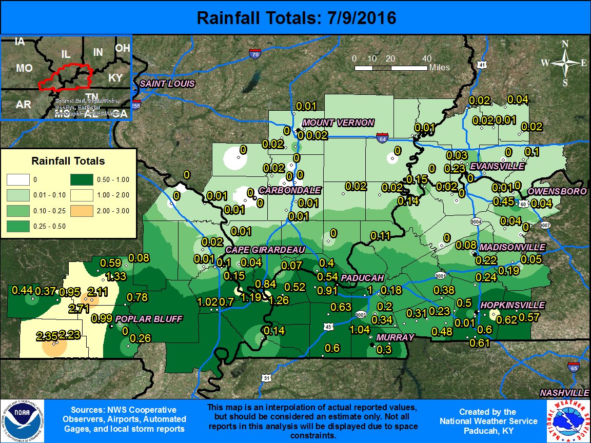
Heaviest rainfall totals from this event were located over portions of southeast MO, particularly the Ozark foothill area, where upwards of 2+ inches came down. Amounts were generally less over western KY, due to the faster progression of the storms, but some areas still saw locally 1 inch or more. Note that the map interpolates amounts in between observations points, so some areas may have gotten more or less than the map shows.
(Click on image to enlarge it)

Environment
A mid level shortwave trough was moving thru the Great Lakes region during the day. The lower Ohio Valley was on the southwest side of the stronger mid-level flow with winds around 35kts where the storms formed and moved thru. On the 700mb surface, you can see a weak disturbance over southwest MO/northwest AR which helped focus organized convection ahead of it. A weak surface front resided just north of our area across portions of MO and IL at 4pm. Strong instability existed with MLCAPE's above 3000 J/kg along with steep mid level lapse rates around 6.5 to 7.5 degrees C/km. Precipitable water values were also quite high, around 2 inches. This resulted in heavy rainfall and some flash flooding where storms trained over the same location. With the area already hit hard by heavy rain and thunderstorms the past couple of days, it didn't take much to produce flooding in some locations.
Atmospheric set-up above the surface...
 |
 |
 |
| 500mb(~18,000ft) at 4PM CDT | 700mb(~10,000ft) at 4PM CDT | 850mb(~5,000ft) at 4PM CDT |
Surface environment and moisture...
 |
 |
 |
| Mean Sea Level Pressure at 4PM CDT | SFC Temps/Dewpoints at 4PM CDT | Precip Water at 4PM CDT |
Instability parameters...
 |
 |
 |
| MLCAPE at 4PM CDT | Downdraft CAPE at 4PM CDT | Mid Level Lapse Rates at 4PM CDT |
 |
Media use of NWS Web News Stories is encouraged! Please acknowledge the NWS as the source of any news information accessed from this site. |
 |