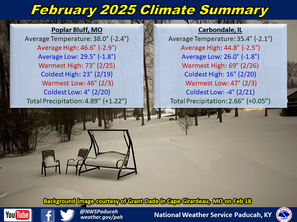
February 2025 Climate Review:
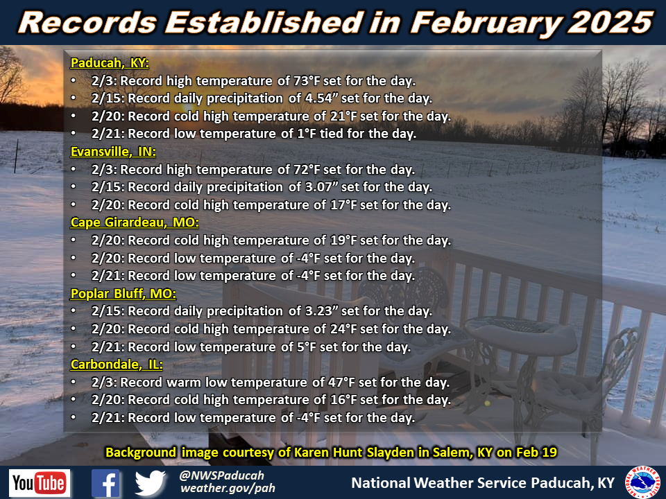
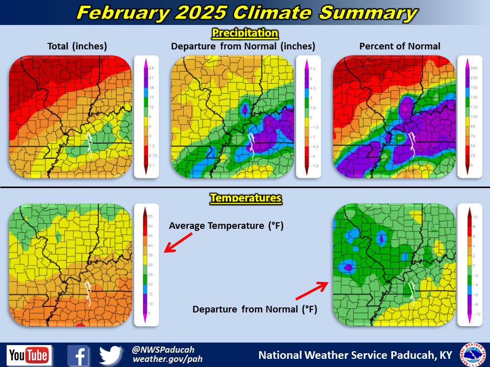
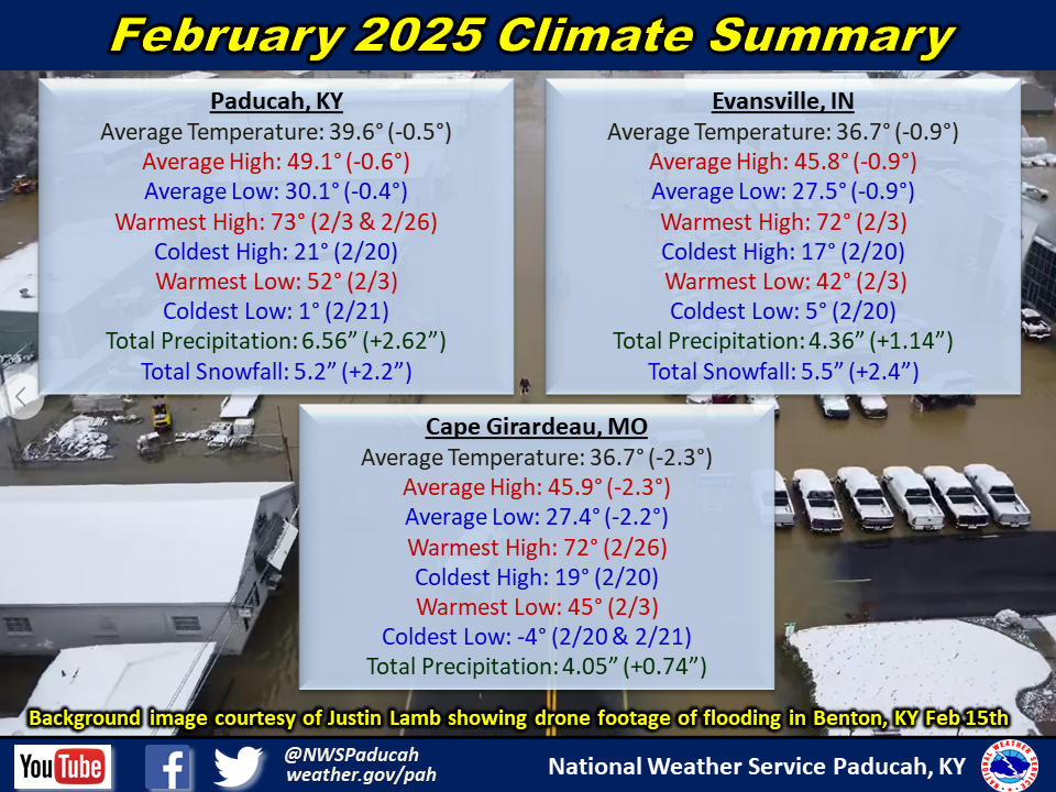
Temperatures finished below normal by 0.5 to 2 degrees. We experienced exceptional warmth for the first 8 days of the month (Paducah ended up registering their warmest first 8 days of February on record). Most days reached the 50s or 60s during this stretch, but record warmth in the low to mid 70s was experienced for parts of the region on the 3rd. The month turned significantly colder with below normal temperatures from the 9th through 23rd. A brutal blast of arctic air swept across the region from the 17th through 21st. Highs remained in the teens or 20s, with overnight lows falling into the single digits a few nights. Even a few sub-zero readings were experienced, mainly across southeast Missouri and southern Illinois. Cape Girardeau fell to -4 degrees on the 21st, which is their 2nd latest occurrence of a sub-zero temperature on record (only March 6, 2015 was later in the year). Wind chills of -5 to -10 were experienced across most of the region on the morning of the 19th, with localized colder readings down to -15. Temperatures rebounded quickly back to above normal for the 24th through 28th with highs back into the 60s and even 70s for portions of the area. It’s certainly not every month you get a 72 degree spread in temperatures which was experienced in Paducah! In fact, this is only the 6th time we’ve witnessed a 70+ degree spread in temperatures in one month since 1998.
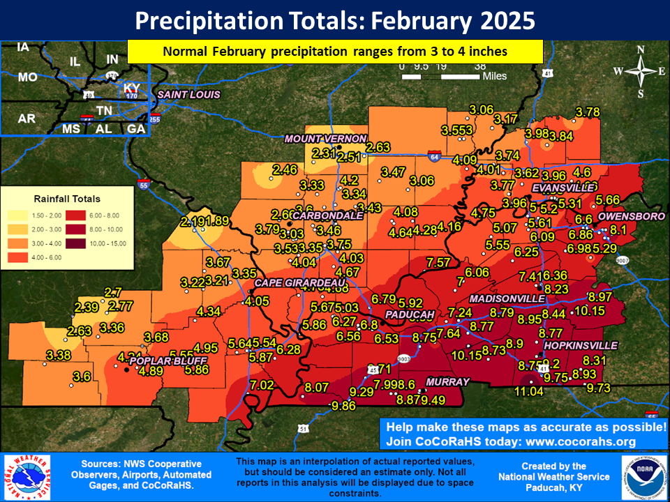
Precipitation averaged wetter than normal across most of the Quad State region. There was a significant range in amounts from less than 3” in parts of the Ozark Foothills and north of I-64 in southern Illinois to over 9” in parts of west Kentucky. Most of the area finished anywhere from 1 to 6 inches wetter than normal, with the greatest departures realized across west Kentucky. The highest observed amount was 11.04” at a COOP station near Herndon, KY (Christian County). Roughly 50 to 75 percent of the monthly rainfall occurred on the 16th when widespread amounts of 2 to 7 inches were observed. This led to widespread flash flooding including numerous water rescues and road closures across west Kentucky.
There were 2 winter weather events to impact the region this month. The first occurred on the backside of the system that brought the major flooding to the region on the 15th, with temperatures falling overnight into early morning on the 16th. A band of heavier snow moved across the area producing a quick 1 to 3 inch accumulation of very wet snow. It certainly left many across the region baffled the next morning, waking up to the landscape covered in white instead of standing water in their backyards! This was followed a couple of days later by another winter storm that produced widespread snow amounts of 2 to 7 inches across the area from the afternoon of the 18th through the morning of the 19th. Localized higher amounts up to 11 inches were observed across southeast Missouri.
The graphic below is an estimated multi-radar, multi-sensor (MRMS) monthly rainfall map using a combination of radar estimates and actual observations. Please note that actual rainfall observed at any location may vary slightly due to potential error in radar estimation and observation interpolation.
| February 2025 Review: Precipitation and Temperature Maps (Click on image to enlarge) |
 |
| Climate Maps are from the Northeast Regional Climate Center |
Monthly Climate Report: Paducah | Evansville | Cape Girardeau | Poplar Bluff | Carbondale