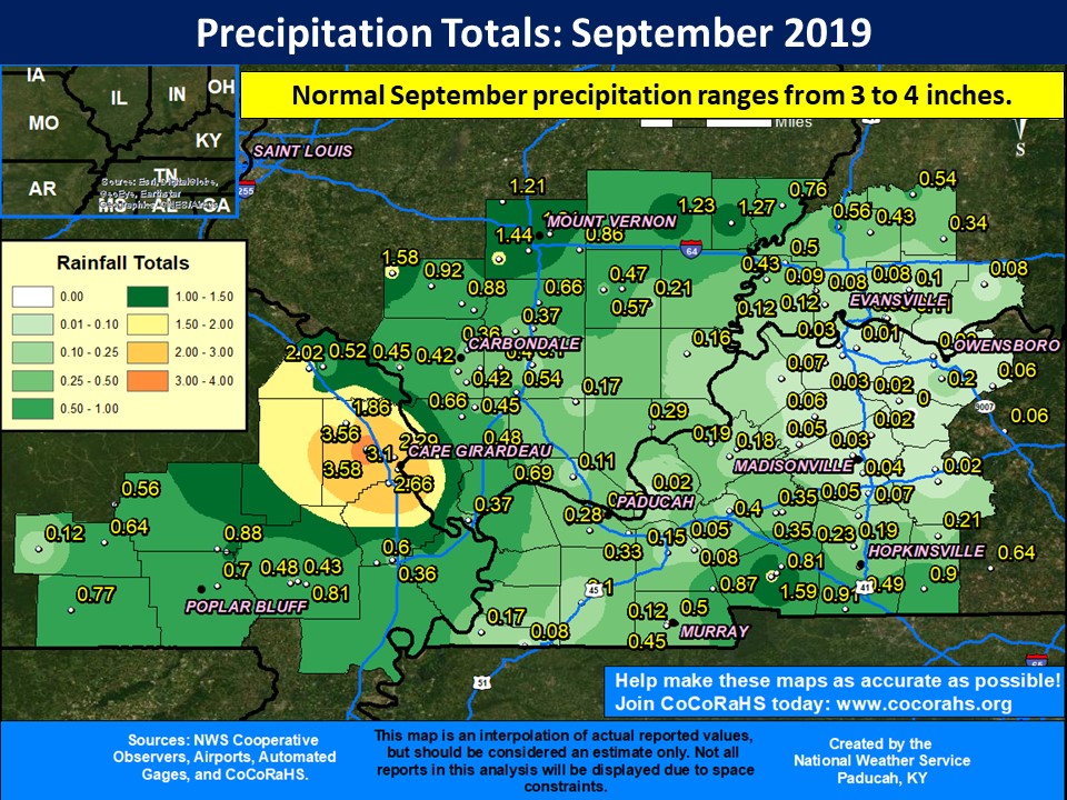
After an excessively wet start to the year, a drier weather pattern abruptly took hold of our region beginning the last 5 days in August and continued into early October. This was the worst drought to affect western Kentucky since November 2016. September was a very dry month, particularly across western Kentucky, southeast Illinois, and southwest Indiana. Several locations observed their driest September on record, including Evansville, which received a whopping 0.08” the entire month! There were numerous locations that received a tenth of an inch or less, especially in the northern Pennyrile region of western Kentucky. The streak of 12 consecutive months with above normal precipitation came to an abrupt end in Paducah, as we only picked up 0.32”. This was the 4th driest September on record in Paducah, and the driest month since October 2005.
Paducah went 29 days without measurable rain from August 27 through September 24. This was the longest dry spell since September 1999 and the 8th longest dry spell on record, dating back to 1937.
The graphic below is an interpolated rainfall map using actual observations. Please note that there are likely discrepancies in between observations, since the values are estimated based on nearest reports. (Ex: Estimates in Bollinger County Missouri appear too high, but we have no observations from that county.)
 |
 |
 |
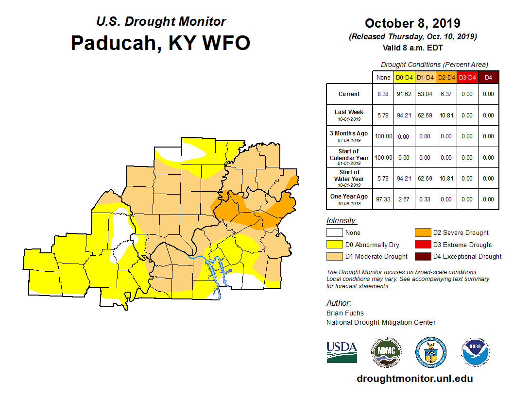 |
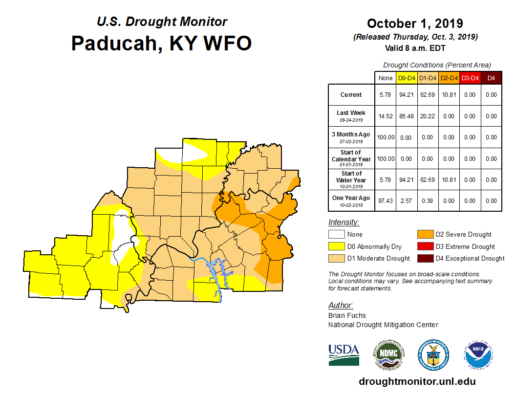
DROUGHT INFORMATION STATEMENT
NATIONAL WEATHER SERVICE PADUCAH KY
1049 AM CDT THU OCT 10 2019

...SEVERE DROUGHT CONTINUES ACROSS PARTS OF WEST KENTUCKY AND NOW
SOUTHWEST INDIANA...

SYNOPSIS...

SEVERE DROUGHT /D2/ REMAINS ACROSS PARTS OF WEST KENTUCKY
INCLUDING PORTIONS OF UNION, HENDERSON, DAVIESS, MCLEAN, WEBSTER
AND HOPKINS COUNTIES. IN SOUTHWEST INDIANA PARTS OF POSEY AND
SPENCER HAVE BEEN DEGRADED.

MODERATE DROUGHT /D1/ COVERS ALL OF THE REST OF SOUTHWEST
INDIANA, MOST OF SOUTHERN ILLINOIS, AND MOST OF THE REST OF WEST
KENTUCKY.

ABNORMALLY DRY /D0/ CONDITIONS COVER THE REMAINDER OF SOUTHERN
ILLINOIS, WEST KENTUCKY, AND SOUTHEAST MISSOURI.


SUMMARY OF IMPACTS...

SOIL MOISTURE CONDITIONS.
A LACK OF PRECIPITATION HAS CAUSED SOIL MOISTURE TO DECREASE
RAPIDLY FROM LATE AUGUST THROUGH SEPTEMBER. OVER 50% OF TOPSOIL
AND SUBSOIL ACROSS WEST KENTUCKY AND SOUTHWEST INDIANA IS
CONSIDERED SHORT OR VERY SHORT.

AGRICULTURAL IMPACTS.
PASTURE LAND CONDITIONS HAVE BEGUN TO DETERIORATE AND THERE ARE
REPORTS OF EARLY HAY FEEDING ESPECIALLY ACROSS KENTUCKY. STOCK
PONDS ARE BEGINNING TO RUN LOW IN SOME AREAS.

FIRE DANGER IMPACTS.
BURN BANS ARE IN EFFECT ACROSS ALL OF SOUTHWEST INDIANA AND WEST
KENTUCKY EXCLUDING THE COUNTIES OF CARLISLE, CHRISTIAN AND TRIGG.
OTHER LOCAL BURN BANS MAY BE IN EFFECT IN SOUTHERN ILLINOIS.
ALWAYS CHECK WITH LOCAL OFFICIALS BEFORE BURNING.


CLIMATE SUMMARY...
RAIN FELL LATE LAST WEEK ACROSS THE REGION. PARTS OF SOUTHEAST
MISSOURI AND THE SOUTHERN PENNYRILE REGION OF WEST KENTUCKY RECEIVED
THE MOST RAIN WITH ONE-HALF UP TO AROUND ONE INCH RECORDED. OTHER
AREAS WEREN'T SO LUCK WITH ONLY TWO- TO THREE-TENTHS OF AN INCH
FALLING.


