
Isolated heavy rainfall will continue through tonight across portions of central Texas, though some relief from the heavy rain is expected on Tuesday. Heat and humidity will remain in place across the Eastern U.S. and interior Northwest U.S. over the next few days with widespread moderate to major Heat Risk. Dangerous heat will build into the Desert Southwest Tuesday through Thursday. Read More >
Fall 2022 Climate Summary: Temperatures averaged near to slightly below normal for the season. We experienced a larger diurnal range than normal due to the drought in place. High temperatures actually were around 1 to 2 degrees above normal, but lows were 2 to 3 degrees below normal. The warmest month compared to normal was September which finished near to slightly above normal by around a half degree. October was the coldest month compared to normal with temperatures averaging around 1 to 1.5 degrees below normal. A rare late season heat wave occurred September 20-21. Paducah and Cape Girardeau hit 100 degrees, which was the latest on record for temperatures this hot in either city. October was known for it’s wide diurnal ranges due to the dry conditions, with temperature swings of 30 to 40 degrees between lows and highs common. November started off with unusually warm temperatures during the first 10 days, but we quickly flipped the switch to more of a January-like feel from the 11th through 21st. An early season snowstorm struck the region during the early morning hours on November 12th and produced a swath of 1 to 3 inches in many areas. This was the first time in recorded history that Paducah observed measurable snow within 3 days of temperatures reaching 80 degrees.
The lingering summer drought worsened throughout the fall season with moderate to severe drought across the entire area by the latter half of November. Precipitation amounts were only between 3 and 7 inches in most locations, which was 4 to 9 inches below seasonal norms. It was the 2nd driest fall on record in Carbondale, 3rd driest in Cape Girardeau, and 4th driest in Paducah. It was the driest fall since 1939 in Carbondale. Evansville was among the areas that received the most rainfall for the season, largely due to excessive rainfall of nearly 4.5” on September 3rd. Over half of their fall precipitation fell on that one day!
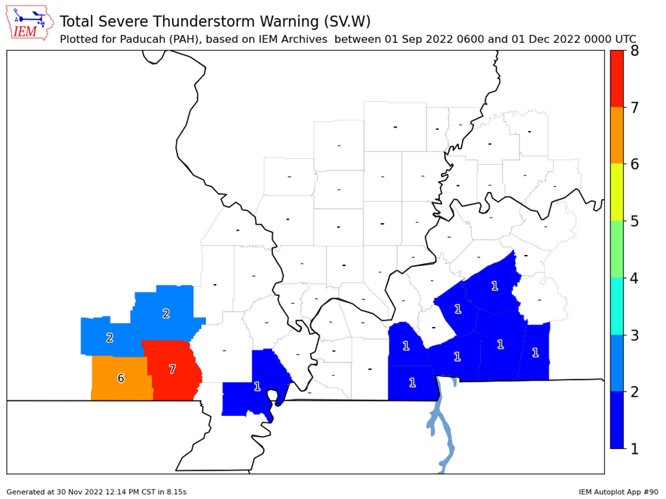
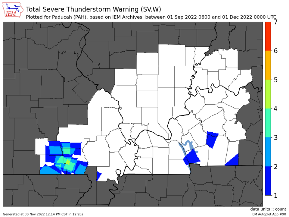
We only issued 11 combined severe thunderstorm and tornado warnings for our 58 county forecast area during the fall (all of which were severe thunderstorm warnings). This was well below the average of 33 warnings that are typically issued during the fall season.
The graphic below is an interpolated rainfall map using actual observations. Please note that there are likely discrepancies in between observations, since the values are estimated based on nearest reports.
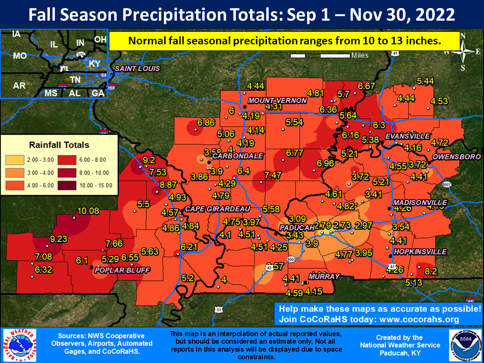
| Fall 2022 Review: Precipitation and Temperature Maps (Click on image to enlarge) |
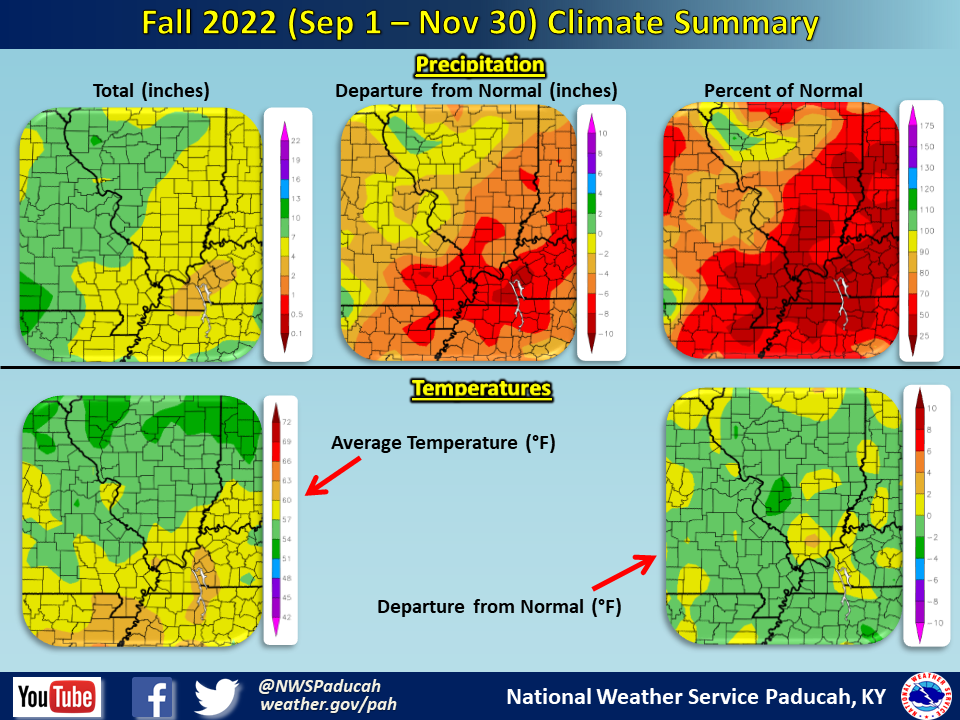 |
| Climate Maps are from the Northeast Regional Climate Center |


| Severe Thunderstorm Warnings - County Based | Severe Thunderstorm Warnings - Polygon Based |
 |
 |
| Tornado Warnings - County Based | Tornado Warnings - Polygon Based |
|
No Tornado Warnings were issued |
No Tornado Warnings were issued |

