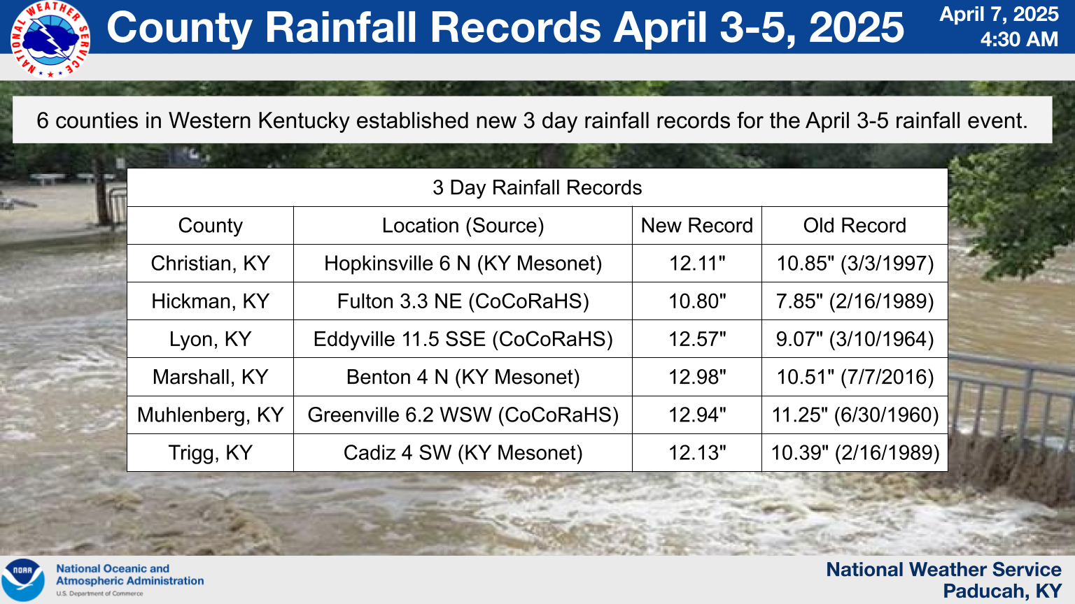
Overview
|
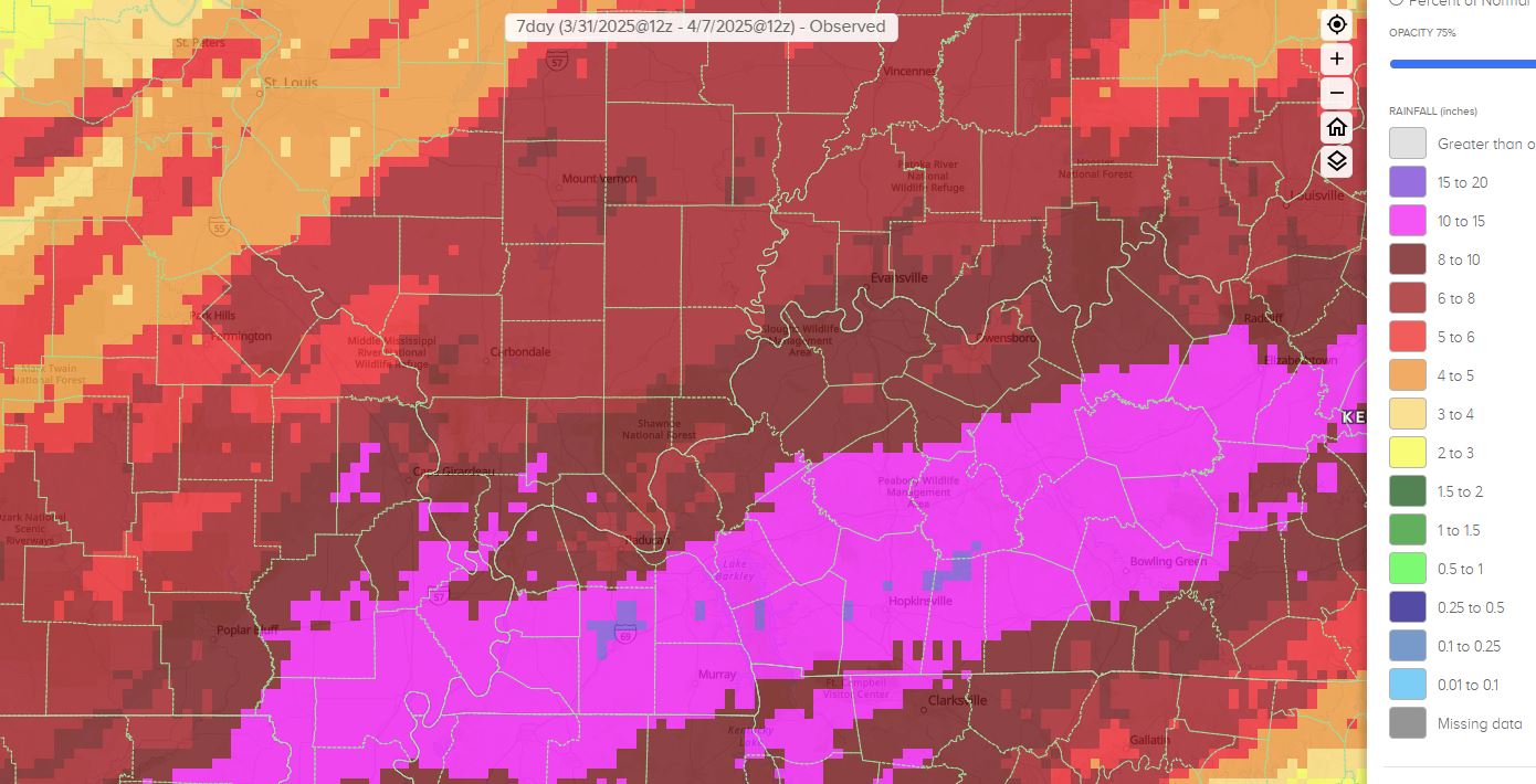
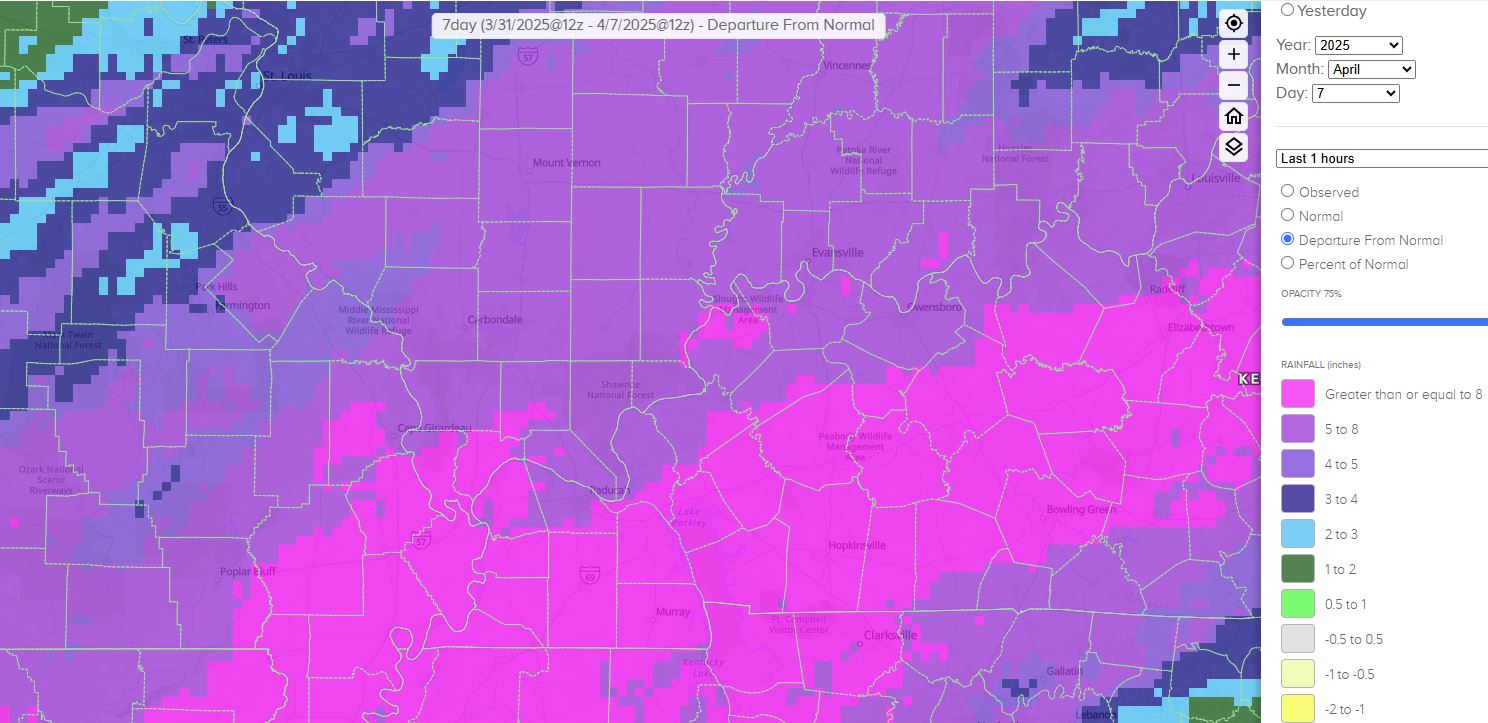
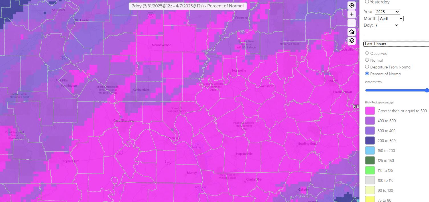
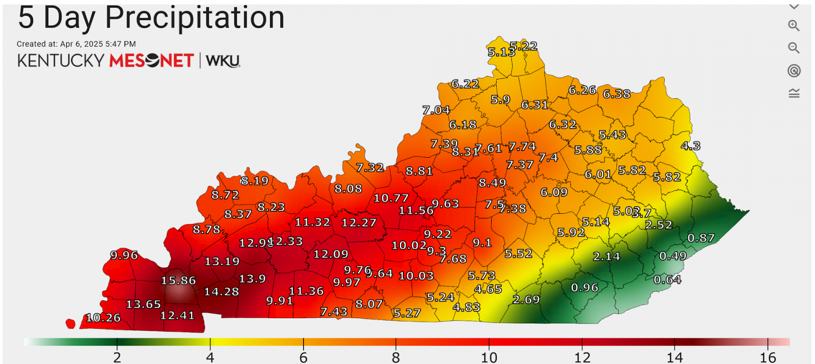
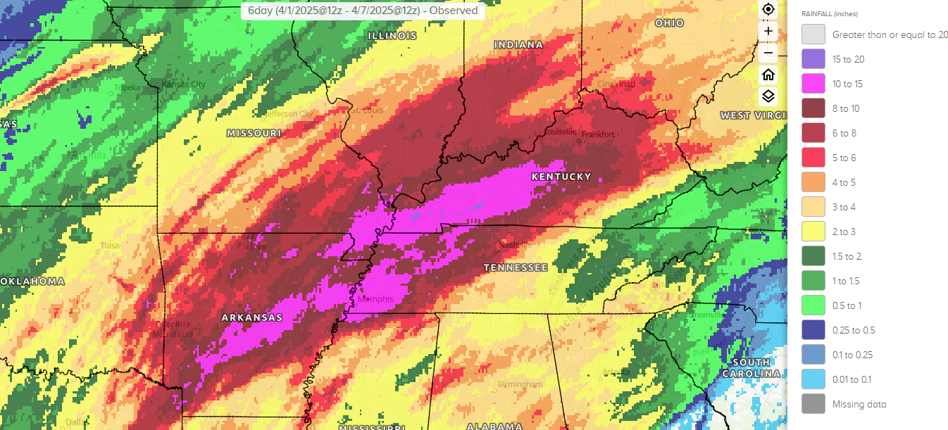
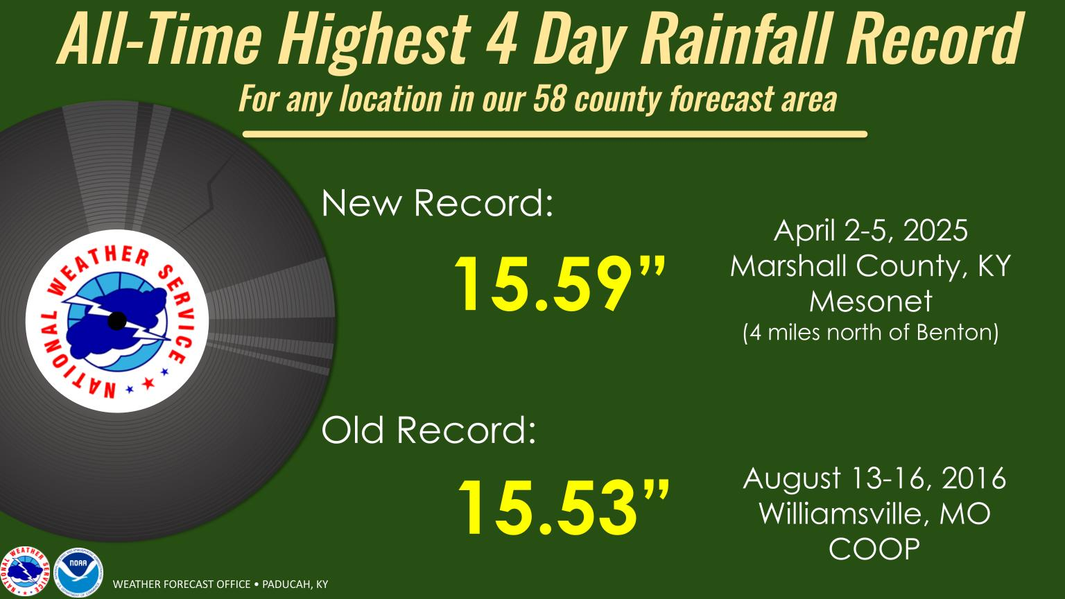
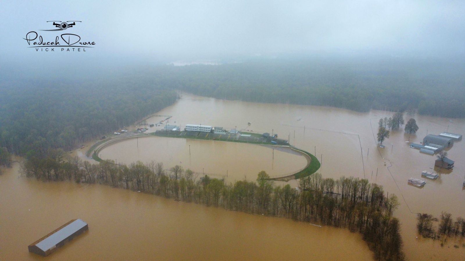
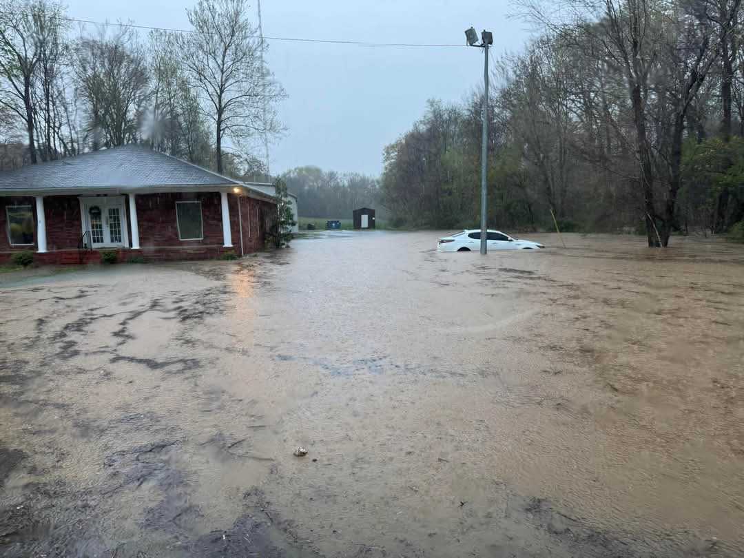
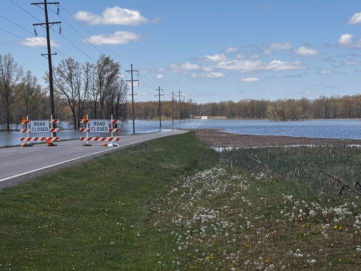
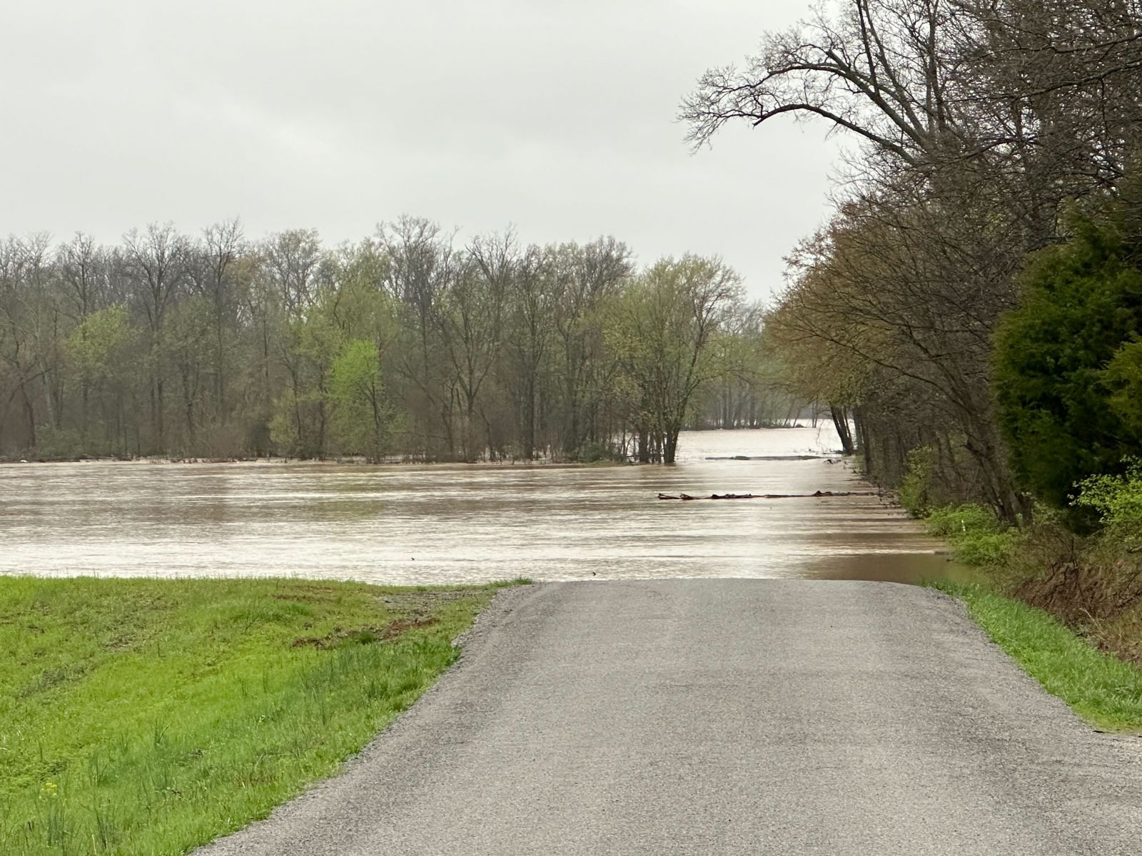
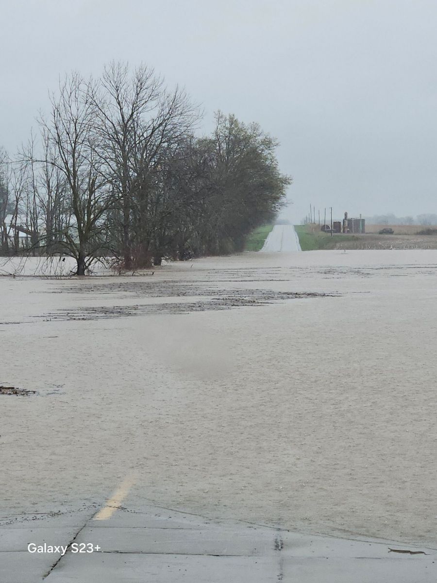
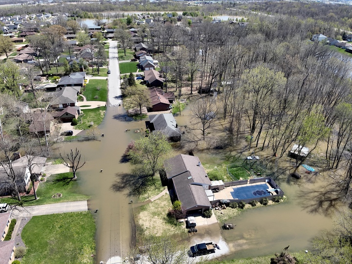
Multiple rounds of heavy rain and thunderstorms impacted the lower Ohio Valley beginning on the afternoon of April 2nd and continued through the evening of April 5th. Lighter showers continued through the day on April 6th. The first wave consisted of a significant severe thunderstorm event and tornado outbreak during the afternoon and evening on April 2nd. Flash flooding became a greater concern during the overnight as storms trained over the same locations. Additional waves of thunderstorms training over the same area continued over the next several days, with the heaviest falling from the evening of the 4th through the evening of the 5th. Widespread rainfall amounts of 6 to 12" were observed over this 4 day period, with a swath of 12 to 16" across western Kentucky. The Marshall County KY mesonet station received 15.59" of rain over a 4 day period, which broke the all-time highest 4 day rainfall record for any location in our 58 county forecast area. Flash Flooding impacted basically every one of our 58 counties in our forecast area at some point during this event. We issued Flash Flood Emergencies for Cape Girardeau and Carter Counties in Missouri on the evening of April 4th. Numerous water rescues occurred across the region with many homes and businesses inundated by flood waters. Countless roads were covered by high water and impassable, some of which still are closed weeks later due to ongoing major river flooding. |
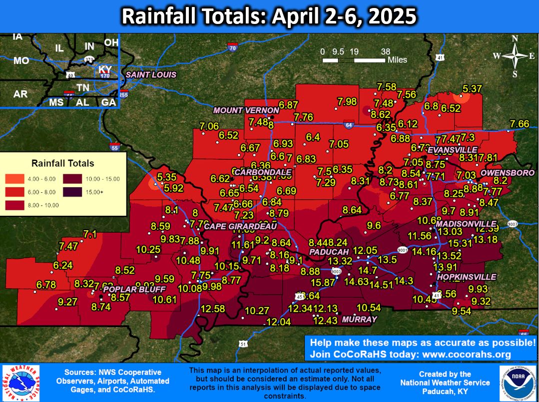 Observed Rainfall Totals Across Our Region |
Flooding
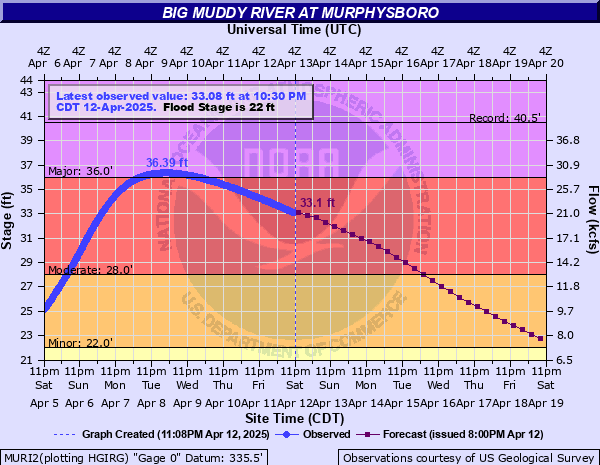
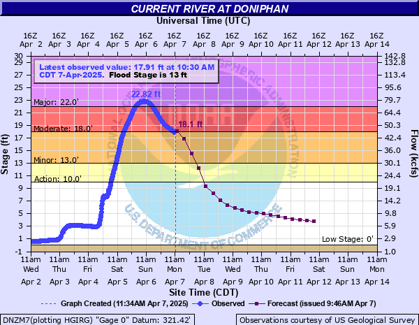
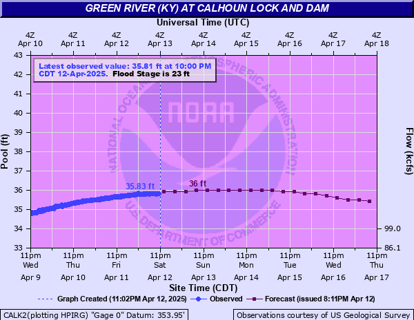
Hydrographs (Click on images to enlarge)
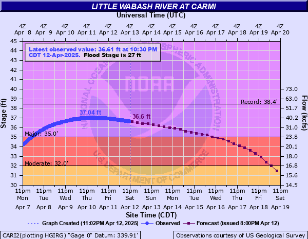
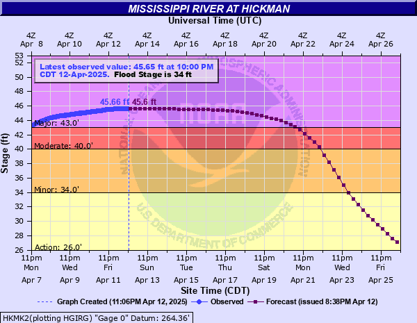
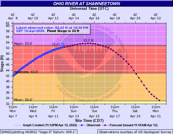
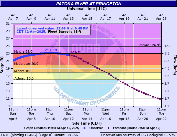
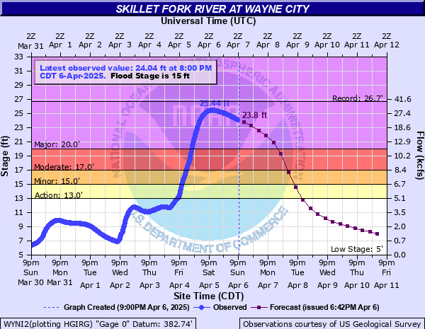
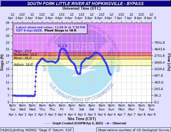
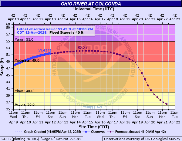
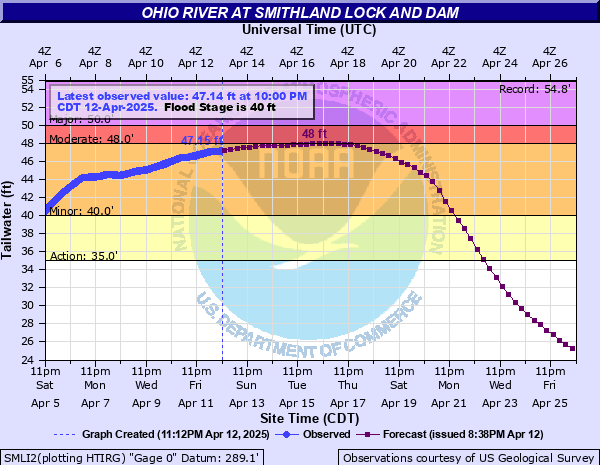
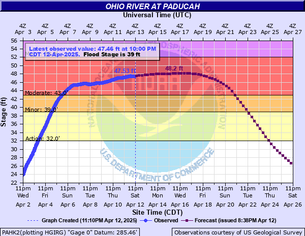
We forecast for 31 points along 12 different rivers across our 58 county forecast area. 26 of these reached at least moderate flood level during this event with 12 of them reaching major category.
Major Flooding at these locations:
 |
 |
 |
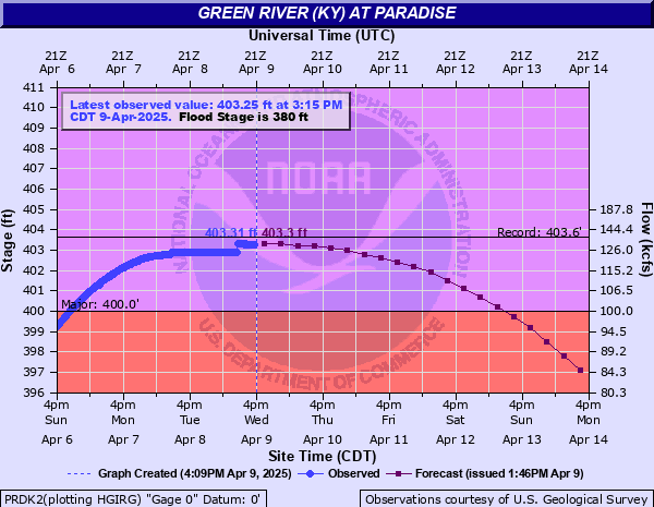 |
| Big Muddy River - Murphysboro, IL | Current River - Doniphan, MO | Green River - Calhoun, KY | Green River - Paradise, KY |
 |
 |
 |
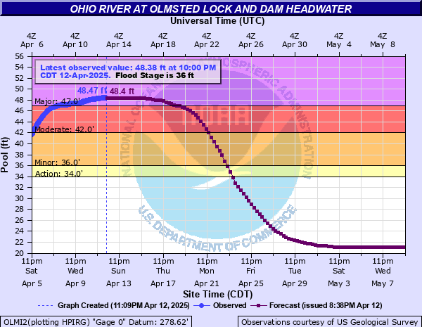 |
| Little Wabash River - Carmi, IL | Mississippi River - Hickman, KY | Ohio River - Shawneetown, IL | Ohio River - Olmsted Lock & Dam |
 |
 |
 |
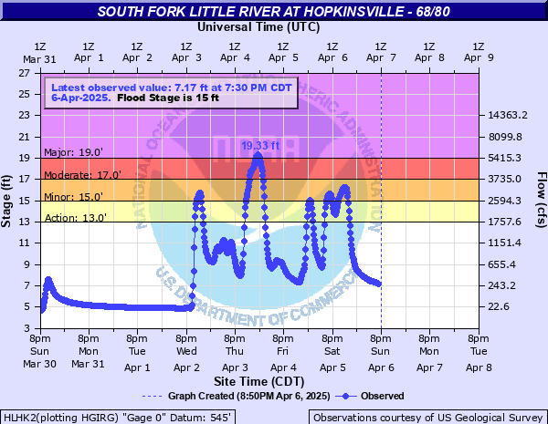 |
| Patoka River - Princeton, IN | Skillet Fork River - Wayne City, IL | South Fork Little River - Hopkinsville, KY Bypass | South Fork Little River - Hopkinsville, KY 68/80 |
Moderate Flooding at these locations:
 |
 |
 |
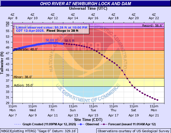 |
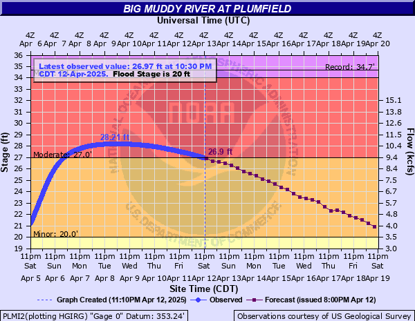
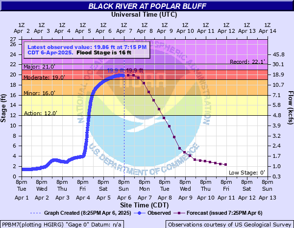
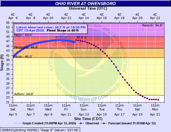
| Big Muddy River - Plumfield, IL | Black River - Poplar Bluff, MO | Ohio River - Owensboro, KY | Ohio River - Newburgh, IN |
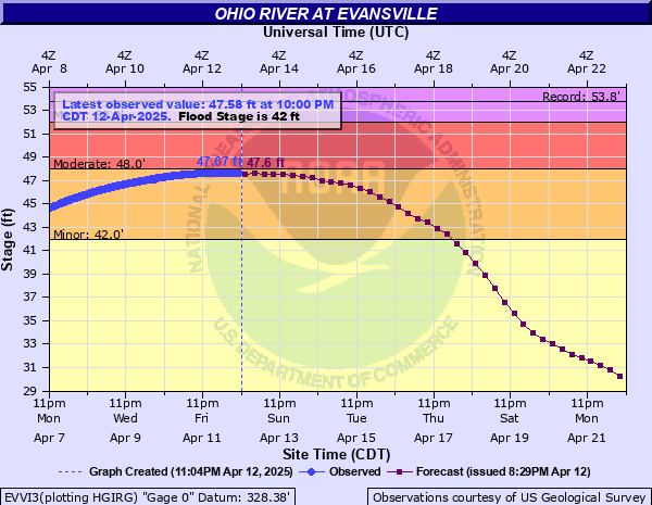 |
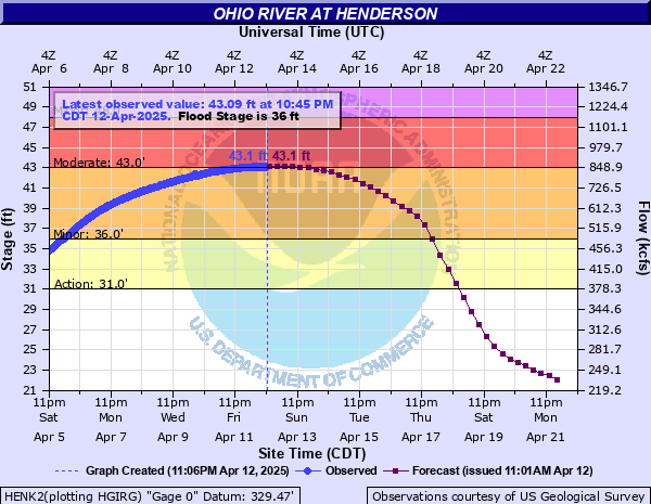 |
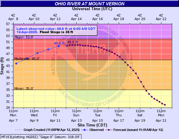 |
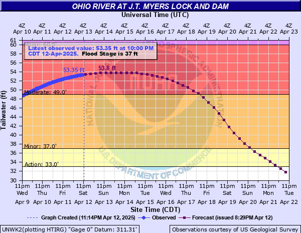 |
| Ohio River - Evansville, IN | Ohio River - Henderson, KY | Ohio River - Mt Vernon, IN | Ohio River - JT Myers Lock & Dam |
 |
 |
 |
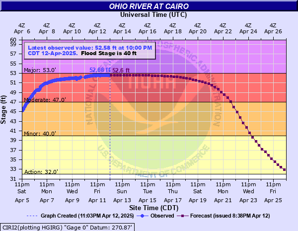 |
| Ohio River - Golconda, IL | Ohio River - Smithland, KY | Ohio River - Paducah, KY | Ohio River - Cairo, IL |
 |
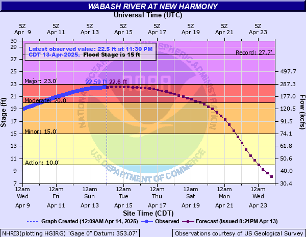 |
| St Francis River - Patterson, MO | Wabash River - New Harmony, IN |
**Please note that all of these crests are preliminary.
| Major Flooding | |||
| River | Location | Preliminary Crest | Highest Crest Since: |
| Big Muddy | Murphysboro, IL | 36.39 ft on April 9 | 38.56 ft on May 6, 2017 |
| Current | Doniphan, MO | 22.82 ft on April 6 | 33.13 ft on May 1, 2017 |
| Green | Calhoun, KY | 35.89 ft on April 13 | 36.30 ft on Jan 16, 1950 |
| Green | Paradise, KY | 403.31 ft on April 9 | 403.65 ft on Mar 5, 1962 |
| Little Wabash | Carmi, IL | 37.04 ft on April 11 | 38.34 ft on May 3, 2011 |
| Mississippi | Hickman, KY | 45.66 ft on April 12 | 45.85 ft on May 8, 2017 |
| Ohio | Shawneetown | 53.30 ft on April 15* | 56.36 ft on May 6, 2011 |
| Ohio | Olmsted Dam | 48.47 ft on April 12 | Records only go back to 2020 |
| Patoka | Princeton, IN | 23.19 ft on April 10 | 24.30 ft on May 6, 2017 |
| Skillet Fork | Wayne City, IL | 25.44 ft on April 6 | 25.75 ft on May 17, 1990 |
| South Fork Little River | Hopkinsville, KY Bypass | 21.20 ft on April 4 | 21.35 ft on Jul 7, 2016 |
| South Fork Little River | Hopkinsville, KY 68/80 | 19.33 ft on April 4 | 20.96 ft on Jul 7, 2016 |
| Moderate Flooding | |||
| River | Location | Preliminary Crest | Highest Crest Since: |
| Big Muddy | Plumfield, IL | 28.21 ft on April 9 | 28.62 ft on May 2, 2017 |
| Black River | Poplar Bluff, MO | 19.90 ft on April 6 | 21.96 ft on May 1, 2017 |
| Ohio | Owensboro, KY | 47.54 ft on April 11 | 49.00 ft on Mar 9, 1997 |
| Ohio | Newburgh, IN | 50.68 ft on April 11 | 50.90 ft on Mar 12, 1945 |
| Ohio | Evansville, IN | 47.67 ft on April 12 | 47.72 ft on Mar 16, 1964 |
| Ohio | Henderson, KY | 43.10 ft on April 12 | Records only go back to 2024 |
| Ohio | Mt Vernon, IN | 50.20 ft on April 14* | 51.80 ft on May 5, 2011 |
| Ohio | JT Myers Dam | 54.03 ft on April 14* | 56.92 ft on May 6, 2011 |
| Ohio | Golconda, IL | 52.50 ft on April 15* | 52.66 ft on Mar 4, 2018 |
| Ohio | Smithland, KY | 48.00 ft on April 16* | 51.83 ft on Feb 25, 2019 |
| Ohio | Paducah, KY | 48.50 ft on April 16* | 48.39 ft on Feb 21, 2020 |
| Ohio | Cairo, IL | 52.68 ft on April 12 | 56.51 ft on Mar 1, 2019 |
| Saint Francis | Patterson, MO | 28.76 ft on April 5 | 37.13 ft on Apr 30, 2017 |
| Wabash | New Harmony, IN | 22.6 ft on April 14* | 23.67 ft on May 4, 2011 |
Rain Reports
Click on images to enlarge:
 |
 |
 |
| April 1-7 Rainfall Totals | April 1-7 Departure from Normal Rainfall | April 1-7 Percent of Normal Rainfall |
 |
 |
| Rainfall Totals from Kentucky Mesonet | Regional Map of Rainfall Totals |
Quick links: Illinois | Indiana | Kentucky | Missouri
Illinois Rainfall Totals - April 1-7
| Station Name | Source | County | Total Precipitation |
| VILLA RIDGE 2.1 ESE | CoCoRaHS | Pulaski | 11.61 |
| ULLIN 0.4 WSW | CoCoRaHS | Pulaski | 11.09 |
| CYPRESS 1.4 WSW | CoCoRaHS | Johnson | 10.5 |
| CAIRO 0.8 N | CoCoRaHS | Alexander | 9.71 |
| METROPOLIS 2.9 NNE | CoCoRaHS | Massac | 9.36 |
| NEW GRAND CHAIN 1.1 NNW | CoCoRaHS | Pulaski | 9.32 |
| OLMSTED LOCK AND DAM | COOP | Pulaski | 9.2 |
| VIENNA 5.3 NNW | CoCoRaHS | Johnson | 8.79 |
| ELIZABETHTOWN | COOP | Hardin | 8.64 |
| ALBION 0.2 SW | CoCoRaHS | Edwards | 8.62 |
| BROOKPORT 7.3 ENE | CoCoRaHS | Massac | 8.44 |
| SHAWNEETOWN 3 WSW | COOP | Gallatin | 8.31 |
| SMITHLAND LOCK & DAM | COOP | Pope | 8.24 |
| MOUNT VERNON 5.2 SSW | CoCoRaHS | Jefferson | 8 |
| MURPHYSBORO 2.8 NNE | CoCoRaHS | Jackson | 7.98 |
| 1 ENE FAIRFIELD | COOP | Wayne | 7.98 |
| BELLE RIVE 1.7 NNE | CoCoRaHS | Jefferson | 7.76 |
| MOUNT VERNON 1.3 WSW | CoCoRaHS | Jefferson | 7.75 |
| DE SOTO 0.3 ESE | CoCoRaHS | Jackson | 7.68 |
| CHRISTOPHER 1.1 NNW | CoCoRaHS | Franklin | 7.62 |
| WEST SALEM 0.2 E | CoCoRaHS | Edwards | 7.58 |
| MOUNT CARMEL 4.2 NW | CoCoRaHS | Wabash | 7.56 |
| GOREVILLE 3.8 NE | CoCoRaHS | Johnson | 7.54 |
| MURPHYSBORO 1.3 NW | CoCoRaHS | Jackson | 7.53 |
| COBDEN 4.1 ENE | CoCoRaHS | Union | 7.52 |
| HARRISBURG 3.5 NNE | CoCoRaHS | Saline | 7.5 |
| ALBION 1.4 E | CoCoRaHS | Edwards | 7.48 |
| WALTONVILLE | COOP | Jefferson | 7.48 |
| COBDEN 4.2 N | CoCoRaHS | Union | 7.47 |
| CARBONDALE 0.7 W | CoCoRaHS | Jackson | 7.45 |
| CARBONDALE 3.8 S | CoCoRaHS | Jackson | 7.36 |
| HARRISBURG 4.6 NNE | CoCoRaHS | Saline | 7.29 |
| CARBONDALE 1.7 ESE | CoCoRaHS | Jackson | 7.28 |
| ANNA 4 N | COOP | Union | 7.23 |
| MARION 1.8 NE | CoCoRaHS | Williamson | 7.09 |
| CARBONDALE 3.7 S | CoCoRaHS | Jackson | 7.06 |
| COULTERVILLE 5.5 E | CoCoRaHS | Perry | 7.06 |
| MCLEANSBORO 7.8 SE | CoCoRaHS | Hamilton | 7.05 |
| CARTERVILLE 1.6 SSE | CoCoRaHS | Williamson | 7.05 |
| WEST FRANKFORT 7.5 E | CoCoRaHS | Franklin | 7 |
| BENTON 1.3 NNE | CoCoRaHS | Franklin | 6.93 |
| CARBONDALE 4.4 SW | CoCoRaHS | Jackson | 6.92 |
| MT VERNON 3 NE | COOP | Jefferson | 6.87 |
| MARION 8.0 SSW | CoCoRaHS | Williamson | 6.84 |
| THOMPSONVILLE 3.5 ESE | CoCoRaHS | Saline | 6.83 |
| CREAL SPRINGS 2.2 W | CoCoRaHS | Williamson | 6.69 |
| DU QUOIN 4 SE | COOP | Perry | 6.67 |
| COBDEN 0.1 WNW | CoCoRaHS | Union | 6.66 |
| CARBONDALE 1.2 W | CoCoRaHS | Jackson | 6.65 |
| CARBONDALE 2.5 W | CoCoRaHS | Jackson | 6.62 |
| WEST FRANKFORT | COOP | Franklin | 6.6 |
| CARBONDALE AIRPORT | ASOS | Jackson | 6.58 |
| CARBONDALE 6.2 S | CoCoRaHS | Jackson | 6.54 |
| PINCKNEYVILLE 2 N | COOP | Perry | 6.52 |
| MCLEANSBORO 4.9 W | CoCoRaHS | Hamilton | 6.4 |
| CARTERVILLE 0.6 NW | CoCoRaHS | Williamson | 6.38 |
| BUSH 2.0 ESE | CoCoRaHS | Williamson | 6.36 |
| ELDORADO 2.9 ESE | CoCoRaHS | Saline | 6.35 |
| CROSSVILLE 3.0 E | CoCoRaHS | White | 6.35 |
Indiana Rainfall Totals - April 1-7
| Station Name | Source | County | Total Precipitation |
| NEWBURGH 0.3 SE | CoCoRaHS | Warrick | 9.55 |
| NEWBURGH 1.3 ENE | CoCoRaHS | Warrick | 8.75 |
| EVANSVILLE 8.8 WSW | CoCoRaHS | Vanderburgh | 8.43 |
| BOONVILLE 1S | COOP | Warrick | 8.31 |
| J.T. MYERS LOCKS & DAM | COOP | Posey | 8.2 |
| ROCKPORT 4.0 WNW | CoCoRaHS | Spencer | 7.81 |
| EVANSVILLE 2.5 NE | CoCoRaHS | Vanderburgh | 7.78 |
| FERDINAND 2.3 SSE | CoCoRaHS | Spencer | 7.66 |
| BOONVILLE 4.5 WSW | CoCoRaHS | Warrick | 7.51 |
| BOONVILLE 1.4 N WBNL RADIO | CoCoRaHS | Warrick | 7.47 |
| BOONVILLE 2.4 N | CoCoRaHS | Warrick | 7.3 |
| POSEYVILLE 2.9 SSE | CoCoRaHS | Posey | 7.24 |
| MOUNT VERNON 10.6 ENE | CoCoRaHS | Posey | 7.05 |
| EVANSVILLE 6.7 NW | CoCoRaHS | Vanderburgh | 7.05 |
| EVANSVILLE 11.2 NNW | CoCoRaHS | Vanderburgh | 7.03 |
| EVANSVILLE 5.4 NNE | CoCoRaHS | Vanderburgh | 7 |
| EVANSVILLE 10.0 NW | CoCoRaHS | Vanderburgh | 6.88 |
| EVANSVILLE AIRPORT | ASOS | Vanderburgh | 6.85 |
| 1 WSW PRINCETON | COOP | Gibson | 6.8 |
| MOUNT VERNON 11.0 ENE | CoCoRaHS | Posey | 6.73 |
| FRANCISCO 0.1 SE | CoCoRaHS | Gibson | 6.52 |
| POSEYVILLE 2.8 NW | CoCoRaHS | Posey | 6.12 |
| PETERSBURG 1.4 ENE | CoCoRaHS | Pike | 5.37 |
Kentucky Rainfall Totals - April 1-7
| Station Name | Source | County | Total Precipitation |
| BENTON 4 N | KYMN | Marshall | 15.87 |
| MAYFIELD 2N | COOP | Graves | 15.64 |
| GREENVILLE 6.2 WSW | CoCoRaHS | Muhlenberg | 15.31 |
| EDDYVILLE 2.0 NNE | CoCoRaHS | Lyon | 14.99 |
| EDDYVILLE 11.5 SSE | CoCoRaHS | Lyon | 14.7 |
| GRAND RIVERS 3.9 S | CoCoRaHS | Marshall | 14.63 |
| EDDYVILLE 11.6 SSE | CoCoRaHS | Lyon | 14.51 |
| EDDYVILLE 5S | COOP | Lyon | 14.34 |
| CADIZ 4 SW | KYMN | Trigg | 14.3 |
| HOPKINSVILLE 8.5 NNE | CoCoRaHS | Christian | 14.21 |
| CROFTON 3N | COOP | Christian | 14.16 |
| HOPKINSVILLE | COOP | Christian | 13.93 |
| HOPKINSVILLE 6 N | KYMN | Christian | 13.91 |
| FULTON 3.3 NE | CoCoRaHS | Hickman | 13.78 |
| MAYFIELD 6 SW | KYMN | Graves | 13.64 |
| CROFTON 0.3 W | CoCoRaHS | Christian | 13.52 |
| EDDYVILLE 5.9 SE | CoCoRaHS | Lyon | 13.5 |
| CALVERT CITY 2.5 SSW | CoCoRaHS | Marshall | 13.32 |
| PRINCETON 2 SE | KYMN | Caldwell | 13.23 |
| GREENVILLE 0.3 ESE | CoCoRaHS | Muhlenberg | 13.18 |
| MADISONVILLE 4 S | KYMN | Hopkins | 13.03 |
| CADIZ | COOP | Trigg | 12.75 |
| MURRAY 1 W | KYMN | Calloway | 12.43 |
| GREENVILLE 6 N | KYMN | Muhlenberg | 12.39 |
| SEDALIA 5.0 SE | CoCoRaHS | Graves | 12.34 |
| HOPKINSVILLE 0.3 NW | CoCoRaHS | Christian | 12.15 |
| FARMINGTON 5.6 S | CoCoRaHS | Graves | 12.13 |
| KUTTAWA 3.4 NW | CoCoRaHS | Lyon | 12.05 |
| FULTON 5.0 W | CoCoRaHS | Fulton | 12.04 |
| MADISONVILLE | COOP | Hopkins | 11.56 |
| LA CENTER 2.8 SSE | CoCoRaHS | Ballard | 10.95 |
| MADISONVILLE 1.6 NE | CoCoRaHS | Hopkins | 10.68 |
| MURRAY 7.2 E | CoCoRaHS | Calloway | 10.54 |
| HERNDON 5S | COOP | Christian | 10.45 |
| KEVIL 4.6 NW | CoCoRaHS | Ballard | 10.39 |
| HICKMAN 2 E | KYMN | Fulton | 10.27 |
| LA CENTER 5 NNE | KYMN | Ballard | 9.95 |
| ELKTON 5 SW | KYMN | Todd | 9.93 |
| HANSON 2.2 NE | CoCoRaHS | Hopkins | 9.7 |
| MARION 1 SSW | COOP | Crittenden | 9.6 |
| TRENTON 2.3 SSW | CoCoRaHS | Todd | 9.54 |
| HENDERSON 0.4 SSW | CoCoRaHS | Henderson | 9.36 |
| GUTHRIE 0.8 WNW | CoCoRaHS | Todd | 9.32 |
| CALHOUN 6.4 E | CoCoRaHS | McLean | 9.17 |
| PADUCAH 1.3 W | CoCoRaHS | McCracken | 9.14 |
| PADUCAH 8.5 WSW | CoCoRaHS | McCracken | 9.1 |
| CALHOUN 4ENE | COOP | McLean | 8.91 |
| PADUCAH 3.1 SW | CoCoRaHS | McCracken | 8.88 |
| CALHOUN 6.2 N | CoCoRaHS | Daviess | 8.8 |
| MARION 4 NE | KYMN | Crittenden | 8.78 |
| MORGANFIELD 4 E | KYMN | Union | 8.73 |
| WEST PADUCAH 3.1 SSW | CoCoRaHS | McCracken | 8.72 |
| KEVIL 5.7 NNW | CoCoRaHS | Ballard | 8.64 |
| UTICA 5.4 ESE | CoCoRaHS | Daviess | 8.61 |
| HENDERSON 5.1 SSW | CoCoRaHS | Henderson | 8.61 |
| OAK GROVE 4.6 NW | CoCoRaHS | Christian | 8.56 |
| HENDERSON 4.5 S | CoCoRaHS | Henderson | 8.54 |
| MASONVILLE 0.8 ENE | CoCoRaHS | Daviess | 8.52 |
| UTICA 0.0 W | CoCoRaHS | Daviess | 8.47 |
| DIXON 1 NW | KYMN | Webster | 8.37 |
| MASONVILLE 0.7 NW | CoCoRaHS | Daviess | 8.28 |
| CALHOUN 5 NW | KYMN | McLean | 8.25 |
| OWENSBORO 4.4 ESE | CoCoRaHS | Daviess | 8.24 |
| PHILPOT 2.0 S | CoCoRaHS | Daviess | 8.2 |
| HENDERSON 5 E | KYMN | Henderson | 8.19 |
| WEST PADUCAH 2W | COOP | McCracken | 8.18 |
| PADUCAH AIRPORT | ASOS | McCracken | 8.16 |
| MASONVILLE 0.1 SSE | CoCoRaHS | Daviess | 8.15 |
| OWENSBORO 4.9 S | CoCoRaHS | Daviess | 8 |
| OWENSBORO 3.5 ESE | CoCoRaHS | Daviess | 7.93 |
| OWENSBORO 1.7 SSW | CoCoRaHS | Daviess | 7.86 |
| OWENSBORO 3.5 SE | CoCoRaHS | Daviess | 7.77 |
| OWENSBORO 4.8 ESE | CoCoRaHS | Daviess | 7.74 |
| ROBARDS 4.9 NNW | CoCoRaHS | Henderson | 7.71 |
| OWENSBORO 3.4 WNW | CoCoRaHS | Daviess | 7.31 |
| OWENSBORO 4.1 W | CoCoRaHS | Daviess | 7.27 |
| OWENSBORO 0.5 ENE | CoCoRaHS | Daviess | 7.16 |
| OWENSBORO AIRPORT | ASOS | Daviess | 7.03 |
| STURGIS 5.4 ENE | CoCoRaHS | Union | 6.77 |
Missouri Rainfall Totals - April 1-7
| Station Name | Source | County | Total Precipitation |
| NEW MADRID 0.2 SE | CoCoRaHS | New Madrid | 12.58 |
| SCOTT CITY 0.9 E | CoCoRaHS | Scott | 10.77 |
| DEXTER | COOP | Stoddard | 10.61 |
| CHAFFEE 3.1 S | CoCoRaHS | Scott | 10.48 |
| ADVANCE 0.1 WSW | CoCoRaHS | Stoddard | 10.25 |
| CHARLESTON 5.5 WNW | CoCoRaHS | Scott | 10.15 |
| JACKSON 2.5 N | CoCoRaHS | Cape Girardeau | 10.1 |
| SIKESTON 1.7 ENE | CoCoRaHS | Scott | 10.08 |
| MINER 0.7 SSE | CoCoRaHS | Scott | 9.98 |
| DEXTER 2.3 W | CoCoRaHS | Stoddard | 9.93 |
| LAMBERT 0.8 ESE | CoCoRaHS | Scott | 9.91 |
| MARBLE HILL 6.8 E | CoCoRaHS | Cape Girardeau | 9.83 |
| BLOOMFIELD 2.9 S | CoCoRaHS | Stoddard | 9.59 |
| CAPE GIRARDEAU AIRPORT | ASOS | Scott | 9.47 |
| DONIPHAN 2.7 NE | CoCoRaHS | Ripley | 9.27 |
| JACKSON 1.0 SW | CoCoRaHS | Cape Girardeau | 9.05 |
| ANNISTON 1.9 WNW | CoCoRaHS | Mississippi | 8.77 |
| POPLAR BLUFF 2.5 SSE | CoCoRaHS | Butler | 8.74 |
| MARBLE HILL 0.4 NE | CoCoRaHS | Bollinger | 8.59 |
| POPLAR BLUFF AIRPORT | ASOS | Butler | 8.57 |
| WAPPAPELLO DAM | COOP | Wayne | 8.52 |
| POPLAR BLUFF 4.2 NW | CoCoRaHS | Butler | 8.32 |
| MILLERSVILLE 3.2 WNW | CoCoRaHS | Cape Girardeau | 8.1 |
| JACKSON 3.7 NE | CoCoRaHS | Cape Girardeau | 8 |
| CAPE GIRARDEAU 2.3 N | CoCoRaHS | Cape Girardeau | 7.99 |
| CAPE GIRARDEAU 1.0 ESE | CoCoRaHS | Cape Girardeau | 7.88 |
| OAK RIDGE 1.5 WSW | CoCoRaHS | Cape Girardeau | 7.82 |
| JACKSON 1.8 NNE | CoCoRaHS | Cape Girardeau | 7.76 |
| SIKESTON POWER STATION | COOP | Scott | 7.75 |
| POPLAR BLUFF 3.7 WNW | CoCoRaHS | Butler | 7.62 |
| CLEARWATER DAM | COOP | Wayne | 7.47 |
| PATTERSON 3.6 N | CoCoRaHS | Wayne | 7.1 |
| DONIPHAN 14.5 NW | CoCoRaHS | Ripley | 6.78 |
| MILL SPRING 1.3 WSW | CoCoRaHS | Wayne | 6.57 |
| ELLSINORE 4.8 WNW | CoCoRaHS | Carter | 6.24 |
| PERRYVILLE 1.1 NE | CoCoRaHS | Perry | 5.92 |
| PERRYVILLE WATER PLT | COOP | Perry | 5.35 |
Records
 |
 |
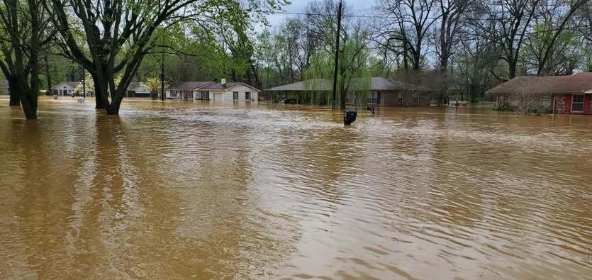
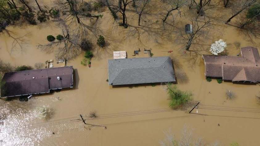
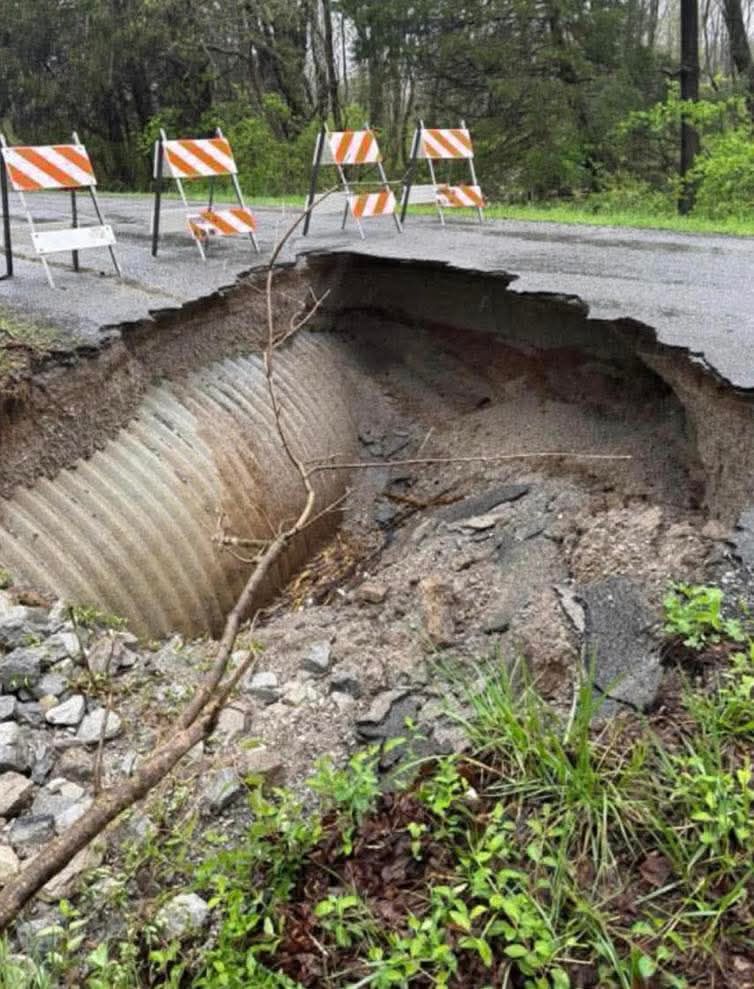
Photos
.jpg) |
 |
 |
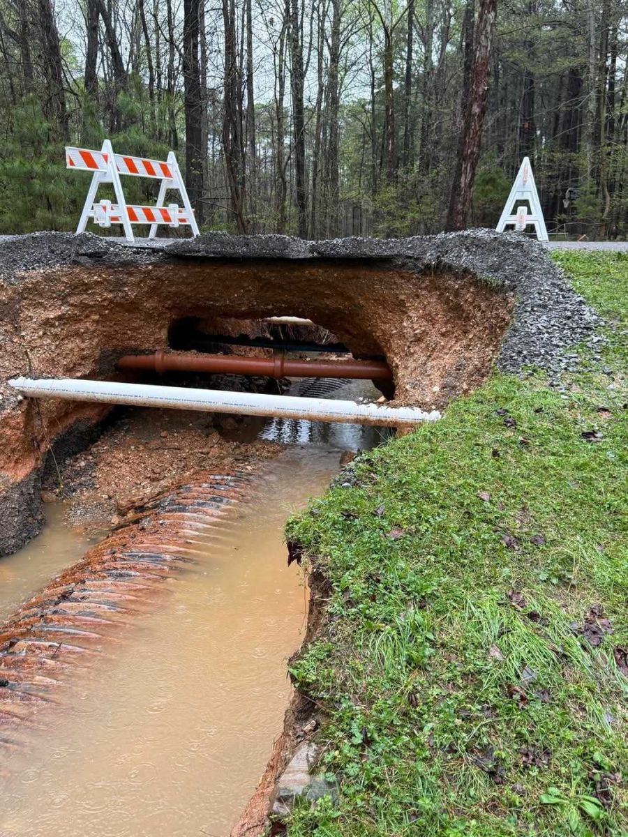 |
| Henderson, KY courtesy of Kenny Garrett | Hopkinsville, KY courtesy of Sarah Toby | Hopkinsville, KY courtesy of Sarah Toby | Road washed out at LBL Hillman Ferry Campground courtesy of Beau Dodson |
 |
.JPG) |
 |
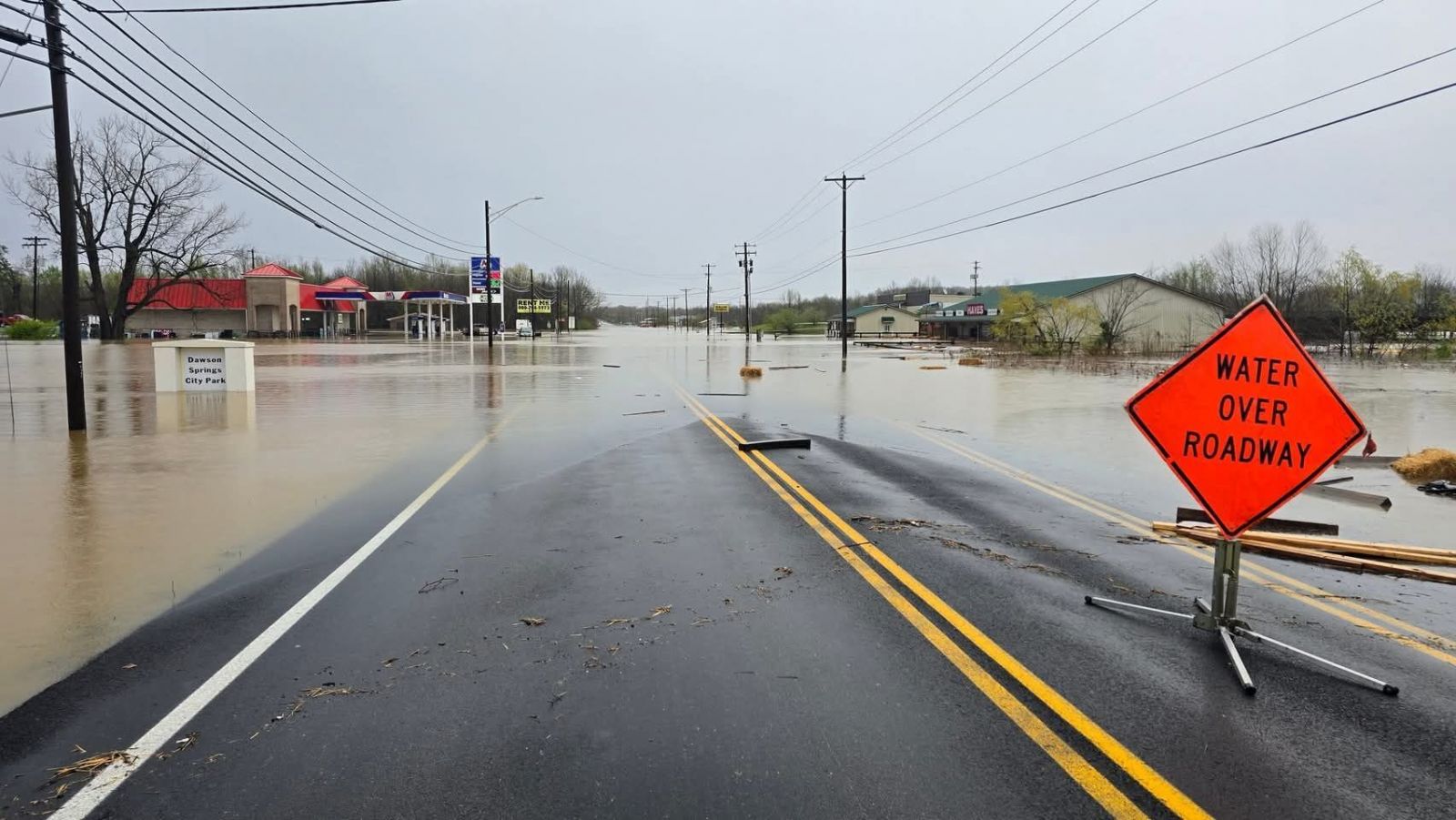 |
| Paducah, KY courtesy of Vick Patel | State Hwy 450 in Graves County, KY courtesy of Joseph Siedel | WFGS Radio in Murray, KY courtesy of Brian Harris | Dawson Springs, KY courtesy of Grant Keen |
 |
 |
 |
 |
| Franklin County, IL - Yellow Banks Road courtesy of Luke Saeger | Indian Point road washed out near Vienna, IL courtesy of Sherry Rigsby | Reese Creek northeast of Du Quoin via Raymond Clark | Norris City Road at County Road 1550 E in Hamilton County, IL courtesy of Westyn Welch |
.jpg) |
 |
 |
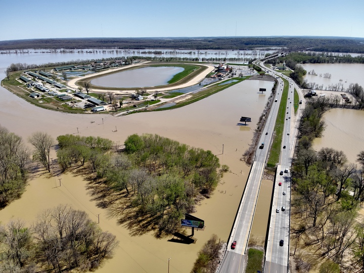 |
| Northeast of Pinckneyville, IL courtesy of Raymond Clark | Aerial view of Evansville, IN courtesy of Cliff Weaver | Aerial view of Evansville, IN courtesy of Cliff Weaver | Aerial view of Evansville, IN courtesy of Cliff Weaver |
Radar
Click here for a radar loop from this event (3 PM April 2nd through 3 AM April 6th).
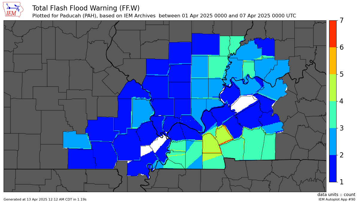 |
| Map of Flash Flood Warnings issued by county through the entire event |
Environment
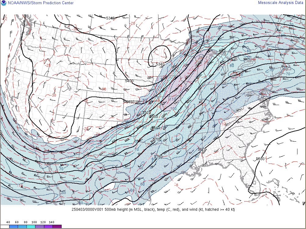
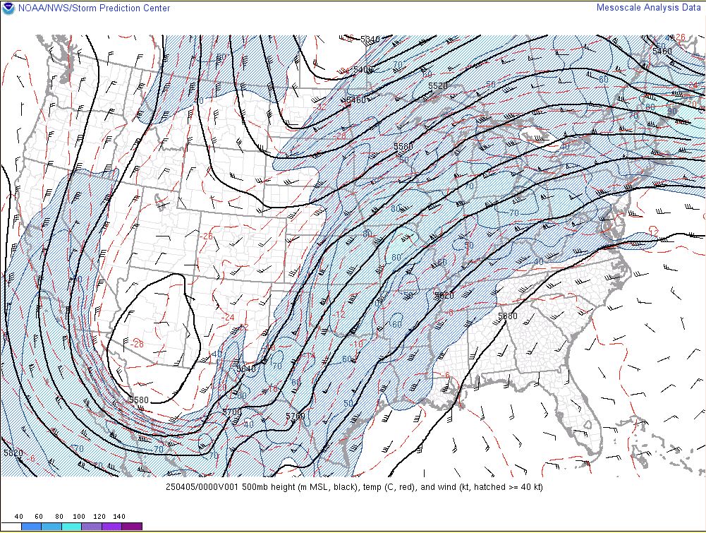
The mid to upper level pattern consisted of broad southwesterly flow across the Ohio and Tennessee Valley's in between a large scale trough across the western U.S. and ridging located along the southeast coast.
 |
 |
 |
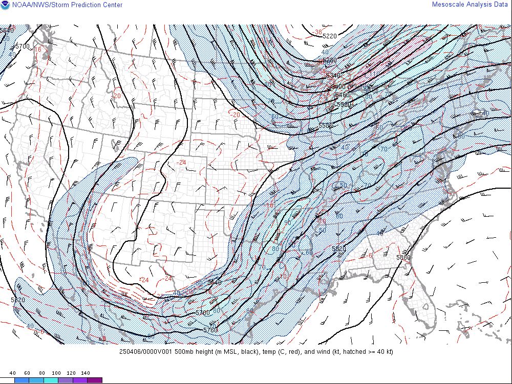 |
| 500mb chart - 7 PM April 2 | 500mb chart - 7 PM April 3 | 500mb chart - 7 PM April 4 | 500mb chart - 7 PM April 5 |
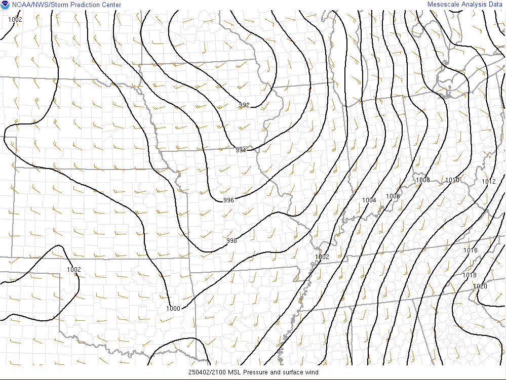
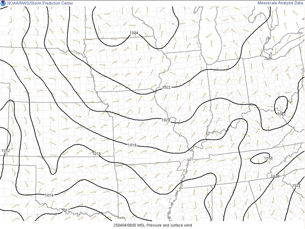
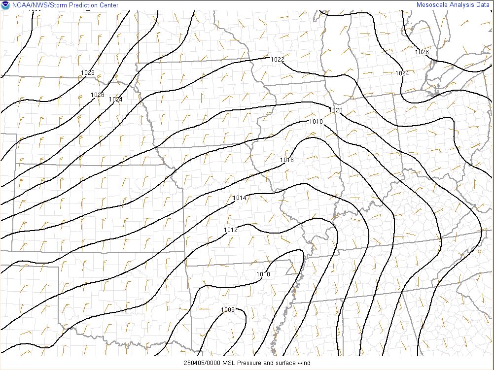
A cold front was located to our west on the afternoon of April 2nd. It would then make passage and become positioned to our south on the 3rd before lifting back north into western Kentucky and the Missouri bootheel on the 4th. The boundary would shift south of our area again on the 5th.
 |
 |
 |
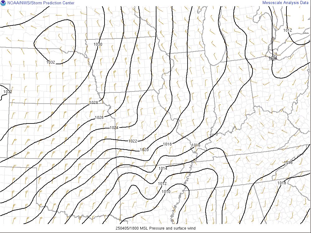 |
| Mean Sea Level Pressure - 4 PM April 2 | Mean Sea Level Pressure - 1 AM April 4 | Mean Sea Level Pressure - 7 PM April 4 | Mean Sea Level Pressure - 1 PM April 5 |
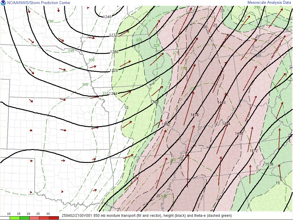
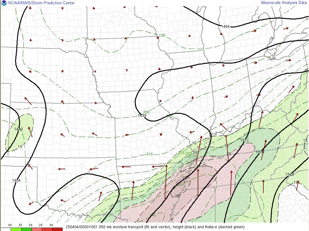
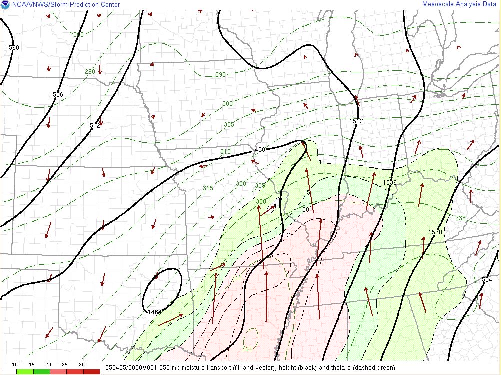
Low level moisture transport was quite anomalously through the 4 day period. The 850mb front remained draped over the region from April 3-5, even while the surface front largely remained south of the area during these periods.
 |
 |
 |
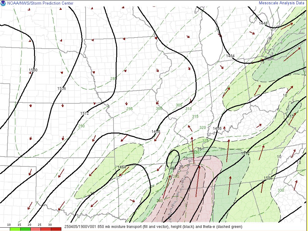 |
| 850mb Moisture Transport - 4 PM April 2 | 850mb Moisture Transport - 7 PM April 3 | 850mb Moisture Transport - 7 PM April 4 | 850mb Moisture Transport - 2 PM April 5 |
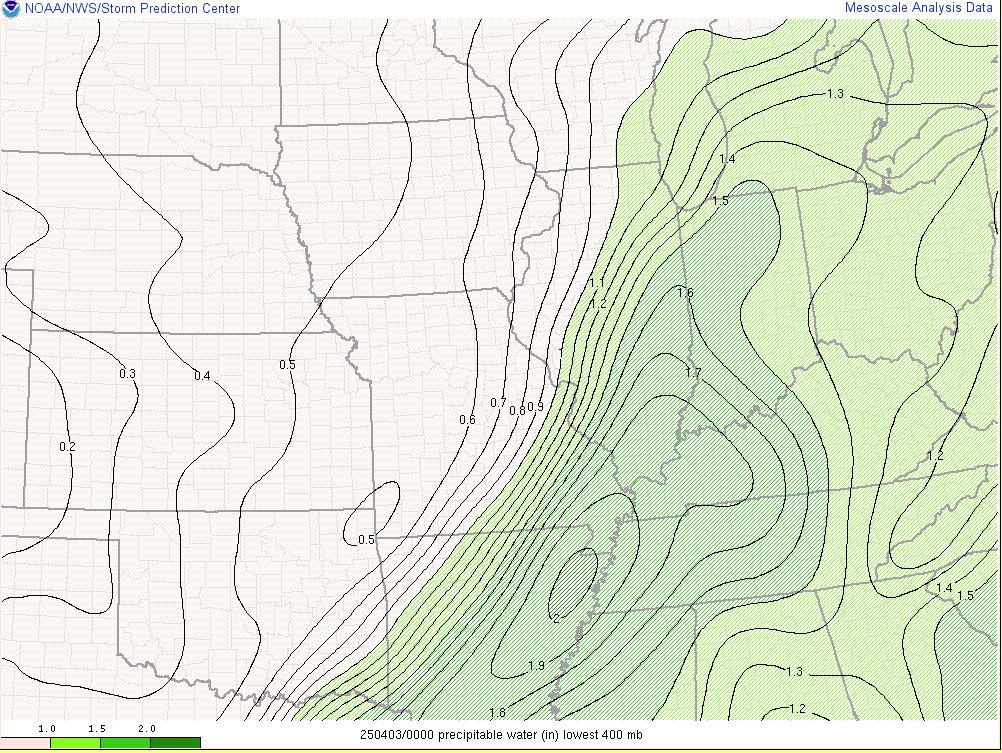
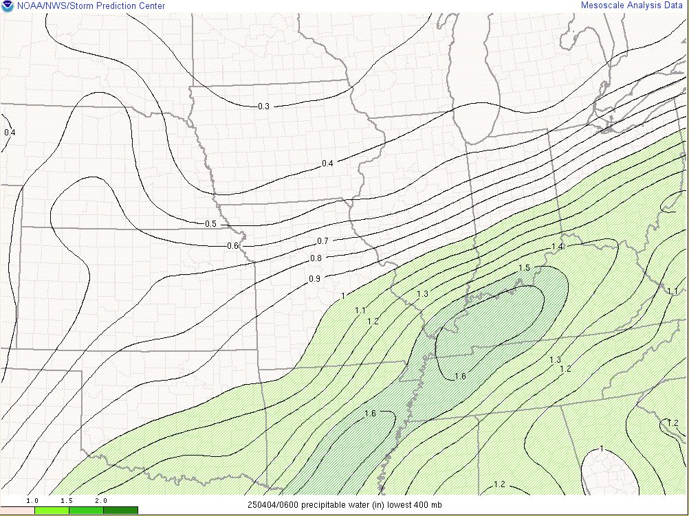
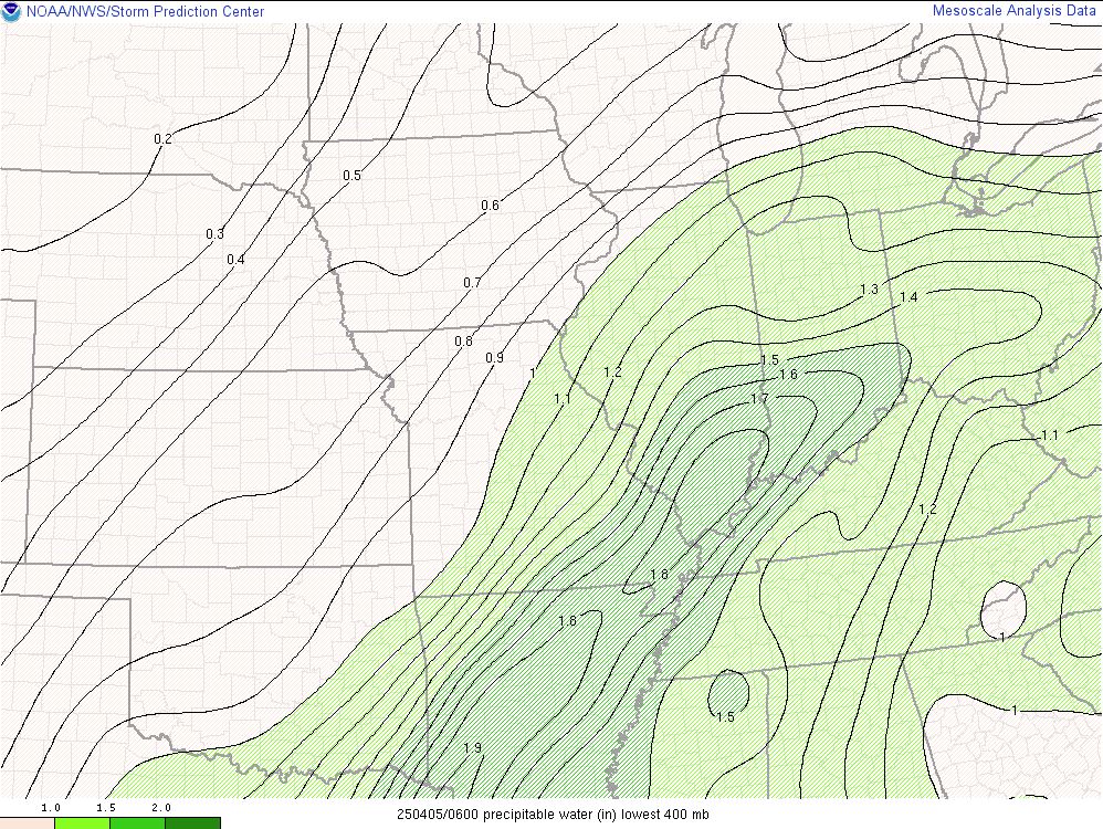
Precipitable water values ranged from 1.5 to 1.9" through the period, which was greater than the 99th percentile for this time of the year. This allowed thunderstorms to be very efficient rainfall producers as they continued to train across the same areas.
 |
 |
 |
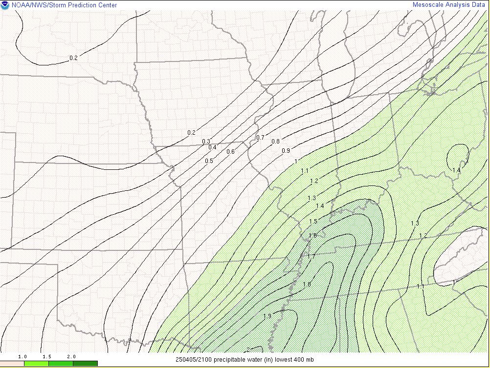 |
| Precipitable Water - 7 PM April 2 | Precipitable Water - 1 AM April 4 | Precipitable Water - 1 AM April 5 | Precipitable Water - 4 PM April 5 |
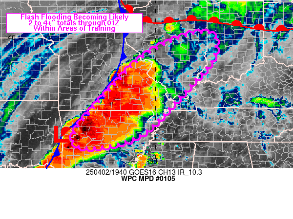
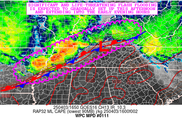
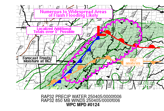
These are just a few of the numerous mesoscale precipitation discussions that were in effect across our region during this 4 day period.
 |
 |
 |
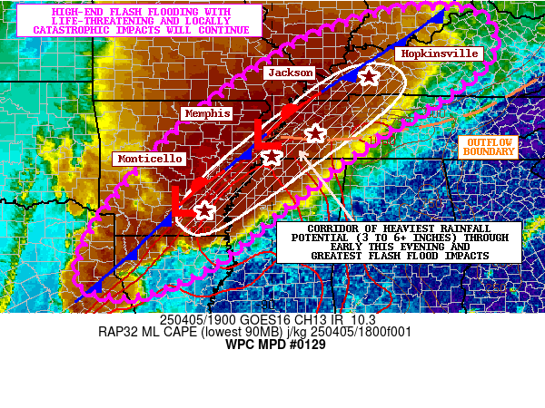 |
| WPC Mesoscale Precipitation Discussion on April 2 | WPC Mesoscale Precipitation Discussion on April 3 | WPC Mesoscale Precipitation Discussion on April 4 | WPC Mesoscale Precipitation Discussion on April 5 |
Service
Our office started messaging the heavy rain potential a week before the event unfolded. Forecast rainfall amounts were in the 6 to 10" range 3 days before the event began and then continued to trend upwards into the 10-15".
.PNG) |
.PNG) |
| Forecast Graphic issued by NWS Paducah on the morning of April 2nd | Forecast Graphic issued by NWS Paducah on the morning of March 30th |
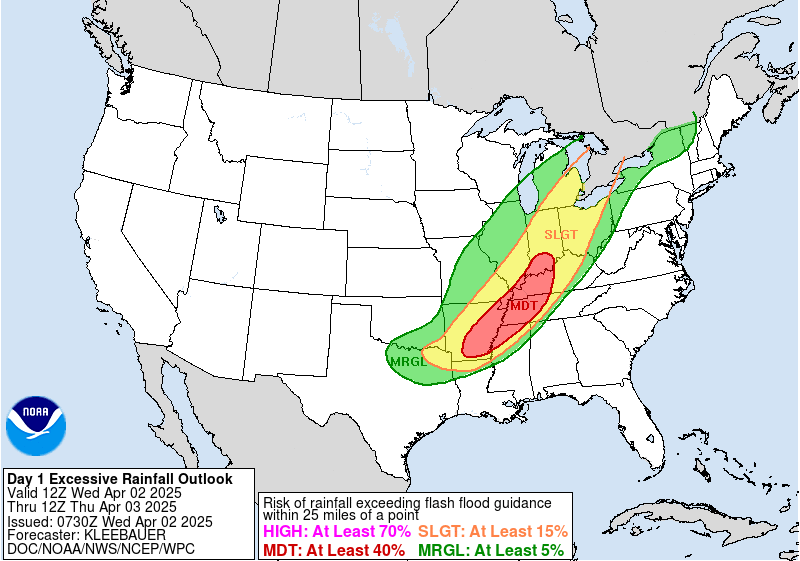
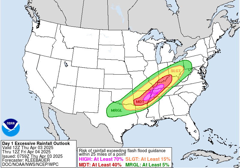
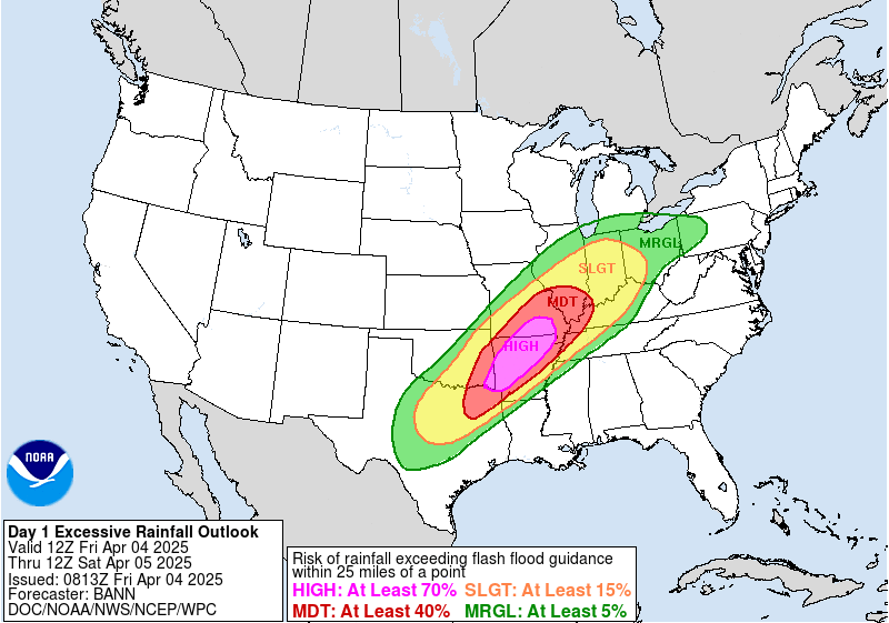
The Weather Prediction Center outlooked our region in a moderate risk for excessive rainfall on April 2nd. This was followed by 3 straight days where a high risk excessive rainfall outlook was in effect for some part of our forecast area from April 3-5.
 |
 |
 |
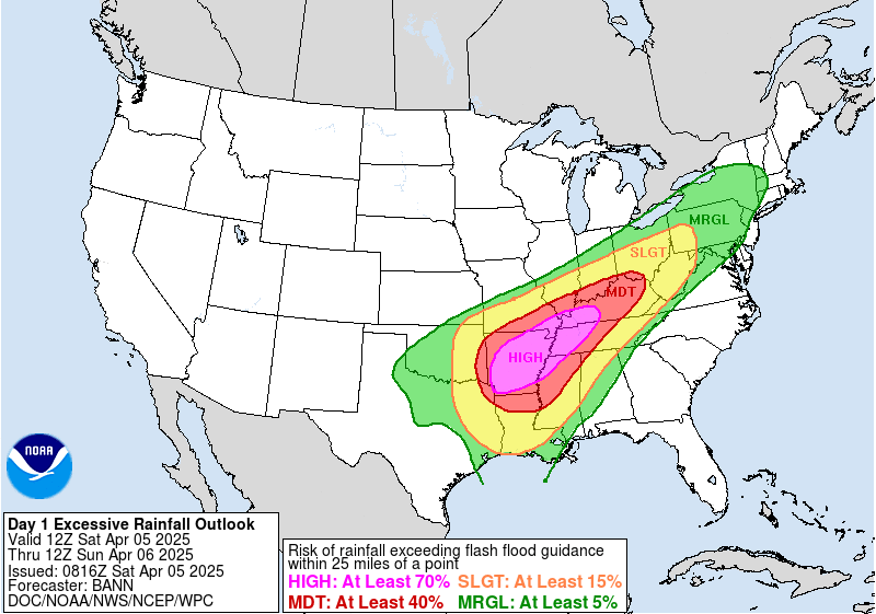 |
| WPC Day 1 Excessive Rainfall Outlook valid for April 2 | WPC Day 1 Excessive Rainfall Outlook valid for April 3 | WPC Day 1 Excessive Rainfall Outlook valid for April 4 | WPC Day 1 Excessive Rainfall Outlook valid for April 5 |
 |
Media use of NWS Web News Stories is encouraged! Please acknowledge the NWS as the source of any news information accessed from this site. |
|

