April 2024 Climate Review:
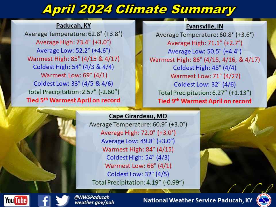
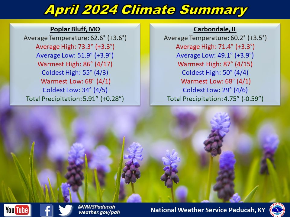
Temperatures were above normal by around 3.5 to 4 degrees. Paducah tied their 5th warmest April on record while Evansville observed their 9th warmest. The first two days of the month were well above normal with highs in the mid 70s to low 80s. Significantly cooler air moved across the region from the 3rd through the 5th with highs ranging from the mid 40s to upper 50s and lows falling into the 30s. An extended period of above normal temperatures was experienced from the 7th through the 18th. This included a 5 day period with highs exceeding 80 degrees from the 14th through 18th. This was rather rare to experience this level of warmth so early in the spring season. The last time Paducah observed 5 straight days of 80+ this early in the season was 2010, and it had only happened 4 other times on record before April 20th. For Evansville, it was only the 6th time they observed a stretch of 5 consecutive 80 degree days before April 20th. The warmest temperature in our area during this stretch was 88 degrees in Mount Vernon, IL and Perryville, MO on the 15th. A cooler period was observed from the 19th through the 22nd with highs in the upper 50s and 60s. The morning of the 22nd saw lows fall into the low to mid 30s, resulting in our last widespread frost of the spring season. Above normal temperatures returned from the 26th through 30th with highs back in the upper 70s to lower 80s. Paducah observed 10 days reaching 80 degrees, which was the most in April since 2001 (also 10 days). The record for April is 12 days set in 1957 and 1954. Meanwhile, Paducah had 10 days staying above 60 degrees for low temperatures which was tied for 2nd most on record for April (record is 11 days set in 1957).
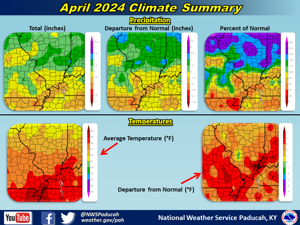
Precipitation was variable across the region. A decent portion of southeast Missouri into far southern Illinois and the Jackson Purchase area of west Kentucky finished drier than normal. Amounts ranged from 2.5-4.5” for many locations in this region. However, there were some locally higher amounts, particularly around the Poplar Bluff to Wappapello Lake areas which received 5 to 7”. Meanwhile, most of southwest Indiana, the Pennyrile region of west Kentucky, and areas of southern Illinois north of Route 13 observed a wetter than normal month. Most of this area observed 4.5-6.5”. The highest observed amount in our forecast area was 7.50” at a CoCoRaHS station 3.7 miles WNW of Poplar Bluff, MO. Moderate drought (D1) was in place across a good portion of the region throughout the month, but some improvement was noted by the end of the month across portions of southwest Indiana, northwest Kentucky, and southern Illinois north of Route 13.
There were two severe thunderstorm events that impacted the region in April. The most significant was on April 2nd when 19 tornadoes touched down, all within a 2 hour period between 4 and 6 AM. This was the most tornadoes in a single day in our forecast area since Halloween 2013 and only two shy of the record for an event set back on May 6, 2003 (21 tornadoes that day). Another system produced severe storms across our area on April 18th. Some wind damage and large hail occurred with this event, including 2” diameter hail in Johnson County Illinois.
The graphic below is an interpolated monthly rainfall map using actual observations. Please note that there are likely discrepancies in between observations, since the values are estimated based on nearest reports.
| April 2024 Review: Precipitation and Temperature Maps (Click on image to enlarge) |
 |
| Climate Maps are from the Northeast Regional Climate Center |


Monthly Climate Report: Paducah | Evansville | Cape Girardeau | Poplar Bluff | Carbondale