Overview
|
During the afternoon and evening hours of Sunday, March 30, 2025, supercell thunderstorms and lines and clusters of severe thunderstorms impacted the region. The storms produced at least one tornado, large hail, and damaging winds. |
Tornadoes
Select a tornado from the table to zoom into the track and view more information. The default table view is limited to 8 tracks, but can be scrolled by a mouse wheel or dynamically expanded. Additionally, the table can fill the entire window by clicking the small circular expanding arrow icon at the very top right of the table and returned to its original size by clicking the button again. The side information panel that opens over the map can be closed using the "X" on the upper right corner of the pop-up. Zoom into the map and click damage points to see detailed information and pictures from the surveys.
|
NOTE: times shown below are local to your device's time zone. |

The Enhanced Fujita (EF) Scale classifies tornadoes into the following categories:
| EF0 Weak 65-85 mph |
EF1 Moderate 86-110 mph |
EF2 Significant 111-135 mph |
EF3 Severe 136-165 mph |
EF4 Extreme 166-200 mph |
EF5 Catastrophic 200+ mph |
 |
|||||
| Tornadoes that fail to impact any ratable structures on the EF-Scale are rated EF-Unknown (EF-U) | |||||
Storm Reports
Preliminary Local Storm Report...Summary
National Weather Service Paducah KY
247 PM CDT Mon Mar 31 2025

..TIME...   ...EVENT...      ...CITY LOCATION...     ...LAT.LON...
..DATE...   ....MAG....      ..COUNTY LOCATION..ST.. ...SOURCE....
            ..REMARKS..

0315 PM     Hail             Dix                     38.44N 88.93W
03/30/2025  M0.88 Inch       Jefferson          IL   Amateur Radio


0347 PM     Hail             6 SW Campbell Hill      37.86N 89.63W
03/30/2025  E1.00 Inch       Jackson            IL   Fire Dept/Rescue


0349 PM     Hail             6 NW Pinckneyville      38.14N 89.47W
03/30/2025  E1.75 Inch       Perry              IL   Public


0400 PM     Hail             1 S Du Quoin            37.99N 89.24W
03/30/2025  E1.75 Inch       Perry              IL   Public

            Golf ball size hail lasted 8 minutes.

0400 PM     Hail             1 ENE Mount Vernon      38.32N 88.89W
03/30/2025  M0.70 Inch       Jefferson          IL   Trained Spotter


0400 PM     Hail             1 WSW Sesser            38.08N 89.07W
03/30/2025  E1.50 Inch       Franklin           IL   Public


0408 PM     Hail             1 SW Mount Vernon       38.30N 88.93W
03/30/2025  M1.00 Inch       Jefferson          IL   Public

            Hail fell for about 5 minutes and nearly
            covered the ground.

0409 PM     Hail             2 N Vergennes           37.92N 89.33W
03/30/2025  M1.00 Inch       Jackson            IL   Public


0415 PM     Hail             1 W Freemont            36.95N 91.18W
03/30/2025  E1.75 Inch       Carter             MO   Park/Forest Srvc

            Slightly larger than golf ball size hail.

0420 PM     Hail             1 NNW Du Quoin          38.01N 89.24W
03/30/2025  M1.25 Inch       Perry              IL   Emergency Mngr


0423 PM     Hail             4 NW Van Buren          37.04N 91.07W
03/30/2025  E1.00 Inch       Carter             MO   Fire Dept/Rescue

            Reported on M Hwy, 4 miles north of Van
            Buren.

0427 PM     Hail             Sesser                  38.09N 89.05W
03/30/2025  E1.25 Inch       Franklin           IL   Public

            Report from mPING: Half Dollar (1.25 in.).

0427 PM     Hail             Sesser                  38.09N 89.05W
03/30/2025  M0.25 Inch       Franklin           IL   Trained Spotter


0428 PM     Hail             Williamsville           36.98N 90.55W
03/30/2025  E1.75 Inch       Wayne              MO   Emergency Mngr


0433 PM     Hail             Sesser                  38.10N 89.05W
03/30/2025  E0.88 Inch       Franklin           IL   Emergency Mngr


0435 PM     Hail             Perryville              37.73N 89.87W
03/30/2025  M0.25 Inch       Perry              MO   Emergency Mngr


0444 PM     Hail             Longtown                37.67N 89.77W
03/30/2025  M1.75 Inch       Perry              MO   Public


0445 PM     Hail             Farrar                  37.71N 89.68W
03/30/2025  E1.50 Inch       Perry              MO   Fire Dept/Rescue


0449 PM     Hail             Longtown                37.67N 89.77W
03/30/2025  E1.00 Inch       Perry              MO   Emergency Mngr


0452 PM     Hail             Greenville              37.13N 90.45W
03/30/2025  M1.00 Inch       Wayne              MO   Law Enforcement


0452 PM     Hail             Greenville              37.13N 90.45W
03/30/2025  E1.75 Inch       Wayne              MO   Emergency Mngr


0501 PM     Tornado          1 WNW Naylor            36.58N 90.62W
03/30/2025                   Ripley             MO   Trained Spotter


0502 PM     Hail             Albion                  38.38N 88.06W
03/30/2025  M0.25 Inch       Edwards            IL   Trained Spotter


0508 PM     Hail             Zeigler                 37.90N 89.05W
03/30/2025  M0.88 Inch       Franklin           IL   Emergency Mngr


0509 PM     Hail             Royalton                37.88N 89.11W
03/30/2025  M0.50 Inch       Franklin           IL   Public

            Report from mPING: Half-inch (0.50 in.).

0511 PM     Hail             2 SSW Christopher       37.94N 89.06W
03/30/2025  E1.50 Inch       Franklin           IL   Emergency Mngr


0515 PM     Funnel Cloud     Neelyville              36.56N 90.51W
03/30/2025                   Butler             MO   Trained Spotter

            tornado was on the ground, lifted still
            seeing rotation.

0522 PM     Hail             1 SW Mount Carmel       38.40N 87.79W
03/30/2025  M0.25 Inch       Wabash             IL   Amateur Radio


0533 PM     Hail             Qulin                   36.60N 90.25W
03/30/2025  E1.00 Inch       Butler             MO   Amateur Radio


0538 PM     Hail             Hurst                   37.84N 89.14W
03/30/2025  E1.50 Inch       Williamson         IL   Emergency Mngr


0540 PM     Hail             1 SSE Hurst             37.82N 89.13W
03/30/2025  M0.88 Inch       Williamson         IL   Trained Spotter


0542 PM     Hail             Energy                  37.78N 89.02W
03/30/2025  M0.25 Inch       Williamson         IL   Trained Spotter


0548 PM     Tstm Wnd Gst     Bloomfield              36.89N 89.93W
03/30/2025  E60 MPH          Stoddard           MO   Trained Spotter

            Small branches broken.

0551 PM     Hail             Dexter                  36.80N 89.96W
03/30/2025  M1.00 Inch       Stoddard           MO   Emergency Mngr


0552 PM     Hail             2 NW Melody Hill        38.05N 87.53W
03/30/2025  E0.88 Inch       Vanderburgh        IN   Public


0556 PM     Hail             1 NNE Dexter            36.80N 89.96W
03/30/2025  M0.70 Inch       Stoddard           MO   Trained Spotter


0557 PM     Hail             5 NNE Melody Hill       38.09N 87.48W
03/30/2025  E1.00 Inch       Vanderburgh        IN   Public

            Pea to quarter size hail reported 2 miles
            northeast of the airport.

0558 PM     Hail             2 WSW Cynthiana         38.17N 87.74W
03/30/2025  M0.88 Inch       Posey              IN   Trained Spotter


0558 PM     Hail             1 SW Bernie             36.67N 89.98W
03/30/2025  E1.50 Inch       Stoddard           MO   Public

            Report from mPING: Ping Pong Ball (1.50
            in.).

0601 PM     Tstm Wnd Gst     2 W Scott City          37.23N 89.57W
03/30/2025  M58 MPH          Scott              MO   ASOS

            CGI airport gusted to 50 kt.

0603 PM     Hail             Bernie                  36.67N 89.97W
03/30/2025  M1.50 Inch       Stoddard           MO   Public

            Report from mPING: Ping Pong Ball (1.50
            in.).

0603 PM     Hail             3 W Dudley              36.79N 90.15W
03/30/2025  E1.50 Inch       Stoddard           MO   Public

            Report from mPING: Ping Pong Ball (1.50
            in.).

0605 PM     Tornado          1 S Thebes              37.20N 89.45W
03/30/2025                   Alexander          IL   NWS Storm Survey

            EF-1 tornado. 105 mph. 18.2 mile track.
            Numerous trees snapped, roof damage to homes
            and barns. Shrouded in 70-90 mph straight
            line winds to the south that eventually
            overtook the tornado and continued eastward
            into western Massac County.

0608 PM     Hail             Delta                   37.20N 89.74W
03/30/2025  M0.88 Inch       Cape Girardeau     MO   Trained Spotter


0615 PM     Tstm Wnd Gst     3 NNE Bandana           37.18N 88.92W
03/30/2025  M62 MPH          Ballard            KY   Amateur Radio


0630 PM     Tstm Wnd Dmg     5 W New Grand Chain     37.27N 89.10W
03/30/2025                   Pulaski            IL   Public

            Damage to high school roof.

0630 PM     Tstm Wnd Dmg     1 SW Olmsted            37.17N 89.10W
03/30/2025                   Pulaski            IL   Public

            Power poles snapped.

0641 PM     Hail             4 SW Carmi              38.05N 88.22W
03/30/2025  M0.25 Inch       White              IL   Trained Spotter


0645 PM     Hail             Haubstadt               38.20N 87.57W
03/30/2025  M0.25 Inch       Gibson             IN   Trained Spotter


0646 PM     Hail             1 E Haubstadt           38.20N 87.56W
03/30/2025  E0.50 Inch       Gibson             IN   Public

            Report from mPING: Half-inch (0.50 in.).

0657 PM     Hail             2 W Anniston            36.81N 89.36W
03/30/2025  E1.25 Inch       Mississippi        MO   Public

            Report from mPING: Half Dollar (1.25 in.).

0702 PM     Hail             Boonville               38.05N 87.27W
03/30/2025  E1.00 Inch       Warrick            IN   Emergency Mngr


0703 PM     Hail             Kevil                   37.09N 88.88W
03/30/2025  M0.25 Inch       Ballard            KY   Trained Spotter


0705 PM     Hail             4 WSW Chandler          38.01N 87.43W
03/30/2025  M0.25 Inch       Warrick            IN   Trained Spotter


0713 PM     Tstm Wnd Gst     6 NW Sturgis            37.62N 88.06W
03/30/2025  M58 MPH          Union              KY   Fire Dept/Rescue

            Measured at Henshaw Fire Dept.

0715 PM     Tstm Wnd Gst     5 S Wolf Island         36.67N 89.20W
03/30/2025  E58 MPH          Mississippi        MO   Mesonet


0721 PM     Hail             2 WSW Darmstadt         38.08N 87.61W
03/30/2025  E0.50 Inch       Vanderburgh        IN   Public


0725 PM     Hail             3 WNW Newburgh          37.96N 87.46W
03/30/2025  M0.25 Inch       Vanderburgh        IN   Trained Spotter


0725 PM     Tstm Wnd Gst     4 NE Marion             37.38N 88.04W
03/30/2025  M53 MPH          Crittenden         KY   Mesonet

            Mesonet station RPTN Marion KY 4 NE.

0730 PM     Tstm Wnd Gst     4 NE Marion             37.38N 88.03W
03/30/2025  M62 MPH          Crittenden         KY   Mesonet


0730 PM     Hail             Whitesville             37.69N 86.87W
03/30/2025  M1.00 Inch       Daviess            KY   Public

            Anywhere from pea to quarter size hail
            reported.

0732 PM     Hail             Clinton                 36.67N 89.00W
03/30/2025  M0.25 Inch       Hickman            KY   Emergency Mngr


0743 PM     Hail             1 E Conran              36.48N 89.63W
03/30/2025  E1.00 Inch       New Madrid         MO   Public

            Report from mPING: Quarter (1.00 in.).

0745 PM     Tstm Wnd Gst     5 NW Calhoun            37.59N 87.32W
03/30/2025  M56 MPH          McLean             KY   Mesonet


0750 PM     Hail             2 E Owensboro           37.75N 87.08W
03/30/2025  E0.50 Inch       Daviess            KY   Public

            Report from mPING: Half-inch (0.50 in.).

0751 PM     Hail             1 NE Santa Claus        38.13N 86.91W
03/30/2025  M0.25 Inch       Spencer            IN   Emergency Mngr


0755 PM     Hail             3 W Philpot             37.75N 87.05W
03/30/2025  M1.00 Inch       Daviess            KY   Public

            Report from mPING: Quarter (1.00 in.).

0756 PM     Hail             2 SSW Fancy Farm        36.73N 88.80W
03/30/2025  E1.75 Inch       Graves             KY   Emergency Mngr

            Corrects previous hail report from 2 SSW
            Fancy Farm.

0756 PM     Hail             3 N Fancy Farm          36.80N 88.79W
03/30/2025  E1.00 Inch       Graves             KY   Emergency Mngr


0802 PM     Tstm Wnd Gst     3 NE Earlington         37.30N 87.48W
03/30/2025  M41 MPH          Hopkins            KY   Public


0813 PM     Hail             Mayfield                36.74N 88.65W
03/30/2025  M1.00 Inch       Graves             KY   Public


0832 PM     Hail             3 NE Brewers            36.81N 88.41W
03/30/2025  M0.25 Inch       Marshall           KY   Public


0908 PM     Hail             1 SSE Gracey            36.87N 87.66W
03/30/2025  M1.00 Inch       Christian          KY   Broadcast Media

            1 inch hail reported south of Gracey.

0922 PM     Hail             6 NNW Allegre           37.01N 87.26W
03/30/2025  M1.00 Inch       Todd               KY   Broadcast Media

            1 inch hail reported NNW of Allegre, near
            the Christian and Todd County line.

0939 PM     Tstm Wnd Gst     Clifty                  36.99N 87.14W
03/30/2025  M65 MPH          Todd               KY   Public
Photos & Video
 |
 |
 |
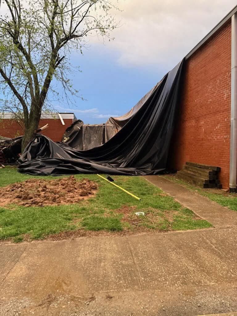 |
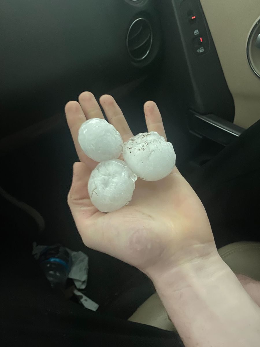
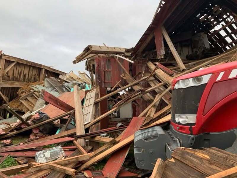
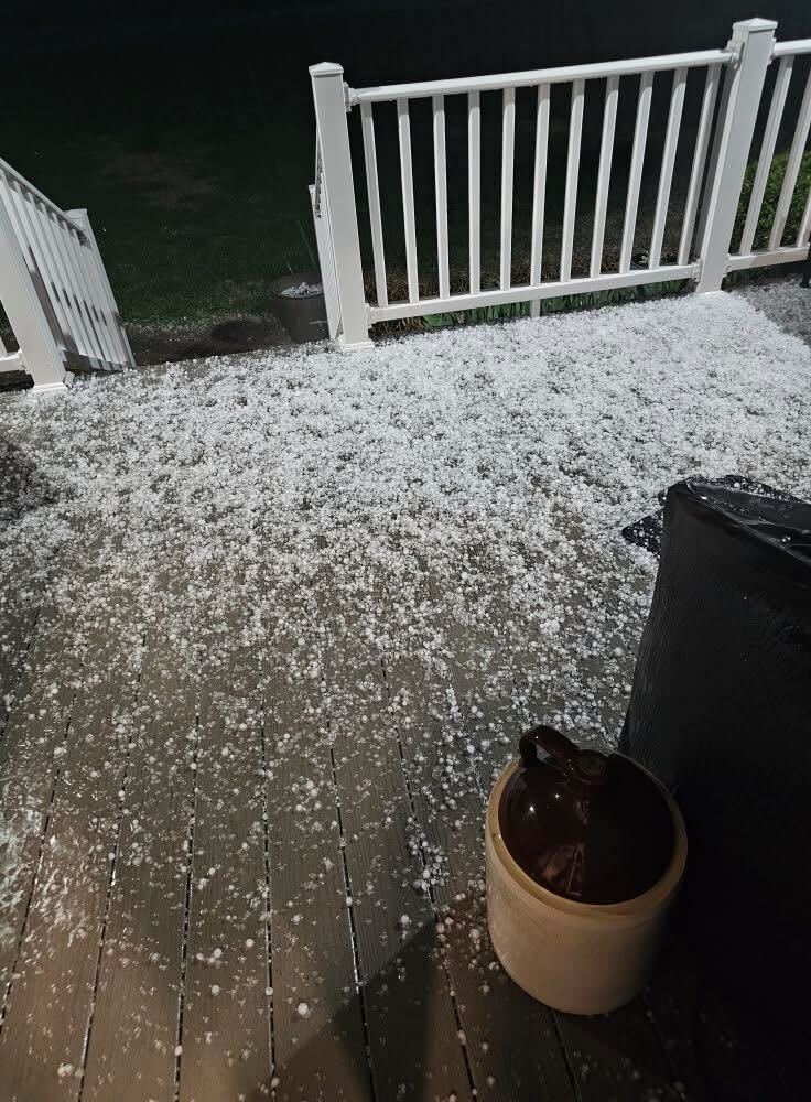
| Hail in Scott City, MO, via Beau Bishop/Stoddard County EMA | Damage to a barn in New Grand Chain, IL, via Christy Ulrigh | Hail in Columbus, KY, via Scott Smith/Hickman County EMA | Damage to Century School in Ullin, IL, via Nick Hausen |
Radar
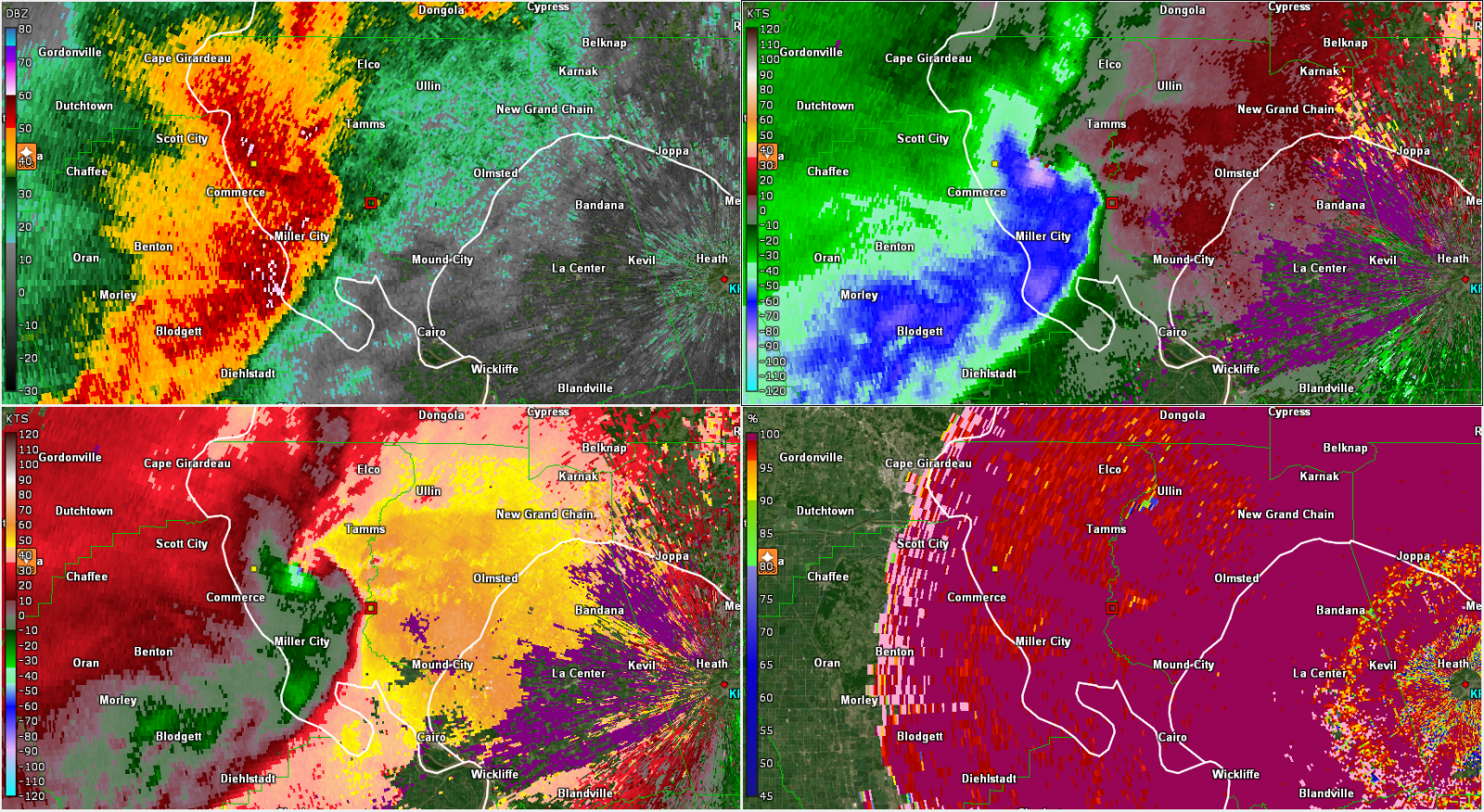 |
| KPAH reflectivity, base velocity, storm relative velocity, and correlation coefficient at 2312 UTC on March 30, 2025 |
 |
Media use of NWS Web News Stories is encouraged! Please acknowledge the NWS as the source of any news information accessed from this site. |
|

