Overview
Several clusters and lines of severe thunderstorms in addition to two EF-1 tornadoes swept through the region on the evening of Thursday, March 14, 2024. The thunderstorms developed in an unseasonably warm and humid environment. High temperatures soared into the middle and upper 70s with dew point temperatures climbing into the lower to middle 60s. The thunderstorms developed as a cold front approached the region from the west.
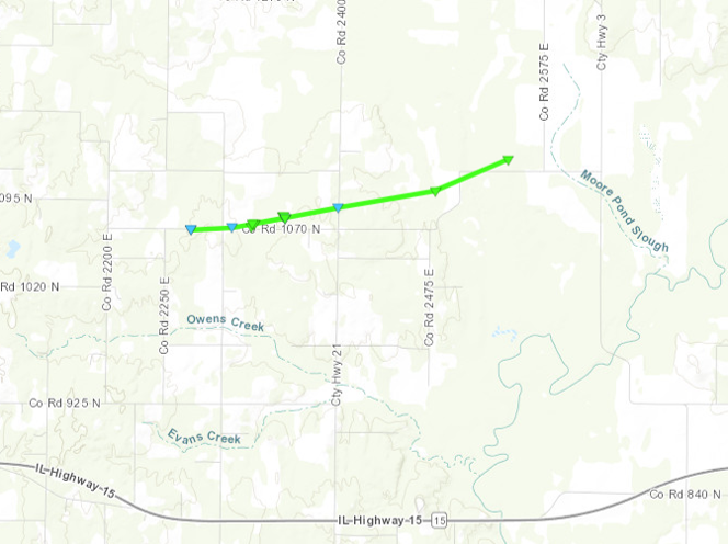
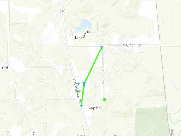
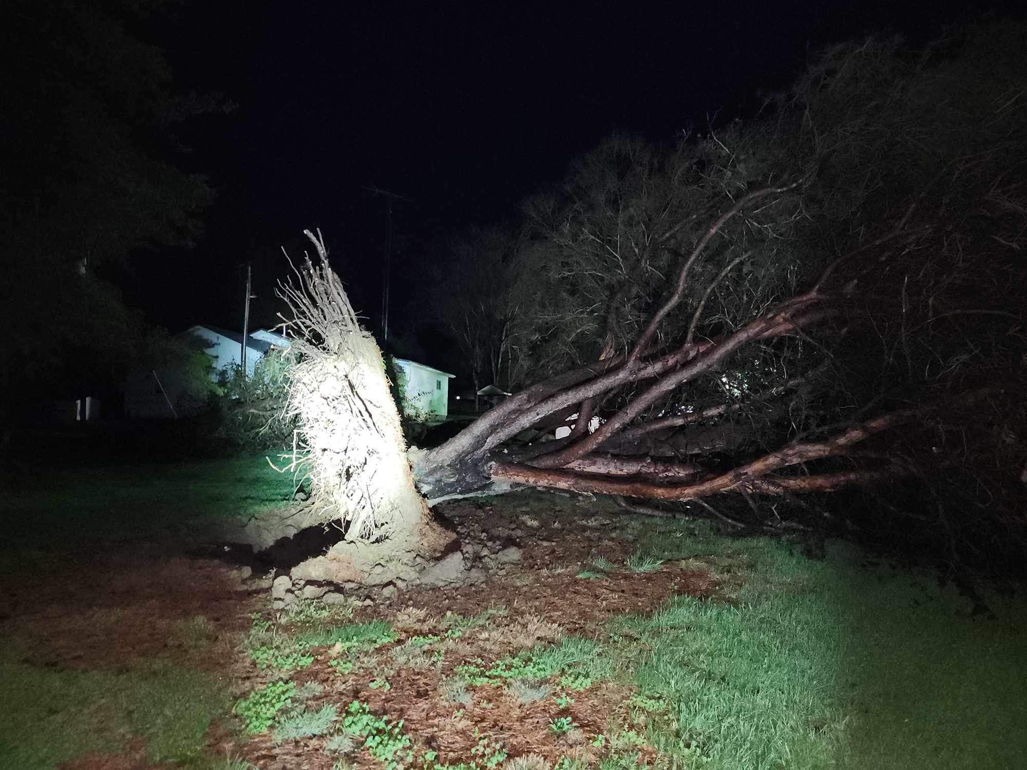
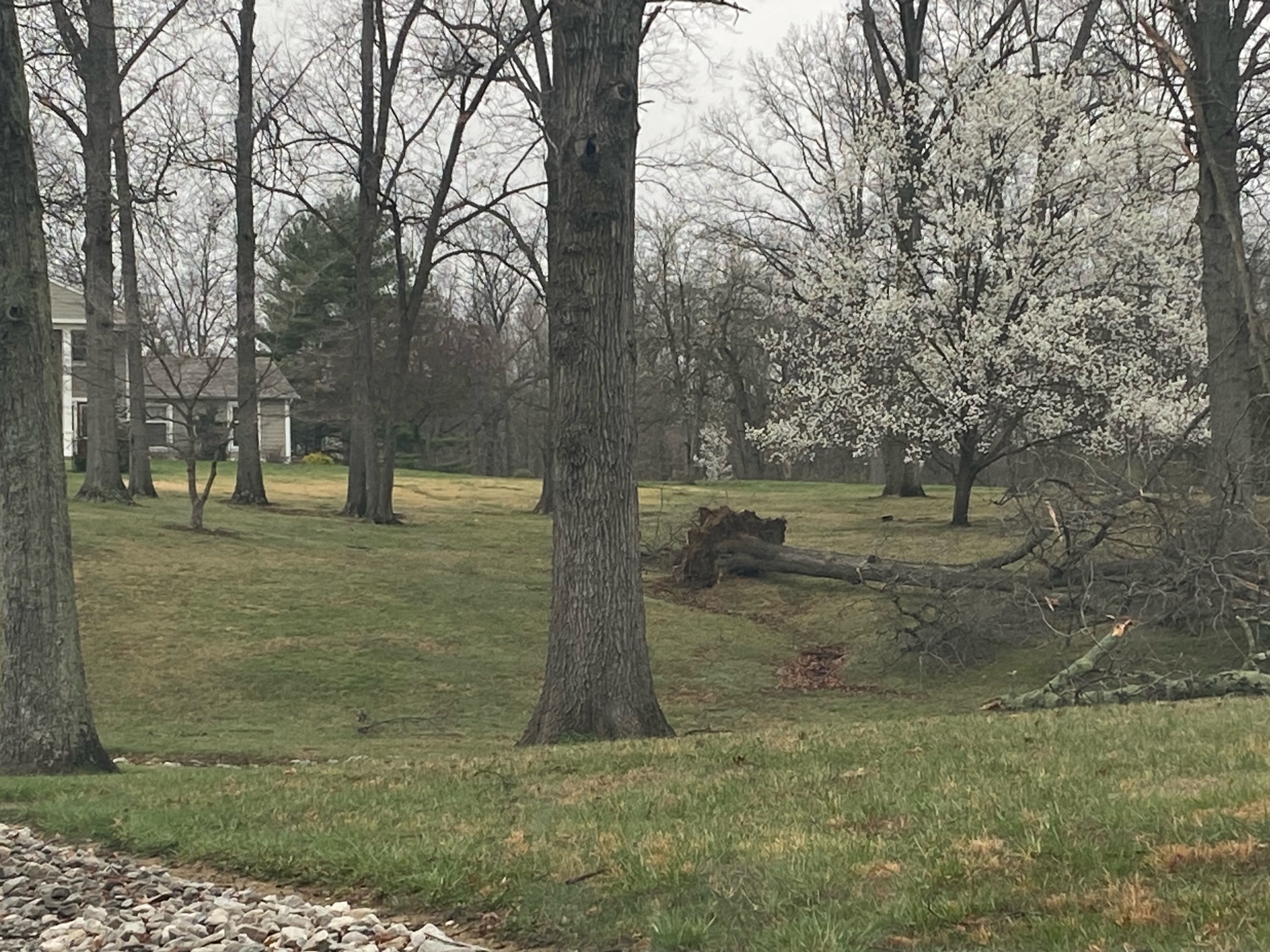
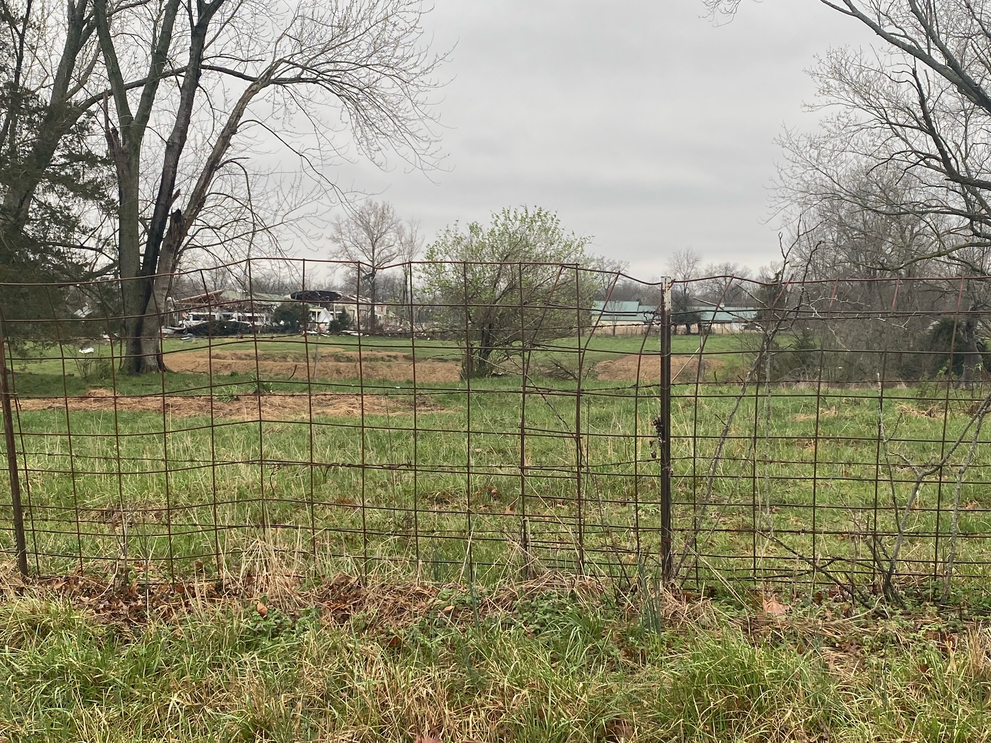
Widespread storm damage occurred along the Interstate 64 corridor across southern Illinois into southwest Indiana. The Southern Illinois communities of Mount Vernon and West Salem were particularly hard hit. On the northside of Mount Vernon, an EF-1 tornado inflicted significant roof and exterior wall damage to a bus depot and office A brick building on the downtown square in West Salem collapsed as it was buffeted by severe winds. Another EF-1 tornado struck a few miles northeast of Fairfield in rural Wayne County, severely damaging a mobile home and causing significant tree damage. Severe thunderstorm winds also caused tree, powerline, and barn damage in Ballard and McCracken Counties in western Kentucky.
As the storm moved through southeast Missouri, the Cape Girardeau Airport measured a 66 mph wind gust. A trained spotter also measured wind gusts of 60-75 mph near Hopkinsville, KY, as the severe storms moved eastward through the Kentucky Pennyrile.
Tornadoes:
|
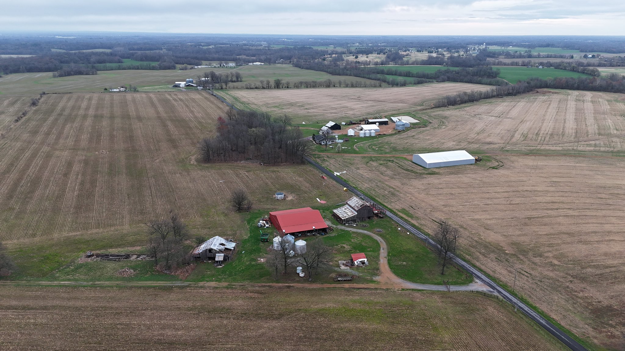
Tornado - 4 Miles NE of Fairfield, IL
|
||||||||||||||||
|
Tornado - 2 Miles N of Mount Vernon, IL
|
||||||||||||||||
The Enhanced Fujita (EF) Scale classifies tornadoes into the following categories:
| EF0 Weak 65-85 mph |
EF1 Moderate 86-110 mph |
EF2 Significant 111-135 mph |
EF3 Severe 136-165 mph |
EF4 Extreme 166-200 mph |
EF5 Catastrophic 200+ mph |
 |
|||||
Photos & Video
 |
 |
 |
 |
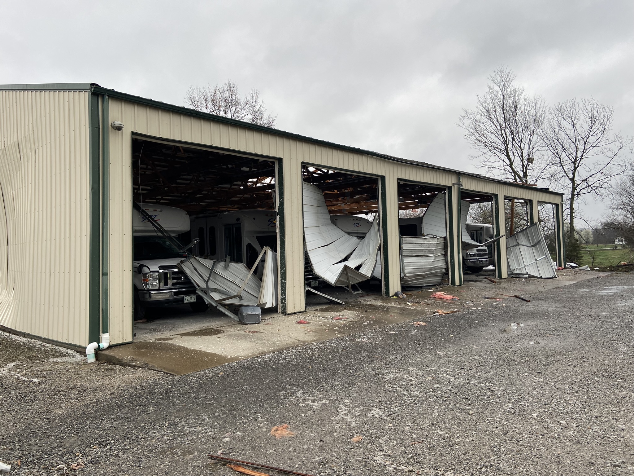
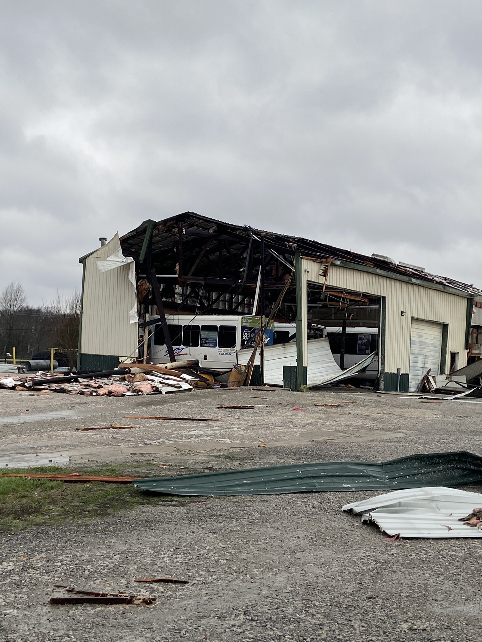
| Damage to South Central Transit in Mount Vernon, IL. (Keith Hertenstein/Jefferson County EMA) |
Damage to South Central Transit in Mount Vernon, IL. (Keith Hertenstein/Jefferson County EMA) |
Building damage in West Salem, IL. (Jessica Gwaltney) |
Barn and tree damage along Phelps Road in Ballard County, KY. (Dustin Bell) |
 |
 |
 |
 |
| Storm damage in Bluford, IL. (Beau Dodson) |
Storm damage in Bluford, IL. (Beau Dodson) |
Tree damage in Mount Vernon, IL. (Allan Ninnes/Saline County EMA) |
Damage in Mount Vernon, IL. (Allan Ninnes/Saline County EMA) |
Storm Reports
Preliminary Local Storm Report...Summary
National Weather Service Paducah KY
424 AM CDT Sat Mar 16 2024

..TIME...   ...EVENT...      ...CITY LOCATION...     ...LAT.LON...
..DATE...   ....MAG....      ..COUNTY LOCATION..ST.. ...SOURCE....
            ..REMARKS..

0652 PM     Tstm Wnd Gst     5 NNW Oxly              36.67N 90.71W
03/14/2024  M44 MPH          Ripley             MO   Public


0724 PM     Hail             Harviell                36.66N 90.47W
03/14/2024  M0.70 inch       Butler             MO   Broadcast Media


0730 PM     Hail             3 NW Woodlawn           38.36N 89.07W
03/14/2024  E1.00 inch       Jefferson          IL   Public

            Report from mPING: Quarter (1.00 in.).

0735 PM     Tstm Wnd Dmg     2 N Mount Vernon        38.35N 88.92W
03/14/2024                   Jefferson          IL   Amateur Radio

            Roof and structure damage to the South
            Central Transit bus building and office on
            Highway 37 just north of Mount Vernon. Time
            estimated from radar.

0735 PM     Tstm Wnd Dmg     Puxico                  36.95N 90.16W
03/14/2024                   Stoddard           MO   Emergency Mngr

            trees down reports of power outages.

0737 PM     Hail             1 SW Mount Vernon       38.30N 88.93W
03/14/2024  M1.00 inch       Jefferson          IL   Public


0739 PM     Tstm Wnd Gst     1 SW Mount Vernon       38.30N 88.93W
03/14/2024  M60 MPH          Jefferson          IL   Public


0743 PM     Hail             1 WSW Mount Vernon      38.31N 88.93W
03/14/2024  E0.50 inch       Jefferson          IL   Public

            Report from mPING: Half-inch (0.50 in.).

0746 PM     Tstm Wnd Dmg     3 SSE Dix               38.40N 88.92W
03/14/2024                   Jefferson          IL   Emergency Mngr

            power outages reported.

0750 PM     Tstm Wnd Dmg     3 NW Mount Vernon       38.34N 88.96W
03/14/2024                   Jefferson          IL   Emergency Mngr

            Trees down.

0751 PM     Hail             3 N Belle Rive          38.27N 88.74W
03/14/2024  E1.00 inch       Jefferson          IL   Public

            Report from mPING: Quarter (1.00 in.).

0754 PM     Tstm Wnd Gst     1 SE Cape Girardeau     37.30N 89.54W
03/14/2024  M66 MPH          Cape Girardeau     MO   ASOS

            Corrects previous tstm wnd gst report from 1
            SE Cape Girardeau.

0755 PM     Tstm Wnd Dmg     Vanduser                36.99N 89.69W
03/14/2024                   Scott              MO   Emergency Mngr

            Roof blown off house.

0758 PM     Hail             3 WNW Johnsonville      38.54N 88.59W
03/14/2024  E0.50 inch       Wayne              IL   Public

            Report from mPING: Half-inch (0.50 in.).

0800 PM     Tstm Wnd Dmg     2 N Belle Prairie City  38.26N 88.56W
03/14/2024                   Hamilton           IL   Emergency Mngr

            Multiple trees down on County Road 2400 N
            just west of County Road 800 E. Top of grain
            bin blown off into roadway.

0800 PM     Tstm Wnd Dmg     2 NNE Belle Prairie Cit 38.25N 88.54W
03/14/2024                   Hamilton           IL   Emergency Mngr

            Part of a roof blown off a machine shed in
            northern Hamilton County along State Highway
            242.

0800 PM     Tstm Wnd Dmg     3 S Blodgett            36.96N 89.53W
03/14/2024                   Scott              MO   Trained Spotter

            Large tree limbs down near Interstate 55
            north of Sikeston. Winds were estimated to
            be around 70 mph.

0807 PM     Tstm Wnd Dmg     2 NE Fairfield          38.40N 88.34W
03/14/2024                   Wayne              IL   Emergency Mngr

            Fairly widespread tree and powerline damage.
            Investigating one building with the roof
            removed in Wayne Co.

0807 PM     Tstm Wnd Dmg     Mount Vernon            38.32N 88.91W
03/14/2024                   Jefferson          IL   Emergency Mngr

            reports of thousands of power outages.

0829 PM     Tstm Wnd Dmg     West Salem              38.52N 88.01W
03/14/2024                   Edwards            IL   Trained Spotter

            Corrects previous tstm wnd dmg report from
            West Salem. Trained spotter shared a picture
            on Twitter of a brick building with a part
            of an exterior wall collapsed on the town
            square in West Salem. Time estimated by
            radar.

0834 PM     Tstm Wnd Dmg     3 W Paducah             37.08N 88.69W
03/14/2024                   McCracken          KY   NWS Storm Survey

            Corrects previous tstm wnd dmg report from 3
            W Paducah start time. Sporadic damage
            consistent with 70-75 mph wind gusts were
            found from near Cunningham, KY to the north
            side of Paducah near 8th Street. The damage
            was not oriented consistently with a
            convergent path and is likely a result of
            intense straight-line winds/downbursts along
            the squall line that was moving through.

0835 PM     Tstm Wnd Dmg     1 E Cunningham          36.91N 88.87W
03/14/2024                   Carlisle           KY   Emergency Mngr

            Power outages in the Cunningham area and
            northwest of Bardwell. Reports of trees down
            in both areas.

0835 PM     Tstm Wnd Dmg     5 ENE Bone Gap          38.47N 87.91W
03/14/2024                   Wabash             IL   Emergency Mngr

            Roof off the south side of a church at 400
            East and Wabash 17.

0836 PM     Tstm Wnd Dmg     6 NW Mount Carmel       38.47N 87.85W
03/14/2024                   Wabash             IL   Emergency Mngr

            Tops removed off of cedar trees near E 700
            Road and Wabash 17.

0838 PM     Tstm Wnd Dmg     3 NE Gage               37.02N 88.85W
03/14/2024                   Ballard            KY   Emergency Mngr

            Roof blown off a barn on Phelps Road in
            southeast Ballard County. Time estimated
            from radar.

0846 PM     Hail             Maunie                  38.04N 88.05W
03/14/2024  E0.75 inch       White              IL   Public

            Report from mPING: Dime size hail.

0846 PM     Hail             Carrier Mills           37.68N 88.63W
03/14/2024  E0.88 inch       Saline             IL   Law Enforcement


0853 PM     Tstm Wnd Dmg     2 NNE Paducah           37.10N 88.63W
03/14/2024                   McCracken          KY   Utility Company

            Metal roof removed from a building on North
            8th street in Paducah. Numerous powerlines
            downed in the area as well. Radar and damage
            consistent with a small area of enhanced
            straight line winds.

0855 PM     Tstm Wnd Dmg     2 NNW Hickory           36.84N 88.66W
03/14/2024                   Graves             KY   Law Enforcement

            Trees and power lines down across the
            county, including in the Folsomdale,
            Hickory, and Viola areas. Time estimated by
            radar.

0900 PM     Hail             Murray                  36.61N 88.32W
03/14/2024  M0.70 inch       Calloway           KY   Trained Spotter


0902 PM     Tstm Wnd Dmg     4 NNW Francisco         38.39N 87.46W
03/14/2024                   Gibson             IN   Public

            Report from mPING: 3-inch tree limbs broken;
            Power poles broken.

0904 PM     Tstm Wnd Dmg     2 NNW Paducah           37.10N 88.66W
03/14/2024                   McCracken          KY   Emergency Mngr

            Power lines down on home and trees down on
            Strathmoor Drive in Paducah. Also power
            outages reported on N 8th Street in Paducah
            and in the St. Johns area of McCracken
            County.

0914 PM     Tstm Wnd Dmg     Petersburg              38.49N 87.28W
03/14/2024                   Pike               IN   Trained Spotter

            Large tree limbs down with power outages.

0920 PM     Hail             Petersburg              38.49N 87.28W
03/14/2024  M1.00 inch       Pike               IN   Trained Spotter

            Pea to Quarter sized hail.

0925 PM     Tstm Wnd Dmg     2 SE Evansville         37.96N 87.51W
03/14/2024                   Vanderburgh        IN   Trained Spotter

            Trees down with estimated 60 to 65 mph wind
            gusts at storm onset. Time estimated from
            radar.

0933 PM     Tstm Wnd Gst     6 NW Sturgis            37.62N 88.06W
03/14/2024  M50 MPH          Union              KY   Emergency Mngr


0945 PM     Hail             1 NE Henderson          37.86N 87.57W
03/14/2024  E0.75 inch       Henderson          KY   Public

            Report from mPING: Dime size hail.

1028 PM     Tstm Wnd Gst     5 NE Herndon            36.76N 87.53W
03/14/2024  M75 MPH          Christian          KY   Trained Spotter

            Spotter measured 75 mph gust on I-24 at KY
            Hwy 107.

1030 PM     Tstm Wnd Dmg     2 W Whitesville         37.68N 86.91W
03/14/2024                   Daviess            KY   Emergency Mngr

            Tin roof removed off of a building in
            Whitesville. Only visible wind damage in the
            area. Some minor hail damage also reported
            in the area.


&&

$$
 |
Media use of NWS Web News Stories is encouraged! Please acknowledge the NWS as the source of any news information accessed from this site. |
|