
Scattered severe thunderstorms capable of large hail in excess of two inches, strong tornadoes, and damaging wind gusts are likely across parts of the Upper Mississippi Valley and Midwest this evening. Heavy to excessive rainfall may bring a flooding threat to portions of the Central Plains to the Midwest through Thursday. The heatwave in the Central U.S. will begin to push South and East Thursday Read More >
Overview
|
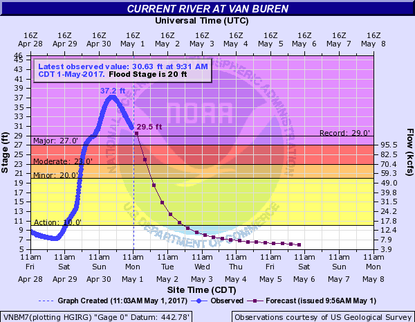
A strong storm system impacted the region over the last few days of April. Two rounds of significant rainfall affected our area. The 1st was from the evening hours of April 28th through the mid morning hours on April 29th. A lull in precipitation occurred during much of the daytime hours on the 29th, before the 2nd round of heavy rain moved in from the west during the evening hours, lasting through the morning hours on the 30th. The heaviest rainfall amounts were confined to portions of southeast Missouri into southern Illinois and southwest Indiana. A swath of 6 to 10 inches, with a few isolated higher amounts, was observed from Van Buren, MO to Carbondale and Carmi, IL and to Stendal, IN. Moderate to record river flooding occurred on over a dozen river locations due to the excessive rainfall in our area and points upstream in Missouri. The hardest hit river basins included the Current, Saint Francis, Black, Mississippi, Big Muddy, Patoka, and Little Wabash Rivers. Both Doniphan and Van Buren, MO saw record flooding on the Current River. These locations easily exceeded the high water levels experienced back in 2008, 1993, and 1904. The Saint Francis River at Patterson, MO also set a record crest, breaking the previous highest crest set back in 1982. |
|
Flooding
Hydrographs (Click on images to enlarge)
Record Flooding at these locations:
 |
 |
 |
| Current River - Van Buren, MO | Current River - Doniphan, MO | St. Francis River - Patterson, MO |
Major Flooding at these locations:
 |
 |
 |
 |
| Big Muddy River - Murphysboro, IL | Skillet Fork River - Wayne City, IL | St. Francis River - Fisk, MO | Patoka River - Princeton, IN |
 |
 |
 |
 |
| Mississippi River - Cape Girardeau, MO | Mississippi River - Thebes, IL | Little Wabash River - Carmi, IL | Black River - Poplar Bluff, MO |
Moderate Flooding at these locations:
 |
 |
 |
 |
| Big Muddy River - Plumfield, IL | Ohio River - Cairo, IL | Ohio River- Grand Chain Dam | Wabash River - New Harmony, IN |
**Please note that all of these crests are preliminary.
| Record Flooding | |||
| River | Location | Preliminary Crest | Old Record |
| Current | Van Buren, MO | 37.2 ft on April 30 | 29.0 ft on Mar 26, 1904 |
| Current | Doniphan, MO | 33.13 ft on May 1 | 26.8 ft on Mar 1, 1904 |
| St. Francis | Patterson, MO | 37.05 ft on April 30 | 35.77 ft on Dec 3, 1982 |
| Major Flooding | |||
| River | Location | Preliminary Crest | Record |
| Black | Poplar Bluff, MO | 21.96 ft on May 1 | 22.15 ft on Mar 20, 2008 |
| Skillet Fork | Wayne City, IL | 22.81 ft on May 1 | 26.68 ft on May 8, 1961 |
| Patoka | Princeton, IN | 24.29 ft on May 6 | 24.89 ft on May 4, 2011 |
| Little Wabash | Carmi, IL | 36.01 ft on May 7 | 38.44 ft on May 12, 1961 |
| Big Muddy | Murphysboro, IL | 38.56 ft on May 5 | 40.47 ft on May 3, 2011 |
| Mississippi | Cape Girardeau, MO | 45.99 ft on May 6 | 48.86 ft on Jan 1, 2016 |
| Mississippi | Thebes, IL | 43.18 ft on May 6 | 47.74 ft on Jan 2, 2016 |
| St. Francis | Fisk, MO | 26.13 ft on May 3 | 28 ft on Apr 18, 1927 |
Photos:
Click on images to enlarge:
 |
 |
 |
 |
| Doniphan, MO - 12PM on Apr 30 from Pamela Johnson Holt | Doniphan, MO - NWS Storm Survey | Doniphan, MO - NWS Storm Survey | Doniphan, MO - NWS Storm Survey |
 |
 |
 |
|
| Doniphan, MO - NWS Storm Survey | Poplar Bluff, MO - NWS Storm Survey | Poplar Bluff, MO - NWS Storm Survey |
 |
 |
 |
 |
| Poplar Bluff, MO - NWS Storm Survey | Poplar Bluff, MO - NWS Storm Survey | Wayne County, MO South of Greenville - NWS Storm Survey | Southern Wayne County, MO - NWS Storm Survey |
 |
 |
 |
 |
| East of Patterson, MO - NWS Storm Survey | Herrin, IL - Via Tony Laubach | Herrin, IL - Via Tony Laubach | Crocus Rd in Perry County, IL - Via WSIL |
 |
 |
 |
 |
| Chandler, IN flooding | Chandler, IN from Police Department | Old Cape Rd Jonesboro, IL - Via Robin Wilson | The Landing - Current River, MO via Facebook |
 |
 |
 |
 |
| Creek in Crossville, IL - Via Aaron Jones | Baseball Park near Route 13 in Harrisburg, IL - Via Twitter | Franklin County Illinois near Mitchell Lakes Area - Via Nick Hausen | Eldorado, IL looking north - Via Brad Reed |
 |
 |
 |
 |
| Black River below Clearwater Dam MO - NWS Storm Survey (May 16) | Black River below Clearwater Dam MO - NWS Storm Survey (May 16) | HH Highway near Clearwater Dam - NWS Storm Survey (May 16) | T Highway near Wappapello Dam - NWS Storm Survey (May 16) |
Storm Reports
..TIME...   ...EVENT...      ...CITY LOCATION...     ...LAT.LON...
..DATE...   ....MAG....      ..COUNTY LOCATION..ST.. ...SOURCE....
            ..REMARKS..

1200 PM     HEAVY RAIN       1 S MULKEYTOWN          37.96N 89.11W
04/29/2017  M2.38 INCH       FRANKLIN           IL   TRAINED SPOTTER

            SINCE MIDNIGHT.

1241 PM     HEAVY RAIN       HENDERSON               37.84N 87.58W
04/29/2017  M3.00 INCH       HENDERSON          KY   TRAINED SPOTTER

0258 PM     HEAVY RAIN       6 SW CAMPBELL HILL      37.87N 89.63W
04/29/2017  M4.20 INCH       JACKSON            IL   TRAINED SPOTTER

            FRIDAY NIGHT/EARLY SATURDAY STORM TOTAL.

0634 PM     HAIL             1 N MOUNT VERNON        38.33N 88.91W
04/29/2017  M0.75 INCH       JEFFERSON          IL   TRAINED SPOTTER

0647 PM     FLASH FLOOD      9 SW VAN BUREN          36.92N 91.13W
04/29/2017                   CARTER             MO   EMERGENCY MNGR

            FLOODING OF CREEKS REPORTED THROUGHOUT CARTER COUNTY.
            EMERGENCY MANAGEMENT IS EVACUATING RESIDENTS IN PART OF
            FREMONT.

0708 PM     HAIL             DE SOTO                 37.82N 89.23W
04/29/2017  M0.75 INCH       JACKSON            IL   TRAINED SPOTTER

            DIME SIZED HAIL

1200 AM     FLASH FLOOD      2 ENE LEORA             37.03N 89.95W
04/30/2017                   STODDARD           MO   DEPT OF HIGHWAYS

            COUNTY ROAD K CLOSED DUE TO WATER OVER ROADWAY BETWEEN
            COUNTY ROADS M AND BB.

1245 AM     HEAVY RAIN       7 NW POPLAR BLUFF       36.84N 90.50W
04/30/2017  M3.33 INCH       BUTLER             MO   TRAINED SPOTTER

            RAINFALL TOTAL IN PAST 5 HOURS. 0.57 INCHES IN LAST 50
            MINUTES.

0150 AM     FLASH FLOOD      5 ENE GRANDIN           36.86N 90.74W
04/30/2017                   CARTER             MO   DEPT OF HIGHWAYS

            HWY K IN SOUTHEAST PART OF COUNTY CLOSED NORTH OF HWY B
            DUE TO WATER OVER THE ROADWAY.

0200 AM     HEAVY RAIN       7 NW POPLAR BLUFF       36.84N 90.50W
04/30/2017  M4.72 INCH       BUTLER             MO   TRAINED SPOTTER

            RAINFALL TOTAL IN LAST 6 HOURS. 1.95 INCHES SINCE
            MIDNIGHT.

0215 AM     FLASH FLOOD      2 S MILL SPRING         37.04N 90.68W
04/30/2017                   WAYNE              MO   LAW ENFORCEMENT

            NUMEROUS ROADS IN THE COUNTY CLOSED DUE TO HIGH WATER
            INCLUDING HIGHWAY 49 SOUTH OF MILL SPRING. OTHER ROADS
            INCLUDE SECTIONS OF HIGHWAYS 143, 34, FF, KK, A, AND C.

0215 AM     FLASH FLOOD      2 W HARVIELL            36.66N 90.51W
04/30/2017                   BUTLER             MO   LAW ENFORCEMENT

            NUMEROUS COUNTY ROADS IN SOUTHERN PART OF COUNTY ARE
            IMPASSABLE DUE TO HIGH WATER INCLUDING A PORTION OF HWY
            160.

0225 AM     FLASH FLOOD      FAIRDEALING             36.66N 90.62W
04/30/2017                   RIPLEY             MO   LAW ENFORCEMENT

            HWY 160 EAST AT BUTLER COUNTY LINE AND ALSO IN
            FAIRDEALING HAS WATER OVER THE ROADWAY. COUNTY RD JJ HAS
            WATER OVER ROAD.

0252 AM     TORNADO          N MATTHEWS              36.76N 89.58W
04/30/2017                   NEW MADRID         MO   NWS STORM SURVEY

            EF-2 TORNADO. PEAK WINDS 125 MPH. PATH LENGTH 4 MILES.
            MAXIMUM PATH WIDTH 150 YARDS. TORNADO BEGAN 1/2 MILE
            NORTH OF MATTHEWS AND LIFTED 1 MILE SOUTH OF SIKESTON.
            ROOF REMOVED FROM ONE HOUSE AND PART OF ONE EXTERIOR WALL
            WAS BLOWN INWARD. ONE BARN LEVELED. TWO OTHER BARNS
            DAMAGED. SEVERAL TREES UPROOTED.

0253 AM     TSTM WND DMG     MATTHEWS                36.76N 89.58W
04/30/2017                   NEW MADRID         MO   EMERGENCY MNGR

            HOUSE DAMAGED JUST NORTH OF MATTHEWS AT THE INTERSECTION
            OF US 61 AND 80. NUMEROUS TREES DOWN AND UPROOTED. BARN
            DAMAGED. 3 OUTBUILDINGS DESTROYED. TIME ESTIMATED FROM
            RADAR.

0312 AM     TSTM WND DMG     MINER                   36.89N 89.53W
04/30/2017                   SCOTT              MO   LAW ENFORCEMENT

            TWO BUILDINGS DAMAGED IN TOWN. ONE WAS A METAL MODOT
            BUILDING AND ANOTHER WAS A BUSINESS WHICH WAS DAMAGED
            INCLUDING WINDOWS BEING BLOWN OUT. TIME OF OCCURRENCE WAS
            DETERMINED FROM SECURITY CAMERAS.

0320 AM     TSTM WND DMG     DIEHLSTADT              36.96N 89.43W
04/30/2017                   SCOTT              MO   TRAINED SPOTTER

            ONE SOLID OAK TREE TWO FEET IN DIAMETER WAS UPROOTED.
            PRIVACY FENCE DAMAGED. SOME SIDING RIPPED OFF A HOUSE.
            TIME ESTIMATED FROM RADAR.

0540 AM     HEAVY RAIN       7 NW POPLAR BLUFF       36.84N 90.50W
04/30/2017  E5.42 INCH       BUTLER             MO   TRAINED SPOTTER

            RAINFALL TOTAL IS FROM 8 PM SATURDAY THROUGH 540 AM
            SUNDAY

0605 AM     FLOOD            BROUGHTON               37.93N 88.46W
04/30/2017                   HAMILTON           IL   LAW ENFORCEMENT

            THE COMMUNITY REMAINS ISOLATED BY HIGH WATER. HIGHWAY 142
            IS CLOSED FROM SOUTH OF DALE TO THE SALINE COUNTY LINE.

0605 AM     FLOOD            4 N ELDORADO            37.87N 88.44W
04/30/2017                   SALINE             IL   LAW ENFORCEMENT

            HIGHWAY 142 IS CLOSED DUE TO HIGH WATER FROM STAR CHURCH
            NORTH TO THE HAMILTON COUNTY LINE.

0623 AM     FLOOD            WEST FRANKFORT          37.90N 88.93W
04/30/2017                   FRANKLIN           IL   LAW ENFORCEMENT

            FLOODING CONTINUES THROUGHOUT THE COMMUNITY AND ALONG
            HIGHWAY 37 NORTH AND SOUTH OF TOWN.

0628 AM     FLOOD            JOHNSTON CITY           37.82N 88.93W
04/30/2017                   WILLIAMSON         IL   LAW ENFORCEMENT

            HIGHWAY 37 IS CLOSED SOUTH OF TOWN. IN ADDITION A COUPLE
            OF COUNTY ROADS ARE STILL CLOSED DUE TO HIGH WATER.

0635 AM     FLOOD            DU QUOIN                38.00N 89.24W
04/30/2017                   PERRY              IL   LAW ENFORCEMENT

            EAST PARK STREET ROAD IS CLOSED FROM EAST OF DU QUOIN TO
            THE FRANKLIN COUNTY LINE. IN ADDITION A PORTION OF KIMMEL
            ROAD IS CLOSED JUST EAST OF HIGHWAY 51 APPROXIMATELY 3
            MILES NORTH OF DU QUOIN.

0700 AM     HEAVY RAIN       SIKESTON                36.88N 89.58W
04/30/2017  M2.40 INCH       SCOTT              MO   CO-OP OBSERVER

            SINCE 7 AM SATURDAY MORNING

0700 AM     HEAVY RAIN       JACKSON                 37.38N 89.65W
04/30/2017  M3.92 INCH       CAPE GIRARDEAU     MO   CO-OP OBSERVER

            SINCE 7 AM SATURDAY MORNING.

0730 AM     FLASH FLOOD      7 W POPLAR BLUFF        36.76N 90.53W
04/30/2017                   BUTLER             MO   LAW ENFORCEMENT

            KANE CREEK HAS FLOODED AND RESULTED IN SWIFTLY FLOWING
            WATER OVER A PORTION OF M HIGHWAY NEAR STRINGTOWN.

0900 AM     FLOOD            5 SW MOUNT VERNON       38.27N 88.98W
04/30/2017                   JEFFERSON          IL   TRAINED SPOTTER

            MOST CREEKS ARE FULL...SOME CREEKS OVERFLOWING. LOW AREAS
            ARE COMPLETELY FLOODED. TOWNSHIP ROADS IN LOW LYING AREAS
            ARE IMPASSABLE.

0900 AM     HEAVY RAIN       5 SW MOUNT VERNON       38.27N 88.98W
04/30/2017  M4.30 INCH       JEFFERSON          IL   TRAINED SPOTTER

            MEASURED 4.3 INCHES OF RAIN OVERNIGHT.

1038 AM     HEAVY RAIN       3 SE CLINTON            36.64N 88.96W
04/30/2017  M3.75 INCH       HICKMAN            KY   TRAINED SPOTTER

            OVERNIGHT TOTAL

1106 AM     HEAVY RAIN       2 W DEXTER              36.74N 88.33W
04/30/2017  M2.73 INCH       CALLOWAY           KY   COCORAHS

1106 AM     HEAVY RAIN       7 NW POPLAR BLUFF       36.84N 90.50W
04/30/2017  M5.45 INCH       BUTLER             MO   COCORAHS

            24 HOUR TOTAL ENDING AT 700 AM

1106 AM     HEAVY RAIN       ESE DE SOTO             37.82N 89.23W
04/30/2017  M3.32 INCH       JACKSON            IL   COCORAHS

            24 HOUR TOTAL ENDING AT 700 AM

1106 AM     HEAVY RAIN       3 S HERRIN              37.76N 89.03W
04/30/2017  M3.76 INCH       WILLIAMSON         IL   COCORAHS

            24 HOUR TOTAL ENDING AT 700 AM

1106 AM     HEAVY RAIN       2 ESE BUSH              37.83N 89.10W
04/30/2017  M3.10 INCH       WILLIAMSON         IL   COCORAHS

            24 HOUR TOTAL ENDING AT 700 AM

1106 AM     HEAVY RAIN       NNE JONESBORO           37.45N 89.27W
04/30/2017  M3.14 INCH       UNION              IL   COCORAHS

            24 HOUR TOTAL ENDING AT 700 AM

1106 AM     HEAVY RAIN       3 SE COULTERVILLE       38.15N 89.57W
04/30/2017  M3.00 INCH       PERRY              IL   COCORAHS

            24 HOUR TOTAL ENDING AT 700 AM

1106 AM     HEAVY RAIN       MOUNT VERNON            38.32N 88.91W
04/30/2017  M2.42 INCH       JEFFERSON          IL   COCORAHS

            24 HOUR TOTAL ENDING AT 700 AM

1106 AM     HEAVY RAIN       E SCOTT CITY            37.22N 89.53W
04/30/2017  M3.40 INCH       SCOTT              MO   COCORAHS

            24 HOUR TOTAL ENDING AT 700 AM

1120 AM     HEAVY RAIN       DIEHLSTADT              36.96N 89.43W
04/30/2017  M3.15 INCH       SCOTT              MO   TRAINED SPOTTER

            OVERNIGHT TOTAL

1140 AM     HEAVY RAIN       3 SW CARBONDALE         37.69N 89.26W
04/30/2017  M7.00 INCH       JACKSON            IL   TRAINED SPOTTER

            RAIN TOTAL SINCE FRIDAY. ALSO...3.1 INCHES SINCE NOON
            SATURDAY.

1140 AM     FLOOD            CROSSVILLE              38.16N 88.06W
04/30/2017                   WHITE              IL   TRAINED SPOTTER

            CREEK IN CROSSVILLE QUICKLY BEGINNING TO OVERTOP ITS
            BANKS.

1150 AM     FLASH FLOOD      5 SE CLINTON            36.61N 88.93W
04/30/2017                   HICKMAN            KY   EMERGENCY MNGR

            WATER COMPLETELY OVER U.S. HIGHWAY 51 BETWEEN HIGHWAY
            1529 AND SAWMILL ROAD...AND RISING.

1233 PM     HEAVY RAIN       FRUITLAND               37.45N 89.64W
04/30/2017  M4.75 INCH       CAPE GIRARDEAU     MO   AMATEUR RADIO

            OVERNIGHT TOTAL UP TO 1015 AM

1246 PM     FLOOD            2 E LA CENTER           37.07N 88.94W
04/30/2017                   BALLARD            KY   TRAINED SPOTTER

            4 INCHES OF RAIN ESTIMATED. PONDS, CREEKS OVERFLOWING.
            SOME ROADS UNDERWATER.

0206 PM     HEAVY RAIN       CAPE GIRARDEAU          37.31N 89.55W
04/30/2017  M3.50 INCH       CAPE GIRARDEAU     MO   TRAINED SPOTTER

            24 HOUR STORM TOTAL 3.5+ INCHES

0316 PM     HEAVY RAIN       MURRAY                  36.61N 88.32W
04/30/2017  M1.50 INCH       CALLOWAY           KY   TRAINED SPOTTER

            1.50 INCHES OF RAIN HAS FALLEN IN THE PAST 24 HOURS IN
            DOWNTOWN MURRAY.

0345 PM     FLASH FLOOD      DONIPHAN                36.62N 90.82W
04/30/2017                   RIPLEY             MO   LAW ENFORCEMENT

            RECEIVED CONFIRMATION FROM LOCAL SHERIFFS OFFICE THAT THE
            BRIDGE OVER THE CURRENT RIVER ON THE WEST SIDE OF
            DONIPHAN WHICH IS HWY 160/142 HAS BEEN SHUT DOWN.

0411 PM     HEAVY RAIN       3 S DIX                 38.40N 88.94W
04/30/2017  M4.80 INCH       JEFFERSON          IL   PUBLIC

            RAINFALL COLLECTED FROM FRIDAY AFTERNOON UNTIL PRESENT.

0415 PM     FLOOD            2 NNE EVANSVILLE        38.01N 87.53W
04/30/2017                   VANDERBURGH        IN   TRAINED SPOTTER

            PIGEON CREEK UNDER DIAMOND AVENUE IS OUT OF ITS
            BANKS...NOT OVER ROADWAY AT THIS TIME.

0520 PM     HEAVY RAIN       EVANSVILLE              37.98N 87.54W
04/30/2017  M3.10 INCH       VANDERBURGH        IN   TRAINED SPOTTER

            RAINFALL SINCE MIDNIGHT SATURDAY ON EAST SIDE OF
            EVANSVILLE NEAR PLAZA PARK MIDDLE SCHOOL.

0700 PM     HEAVY RAIN       FORT BRANCH             38.25N 87.57W
04/30/2017  M8.10 INCH       GIBSON             IN   TRAINED SPOTTER

            TWO DAY RAINFALL TOTAL.

0830 PM     HEAVY RAIN       RIDGWAY                 37.80N 88.26W
04/30/2017  M7.82 INCH       GALLATIN           IL   COCORAHS

            TOTAL SINCE FRIDAY MORNING.

1028 PM     HEAVY RAIN       CARTERVILLE             37.76N 89.08W
04/30/2017  M11.27 INCH      WILLIAMSON         IL   BROADCAST MEDIA

            3 DAY TOTAL MEASURED AT WSIL-TV STUDIO.

0930 PM     FLOOD            5 SE POPLAR BLUFF       36.71N 90.34W
05/01/2017                   BUTLER             MO   LAW ENFORCEMENT

            *** 1 FATAL *** VEHICLE...DRIVER SWEPT OFF ROAD ALONG
            HIGHWAY 53 AND COUNTY ROAD 618.

0600 AM     FLOOD            HARVIELL                36.66N 90.47W
05/02/2017                   BUTLER             MO   LAW ENFORCEMENT

            *** 1 FATAL *** VEHICLE...DRIVER SWEPT OFF ROAD ALONG
            COUNTY ROAD 153 JUST OUTSIDE OF HARVIELL.
Rainfall
Click on images to enlarge:
 |
 |
 |
 |
| April 28-30 Rainfall based on observations | April 27-May 3 Rainfall Totals | County Rainfall Records Established | FLASH soil moisture at 7AM from April 28-May 4. The soil can only hold so much water. Higher soil moisture allows for more runoff = higher potential for flash flooding |
| Rainfall Totals April 28-30, 2017 | |||
| Location | State | Station Type | Rainfall (inches) |
| Ellsinore | MO | Public | 12.25 |
| Old Appleton | MO | Public | 12.01 |
| Johnston City | IL | Public | 11.75 |
| Carterville (WSIL) | IL | Media | 11.27 |
| New Harmony | IN | Public | 11.00 |
| CARBONDALE SEWAGE PLT | IL | COOP | 10.37 |
| 1 SSW Spillertown | IL | CWOP | 10.36 |
| Ava | IL | Public | 10.20 |
| West Frankfort 0.3 WNW | IL | cocorahs | 10.16 |
| Stendal 0.1 SW | IN | cocorahs | 9.98 |
| Herrin 3.4 S | IL | cocorahs | 9.93 |
| Holland 6.3 NW | IN | cocorahs | 9.88 |
| Perryville 1.1 NE | MO | cocorahs | 9.87 |
| Ridgway | IL | CWOP | 9.75 |
| WILLIAMSVILLE | MO | COOP | 9.60 |
| Johnston City 3.9 ESE | IL | cocorahs | 9.45 |
| Marion 1 NNE | IL | cocorahs | 9.34 |
| Patterson | MO | River Gauge | 9.21 |
| PERRYVILLE WATR PLT | MO | COOP | 9.20 |
| Poseyville 2.8 NW | IN | cocorahs | 9.19 |
| Cobden 0.8 SSE | IL | cocorahs | 9.14 |
| COWI2 | IL | RAWS | 9.03 |
| Clear Water Lake | MO | River Gauge | 9.01 |
| Cape Girardeau 2N | MO | Public | 9.00 |
| Darmstadt | IN | Public | 9.00 |
| Van Buren | MO | River Gauge | 8.9 |
| Thompsonville | IL | Public | 8.8 |
| WEST FRANKFORT | IL | COOP | 8.75 |
| DuQuion | IL | Public | 8.75 |
| Bush 2 ESE | IL | cocorahs | 8.71 |
| STENDAL | IN | COOP | 8.63 |
| Goreville | IL | Public | 8.50 |
| Ridgway 0.3 ESE | IL | cocorahs | 8.45 |
| Carbondale 2.5 W | IL | cocorahs | 8.37 |
| Greenville 5.2 WNW | IN | cocorahs | 8.37 |
| CLEARWATER DAM | MO | COOP | 8.29 |
| Shawneetown | IL | Public | 8.26 |
| Mount Vernon | IN | Public | 8.20 |
| De Soto 0.3 ESE | IL | cocorahs | 8.16 |
| DeSoto | IL | Public | 8.16 |
| Wapappello Lake | MO | River Gauge | 8.1 |
| Mount Carmel | IL | Public | 8.00 |
| OakRidge | MO | Public | 8.00 |
| Murphysboro | IL | River Gauge | 7.96 |
| GRPM7 | MO | River Gauge | 7.94 |
| Jonesboro 0.3 NNE | IL | cocorahs | 7.83 |
| Jackson | MO | Public | 7.8 |
| PMRM7 | MO | RAWS | 7.79 |
| Marble Hill 0.4 NE | MO | cocorahs | 7.76 |
| MURPHYSBORO 2 SW | IL | COOP | 7.75 |
| 2 N Mount Vernon, IN | IN | Spotter | 7.72 |
| CARBONDALE SOUTHERN IL AP | IL | WBAN | 7.68 |
| Darmstadt | IN | Public | 7.50 |
| RRLM7 | MO | River Gauge | 7.48 |
| BGSM7 | MO | RAWS | 7.42 |
| HBBM7 | MO | River Gauge | 7.31 |
| LAKE WAPPAPELLO SP | MO | COOP | 7.25 |
| Harrisburg 4.6 NNE | IL | cocorahs | 7.20 |
| MT VERNON | IN | COOP | 7.16 |
| CARMI 2 | IL | COOP | 7.13 |
| CARI2 | IL | River Gauge | 7.12 |
| JACKSON | MO | COOP | 7.00 |
| Albion | IL | Public | 6.9 |
| MOCM7 | MO | River Gauge | 6.68 |
| Poplar Bluff 7.4 NW | MO | cocorahs | 6.54 |
| 3 S Poseyville | IN | CWOP | 6.51 |
| GDTI2 | IL | River Gauge | 6.28 |
| Cape G | MO | Public | 6.25 |
| Benton 1.3 NNE | IL | cocorahs | 6.16 |
| PINCKNEYVILLE 2 N | IL | COOP | 5.77 |
| 3 WSW Christopher | IL | CWOP | 5.69 |
| BNRI2 | IL | RAWS | 5.68 |
| CPGM7 | MO | River Gauge | 5.65 |
| WALTONVILLE | IL | COOP | 5.64 |
| Mount Vernon | IN | CWOP | 5.64 |
| EVANSVILLE FT COUR | IN | COOP | 5.63 |
| EVANSVILLE REGIONAL AP | IN | WBAN | 5.62 |
| WPPM7 | MO | River Gauge | 5.56 |
| Albion | IL | Public | 5.50 |
| Waltonville 3.4 WSW | IL | cocorahs | 5.46 |
| Scott City 0.9 E | MO | cocorahs | 5.37 |
| Mount Vernon | IL | Public | 5.35 |
 |
Media use of NWS Web News Stories is encouraged! Please acknowledge the NWS as the source of any news information accessed from this site. |
|

