
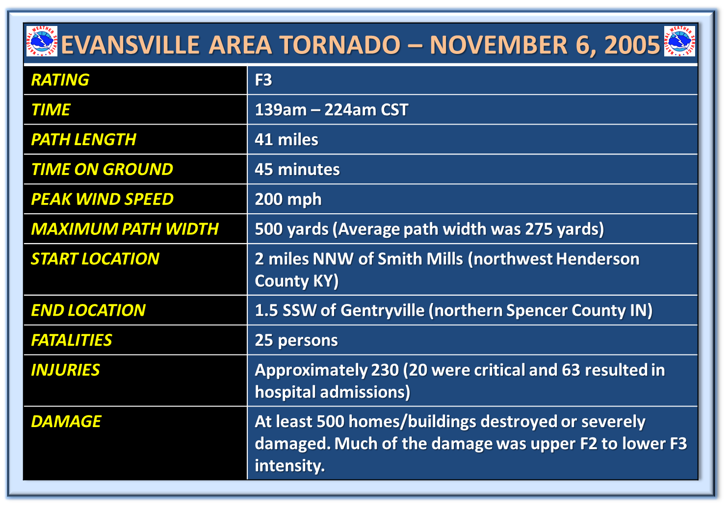
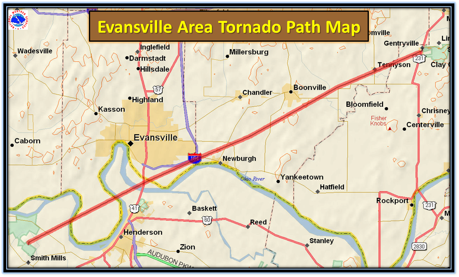
During the early morning hours on November 6 2005, a deadly tornado touched down about 25 miles southwest of Evansville Indiana, near the small community of Smith Mills KY in northwest Henderson county KY. The tornado rapidly became a violent F3 tornado and with a rapid rate of speed, it crossed the Ohio River three times before trekking across three southwest Indiana counties, leaving a 41 mile path of destruction and killing 25 people. This was the deadliest tornado to strike Indiana since 1974 and, at that time, it was the deadliest tornado since 1999 nationwide. We will provide a comprehensive look at this event to commemorate the lives lost on this day.
Below are quick links to take you to specific areas of this webpage:
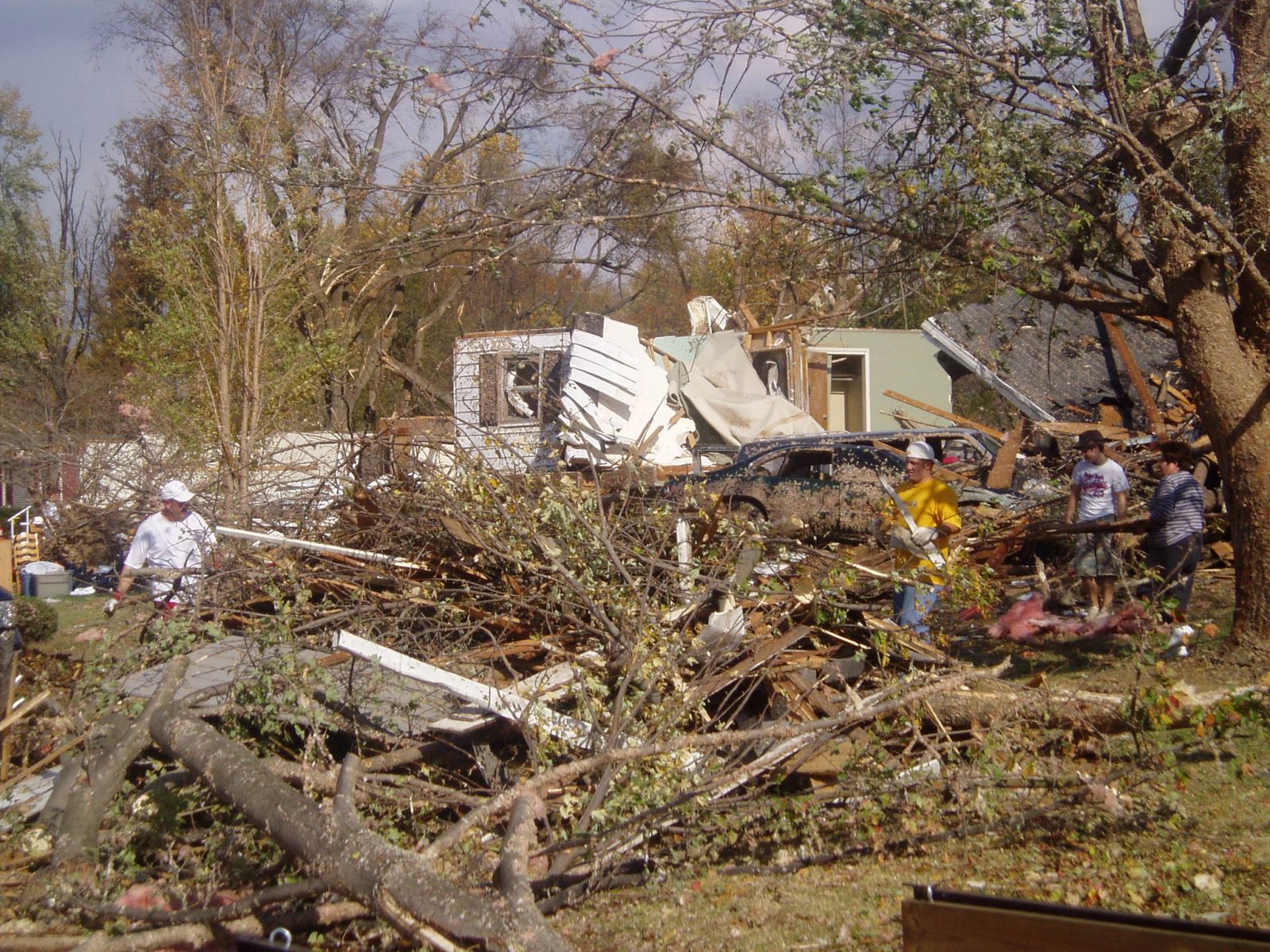
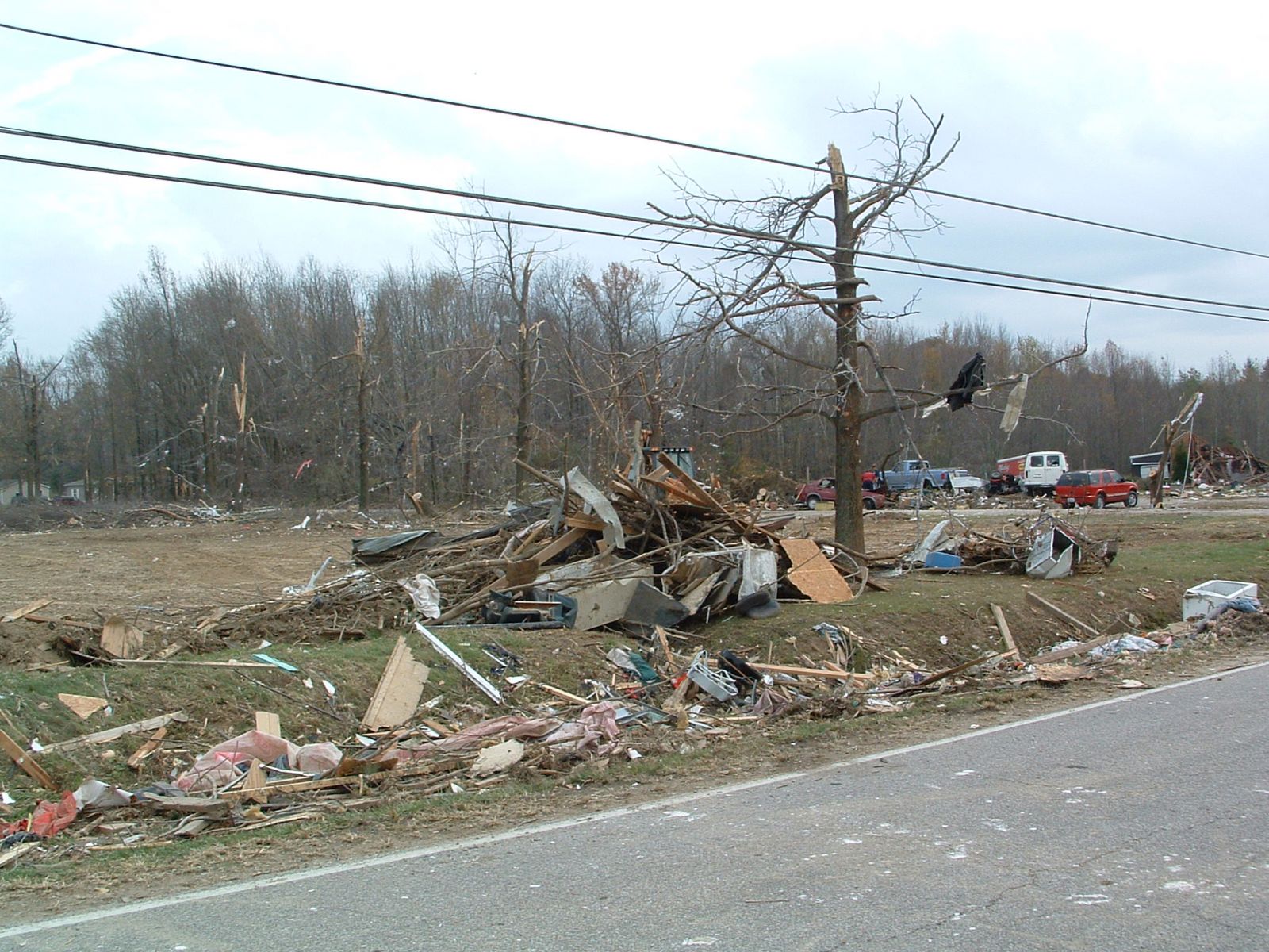
DAMAGE PHOTOS:
PENINSULA OF VANDERBURGH COUNTY

This is the only known photo of the tornado. Taken from the webcam at Deaconess Hospital, Evansville as lightning lit up the tornado.
On the morning of November 5 2005, folks across the Tri State Region woke up a rather warm, humid morning with temperatures in the upper 50s to lower 60s along with a light southerly breeze. Thunderstorms were in the forecast for the day with the chances becoming more numerous through the night as a cold front was forecast to move eastward across the region. Severe weather was a possibility and at this point in the day, the thinking was that storms could produce some hail and damaging winds based on the strong winds throughout the atmosphere.
By late afternoon, temperatures had surged into the lower 70s with a strong south wind. In fact, the high in Evansville, IN on November 5 was 77 degrees, which was one degree shy of the record of 78, set back in 1975. By 600pm, a broken line of storms had formed in Missouri along the cold front. The threat for severe weather was increasing, with damaging winds and hail being the main threats expected, along with a few isolated tornadoes. The broken line of storms over Missouri was expected to congeal and strengthen into a fast moving squall line ahead of the cold front. This strong to severe line of storms would move into southern IL, western KY and southwest IN during the evening and into the overnight hours. Below is a radar image at around 6pm and a weather map at that same time, showing where the low pressure system and accompanying cold front were located: (Click for larger view).

At around 900pm, the Storm Prediction Center highlighted the fact that this line was going to be moving into southeast MO, southern IL and west KY by late evening and by 930pm, a severe thunderstorm watch was issued for part of our area. By 956pm, our office began issuing warnings for parts of southeast MO as the line of potent storms began moving into our county warning area (CWA). An F2 tornado touched down in Ripley County Missouri at 1039pm and was on the ground for 7.4 miles. This tornado entered Ripley county from Oregon County. A home a barn received extensive damage in the community of Tucker, which is where the tornado reached its peak intensity and width. Peak winds were estimated near 120 mph with an average path width of 150 yards.


It would take until after 100am before the line of storms made their way across the Wabash River. The storms never really congealed into a solid line as expected. Instead, a broken line of embedded supercell storms were trekking east toward the Tri State Region. The NWS in Paducah was already closely watching a storm of concern over Union County IL just shortly after midnight.

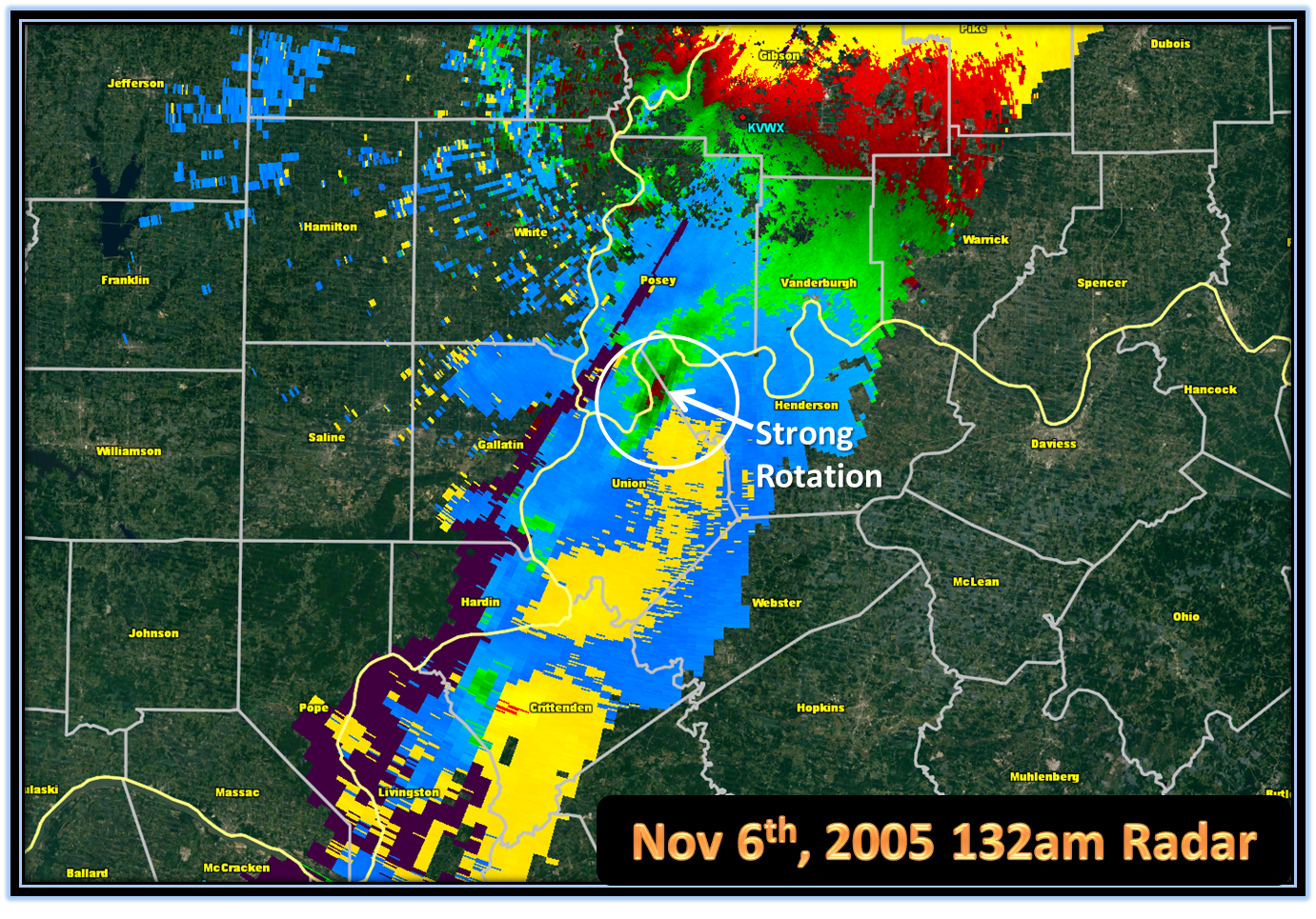
The storm in Union County IL continued to move northeast across far southern IL and slowly strengthen. The circulation really became strong as it was crossing the Wabash River. By 132 am, a tornado warning was issued for parts of Henderson County KY and Posey County IN until 200 am:
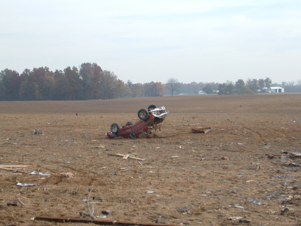
At 139 am, the tornado touched down in northwest Henderson County about 2 miles north northwest of Smith Mills KY and moved rapidly east-northeast across Ohio River bottomland. This fertile bottomland, used primarily for farming, was sparsely populated. Once the tornado began, it become violent very quickly and a well-defined swath of snapped and uprooted trees was visible by air. An isolated farm house a few miles northeast of Smith Mills was destroyed. A pickup truck at the house was thrown into a field and destroyed.

Damage photos from near Smith Mills, KY:

At 147 am, the NWS issued a tornado warning for southern Vanderburgh County, IN until 215am. About 5 minutes after that warning was issued, the NWS issued a statement that mentioned the city of Evansville was in the path of this tornado.
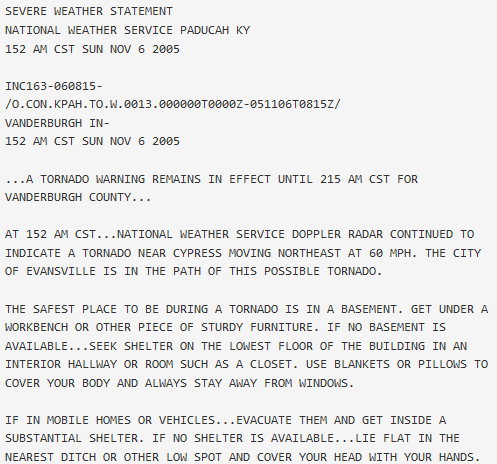
The tornado crossed into Vanderburgh County, Indiana from Henderson County, KY at a peninsula formed by the Ohio River just west of Henderson, KY. This peninsula is Ohio River bottomland primarily used for farming. From the air, scour marks were clearly visible on farmland. There were very few structures impacted in this small part of the county. A two-story house built in 1875, sustained major roof damage. Tree branches were embedded into the house. One farm equipment shed was demolished and another sustained major damage. A 10,000-pound truck was flipped over. Heavy farm equipment was moved several feet.

Damage pictures from the central peninsula of Vanderburgh County, IN:


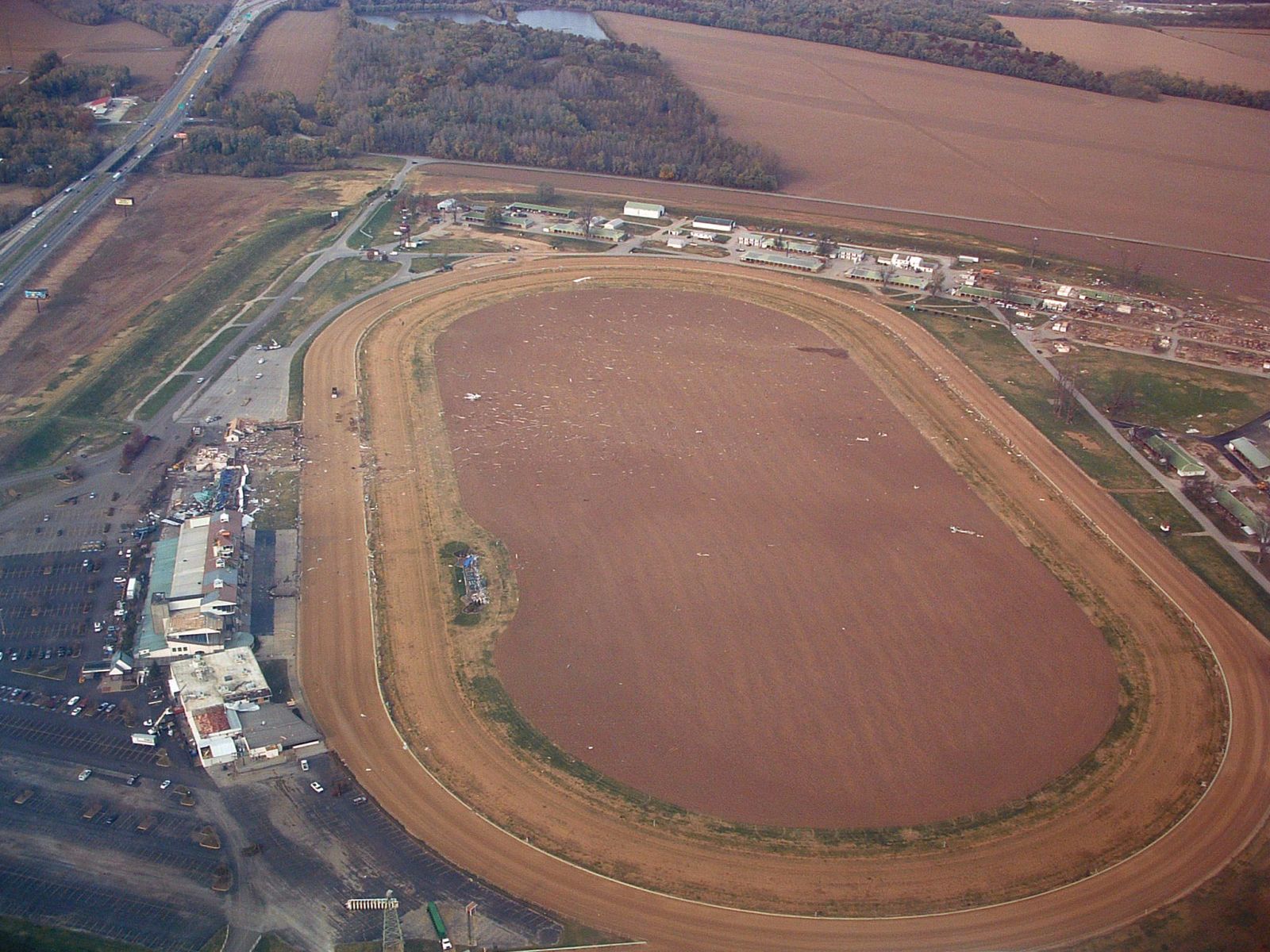
The tornado crossed the Ohio River for a second time and moved back into Henderson County, KY at 150 am. Henderson County KY was still under the tornado warning that was initially issued at 132 am. This part of Henderson county is a sparsely populated flood plain, used mostly for farming. The tornado then crossed the river a third time less than a mile west of the U.S. Highway 41 twin bridges. The river does not form the state line at the third crossing. From the bridges, extensive tree damage was visible along both sides of the Ohio River. Almost immediately after crossing the river, the tornado slammed into a horse racing facility named Ellis Park. There was extensive damage to grandstands and housing facilities for jockeys. A few race horses were killed. This facility was the first major facility to be impacted by the tornado. The tornado then crossed back into Vanderburgh County, Indiana after striking Ellis Park.
Damage to Ellis Park Horse Racing Track:

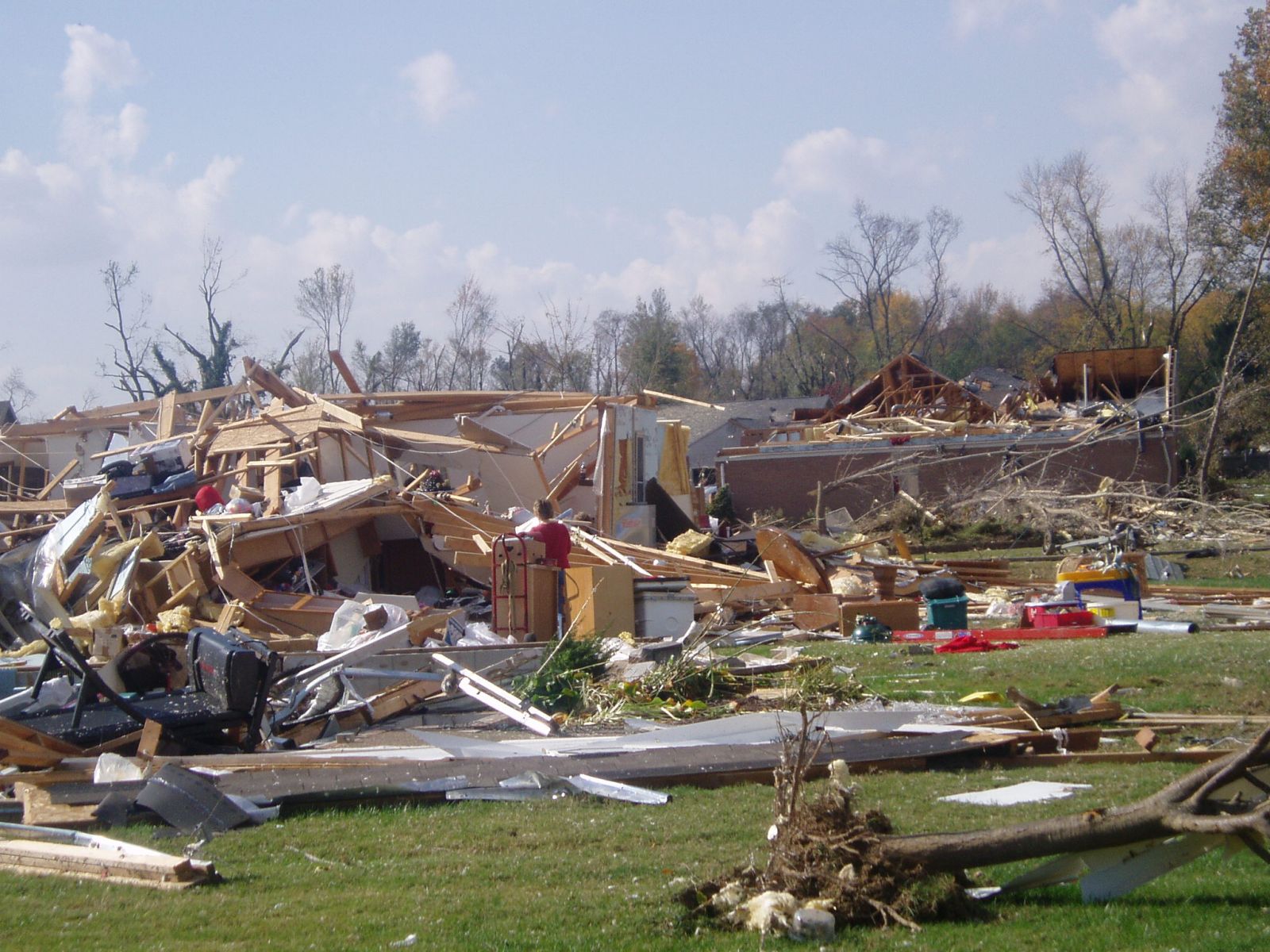
At 154 am, the tornado crossed back in Vanderburgh County IN. The tornado moved rapidly east-northeast at close to 60 MPH, staying a mile or less south of Interstate 164 and the southern city limit of Evansville. Shortly after 200 am, the tornado moved directly over Eastbrook mobile home park, which is on the south side of the interstate. Twenty people perished at this mobile home park. Of about 350 mobile homes in the park, 100 were completely destroyed and another 125 were damaged. Several of the fatally injured persons were found in a nearby retention pond that was drained to find victims. An 8-year-old child was found alive in a ditch after being trapped under debris for about 12 hours. One person died of complications from tornado injuries on December 17, 2005.
Damage pictures from Eastbook Mobile Home Park in Vanderburgh County, IN:


A tornado warning was issued by the NWS for Warrick County IN at 159 am. At 203 am, the tornado exited Vanderburgh County IN and crossed in Warrick County IN. Due to the extreme rate of speed, the tornado crossed the entire county in less than 20 minutes. The tornado reached its peak intensity in Warrick County, where winds reached about 200 MPH. The peak winds occurred along Highway 261 and Lincoln Road, in an industrial park near Paradise, and in DeGonia Springs. As the tornado passed south of Boonville, the county seat of Warrick County, a teenage girl was killed in a vehicle. In the community of DeGonia Springs, three persons in a mobile home were killed. One of the victims was a woman who was 8-months pregnant. From the north side of Newburgh to DeGonia Springs, houses were severely damaged or destroyed and vehicles were tossed. The tornado passed just to the south of Tennyson before exiting into Spencer County.

Damage pictures from Warrick County IN, in and near Newburgh:


.JPG)
.JPG)
Damage pictures of the Industrial park near Paraidse (Courtesy of Warrick County Emergency Mgmt):


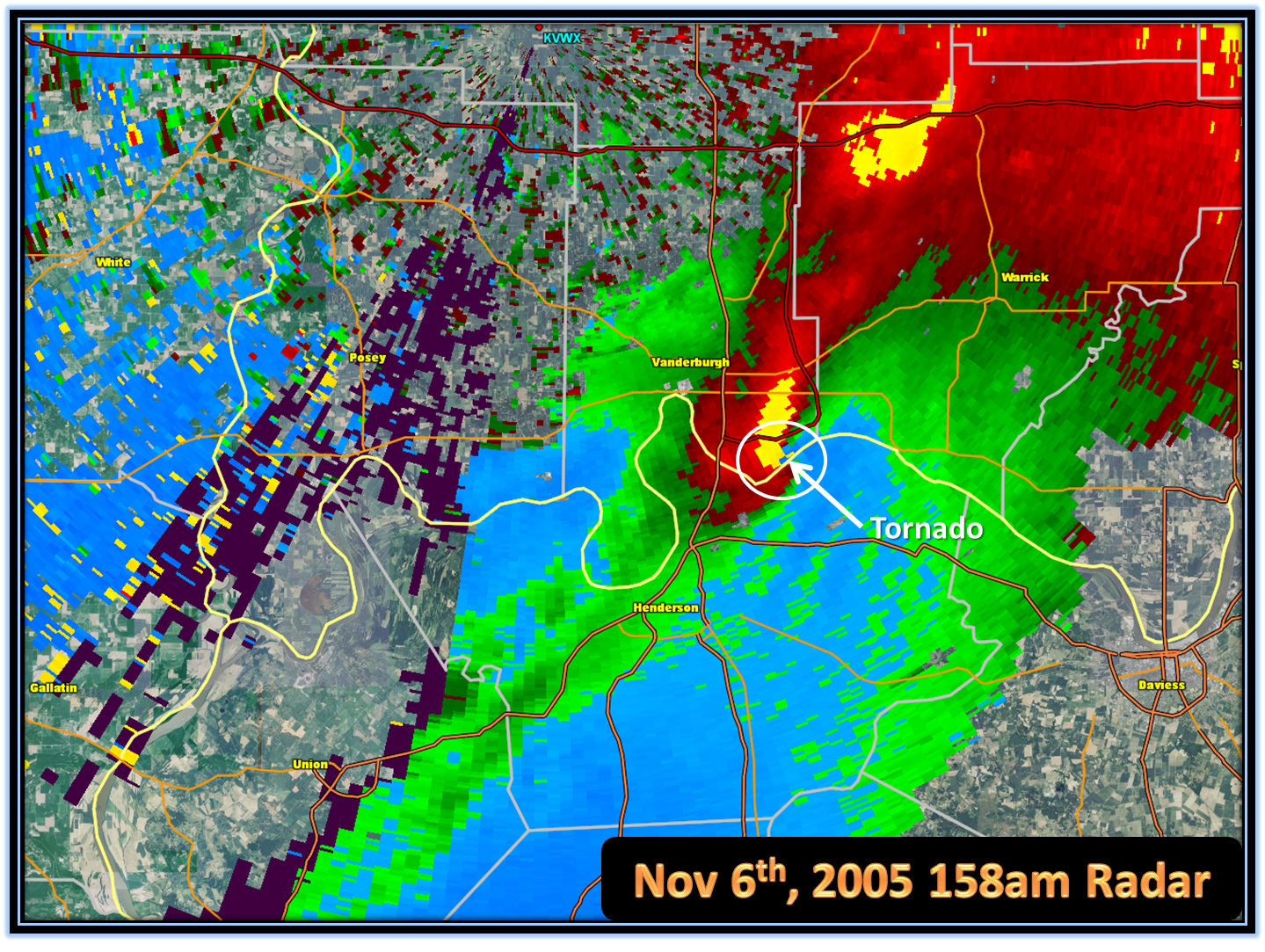
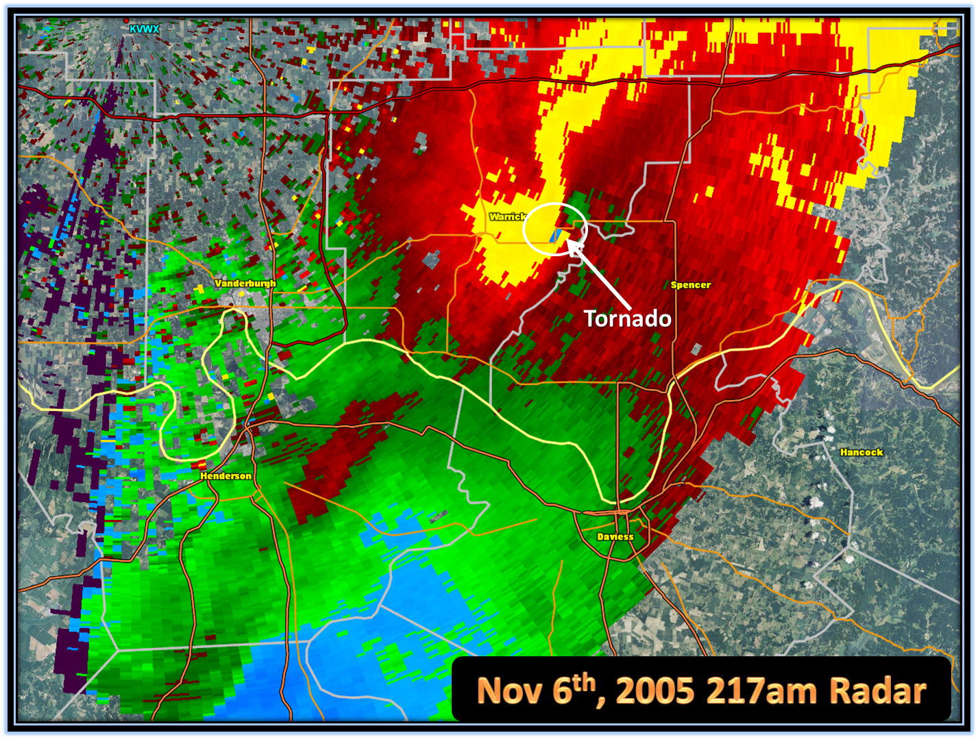
Radar picture showing the circulation as the tornado was passing just south of Boonville IN (Warrick County IN):

Damage pictures from near Boonville, IN:


Damage pictures from Warrick County IN - DeGonia Springs:


At 211 am, the last tornado warning for this tornado was issued for Spencer County IN. The tornado passed just to the south of Tennyson before exiting into Spencer County. The tornado crossed into Spencer County from Warrick County at 222 am just before dissipating. Some tin and insulation was found in a field at the end of the tornado track. The tornado was estimated to have weakened to F0 strength shortly before it entered Spencer County.
Radar picture showing the circulation as the tornado was about to pass south of Tennyson IN (Warrick County IN):
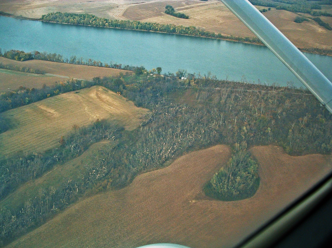
Here are some aerial pictures of the tornado track:


During the early morning hours of November 6 2005, a supercell thunderstorm spawned a deadly F3 tornado that impacted parts of northern KY and southwest IN. The environment that ultimately supported the development of this tornado (and another F3 tornado in western KY) evolved dramatically from about 6pm the evening before, with the most significant changes occurring in the 3 hours immediately prior to the tornado touching down.
On the weather maps, a low pressure system was centered over central Missouri, with a cold front extending southwest to north central Texas, and a warm front running northeast from the low to near Chicago, IL and then southeast into the Ohio Valley. The atmosphere was warm and relatively moist for early November. Winds at the surface were southerly and became southwesterly at about 5000 feet up. The best wind shear was concentrated in the lowest 5000 ft in the atmosphere. Bulk shear magnitudes for the layer between the surface and 20,000 ft was around 40 kts, which means that organized storms including supercells are possible. As we will see, the wind speeds at specific heights in the atmosphere will play a large role in the formation of this tornado.
Short term models were used to monitor the evolution of the environment during the evening and into the early morning hours before the tornado. Through the evening hours, the primary change that was occuring in the atmosphere involved an increase in the low level winds (low level jet), which jumped to 60 to 65 kts.
Even more changes would take place between 11pm and 2am. The approach of an upper level disturbance caused winds to increase in the mid levels of the atmosphere. Winds at 500 mb (~18,000 ft) increased to 80-85 kts by 2am and winds at 700 mb (~10,000 ft) increased to 60-65kts. There was already plenty of wind shear in the lower levels and aloft as well. By 2am, wind shear parameters became very favorable for supercells and tornadoes and this amount of wind shear was not noted earlier in the evening in previous model data.
Changes occurred with moisture content at the surface as well. As the line of storms to the west moved eastward, moisture surged northward and dewpoints crept into the lower 60s directly ahead of the cold front.
In summary, while there were signs of an improving environment for tornadic supercells, no available model guidance was able to create as favorable a tornadic environment as was observed.
The following graphics will help to illustrate the meteorology.

This image above shows the LAPS (data assimilation system) data at 1200am. It shows the strong low level winds (0-3000 ft) at 35-40 kts. You can see an increase in mid level winds (18,000-30,000 ft) approaching from the west.

Now we are at 1am: You can see how the approach of the faster mid level winds coincided with the strong low level winds. This created an increase in wind shear. Not too long after this juxtaposition occurred, two tornadoes touched down within a few minutes of each other, one of them being the beginning of the Evansville area tornado, which would stay on the ground for 41 miles.

This weather map above at 1am shows the surge of moisture northward due to the substantial increase in low level winds. This moisture pooled right ahead of the cold front and aided increasing the severity of the storms.

Having wind shear in the atmosphere is only part of the equation. We also had quite a bit of instability as well, especially for early November, due to the strong south winds ushering in the warm and moist air. This map shows the LAPS data at 1am indicating CAPE and Lifted Index, both measures of instability. You can see the bullseye of the greatest instability was over southwest IN and the northern Pennyrile region of west KY.

One parameter we use to analyze whether or not a storm has the ability to rotate, and hence, could produce tornadoes, is called helicity. On this LAPS data map at 1am, you can see the highest values (in yellow, orange and red) were located over southwest IN and the Pennyrile region of west KY.

