Workshop 1: Using ArcView and the Spatial Analyst to Derive Basin Characteristics
Required for ThreshR (Single Basin)
(Workshop developed for FFG/ThreshR training course, July 25-27,
2000)
INTRODUCTION
This workshop demonstrates how to use standard tools that are available
in ArcView and the Spatial Analyst and custom tools available in the AV-ThreshR
extension to derive basin parameters and threshold runoff (ThreshR) values
for a single basin at a time. Workshop 2 will show how some of the
standard ArcView features that are implemented manually in this workshop
have been strung together to make the complete, multi-basin AV-ThreshR
implementation.
Objectives:
-
explore ThreshR input data and gain an understanding of how ThreshR parameters
are computed
-
improve the user's ArcView and Spatial Analyst skills
These instructions assume the user has some familiarity with basic ArcView
features such as Pan and Zoom tools, Theme ordering, Legend editing, etc.
SETUP
Note: This setup will be done for you at the July Workshop.
On UNIX systems, copy the extension file threshr.avx to either
your Home directory or to the directory /ext under the ArcView3 installation
directory. [On a PC, copy threshr.avx to the ArcViewext32 directory.]
You can obtain the most recent version of threshr.avx via anonymous
ftp to ftp.nws.noaa.gov/oh/gis/threshr.
WORKSHOP INSTRUCTIONS
Problem statement: Compute the 1 hour threshold runoff
at USGS Gage 1546500 along Spring Creek Near Axemann, PA (77.790 W, 40.890
N) and at a nearby gage USGS 1558500 along Shaver C NR Petersburg PA (78.007
W, 40.611 N).
Characteristics of a unit graph for Spring Creek are known. The
1 hour unit graph has a peak flow of 2910.7 cfs and a basin lag of 8.67
hours.
These basins are located in USGS Region 5 of Pennsylvania. For
most states and regions, equations for several different return periods
are reported in USGS WRIR 94-4002. Most states report the 2 year
flooding flow Q2 which we are using as an approximation for the "flooding
flow." In Pennsylvania Region 5, the 2.33 year equation is provided
rather than the 2 year equation. For this exercise we will assume
that the Q2.33 is a good approximation for Q2. Thus, the Q2 equation
for Pennsylvania Region 5 is
Equation 1. 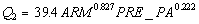
ARM = drainage area (mi2)
PRE_PA = an index equal to mean annual precip minus mean annual potential
evapotranspiration
Creating/Loading Data Sets
1. Start ArcView and load the AV-ThreshR Extension.
[This can be done by accessing the menu item File --> Extensions
when either a Project window or a View window is active. In the Extensions
dialog, scroll down the list of available Extensions and place a check
mark next to "ThreshR." To see information about the version number
of ThreshR in the "About" frame, click the mouse on the "ThreshR" text.
Threshr.avx is dependent on the Spatial Analyst so the Spatial Analyst
Extension is automatically loaded when the ThreshR extension box is selected.
An error will occur if the Spatial Analyst Extension is not available.]
2. At the UNIX prompt, create a new directory for output files
in your workspace using the UNIX "mkdir" command. E.G. "mkdir
output1" In ArcView, specify this directory as the project Working
Directory by clicking on
Project --> Properties with the Project
window active. Type the name of your output directory in the space
next to "Work Directory" and click OK.
3. Create a point shape file to display the location of the Spring
Creek and Shaver Creek stations.
-
Create a comma delimited ASCII file containing the ID, coordinates,
and field name in a header line. An example ASCII file is shown below.
The file you create MUST be created with a ".txt" extension.
Example ASCII file:
------------
id,usgsid,lon,lat
1,1546500,-77.790,40.890
2,1558500,-78.007,40.611
------------
-
Load this comma delimited ASCII file into ArcView as a Table (Hint:
Click
 once and click
the Add button. You have to select "List files of Type" Delimited
Text in the Add Table window). once and click
the Add button. You have to select "List files of Type" Delimited
Text in the Add Table window).
-
With a View active (create a new View if you have not already), click
View
--> Add Event Theme to create a new point Shapefile. An "Add
Event Theme" window will appear and you should select the Table you just
added and "Lon" as the X field and "Lat" as the Y Field.
-
The point Theme you have created is displayed in Geographic Coordinates
(decimal degrees). An easy way to tell if you are viewing points
in this coordinate system is by positioning your mouse cursor in the View
window and looking at coordinate values in the upper right corner
of the View window.
To display these gage points along with Av-ThreshR data sets, they
must be projected into the Albers Equal-Area projection with the same projection
parameters used for Av-ThreshR data. Load the Extension "Sp-coord".
A custom button is available in "Sp-coord" to project a point coverage
(only works for point coverages) into the appropriate projection  . .
-
Use the to
project your point Theme.
-
Delete the unprojected point Theme from your View since it is no
longer needed. (Edit --> Delete Themes.)
Note that a more general tool to project data Themes from
one projection to another is the ArcView "Projector!" extension available
for free from ESRI. Similar Theme projection functionality comes
standard with ArcView Version 3.2. Theme projection capabilities
only work with vector Themes NOT Grid Themes.
4. For reference, load the following Themes into the same View
as your projected station locations (Use the "Load Themes" button  ) )
./marfc/rf1.shp -- EPA's River Reach File 1 (modified by NOHRSC)
./marfc/rfcbndp.shp -- RFC boundary file
./marfc/regions.shp -- USGS Regions where different regression equations
apply.
./marfc/workshop1/padem -- DEM clipped for a portion of PA (units are
meters)
./marfc/workshop1/pafd -- flow direction grid clipped for a portion
of PA
./marfc/workshop1/pafa -- flow accumulation grid clipped for a portion
of PA
./marfc/workshop1/pafld -- flow length grid grid clipped for a portion
of PA
-
Zoom to the extent of these Themes once they are all loaded
 . .
-
If you wish, you can hide the default legends that are displayed with the
Grid Themes and take up a lot of space by making the Grid themes Active
(use the Shift key for multiple Themes) and clicking Theme -->
Hide/Show Legend.
Exploring the Input Data
5. Make the DEM Active and click Theme --> Properties to
get information about this Theme.
What is the cell size for this grid?
How many rows and columns are there?
What type of grid is this (Integer or floating point?)
-
You can view statistics for a grid Theme by double clicking on the Theme
name or Legend to get the "Legend Editor" window and then clicking on the
"Statistics" button.
What
are the maximum, minimum, and mean elevations for cells in this grid?
6. Just for fun, let's create a topographic relief map that appears
to be 3-D.
-
Make padem active.
-
Surface --> Compute Hillshade (use the default Azimuth
and Altitude). A Hillshade Theme is added to your View.
-
Double-click on padem to edit its legend.
-
In the legend editor, click "Advanced" and choose "Hillshade
of padem" as the Brightness Theme. Click OK
-
Select "Elevation # 1" as the Color Ramp to see a relief
map. You will need to scroll down in the Color Ramps combo-box to
see this option.
7. Move your stations Theme to the top of the Table of Contents
for display and Zoom into the vicinity of the gaging stations of interest
(Zoom Tool  ) )
8. Flow Directions. If you hid the Legend for the
Flow Direction Theme, unhide it by making pafd Active and clicking Theme
--> Hide/Show Legend. Doing this, you will see that there are
eight possible values for each cell in the Flow Direction grid. Make
the flow direction grid ("pafd") the active Theme and use the tracing tool  to visualize flow paths predicted by the flow direction grid. This
is a fun tool to play around with. The tracing tool creates graphics
(green lines) in the View window, not Themes. To remove these graphics,
select Edit --> Select All Graphics and then Edit --> Delete
Graphics.
to visualize flow paths predicted by the flow direction grid. This
is a fun tool to play around with. The tracing tool creates graphics
(green lines) in the View window, not Themes. To remove these graphics,
select Edit --> Select All Graphics and then Edit --> Delete
Graphics.
9. Flow Accumulation. Another way to visualize stream
flow paths is to create a synthetic stream network using the flow accumulation
grid. In Workshop 2, a synthetic stream network is generated
automatically by Av-ThreshR and used internally when multiple basins are
delineated. However, it's useful to see how these synthetic streams
can be defined manually using standard Spatial Analyst features.
-
Click Analysis --> Map Query and enter the following string
([pafa] < 500).setnull(1.asgrid)
Click Evaluate. A Theme named "Map Query 1" is added to your
View. Make this Theme visible to see the synthetic streams.
(Note: The "Map Query" window can be closed from the pull-down menu in
its upper-left hand corner.)
This string that you entered uses ArcView/Avenue syntax for Map Algebra.
The "Query" gets evaluated for each grid cell in the Analysis Extent (a
"per-cell function"). In plain English, this query reads: For
each cell with a flow accumulation lower than 500, assign the value NODATA.
Otherwise assign the value 1. 500 cells is equivalent to 80 km2 or
30.9 mi2 (500 * 0.16 km2/cell). The ArcView Map Algebra syntax takes
some getting used to.
The  tool
is provided with AV-ThreshR to make it easy to compute the cumulative drainage
area of individual grid cells in mi2 or km2 rather than in units of cells.
THE FLOW ACCUMULATION THEME MUST BE THE ACTIVE THEME in order for this
tool to give the correct result. Using this tool is nearly identical
to using the identify tool tool
is provided with AV-ThreshR to make it easy to compute the cumulative drainage
area of individual grid cells in mi2 or km2 rather than in units of cells.
THE FLOW ACCUMULATION THEME MUST BE THE ACTIVE THEME in order for this
tool to give the correct result. Using this tool is nearly identical
to using the identify tool  to query the flow accumulation grid except that it automatically converts
the number of cells upstream to mi2 and km2 rather than just reporting
the number of cells upstream.
to query the flow accumulation grid except that it automatically converts
the number of cells upstream to mi2 and km2 rather than just reporting
the number of cells upstream.
-
Make the flow accumulation Theme active and use the
tool to query the source points of some of the synthetic streams that resulted
from your Map Query. This will verify that the synthetic streams
begin when drainage area jumps above 30.9 mi2 or 500 grid cells.
10. Delineate Spring Creek and Back-calculate Snyder Cp
and Ct values.
For station 1546500 on Spring Creek we have a unit hydrogaph but we
do not have a unit hydrograph for station 1558500 on Shaver Creek.
If you have lost track of which station is which, just make the station
point Theme active and use the
.
To derive a Snyder unit hydrograph for Shaver Creek, we can using Cp
and Ct estimates computed from the data available at Spring Creek.
Cp and Ct values can be calculated for Spring Creek given the unit hydrograph
peak flow (cfs), the time to peak, the drainage area in square miles (ARM),
the length of the longest flowpath (CHLN), and the length from the basin
outlet to a point on the longest flow path opposite the centroid (CHCN).
-
Delineate the basin boundary for Spring Creek by making the flow
direction Theme "pafd" active and using the
 tool. To do this, it is helpful to zoom in close to the USGS gaging
station of interest so that you can select an individual stream cell
with
the mouse. Displaying your "Map Query 1" on top of "padem" will help
you to see which cells are "stream" cells. Using ,
select the stream cell nearest the USGS gage with the mouse.
When the delineation is complete, you will be asked to enter the name of
the output Shapefile. Suggested name: "Sprcreek.shp"
This Shapefile file is then added to your View along with a grid file of
the watershed boundary (by default the grid is named "Grid1" or "Grid2"
if "Grid1" exists, etc). Remove the check mark next to Grid1 since
this Theme is not needed until later.
tool. To do this, it is helpful to zoom in close to the USGS gaging
station of interest so that you can select an individual stream cell
with
the mouse. Displaying your "Map Query 1" on top of "padem" will help
you to see which cells are "stream" cells. Using ,
select the stream cell nearest the USGS gage with the mouse.
When the delineation is complete, you will be asked to enter the name of
the output Shapefile. Suggested name: "Sprcreek.shp"
This Shapefile file is then added to your View along with a grid file of
the watershed boundary (by default the grid is named "Grid1" or "Grid2"
if "Grid1" exists, etc). Remove the check mark next to Grid1 since
this Theme is not needed until later.
Of the geometric parameters need for the Snyder calculation, ARM
and CHLN are easy to compute manually while CHCN is slightly more complicated
(as discussed in Lecture). Thus, a simple Avenue script is provided
to calculate ARM, CHLN, and CHCN for you. This program also
calculates CHSL (also a more complex calculation) which is not needed for
the USGS Flood Frequency regression equation in this region, but is often
needed in other regions and is also needed if the "second" form of the
Snyder lag equation is used.
-
Make your Spring Creek polygon Theme active, and select your Spring Creek
basin polygon
 and then
click ThreshR-Utility --> Single Basin Geometry. Type
in the appropriate Theme names when the dialog comes up. This program
calculates the following parameters and adds them as attributes to the
subbasin Shapefile (sprcreek.shp). and then
click ThreshR-Utility --> Single Basin Geometry. Type
in the appropriate Theme names when the dialog comes up. This program
calculates the following parameters and adds them as attributes to the
subbasin Shapefile (sprcreek.shp).
ARM drainage area (sq.mi)
CHLN channel length (mi)
CHCN length to point on the main
channel opposite the centroid (mi)
CHSL USGS channel slope (ft/mi)
The program also adds three additional Themes to your View:
flow length grid (meters): "fld1"
grid representing the longest flow path: "lfpg1"
center point Shapefile: "cntp1.shp"
-
Open the attribute table for your basin Shapefile to see the results of
your calculations (use
 ). ).
-
To confirm that CHLN was calculated correctly, Display the Longest Flowpath
grid ("lfpg1"), make the Flow Length ("fld") active and query the flowlength
value on the most upstream cell in the longest flow path using .
The longest flowlength value in Spring Creek should be about 26300 m
or 16.35 miles.
You now have all of the information you need to estimate Cp and
Ct for this basin. The method for doing this is described by in Chow,
Maidment, and Mays, 1988 (p. 224-226). The sequence of calculations
required is summarized here:
' GIVEN VALUES
tpR = basin lag for the observed flow = 8.67 hrs
tR = duration = 1 hr
QpR = observed unit hydrograph peak (cfs) = 2910.7 cfs
'EQUATIONS
qpR = QpR / ARM = 2910.7 / ARM
'--- determine time to peak for the synthetic unit graph
tp=1.04762*(tpR-(tR/4))
'--- solve Applied Hydrology Eq. 7.7.2 for Ct
ct=tp/((CHLN*CHCN)0.3)
cp=qpR*tpR/640
You can make these calculations manually or run a utility script is
available in AV-ThreshrR to make these calculations for you:
-
Make sprcreek.shp the active Theme and run Threshr-Utility --> Cp and
Ct. Enter the known information and Cp and Ct will be calculated
based on the information in the fields "ARM", "CHLN", and "CHSL" of sprcreek.shp.
A report giving these values is displayed. In this example, Ct should
be about 2.0 and Cp should be about 0.5.
11. Calculate ThreshR for Spring Creek.
You need one more piece of information to calculate ThreshR for Spring
Creek. That information is the net Precipitation Index (PRE_PA)
used in the flood frequency regression equation for region 5 of Pennsylvania.
A grid of this precipitation index is provided for you in the "/marfc/pa"
directory.
-
Load the grid called "pre_pa" into your View using .
-
Calculate the mean value of PRE_PA for Spring Creek. To do this,
make the Spring Creek boundary Shapefile active and Select
Analysis --> Summarize Zones. Select "Gridcode" as the field
that defines the zones and select "Pre_pa" as the Theme containing the
variable to summarize. Just hit Cancel when you are asked to "Select
a statistic to chart:" because it is silly to make a Chart out of only
one data point.
A table titled "Stats of Pre_pa within the Zones of Sprcreek.shp"
is opened. The "Mean" field in this table is the mean value of PRE_PA
(inches) for Spring creek.
You can now calculate 1 hr threshold runoff (R1hr) using
Equation 1 to estimate flooding flow:
R1hr = Q2/QpR
Your result should be around 0.88.
12. Calculate ThreshR for Shaver Creek
-
Use to delineate the basin
boundary for Shaver Creek. (Remember the "pafd" grid must be Active).
The boundary for Shaver Creek looks quite blocky and maybe a little unusual
in shape. The boundary does make sense, however, when looking at
the shaded relief map created in Step 4. Also, remember that a basin
of this size is at the lower end of the size ranges where we can expect
reasanable accuracy in defining boundaries from the 400-m DEM. (Remove
the check mark next to "Grid2")
-
Maker your Shaver Cr. shapfile active and select the polygon boundary of
the basin (). Click
ThreshR
--> Single Basin Geometry
-
Compute the unit graph peak using the Snyder method and assuming the Ct
and Cp values are the same as those for Shaver Creek. Do this calculation
manually in this workshop. This calculation will be done automatically
in Workshop 2.
tp = Ct*(CHLN*CHCN)0.3
tr = tp/5.5
tpR = tp - (tr - tR)/4
QpR = 640*ARM*Cp/tpR
-
Compute the flooding flow using Equation 1 (Use Analysis --> Summarize
Zones again to compute mean PRE_PA for Shaver)
-
Estimate ThreshR as Q2/Qp. Answer should
be around 0.85 inches.
Congratulations! You have completed Workshop 1. Save
your project file in case you want it again later.
References
Chow, V.T., D.M. Maidment, and L.W. Mays, Applied Hydrology,
McGraw-Hill, INc., 1988.
Jennings, M.E., Thomas, W.O., and Riggs, H.C., "Nationwide Sumary of
U.S. Geological Survey Regional Regression Equations for Estimating Magnitude
and Frequency of Floods for Ungaged Sites, 1993" USGS Water-Resources
Investigations Report 94-4002, Reston, VA, 1994.
Notes:
USGS says the drainage area for Shaver Creek is 46.4 mi2 indicating
a DEM-based error of ~5.5%
USGS says the drainage area for Spring Creek is 87.2 mi2 indicating
a DEM-based error of ~9.6%
Assessment of the errors in drainage area delineation using the Av-ThreshR
flow directions will be discussed in a lecture.
|

