|
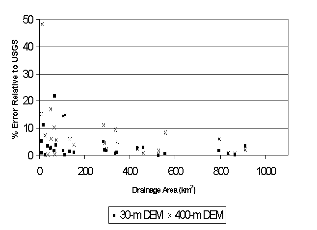
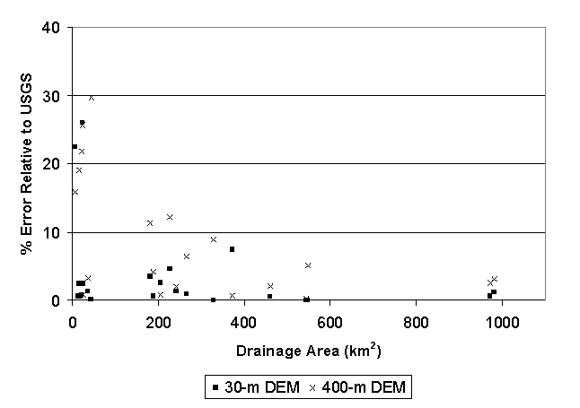
Taking drainage area estimates published by the USGS as a standard,
Figures 6.1 and 6.2 show the relative error (absolute values) in estimating
drainage areas using both the 400-m and 30-m DEM derivatives. Figure
6.1 shows results for basins with mild to moderate slopes in two Midwest
states (Oklahoma and Kansas), and Figure 6.2 shows results for basins with
mild to steep slopes in Northwestern Virginia. Locations in the Midwest
states are in the Illinois River Basin, the Blue River Basin, the Elk River
Basin, and the Marais Des Cygnes River basin. The Northwestern Virginia
locations are from the Shenandoah River valley.
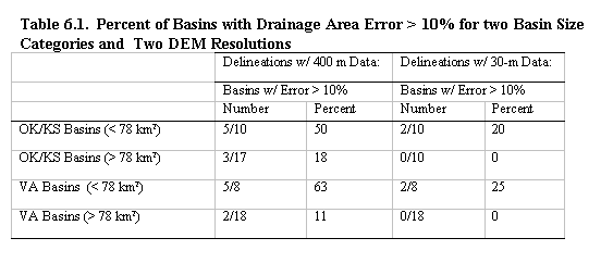
As expected, DEM-based drainage area estimates are less accurate for smaller basins. Table 6.1 summarizes the number of basins with drainage area estimation error greater than 10% using both 30-m and 400-m DEMs and for two basin size categories: basins smaller than 78 km2 (30 mi2) and basins larger than 78 km2 (30 mi2). The 30 mi2 threshold is somewhat arbitrary, but it was selected because this has been the rule of thumb for the smallest basin size to which the Integrated Hydrologic Automated Basin Boundary System (IHABBS) software can be applied ("NOHRSC GIS Applications Reference," 2001). IHABBS uses a very similar flow direction grid to the 400-m grid used here.
In both geographic locations, drainage area estimates for large basins and using the 400-m DEM are fairly good while drainage area estimates for small basins are poor. Of the 5 large (400-m delineated) basins with errors exceeding 10% (3 in the Midwest and 2 in Virginia), none of the errors for these basins exceeded 15%. For all locations, the average of the absolute values of errors for the small basin category is 6% using the 30-m DEMs and 18% using the 400-m DEMs. For the large basin category, the average errors are 1.6% and 3.9% respectively. This evidence confirms the rule of thumb that basins smaller than 78 km2 cannot be delineated using the 400-m DEM. This threshold may be larger in regions with milder slopes. |
|
Main Link Categories: Home | OHD | NWS |