|
RECOMMENDED BASELINE THRESHR PROCEDURES
Last Modified: Sept. 18, 2000
1. READ THIS IF you have already received ThreshR
data
2. Recommended Procedures
2.1 Changes in unit graph parameter
specification
2.1.1 Adding Cp and Ct or Ct2 Fields
2.1.2 Sources of information for Snyder
parameter estimates
2.1.3 Populating Cp and Ct fields with data
2.1.4 Length Correction Option
2.2 Other Changes/Notes
3. REFERENCES
1. READ THIS IF you have already received
ThreshR data (AB, MB, MA, and CB), otherwise proceed to Section II.
If you have not started using ThreshR or you just wish to start again
from scratch, I can resend your complete data set and you won't have to
do any of the steps in this section.
-
Change the filename of the grid "slopeff" to slopepct. To do this,
open a new empty project in ArcView. Open a new, empty View and choose
File à Manage Data Sources and then
use the Rename option in the File Ã
Manage Data Sources dialog.
-
The C Program for determining basin connectivity has been updated. Apparently
I was using C++ libraries that are available here at OH, but not at the
RFCs. I recoded the program so it only uses C. For those of you who have
already downloaded your data, you can simply replace the executable "idupstream"
located in your data directory with the file ftp.nws.noaa.gov/oh/gis/idupstream
(use binary ftp transfer to download this file). This program
is only needed if you choose the StreamLink basin delineation option and
use the ThreshR Ã Determine Connectivity
item with the C Program option turned on.
-
Some data corrections have been made.
Retrieve these files from ftp.nws.noaa.gov/oh/gis/data/<yourrfcname>
and replace the ones you have.
MA: parcode.dbf and regequat.dbf
MB: regequat.dbf
CB: regequat.dbf, rfcbound.shp, rfcbound.shx, rfcbound.dbf
Make sure to use binary ftp transfer when retrieving these files
-
If you have run ThreshR using v. 1.1, and you wish to continue working
with the same main View you were using, you should run ThreshR-Utility
Ã
Clear View Tag and then rerun ThreshR
Ã
Setup before proceeding.
2. Recommended Procedures
-
I recommend that you run ArcView/ThreshR on one of your AWIPS Workstations
("ws") rather than on the data server "ds." Your ArcView/Spatial Analyst
license should be a floating license so that you can run ThreshR on any
of your AWIPS workstations.
-
Follow the instructions from Workshop 2 using rfcbound.shp (in lieu of
wsusq.shp) to define your analysis area and noting the changes specified
below. The results will yield gridded ThreshR values representative of
basin sizes ranging from 20-35 mi2. You may also wish to run
the same procedures (still using the Headwaters1 basin delineation option)
with larger basin sizes to get a feel for how ThreshR values vary with
basin size. A range of cumulative basins (headwaters + non-headwaters)
can be examined using the Streamlink basin definition option, although
running the Headwaters1 option twice may be quicker than running the Streamlink
option once. If you run the Streamlink option, it is probably safest not
to select any of the advanced options although these should work.
Although technically feasible, it is not advisable to attempt to define
basin boundaries smaller than 20 mi2 using the DEM resolution
that is being delivered with AV-ThreshR v. 1.11. As we discussed at the
workshop, ThreshR values are somewhat sensitive to basin drainage area,
yet there is no consistent trend across the country as to whether ThreshR
values increase or decrease with drainage area.
2.1 Changes in unit graph parameter specification
The interface for unit graph calculations has been simplified to allow
for more flexibility in specifying Cp and Ct values. In addItion, the option
to use two different formulations for computing time to peak (lag) is also
included. These two lag equations were discussed in Lecture 4 at the July
25-27 Workshop, but are reproduced here for clarity in discussion.
Equation 1. 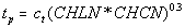
(Snyder, 1938.)
Equation 2. 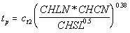
The new dialog interface for unit graph calculations looks like this:
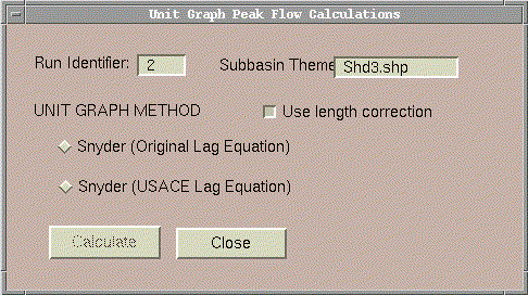
In order for the calculations to proceed, a field named "cp" and either
"ct" (If Original Lag Equation is selected) or "ct2" (If USACE Lag Equation)
must exist in the Subbasin Theme (shd3.shp in this case). If the Calculate
button is clicked and these fields cannot be found then the following message
will appear: "Must add cp and ct or ct2 field to shd1.shp."
2.1.1 Adding Cp and Ct or Ct2 Fields
-
Make the subbasin attribute table active and select Table Ã
Start Editing
-
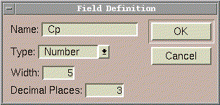
Select Edit à Add Field. Define a
numerical field (Width = 5 and Decimal Places = 3 should suffice for Cp,
Ct, or Ct2.
 The actual Cp and Ct estimates you wish to use can be added to these fields
in several ways discussed in Section 2.1.3.
The actual Cp and Ct estimates you wish to use can be added to these fields
in several ways discussed in Section 2.1.3.
2.1.2 Sources of information for Snyder
parameter estimates
-
Literature (see ranges below)
-
Back calculate from know unit graph as done in Workshop 1.
-
Call your Corps of Engineers District Offices
Parameter Ranges Cited in The Literature:
Snyder, 1938
Cp: 0.56 - 0.69
Ct: 1.8 - 2.2
Geographic Region: Appalachian Highlands
Buil, 1968
Cp: 0.77 - 2.45
Ct: 1.65 - 7.99
Geographic Region: Lower Missouri River in Kansas and Missouri
Miller, Kerr, and Spaeder, 1983
Cp: 0.24 - 0.67
Ct: 1.01 - 4.33
Geographic Region: Pennsylvania
HEC, 1989
Cp: 0.22 - 0.82
Geographic Region: Allegheny River Basin
USACE, 1959
Ct2: 0.35 for valley drainage, 0.72 for foothill drainage, 1.2 for
mountain drainage.
Geographic Region: In the vicinity of Los Angeles, CA
Carpenter and Georgakakos, 1993
Cp: 0.35 - 0.51
Ct2: 0.39 - 0.47
Geographic Region: Two streams in Iowa and one in Virginia
2.1.3 Populating Cp and Ct fields with data
Examples:
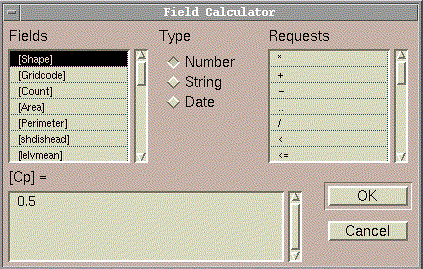
Define values for selected records using the Field Calculator  .
The field for which you wish to set values must be active. [Cp] was active
for the case shown below in which all selected subbasins are assigned the
value Cp = 0.5. .
The field for which you wish to set values must be active. [Cp] was active
for the case shown below in which all selected subbasins are assigned the
value Cp = 0.5.
Subbasin selections can be made either graphically using  or by using a tabular query
  .
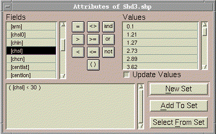
The tabular query option could be used, for example, if you wish to set
different ct or ct2 values for different ranges of channel slopes (CHSL).
This might be one way to distinguish between valley bottom (ct2 = 0.35),
foothills (ct2 = 0.72), and mountains (ct2 = 1.2). The dialog below illustrates
the selection of all subbasins with CHSL (channel slope) less than 30 ft/mile.
Use of this dialog could be followed by another Field Calculation ( .
The tabular query option could be used, for example, if you wish to set
different ct or ct2 values for different ranges of channel slopes (CHSL).
This might be one way to distinguish between valley bottom (ct2 = 0.35),
foothills (ct2 = 0.72), and mountains (ct2 = 1.2). The dialog below illustrates
the selection of all subbasins with CHSL (channel slope) less than 30 ft/mile.
Use of this dialog could be followed by another Field Calculation ( )
to set values for selected basins. Graphical selection would be useful
if you have an idea about parameter ranges for specific river basins. )
to set values for selected basins. Graphical selection would be useful
if you have an idea about parameter ranges for specific river basins.
Another useful button when setting table values is  ,
which toggles between selected and unselected records. ,
which toggles between selected and unselected records.
If you have been able to prepare a grid of Cp or Ct values like we used
in Workshop 2 then you may wish to populate the Cp, Ct, or Ct2 fields using
a grid. The menu item ThreshR - Utility Ã
Polygon Average from Grid allows you to do this.
When you are done editing your Cp and Ct attribute fields, click Table
Ã
Stop Editing.
2.1.4 Length Correction Option
An option to turn off or on the empirical length correction option is
now available. This option is turned on by default. These corrections are
used due to limitations with the DEM resolution (400-m cells) being used.
Lengths and slopes measured from the 400 m DEM are adjusted in an effort
to be closer to those used by the USGS to develop empirical relationships.
The empirical adjustment equations are similar to (but not identical to)
those presented in Lecture 6 from the July 25 Workshop).
2.2 Other Changes/Notes
-
When using ThreshR --> Q2, Q5 etc., you should now get a message if the
equations for the return period you have selected are missing for a particular
state. For example: In eastern Colorado, the USGS has not published the
2-year equations. The message you get is: "2 Year Equations May be Missing
for CO"
-
Although we have expended considerable effort in checking the regression
equation database, errors still may crop up. In several cases, errors
in the data tables can be detected by displaying ThreshR results and looking
for unusually high, unusually low, or missing values (-1). Let us
know if you see any problems.
-
-1 is now assigned to regions without available regression equations for
the return period selected (rather than 0).
-
A change to the Setup program now requires the user to specify the output
directory as well as the input directory. This automatically sets the project
working directory.
-
I'd be interested to know whether you feel that the Q5 may be a better
representation than Q2 for "flooding flow" in your area. I'm hoping to
make some comparisons of Q2 and Q5 with known bank full flows (i.e. at
locations with rating curves) to get a better feel for this.
-
In some regions, the USGS regression equations may be applicable only to
certain ranges of area or other parameters. Checking these applicability
limits is not currently built into the ThreshR software. In areas
I have tested, there are few problems with the basin sizes of interest
for ThreshR size basins. A few potential problem areas are mentioned in
the data
release notes, although this list is not
exhaustive.
-
For the parameter values added to your subbasin attribute table, constants
added or subtracted, or unit conversions required by the USGS equations
have already been made. Thus, use caution in interpreting these values.
The CHLN and CHSL values listed in the table do not reflect any empirical
length adjustments. These adjustments are hardcoded into ThreshR
--> Compute Q2, Q5, etc. and ThreshR --> UG Peak Flow.
3. REFERENCES
Buil, J. A, "Unit Graphs for Nonuniform Rainfall Distribution," Journal
of the Hydraulics Division, Proceedings of the American Society of
Civil Engineers, 235 - 257, January, 1968.
Carpenter, T.M., and K.P. Georgakakos, "GIS-Based Procedures in Support
of Flash Flood Guidance," Iowa Institute of Hydraulic Research (IIHR) Report
No. 366, November 1993.
Hydrologic Engineering Center, "Real-Time Flood Forecasting and Reservoir
Regulation for the Allegheny River Basin," Project Report No. 89-5, June
1989.
Miller, A.C., S.N. Kerr, and D.J. Spaeder, "Calibration of Snyder Coefficients
for Pennsylvania," Water Resources Bulletin, AWRA, pp. 625 - 630,
August 1983.
Snyder, F.F., Synthetic unit-graphs, Trans. Am. Geophys. Union,
vol. 19, pp. 447-454, 1938.
U.S. Army Corps of Engineers, Flood hydrograph analysis and computations,
Engineering and Design Manual, EM 1110-2-1405, U.S. Government Printing
Office, Washington, D.C., August 31, 1959.
|

