|
FORECASTING METHODOLOGY
Hydrologic
Methods for Forecasts
The conceptual methodology for developing numerical spring snowmelt outlooks (peak stage forecasts) in the upper Midwest has remained the same for decades. The process was originally developed and used by the Missouri Basin RFC prior to the creation of the North Central RFC in 1979. The methodology utilizes the same forecasting system (the OFS subsystem of NWSRFS) used to model and develop short-range flood forecast guidance. As such, all watershed components (headwaters and locals) and routing reaches are identical with respect to parameterization, data requirement, physical state, and output. Spring snowmelt outlooks are based on one scenario of future temperature and two scenarios of future precipitation. The scenario of future temperature reflects a normal spring warm-up that generates a single snowmelt peak during the month of April. The two scenarios of future precipitation are (1) zero future precipitation and (2) climatological normal precipitation. Procedurally, the outlook simulations are generated by making deterministic
"runs" that begin with the current operational model states and extend 60 days
into the future. Since the OFS can only support a 30-day forecast run, the process must be
run in two steps of 30 days each. While this is awkward, it does not affect the accuracy
of the guidance. For simplicity, climatological normal precipitation (scenario #2) through
the end of the forecast period is added to the current model-state snowpack at the start
of the run. Since these runs are only used to assess the potential spring peak rather than
the time-series of spring runoff, this simplification is reasonable. Once the two
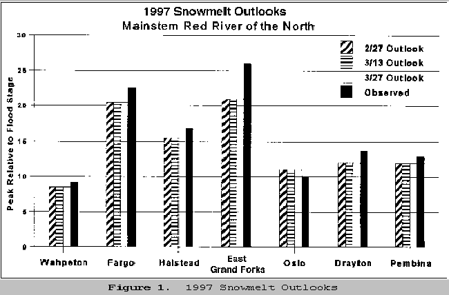
simulations are made, RFC hydrologists review the model guidance for each forecast point. The 1997 outlooks for the Red River of the North are presented in Figure 1; values shown are the second scenario; i.e., they include climatologically normal future precipitation. Note that later outlooks did not change the values from the late February outlooks. The observed crest at all points except East Grand Forks is within 1-2 feet of the outlook and generally 1-2 feet above the previous record stage. At East Grand Forks, the observed crest stage of 54.35 feet is 5.35 feet above the outlook and 5.55 feet above the previous record stage.
History of Outlooks for the Red River of the North Spring Outlook peaks issued for Wahpeton, North Dakota; Fargo, North Dakota; and East Grand Forks, Minnesota, for years 1980 through 1997 are shown below (Table 3). These are the outlooks issued around March 15 (or earlier) each year. Note that in very low snow years, no outlook value was provided. The last three columns are (1) forecast snowmelt peak with zero future precipitation , (2) forecast snowmelt peak with climatologically average future precipitation, and (3) observed peak stage.
Table 3. History of Spring Flood Outlooks for the Red River of the North
The NCRFC has developed the ability to provide probabilistic spring flood outlooks for the Des Moines Basin using the Ensemble Streamflow Prediction (ESP) procedure of NWSRFS. Both traditional (as were done for the Red River of the North) and ESP forecasts for the Des Moines Basin were generated during the Spring of 1997. The ESP procedure was not implemented for the Red River of the North during the 1997 floods.
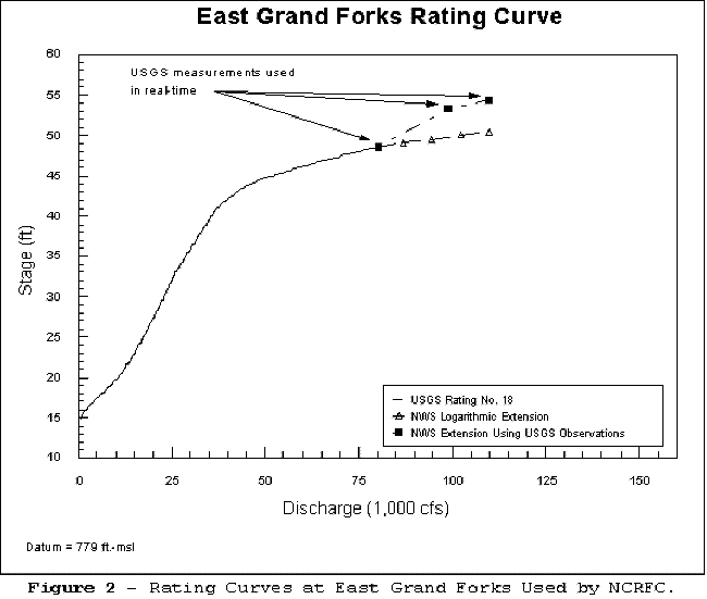
While hydrologic modeling is based on flow volumes, most public forecasts are made for river levels or stages. The relationship between river stage and flow volume rate (discharge) is called a rating curve or stage-discharge relation. These rating curves are critical to forecasting the river stages at gaged locations along rivers. The USGS is responsible for measuring streamflow throughout the United States. The USGS makes discharge measurements and develops most of the official rating curves used by the NWS. When significant rises occur, the USGS makes additional discharge measurements and routinely provides the information to the NWS, the USACE, and other cooperators. These measurements are used to update rating curves. The rating curves are developed based on actual flow measurements; the USGS does not normally extend them beyond observed flows. Rating curves are used extensively in the OFS to convert observed stage data into discharge for routing water to downstream points. They are also used to convert discharge at a forecast point into stage values for issuing public forecasts. In some events, the forecast flow or stage is beyond the uppermost value in the rating curve for that location. For those cases, OFS will extend the rating curve by one of three methods: linear extrapolation, logarithmic extrapolation, or hydraulic extension. The method used to extend the curve is defined by the forecaster when setting up the rating curve in OFS. These automatic extensions work well in many situations and are used to provide estimated values until an updated rating curve is available. The extensions may not work well in other situations, especially when significant backwater effects are present. The rating curve in use at the NCRFC for forecasting at the East Grand Forks gage is shown in Figure 2; it includes the portion of the rating curve based on previous (to the flood) observations of the USGS (noted as USGS Rating No. 18), the logarithmic extension within OFS used for forecasting by the NCRFC, and the extension of the rating based on the observations taken during the flood.
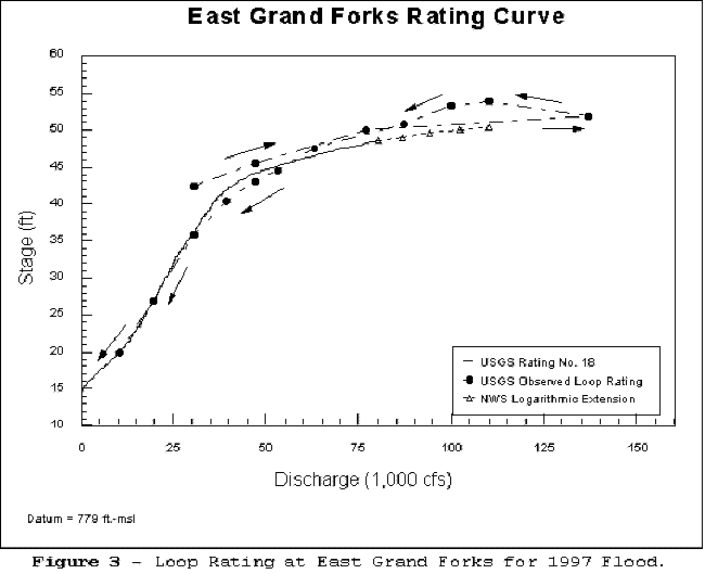
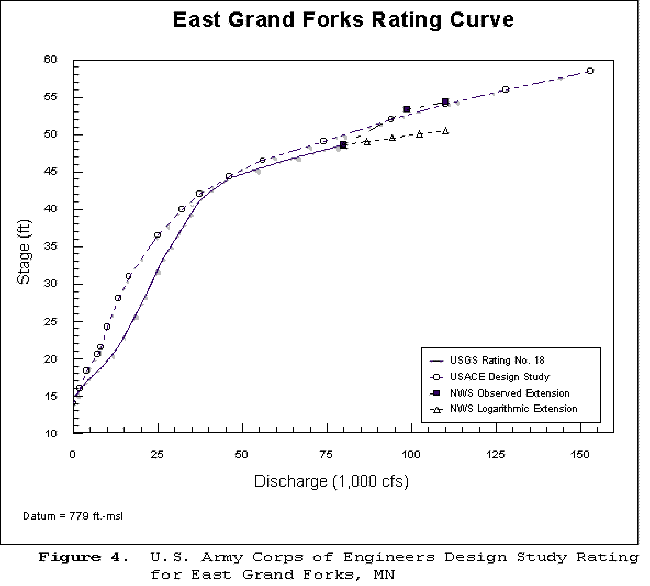
The variable stage-discharge relation at East Grand Forks makes it inherently difficult to provide a highly accurate prediction of flood crests (especially for extreme events) there. The discharge measurements made by the USGS during the April 1997 flooding show that the stage varied as much as 6 feet for a discharge of 30,000 cubic feet per second (cfs). Historically, the stage at a discharge of 30,000 cfs has varied between 36 and 40 feet but was affected this year by backwater from downstream ice on the rising limb of the hydrograph to increase the range to 6 feet. Near the peak, the discharge varied from 100,000 to 137,000 cfs while the stage varied between 52 and 54 feet. Measurements made during previous floods show similar variation in the relation between stage and discharge. The discharge measurements made by the USGS during the April flooding define a loop rating for the East Grand Forks forecast location based on the April 1997 event, but this rating is only representative of conditions during the 1997 flood. The shape and relative position of rating (relation of stage to discharge) varies considerably from year to year depending on ice conditions, debris accumulation, and the volume of runoff flowing into the river at and downstream from Grand Forks. The rating for any individual flood can only be defined precisely with discharge measurements during the flood, which severely restricts the NWS ability to provide an accurate long-range forecast of the flood crest. Using the existing methodology, future flood forecasts should be based on the most recent stage-discharge rating but presented in the context of the range of stages that have been experienced at the predicted peak discharge. Extensions of the rating curves, based on hydraulic analysis, are routinely done for flood insurance studies by the Federal Emergency Management Agency (FEMA) or during project design by the USACE, city engineers, or other planning agencies. While these engineering analyses may not be directly applicable to a real-time forecast situation, they should be considered on a case-by-case basis to aid NWS forecasters, especially for record and near-record floods. The USACE had such a rating curve for an unbuilt project in Grand Forks. In a post-analysis of the flood forecasting at Grand Forks, the St. Paul District Office of the Corps concluded:
An interagency review by the NWS, USGS, and USACE to examine the extension of the existing rating curves at all forecast points in the Red River Basin could provide an efficient mechanism to improve forecast methods. Since most rating curves provided by the USGS are based on historical records, an effort should be made to review all critical rating curves and any additional information to see if a rating curve can be extended based on information in flood insurance studies, USACE project studies, etc. This review should also confirm that the RFC has current copies of all relevant engineering studies, etc., for the basins in their forecast area. Although a single-valued rating curve cannot define conditions completely, existing single-valued rating curves for all points along the Red River of the North should certainly be updated with new ones developed from the 1997 data. This should be accomplished through the usual process of updates by the USGS based on the 1997 data. To achieve maximum accuracy in stage forecasts at East Grand Forks, a considerably more complex hydraulic routing model than the one available during the 1997 flood would be needed. The implementation of such a model needs to establish the performance of the new routing for a variety of historical floods, including the 1997 flood, and the sensitivity of the routing model to real-time observations to account for ice effects and other year-to-year variations. Since it will be used in real-time forecasting, stability of the solution procedures under a wide range of flows must be assured as well. An hydraulic analysis (see Appendix B) has been performed to
understand the hydraulic characteristics that led to the difference between the NWS
forecast stage at East Grand Forks based on the NWS simulated hydrograph using the initial
extended rating curve used by the NWS and the actual stage at East Grand Forks. The
analysis concludes that this difference (which totals ~3.8 feet) is due to the following
factors: the effects of the very mild channel slope which produced an unsteady loop rating
effect (2.0 feet), the effects of the bridges (0.8 foot), the fact that the NWS simulated
discharge hydrograph did not capture the peak discharge which occurred early in the event
(well before the peak stage) (0.4 foot), effects from the overtopping of the levees in the
Grand Forks area (negligible), and unexplained effects (0.6 foot). A detailed discussion
of these effects is contained in Appendix B.
The variable stage-discharge relation for the Red River of the North at East Grand
Forks is not unique. Such variable relations can occur on any river with very flat slopes
or reaches of rivers affected by inflows from major tributaries or tides. Acting together,
the NWS and USGS have the ability to conduct a joint review of all NWS forecast locations
to determine which ones could be affected significantly by variable stage-discharge
relations in future flood forecasts and whether the use of a looped rating numerical model
is warranted on the basis of improved forecast accuracy.
While the two scenarios of snowmelt peaks have been provided for many years, they lack information that allows NWS users to better assess a reasonable level of risk. Further, the user is provided with scenarios of zero and normal future precipitation; but a scenario that reflects above average future precipitation is not provided. NWSRFS supports the ability to develop probabilistic long-range forecasts through the Ensemble Streamflow Prediction (ESP) process. ESP provides a frequency distribution of future outcomes (e.g., peak streamflows) that can be sampled at any desired level of exceedance and associated risk . The streamflow simulation model currently deployed in the Red River of the North (Kansas City API) cannot provide an objective estimate of forecast uncertainty and is not compatible with ESP. Although it will require a multi-year effort and significant resources, the best method to improve the Spring Outlook process is to make a series of significant investments in NWS forecast procedures. These all point toward implementing ESP to produce the spring snowmelt outlooks at several levels of exceedance probability. This would allow NWS customers to have an objective basis to assess a reasonable level of risk and better understand the uncertainty associated with the guidance values. Implementation of ESP will require the calibration of a continuous streamflow simulation model; such as, the Sacramento Soil Moisture Accounting (SMA) model. The NCRFC should develop a phased plan for recalibration of the Red River of the North using a model that is compatible with ESP. Consideration of river ice effects on stage will also have to be considered within an ESP implementation used for Spring Outlooks. Implementation of the Advanced Hydrologic Prediction System (AHPS) (demonstrated in
1997 in the Des Moines River Basin) which includes ESP and probabilistic flood inundation
mapping would provide additional information to users as to where flooding might occur in
cities along the Red River of the North.
Ponded Surface Water Not Modeled It was observed that much of the meltwater remained ponded on fields due to the very
flat terrain and snow and ice that initially blocked culverts until these temporary
obstructions melted. NWSRFS does not contain a hydrologic operation that will model the
temporary storage of meltwater that accumulates before conveyances open and allow movement
to the stream channel. This inadequacy was circumvented subjectively by manually reducing
the melt rate prior to runoff and then enhancing the melt rate once runoff began.
The NWS Form E-19 conveys site-specific information regarding river forecast locations to forecasters who have often never seen the site for which they are forecasting. Accurate and complete information in the E-19s is critical to the forecast process at RFCs and WFOs. The E-19 information for the Red River of the North forecast points could be improved and expanded to include additional information to aid forecasting (which is a common issue for the entire NWS hydrologic services program). E-19s focus on the history of floods and their impacts and on information about measurements at the site. E-19s usually do not include detailed information on local structures and topography that might affect floods at levels above the historical floods; e.g., at the time of the flood, the E-19 for East Grand Forks, Minnesota, did not include a description of the five bridges that cross the Red River of the North within the city. (The only reference to a bridge was that the railroad bridge becomes inoperative at 50 feet.) The established flood stage of 28 feet at East Grand Forks is well below the level that causes damage in Grand Forks itself, due to the levee protection that is in place, although at the 28-foot level certain actions are needed in the city infrastructure and minor flooding may begin upstream. The Eastern North Dakota office in Grand Forks should review and update the existing
E-19s for the Red River Basin, including the defined flood stages. These should include
updated impacts and photographs of the surrounding area. The plans for future use of the
E-19 information in digital form to control product formatting provides added impetus to
these updates.
The NCRFC provided stage but not discharge values in its forecast products. In
conferences with the USACE and others, both stage and discharge values were discussed by
NCRFC staff (at least at some points). Including discharge in selected forecast products
would provide additional information to sophisticated users (emergency managers, city
engineers, USACE, etc.) to independently evaluate the assumed stage-discharge
relationship.
At record flood levels, water may flow in areas where it has never been observed to
flow before, including overland flows of water across low points between two streams.
Transbasin flows were reported by observers in numerous locations during the 1997 Red
River of the North flood event. This information was useful qualitatively, but the
condition made forecasting more difficult. At a few locations where transbasin flows are
fairly common, the current forecast system has empirical procedures that estimate these
flows, but the current forecasting system cannot estimate these flows at locations where
they rarely (in some cases never before 1997) occur, and there was no quantitative
estimate of the amount of transbasin flow that could have been used to make adjustments in
the current forecast system. Even if a dynamic wave model were installed for the Red River
of the North, it would require significant additional effort to model transbasin flows
with geographic information system methods applied to high-resolution topographic
information (which is not currently available) to extend the model to include definition
of topographic features that allow transbasin flows to occur.
Snow Surveys and April Blizzard Effects The National Operational Hydrologic Remote Sensing Center (NOHRSC) conducts airborne snow surveys which provide critical information for forecasting in the upper Midwest. In 1997, NOHRSC conducted seven airborne surveys over the Red River of the North Basin (see timeline in Appendix A). This unusually large number of surveys was the result of the exceptional snow conditions in the area. Two of these surveys are of special note: The first survey, conducted on February 6-9, 1997, provided much of the justification for the earliest outlook that characterized the potential for spring flooding as "severe." The blizzard that struck the Red River of the North Basin in early April dramatically
altered the hydrologic situation. Data collection and communications were seriously
hampered, and full assessment of the storm's impact on the hydrology was not possible for
nearly a week after the storm ended. Generally, crest outlook values would not have been
exceeded if this blizzard had not occurred. Responding to a request by the NCRFC, the
National Operational Hydrologic Remote Sensing Center (NOHRSC) of the NWS Office of
Hydrology terminated an airborne snow survey in progress elsewhere and collected snow
water data for the Red River of the North on April 9-12. The basin estimates provided to
the NCRFC on April 13 provided critical information. This was especially true since much
of precipitation data required by the model to simulate snow cover was unavailable as a
result of communication failures caused by the severe blizzard conditions.
Current spatial snow water estimation procedures do not make full and optimal use of
all available information. Further, the spatial estimates for basins are provided to the
model as "perfect" data without regard to the potential for introduced bias or
variance. The NOHRSC is developing a Snow Estimation and Updating System for the Eastern
U.S. that will allow integration of the ground-based, airborne, radar, and satellite snow
data to derive snow water equivalent estimates and optimally update the snow model.
|