National Weather Service United States Department of Commerce
 
 
 Early Season Snow November 15-16, 2018
 
 
 Synopsis
  • An early season snowstorm impacted the Tri-State region November 15-16, 2018 producing widespread snowfall accumulations of 1 inch to over 18.3 inches at Mt. Hope in Orange County.
  • Despite the region being prepared for a snow event, areas along the I-95 corridor were severely impacted, more-so than anticipated 24 hours earlier.
  • The storm was quick moving, but had devastating impacts as it struck at the heart of rush hour traffic.
    • Snow began shortly after 1PM increasing in intensity and quickly lowering visibility.
    • Central Park reported heavy snow and 1/4 mile visibility from 2:43pm through 3:51pm and by 7pm, had received 6.0".
    • JFK airport reported heavy snow and 1/4 mile visibilty from 3:00pm through 3:45pm before reporting moderate snow until 4:30pm. By 4pm, JFK had 3.2" on the ground and by 7pm received 4.8".
    • LaGuardia airport first began reporting moderate snow at 3:50pm before picking up in intensity briefly at 4:48pm. Moderate snow then continued until 5:45pm. By 7pm, LGA had 4.5" on the ground.
    •  
     Impacts
  • Over 1,000 flights were canceled at Kennedy, LaGuardia and Newark airports on Thursday.
  • Hundreds of trees were brought down by heavy snow across the region with over 150 down in New York City alone.
  • A 20 car accident backed up traffic on the George Washington Bridge which had a cascading effect on other roads. Numerous other accidents were reported across the Tri-State area.
  • There were system-wide delays and cancellations on the Long Island Railroad, New Jersey Transit and Metro North Railroad.
     Other Facts
  • Daily snowfall records for November 15th were set at Central Park (6.4"), Kennedy (4.8"), LaGuardia (4.7"), Newark (6.4"), and Islip (4.3").
  • Central Park set a record for the most snow observed for a storm this early in the season since records have started in 1869. It broke a previous record of 4.3" which fell on November 7, 2012.
  • Kennedy Airport set a record for the most snow observed for a storm this early in the season since records have started in 1948. It broke a previous record of 4.0" which fell on November 7, 2012.
  • LaGuardia Airport set a record for the most snow observed for a storm this early in the season since records have started in 1940. It broke a previous record of 4.0" which fell on November 6, 1953.
  • Newark Airport set a record for the most snow observed for a storm this early in the season since records have started in 1931. It broke a previous record of 5.7" which fell on November 7, 2012.
  • Islip Airport set a record for the most snow observed for a storm this early in the season since records have started in 1963. It broke a previous record of 4.0" which fell on November 27, 1978.
 
Snowfall Summary


Regional Observed Snowfall


regsnow


Snowfall Reports Listing
 
New York
LOCATION          STORM TOTAL     TIME/DATE   COMMENTS                   
                     SNOWFALL           OF 
                     /INCHES/   MEASUREMENT

...Bronx County...
   Pelham Parkway House   6.8   850 PM 11/15  Public                  
   Dodgewood              6.0   600 PM 11/15  CoCoRaHS                

...Kings County...
   Sheepshead Bay         5.0   630 PM 11/15  Trained Spotter         
   1 NE Sheepshead Bay    4.3   500 PM 11/15  Public                  
   Midwood                4.1   645 PM 11/15  Broadcast Media         
   1 SSW Bergen Beach     4.0   700 PM 11/15  NYC OEM CERT            

...Nassau County...
   Manhasset              6.5   750 PM 11/15  Trained Spotter         
   North Massapequa       5.6   655 PM 11/15  Social Media            
   Syosset                5.5   657 PM 11/15  Trained Spotter         
   Plainview              5.0   530 PM 11/15  Trained Spotter         
   East Williston         5.0   730 PM 11/15  Public                  
   Bethpage               5.0   639 PM 11/15  Public                  
   Manorhaven             4.9   745 PM 11/15  Trained Spotter         
   Albertson              4.5   700 PM 11/15  CoCoRaHS                
   New Hyde Park          4.5   900 PM 11/15  Amateur Radio           
   Wantagh                4.5   635 PM 11/15  Trained Spotter         
   Massapequa             4.0   740 PM 11/15  CoCoRaHS                

...New York County...
   Central Park           6.4   100 AM 11/16  Park/Forest Srvc        
   Stuyvesant Town        5.9   715 PM 11/15  NYC OEM CERT            
   East Harlem            5.2  1143 PM 11/15  CoCoRaHS                
   Upper West Side        4.8   715 PM 11/15  NYC OEM CERT            
   1 WNW Ravenswood Hou   4.3   535 PM 11/15  NYC OEM CERT            

...Orange County...
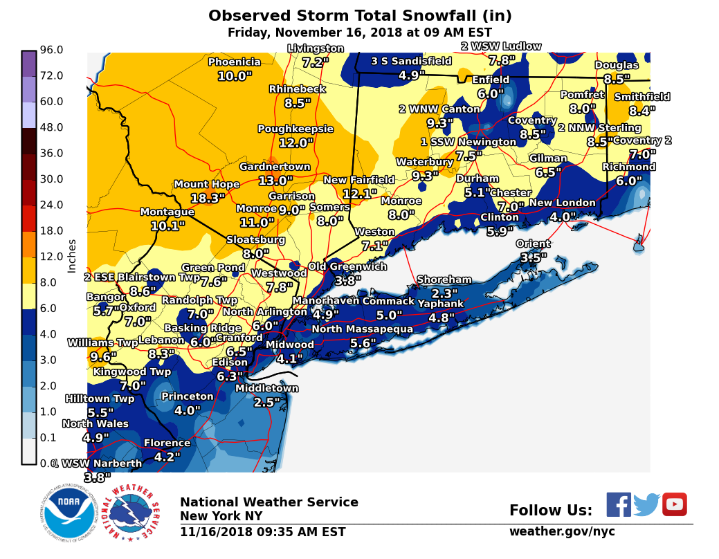
   Mount Hope            18.3  1045 PM 11/15  Trained Spotter         
   Gardnertown           13.0  1027 PM 11/15  Trained Spotter         
   Newburgh              11.3   930 PM 11/15  Trained Spotter         
   Walden                11.0   805 PM 11/15  CoCoRaHS                
   Montgomery            10.5   730 PM 11/15  Trained Spotter         
   Goshen                10.2  1000 PM 11/15  Trained Spotter         
   Highland Mills        10.2  1000 PM 11/15  Trained Spotter         
   Vails Gate            10.0   810 PM 11/15  Trained Spotter         
   Otisville             10.0   850 PM 11/15  Public                  
   Middletown             9.2   830 PM 11/15  Fire Dept/Rescue        
   Monroe                 9.0   800 PM 11/15  Trained Spotter         
   Cuddebackville         9.0   600 PM 11/15  Trained Spotter         
   New Windsor            9.0   730 PM 11/15  Trained Spotter         
   Warwick                9.0  1045 PM 11/15  Trained Spotter         
   Westtown               8.8  1045 PM 11/15  Social Media            

...Putnam County...
   Patterson              8.5  1000 PM 11/15  Public                  
   Brewster               7.6   900 PM 11/15  Trained Spotter         
   Putnam Valley          7.4   900 PM 11/15  Broadcast Media         
   Cold Spring            7.1   815 PM 11/15  Trained Spotter         
   Mahopac                7.0   930 PM 11/15  Trained Spotter         

...Queens County...
   Astoria                5.7   730 PM 11/15  Public                  
   Whitestone             5.4   800 PM 11/15  Public                  
   Rego Park              5.0   645 PM 11/15  Trained Spotter         
   Kennedy Airport        4.8   100 AM 11/16  FAA Observer            
   NYC/LaGuardia Airpor   4.7   100 AM 11/16  FAA Observer            
   Elmhurst               4.7   700 PM 11/15  Trained Spotter         
   Jamaica                3.8   745 PM 11/15  NYC OEM CERT            
   Little Neck            3.8   610 PM 11/15  Trained Spotter         
   Howard Beach           3.5   900 PM 11/15  Amateur Radio           
   Middle Village         3.2   635 PM 11/15  CoCoRaHS                
   Flushing               3.0   750 PM 11/15  Trained Spotter         

...Richmond County...
   Dongan Hills           3.8   730 PM 11/15  Public                  

...Rockland County...
   Sloatsburg             8.0   800 PM 11/15  Trained Spotter         
   Upper Nyack            7.3   830 PM 11/15  Social Media            
   New City               6.8   945 PM 11/15  Trained Spotter         
   Chestnut Ridge         6.6   900 PM 11/15  Public                  
   Spring Valley          6.5   830 PM 11/15  Social Media            
   Nyack                  5.0   547 PM 11/15  Public                  

...Suffolk County...
   North Babylon          5.3   800 PM 11/15  Public                  
   Commack                5.0   645 PM 11/15  Public                  
   Medford                5.0   700 PM 11/15  Trained Spotter         
   Sayville               4.9   545 PM 11/15  Public                  
   Yaphank                4.8   600 PM 11/15  Public                  
   Upton                  4.6   700 PM 11/15  NWS Office              
   Islip Airport          4.3   100 AM 11/16  FAA Observer            
   Smithtown              4.1   530 PM 11/15  Trained Spotter         
   Port Jefferson         4.0   630 PM 11/15  Public                  
   West Islip             4.0   550 PM 11/15  Trained Spotter         
   Dix Hills              4.0   745 PM 11/15  Social Media            
   Farmingville           3.8   615 PM 11/15  Trained Spotter         
   Ridge                  3.6   730 PM 11/15  CoCoRaHS                
   Bay Shore              3.6   900 PM 11/15  NWS Employee            
   Orient                 3.5   900 PM 11/15  Trained Spotter         
   Miller Place           3.3   745 PM 11/15  Public                  
   Mount Sinai            3.2   630 PM 11/15  Public                  
   Lindenhurst            3.1   500 PM 11/15  Public                  

...Westchester County...
   Jefferson Valley       8.5   925 PM 11/15  Trained Spotter         
   Somers                 8.0   750 PM 11/15  Social Media            
   Croton-On-hudson       7.4  1100 PM 11/15  Trained Spotter         
   White Plains           7.0   900 PM 11/15  Public                  
   Ossining               7.0   800 PM 11/15  Trained Spotter         
   Hastings-On-hudson     7.0  1245 AM 11/16  Public                  
   Armonk                 6.8   825 PM 11/15  CoCoRaHS                
   Mount Kisco            6.7   800 PM 11/15  Public                  
   Bronxville             6.3   700 PM 11/15  Public                  
   Yorktown Heights       6.2   655 PM 11/15  Public                  
   Pelham                 5.0   900 PM 11/15  Amateur Radio           
   Rye Brook              4.5   900 PM 11/15  Amateur Radio           

&&    
   
Connecticut


LOCATION          STORM TOTAL     TIME/DATE   COMMENTS                   
                     SNOWFALL           OF 
                     /INCHES/   MEASUREMENT

CONNECTICUT

...Fairfield County...
   New Fairfield         10.9  1130 PM 11/15  Trained Spotter         
   Newtown                8.2   945 PM 11/15  HAM radio               
   Monroe                 8.0  1030 PM 11/15  Trained Spotter         
   Bethel                 8.0   900 PM 11/15  Emergency Manager       
   Danbury                7.9   800 PM 11/15  Public                  
   Shelton                7.1   930 PM 11/15  Trained Spotter         
   Weston                 7.1   925 PM 11/15  Trained Spotter         
   Brookfield             7.0   815 PM 11/15  CoCoRaHS                
   Ridgefield             7.0   810 PM 11/15  Trained Spotter         
   Old Greenwich          6.8   900 PM 11/15  Trained Spotter         
   Darien                 6.8   930 PM 11/15  Trained Spotter         
   Easton                 6.5   905 PM 11/15  Public                  
   New Canaan             6.4   950 PM 11/15  Trained Spotter         
   Stratford              4.5   700 PM 11/15  CoCoRaHS                
   Greenwich              4.0   645 PM 11/15  Trained Spotter         
   Stamford               3.8   624 PM 11/15  Amateur Radio           

...Middlesex County...
   Chester                7.0   720 PM 11/15  Trained Spotter         
   Durham                 5.0   720 PM 11/15  Trained Spotter         
   Old Saybrook           3.5   910 PM 11/15  Amateur Radio           

...New Haven County...
   Waterbury              9.3  1130 PM 11/15  Trained Spotter         
   Cheshire               7.7   930 PM 11/15  Trained Spotter         
   Wallingford            7.5  1115 PM 11/15  Trained Spotter         
   Middlebury             7.5   900 PM 11/15  Social Media            
   Wolcott                7.5   820 PM 11/15  Broadcast Media         
   Woodbridge             7.0   910 PM 11/15  Trained Spotter         
   Seymour                6.8   945 PM 11/15  Trained Spotter         
   Hamden                 6.5   945 PM 11/15  Trained Spotter         
   Branford               6.5   915 PM 11/15  Trained Spotter         
   Guilford               6.5   820 PM 11/15  Broadcast Media         
   Naugatuck              5.0   651 PM 11/15  Amateur Radio           
   North Haven            5.0   720 PM 11/15  Trained Spotter         
   New Haven              4.6   645 PM 11/15  Public                  
   Stony Creek            4.5   730 PM 11/15  Trained Spotter         
   Madison                4.0   725 PM 11/15  Amateur Radio           

...New London County...
   Gilman                 6.5  1030 PM 11/15  Public                  
   Old Lyme               5.5   905 PM 11/15  Public                  
   New London             4.0   805 PM 11/15  CoCoRaHS                
   Ledyard Center         4.0   830 PM 11/15  Trained Spotter         


New Jersey
LOCATION          STORM TOTAL     TIME/DATE   COMMENTS                   
                     SNOWFALL           OF 
                     /INCHES/   MEASUREMENT

NEW JERSEY

...Bergen County...
   Westwood               7.8   915 PM 11/15  Trained Spotter
   Allendale              7.5   810 PM 11/15  Public
   Englewood Cliffs       7.2   525 AM 11/16  Trained Spotter
   Franklin Lakes         7.2   800 PM 11/15  Trained Spotter
   Washington Township    6.9   830 PM 11/15  Trained Spotter
   Ridgewood              6.7   700 PM 11/15  Trained Spotter
   Park Ridge             6.5   700 PM 11/15  HAM radio
   North Arlington        6.0   715 PM 11/15  Trained Spotter

...Essex County...
   Cedar Grove            7.1   900 PM 11/15  Public
   West Orange            7.0   700 PM 11/15  Public
   West Caldwell          6.9   735 PM 11/15  Trained Spotter
   Maplewood              6.5   845 PM 11/15  CoCoRaHS
   Bloomfield             6.5  1125 PM 11/15  Public

...Hudson County...
   Kearny                 6.0   930 PM 11/15  Public
   Harrison               5.8  1245 AM 11/16  Co-Op Observer
   Hoboken                4.7   715 PM 11/15  Public

...Passaic County...
   Hawthorne              7.0   930 PM 11/15  Public
   North Haledon          6.3   822 PM 11/15  Public
   Bloomingdale           5.2   915 PM 11/15  Trained Spotter

...Union County...
   Cranford               6.5  1041 PM 11/15  Social Media
   Plainfield             6.5   540 PM 11/15  Trained Spotter
   Newark Airport         6.4   100 AM 11/16  FAA Observer
   Roselle Park           6.0   900 PM 11/15  Social Media
   Westfield              6.0   605 PM 11/15  Public


Peak Wind Gusts
 

LOCATION             MAX WIND     TIME/DATE   COMMENTS
                        GUST            OF
                         MPH    MEASUREMENT

CONNECTICUT

...Fairfield County...
   Bridgeport Airport      45  1250 AM 11/16  ASOS

...New London County...
   Groton Airport          43   100 AM 11/16  ASOS

NEW JERSEY

...Union County...
   Newark Airport          41  1046 PM 11/15  ASOS
   Linden Airport          40  1135 PM 11/15  AWOS

NEW YORK

...Kings County...
   1 WNW Rockaway Beach    53  1135 PM 11/15  CWOP
   Flatbush                41   725 AM 11/16  NYSM

...Nassau County...
   Bayville                58  1201 AM 11/16  WXFLOW
   Jones Beach CG          54   138 AM 11/16  WXFLOW
   Wantagh                 44   300 AM 11/16  NYSM

...Queens County...
   1 S Jackson Heights     46  1153 PM 11/15  CWOP
   Breezy Point            46   739 AM 11/16  WXFLOW
   NYC/JFK Airport         45   748 AM 11/16  ASOS
   NYC/La Guardia          44  1202 AM 11/16  ASOS
   Whitestone              43   442 AM 11/16  CWOP

...Suffolk County...
   Great Gull Island       67   326 AM 11/16  WXFLOW
   Shinnecock              64   333 AM 11/16  WXFLOW
   Napeague                59   355 AM 11/16  WXFLOW
   Fishers Island Airpo    59   345 AM 11/16  WXFLOW
   Point O Woods YC        57   105 AM 11/16  WXFLOW
   Mecox Bay               55   307 AM 11/16  WXFLOW
   Fire Island CG          55   111 AM 11/16  WXFLOW
   East Moriches CG        52   152 AM 11/16  WXFLOW
   Eatons Neck             52   934 PM 11/15  WXFLOW
   1 E East Moriches       52   219 AM 11/16  CWOP
   Peconic                 52   320 AM 11/16  NYSM
   East Hampton            47   335 AM 11/16  AWOS
   3 WSW Gilgo State Pa    46   130 AM 11/16  CWOP
   Westhampton Airport     45   100 AM 11/16  ASOS
   Sinai Harbor            44   100 AM 11/16  WXFLOW
   Cutchogue               44  1218 AM 11/16  CWOP
   Farmingdale Airport     43   828 AM 11/16  ASOS
   Great South Bay         42   815 AM 11/16  WXFLOW
   1 SE West Islip         41   234 AM 11/16  CWOP

...Westchester County...
   Larchmont Harbor        62  1216 AM 11/16  WXFLOW
   Tappan Zee Light 14     41   633 AM 11/16  WXFLOW
   White Plains Airport    41   756 AM 11/16  ASOS


Meteorology
 
National Weather Service Doppler Radar (KOXK) Imagery
The following loop is OKX radar reflectivity beginning at 18 UTC (1 pm) and continuing every 30 minutes until 0430 UTC (11:30 pm) on November 16. The yellow, oraneg and red colors on the reflectivity images (greater than 30 dBZ) indicate moderate to heavy snow bands. Several of these bands moved north during the evening commute. The precip transitioned to a wintry mix and then rain especially at the coast between 00 UTC and 02 UTC (7 pm and 9 pm).


Weather Prediction Center (WPC) Surface Analysis 11 am Thursday 11/15 through 1 am Friday 11/16
Hover over the times above to view Weather Prediction Center (WPC) Surface Analysis beginning at 11 am on November 15 and every 3 hours until 1 am on November 16.


300mb Heights(m) and Winds(kt)
Hover over times above to view 300mb analysis beginning at 1 pm on November 15 and every 3 hours until 11 pm on November 15. The color shading are wind speeds in knots and the purple contours are divergence. Areas of diverence at 300mb are indicitive of large scale upward motion as the region was situated in a favorable upper level jet stream set up. There were two jet streams influencing the vertical motion over the northeast, with one departing New England and one approaching from the southeast.  


700mb Heights(m), Frontogenesis, and Temperatures (°C)
Hover over times above to view 700mb heights (m), frontogenesis, and temperatures (°C) beginning at 1 pm on November 15 and every hour until 12 am on November 16. The 8 pm data was unavailable and is not shown here. Areas of frontogenesis are contoured in purple. Dashed contours are temperatures. The enhanced area of frontogenesis is one of the ingredients that led to the bands of heavy snow during the evening commute on November 15.
Watch/Warning Service
 
A Hazardous Weather Outlook (HWO) was issued at 5:35 AM Wednesday morning, specificially highlighting the impact for the Thursday evening commute.
    A coastal low will bring a wintry mix to the area late Thursday into early Friday. The Thursday evening commute will be impacted. Accumulating snow and sleet can be expected at the onset, before changing over to rain and freezing rain overnight. Hazardous travel is possible.

A Winter Weather Advisory was posted at 2:41 PM Wednesday for the CWA with the exception of NYC and Long Island for the potential for 2 to 4 inches of snow. Snowfall was forecast for NYC and Long Island but for lesser amounts, which were not expected to meet advisory criteria.

A Winter Weather Advisory was expanded at 12:29 PM Thursday for NYC and Western Long Island for the potential for 2 to 5 inches of snow, with snowfall rates of 1 inch per hour possible.

A Winter Storm Warning was issued at 12:29 PM Thursday for northeastern NJ and the lower Hudson Valley for the potential for 4 to 7 inches.