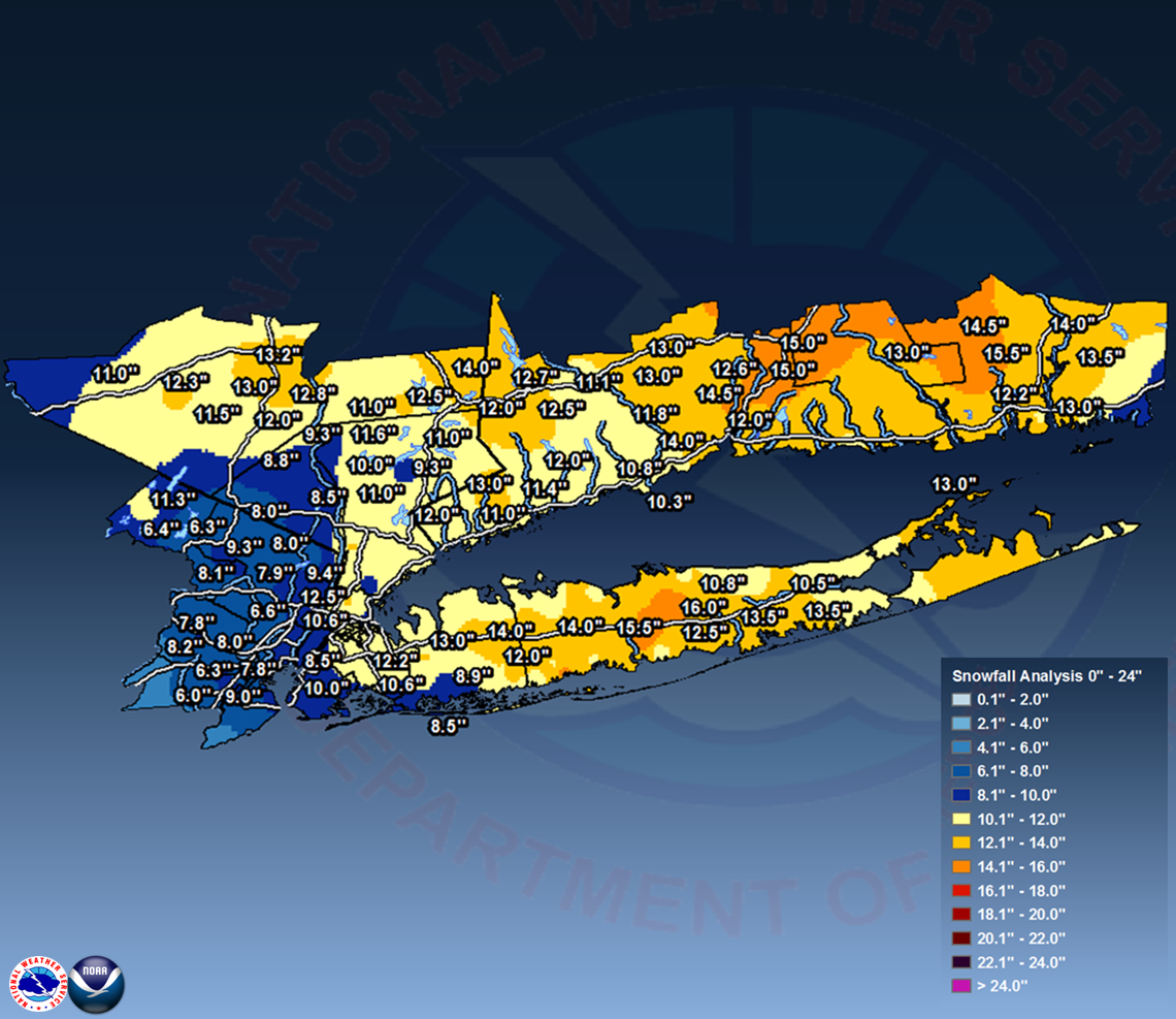
New York, NY
Weather Forecast Office
 |
| New York |
LOCATION          STORM TOTAL     TIME/DATE   COMMENTS
                     SNOWFALL           OF
                     /INCHES/   MEASUREMENT
...BRONX COUNTY...
   2 NNW BRONX           12.5   324 PM  2/09  PUBLIC
   BRONX                 10.6   315 PM  2/09  BRONX ZOO
   1 ENE UNIONPORT        9.5   515 PM  2/09  CO-OP OBSERVER

...KINGS COUNTY...
   MIDWOOD               10.0   500 PM  2/09  PUBLIC
   MARINE PARK            9.5   400 PM  2/09  PUBLIC
   SHEEPSHEAD BAY         9.0   430 PM  2/09  TRAINED SPOTTER
   CLINTON HILL           8.5   310 PM  2/09  TRAINED SPOTTER
   1 SSW BERGEN BEACH     7.0   600 PM  2/09  COCORAHS

...NASSAU COUNTY...
   HICKSVILLE            14.0   430 PM  2/09  PUBLIC
   JERICHO               13.0   545 PM  2/09  SOCIAL MEDIA
   NEW HYDE PARK         12.2   700 PM  2/09  AMATEUR RADIO
   ROSLYN                12.0   615 PM  2/09  PUBLIC
   NORTH MASSAPEQUA      12.0   500 PM  2/09  PUBLIC
   GLEN COVE             12.0   615 PM  2/09  PUBLIC
   BETHPAGE              12.0   615 PM  2/09  PUBLIC
   OLD BROOKVILLE        12.0   615 PM  2/09  PUBLIC
   GARDEN CITY           12.0   615 PM  2/09  PUBLIC
   EAST MEADOW           11.2   700 PM  2/09  TRAINED SPOTTER
   MALVERNE              10.6   330 PM  2/09  TRAINED SPOTTER
   OYSTER BAY            10.0   515 PM  2/09  TRAINED SPOTTER
   FREEPORT               8.9   700 PM  2/09  AMATEUR RADIO
   LONG BEACH             8.5   430 PM  2/09  PUBLIC
   ROCKVILLE CENTRE       8.0   445 PM  2/09  PUBLIC

...NEW YORK COUNTY...
   CENTRAL PARK           9.4   400 PM  2/09  PARK CONSERVANCY

...ORANGE COUNTY...
   NEW WINDSOR           13.2   500 PM  2/09  PUBLIC
   VAILS GATE            13.0   315 PM  2/09  TRAINED SPOTTER
   CORNWALL ON HUDSON    12.8   345 PM  2/09  TRAINED SPOTTER
   GOSHEN                12.3   347 PM  2/09  TRAINED SPOTTER
   FORT MONTGOMERY       12.0   430 PM  2/09  TRAINED SPOTTER
   MONROE                11.5   533 PM  2/09  TRAINED SPOTTER
   MIDDLETOWN            11.0   531 PM  2/09  TRAINED SPOTTER

...PUTNAM COUNTY...
   MAHOPAC               12.5   355 PM  2/09  TRAINED SPOTTER
   LAKE PEEKSKILL        11.6   400 PM  2/09  PUBLIC

...QUEENS COUNTY...
   CEDAR MANOR           11.8   530 PM  2/09  COCORAHS
   MIDDLE VILLAGE        11.5   400 PM  2/09  COCORAHS
   1 WSW WALDEN TERRACE  10.6   316 PM  2/09  COCORAHS
   OAKLAND GARDENS       10.6   355 PM  2/09  AMATEUR RADIO
   NYC/LA GUARDIA        10.0   400 PM  2/09  FAA OBSERVER
   WHITESTONE            10.0   700 PM  2/09  AMATEUR RADIO
   NYC/JFK AIRPORT        8.3   400 PM  2/09  FAA OBSERVER

...ROCKLAND COUNTY...
   STONY POINT            8.8   545 PM  2/09  TRAINED SPOTTER
   CONGERS                8.5   418 PM  2/09  TRAINED SPOTTER

...SUFFOLK COUNTY...
   SELDEN                16.0   700 PM  2/09  AMATEUR RADIO
   BOHEMIA               15.5   530 PM  2/09  PUBLIC
   BABYLON               15.3   715 PM  2/09  SOCIAL MEDIA
   LAKE RONKONKOMA       15.1   655 PM  2/09  TRAINED SPOTTER
   ISLIP AIRPORT         14.3   700 PM  2/09  FAA OBSERVER
   HAUPPAUGE             14.0   500 PM  2/09  NWS EMPLOYEE
   NORTH BABYLON         14.0   500 PM  2/09  PUBLIC
   SETAUKET              14.0   500 PM  2/09  PUBLIC
   SMITHTOWN             13.8   500 PM  2/09  SOCIAL MEDIA
   ISLIP                 13.6   530 PM  2/09  TRAINED SPOTTER
   COMMACK               13.5   445 PM  2/09  PUBLIC
   MILLER PLACE          13.5   615 PM  2/09  PUBLIC
   UPTON                 13.5   700 PM  2/09  NWS OFFICE
   EASTPORT              13.5   500 PM  2/09  PUBLIC
   EAST ISLIP            13.5   715 PM  2/09  TRAINED SPOTTER
   ORIENT                13.0   734 PM  2/09  TRAINED SPOTTER
   SOUTH HUNTINGTON      12.9   530 PM  2/09  TRAINED SPOTTER
   PATCHOGUE             12.5   623 PM  2/09  NWS EMPLOYEE
   SAINT JAMES           12.5   745 PM  2/09  TRAINED SPOTTER
   LINDENHURST           12.3   645 PM  2/09  TRAINED SPOTTER
   WEST ISLIP            12.0   600 PM  2/09  TRAINED SPOTTER
   MATTITUCK             11.8   500 PM  2/09  TRAINED SPOTTER
   WEST BABYLON          11.7   330 PM  2/09  TRAINED SPOTTER
   BAY SHORE             11.4   500 PM  2/09  NWS EMPLOYEE
   MOUNT SINAI           11.0   630 PM  2/09  CO-OP OBSERVER
   COPIAGUE              11.0   700 PM  2/09  AMATEUR RADIO
   KINGS PARK            11.0   340 PM  2/09  AMATEUR RADIO
   SOUND BEACH           10.8   500 PM  2/09  PUBLIC
   RIVERHEAD             10.5   430 PM  2/09  NWS EMPLOYEE
   SAYVILLE              10.4   400 PM  2/09  PUBLIC
   GREENLAWN             10.3   343 PM  2/09  PUBLIC
   RIDGE                 10.2   515 PM  2/09  NWS EMPLOYEE

...WESTCHESTER COUNTY...
   DOBBS FERRY           12.8   400 PM  2/09  PUBLIC
   ARMONK                12.0   515 PM  2/09  PUBLIC
   WHITE PLAINS          11.8   515 PM  2/09  AMATEUR RADIO
   SOMERS                11.0   530 PM  2/09  TRAINED SPOTTER
   JEFFERSON VALLEY      11.0   545 PM  2/09  TRAINED SPOTTER
   OSSINING              11.0   515 PM  2/09  AMATEUR RADIO
   IRVINGTON             10.3   600 PM  2/09  PUBLIC
   1 SSW HARMON          10.0   430 PM  2/09  TRAINED SPOTTER
   HASTINGS-ON-HUDSON    10.0   600 PM  2/09  PUBLIC
   MOUNT VERNON           9.5   445 PM  2/09  PUBLIC
   MOUNT KISCO            9.3   400 PM  2/09  PUBLIC
   PEEKSKILL              9.3   358 PM  2/09  TRAINED SPOTTER
|
| Connecticut |
LOCATION          STORM TOTAL     TIME/DATE   COMMENTS
                     SNOWFALL           OF
                     /INCHES/   MEASUREMENT
...FAIRFIELD COUNTY...
   NEW FAIRFIELD         14.0   730 PM  2/09  TRAINED SPOTTER
   NEW CANAAN            13.0   500 PM  2/09  CT DOT
   BROOKFIELD            12.7   630 PM  2/09  TRAINED SPOTTER
   BETHEL                12.5   730 PM  2/09  FIRE DEPT/RESCUE
   DANBURY               12.0   515 PM  2/09  AMATEUR RADIO
   WESTON                12.0   400 PM  2/09  TRAINED SPOTTER
   1 W SHELTON           11.8   430 PM  2/09  COCORAHS
   2 ENE NEW CANAAN      11.4   430 PM  2/09  TRAINED SPOTTER
   NEWTOWN               11.1   425 PM  2/09  COCORAHS
   NORWALK               11.0   615 PM  2/09  PUBLIC
   BRIDGEPORT AIRPORT    10.3   400 PM  2/09  CO-OP OBSERVER

...MIDDLESEX COUNTY...
   HADDAM                13.0   500 PM  2/09  CT DOT
   OLD SAYBROOK          13.0   500 PM  2/09  CT DOT

...NEW HAVEN COUNTY...
   WALLINGFORD           15.0   341 PM  2/09  TRAINED SPOTTER
   MERIDEN               15.0   500 PM  2/09  CT DOT
   HAMDEN                14.5   630 PM  2/09  TRAINED SPOTTER
   WEST HAVEN            14.0   500 PM  2/09  PUBLIC
   BEACON FALLS          13.0   500 PM  2/09  CT DOT
   WATERBURY             13.0   500 PM  2/09  CT DOT
   CHESHIRE              12.6   345 PM  2/09  TRAINED SPOTTER
   NEW HAVEN             12.0   500 PM  2/09  CT DOT
   MADISON               11.8   830 PM  2/09  PUBLIC
   MILFORD               10.8   500 PM  2/09  CT DOT

...NEW LONDON COUNTY...
   SALEM                 15.5   400 PM  2/09  PUBLIC
   COLCHESTER            14.5   500 PM  2/09  CT DOT
   NORWICH               14.0   700 PM  2/09  CT DOT
   LEDYARD CENTER        13.5   700 PM  2/09  TRAINED SPOTTER
   GROTON                13.0   500 PM  2/09  CT DOT
   QUAKER HILL           12.2   530 PM  2/09  TRAINED SPOTTER
   NEW LONDON            11.5   345 PM  2/09  PUBLIC
STONINGTON 9.5 400 PM 2/09 COCORAHS |
| New Jersey |
LOCATION          STORM TOTAL     TIME/DATE   COMMENTS
                     SNOWFALL           OF
                     /INCHES/   MEASUREMENT
...BERGEN COUNTY...
   1 W TENAFLY            9.4   430 PM  2/09  COCORAHS
   FRANKLIN LAKES         9.3  1150 AM  2/09  PUBLIC
   LYNDHURST              8.0  1215 PM  2/09  AMATEUR RADIO
   MAHWAH                 8.0  1151 AM  2/09  TRAINED SPOTTER
   WESTWOOD               8.0  1045 AM  2/09  TRAINED SPOTTER
   RIDGEWOOD              7.9  1214 PM  2/09  TRAINED SPOTTER
   EAST RUTHERFORD        6.6   348 PM  2/09  TRAINED SPOTTER
   OAKLAND                6.3  1022 AM  2/09  TRAINED SPOTTER
   HARRINGTON PARK        6.0  1023 AM  2/09  TRAINED SPOTTER
   RAMSEY                 6.0  1023 AM  2/09  TRAINED SPOTTER

...ESSEX COUNTY...
   WEST ORANGE            8.2  1245 PM  2/09  PUBLIC
   CEDAR GROVE            7.8  1130 AM  2/09  PUBLIC
   NORTH CALDWELL         7.5  1237 PM  2/09  TRAINED SPOTTER
   MAPLEWOOD              6.3   400 PM  2/09  COCORAHS

...HUDSON COUNTY...
   HUDSON                 8.7   300 PM  2/09  PUBLIC
   HARRISON               5.5   355 PM  2/09  TRAINED SPOTTER

...PASSAIC COUNTY...
   WEST MILFORD          11.3   419 PM  2/09  1300 FOOT ELEVATION
   HAWTHORNE              8.1   700 PM  2/09  TRAINED SPOTTER
   HASKELL                6.5  1200 PM  2/09  TRAINED SPOTTER
   BLOOMINGDALE           6.4  1145 AM  2/09  TRAINED SPOTTER

...UNION COUNTY...
   ELIZABETH              9.0  1115 AM  2/09  TRAINED SPOTTER
   NEWARK AIRPORT         7.8   400 PM  2/09  FAA OBSERVER
   LINDEN                 6.0  1030 AM  2/09  TRAINED SPOTTER
|
..TIME...   ...EVENT...      ...CITY LOCATION...     ...LAT.LON...
..DATE...   ....MAG....      ..COUNTY LOCATION..ST.. ...SOURCE....
            ..REMARKS..

1100 AM     NON-TSTM WND DMG   ROCKY POINT           40.95N  72.93W
02/09/2017                     SUFFOLK          NY   BROADCAST MEDIA

            TREE DOWN ON FREYA ROAD NEAR EOS ROAD


1245 PM     NON-TSTM WND DMG   SOUTHOLD              41.06N  72.43W
02/09/2017                     SUFFOLK          NY   TRAINED SPOTTER

            TREE AND WIRES DOWN ON BUILDING. ...NEW HAVEN COUNTY...
|
LOCATION             MAX WIND     TIME/DATE   COMMENTS
                        GUST            OF
                         MPH    MEASUREMENT

CONNECTICUT

...ANZ330...
   1 S STONINGTON          54   116 PM  2/09  WXFLOW
   1 NW RAYNHAM            50   230 PM  2/09  WXFLOW

...ANZ335...
   2 ESE BELLE HAVEN       49   133 PM  2/09  WXFLOW

...FAIRFIELD COUNTY...
   1 SSW STAMFORD          45  1250 PM  2/09  CWOP
   BRIDGEPORT AIRPORT      45  1249 PM  2/09  ASOS
   STAMFORD                44  1158 AM  2/09  CWOP
   2 ENE FAIRFIELD         42   217 PM  2/09  CWOP

...NEW HAVEN COUNTY...
   1 SSW STONY CREEK       48   346 PM  2/09  WXFLOW
   MERIDEN AIRPORT         45   316 PM  2/09  ASOS
   WATERBURY AIRPORT       45   250 PM  2/09  AWOS
   NEW HAVEN AIRPORT       43   407 PM  2/09  ASOS

...NEW LONDON COUNTY...
   1 NNE NEW LONDON        67  1239 PM  2/09  WXFLOW
   4 ESE MYSTIC            54   116 PM  2/09  WXFLOW
   GROTON AIRPORT          54  1251 PM  2/09  ASOS
   3 ENE SALEM             43  1219 PM  2/09  CWOP
   3 NNW NIANTIC           43   431 PM  2/09  CWOP

NEW JERSEY

...BERGEN COUNTY...
   TETERBORO AIRPORT       49   642 PM  2/09  ASOS

...HUDSON COUNTY...
   1 ENE BAYONNE           42  1209 PM  2/09  WXFLOW

...UNION COUNTY...
   NEWARK AIRPORT          47   451 PM  2/09  ASOS

NEW YORK

...ANZ330...
   3 N SHOREHAM            50   100 PM  2/09  WXFLOW

...ANZ335...
   1 SSE GREENHAVEN        51   711 PM  2/09  WXFLOW
   1 S MAMARONECK          44  1147 AM  2/09  WXFLOW

...ANZ338...
   1 NE SAINT GEORGE       49   430 PM  2/09  WXFLOW

...ANZ345...
   1 NW OAK BEACH          43   124 PM  2/09  WXFLOW

...NASSAU COUNTY...
   SANDS POINT             59   705 PM  2/09  WXFLOW
   1 E POINT LOOKOUT       51  1233 PM  2/09  WXFLOW
   OYSTER BAY              50  1241 PM  2/09  EMERGENCY MNGR
   2 NNE GLEN COVE         49   838 PM  2/09  WXFLOW
   BAYVILLE                48   715 PM  2/09  WXFLOW
   1 NNE OYSTER BAY        47   520 PM  2/09  WXFLOW
   KINGS POINT             45   254 PM  2/09  WXFLOW
   GLEN COVE LANDING       43   659 PM  2/09  WXFLOW
   1 S PLAINVIEW           40  1215 PM  2/09  RAWS

...ORANGE COUNTY...
   MONTGOMERY AIRPORT      40   432 PM  2/09  ASOS

...QUEENS COUNTY...
   NYC/JFK AIRPORT         48   631 PM  2/09  ASOS
   NYC/LA GUARDIA          44   504 PM  2/09  ASOS
   1 S JACKSON HEIGHTS     43   637 PM  2/09  CWOP
   2 WSW ROCKAWAY BEACH    41   839 PM  2/09  WXFLOW

...SUFFOLK COUNTY...
   1 WSW MECOX             66  1225 PM  2/09  WXFLOW
   4 NE CALVERTON          64   245 PM  2/09  CWOP
   3 SE HAMPTON BAYS       61  1235 PM  2/09  WXFLOW
   2 W HITHER HILLS STA    59   127 PM  2/09  WXFLOW
   1 ESE NAPEAGUE          58   127 PM  2/09  WXFLOW
   EATONS NECK             57  1220 PM  2/09  WXFLOW
   1 ENE MONTAUK HIGHWA    55   240 PM  2/09  WXFLOW
   1 E SAG HARBOR          50   100 PM  2/09  WXFLOW
   1 SW MONTAUK            49   140 PM  2/09  CWOP
   WESTHAMPTON AIRPORT     49  1226 PM  2/09  ASOS
   1 N THREEMILE HARBOR    49  1221 PM  2/09  WXFLOW
   1 NNW MATTITUCK         48  1139 AM  2/09  CWOP
   ISLIP AIRPORT           48   147 PM  2/09  ASOS
   MONTAUK AIRPORT         47  1154 AM  2/09  ASOS
   1 S BLUE POINT          47   215 PM  2/09  WXFLOW
   FARMINGDALE AIRPORT     45   152 PM  2/09  ASOS
   ORIENT                  45  1205 PM  2/09  CWOP
   2 WSW FISHERS ISLAND    44   725 PM  2/09  WXFLOW
   2 WNW CAPTREE STATE     43   124 PM  2/09  WXFLOW
   1 SSE EAST MORICHES     43   226 PM  2/09  WXFLOW
   2 ESE BUOY 44060        43   725 PM  2/09  WXFLOW
   1 SW OAKVILLE           43  1153 AM  2/09  WXFLOW
   RAMBLEWOOD MOBILE HO    41   705 PM  2/09  WXFLOW
   CAPTREE STATE PARK      41  1204 PM  2/09  WXFLOW

...WESTCHESTER COUNTY...
   1 SSW OSSINING          51   833 PM  2/09  WXFLOW
   1 WSW SPARTA            50   833 PM  2/09  WXFLOW
   WHITE PLAINS AIRPORT    43  1246 PM  2/09  ASOS
   1 SSW MAMARONECK        40  1142 AM  2/09  WXFLOW
|
LOCATION             MAX WIND     TIME/DATE   COMMENTS
                        SPEED           OF
                         MPH    MEASUREMENT

CONNECTICUT

...FAIRFIELD COUNTY...
   BRIDGEPORT AIRPORT      31  1250 PM  2/09  ASOS

...MIDDLESEX COUNTY...
   FENWICK                 35   345 PM  2/09  HADS

...NEW HAVEN COUNTY...
   3 SE BRANFORD           33   235 PM  2/09  AWS

...NEW LONDON COUNTY...
   GROTON AIRPORT          35   626 PM  2/09  ASOS

NEW JERSEY

...HUDSON COUNTY...
   WEEHAWKEN               32  1242 PM  2/09  URBANET

...UNION COUNTY...
   NEWARK AIRPORT          32   451 PM  2/09  ASOS

NEW YORK

...KINGS COUNTY...
   CROWN HEIGHTS           37   219 PM  2/09  URBANET
   1 ENE BAY RIDGE         35   625 PM  2/09  URBANET
   BAY RIDGE               34   200 PM  2/09  URBANET
   CANARSIE                34   144 PM  2/09  URBANET
   1 W FLATBUSH            33   424 PM  2/09  URBANET
   CONEY ISLAND            31   449 PM  2/09  URBANET

...QUEENS COUNTY...
   NYC/JFK AIRPORT         38   631 PM  2/09  ASOS
   4 ENE ROCKAWAY BEACH    35   135 PM  2/09  AWS
   NYC/LA GUARDIA          35   504 PM  2/09  ASOS
   2 NNE JAMAICA           31   245 PM  2/09  URBANET

...RICHMOND COUNTY...
   1 S BAYONNE             43   504 PM  2/09  URBANET

...SUFFOLK COUNTY...
   ISLIP AIRPORT           38   148 PM  2/09  ASOS
|
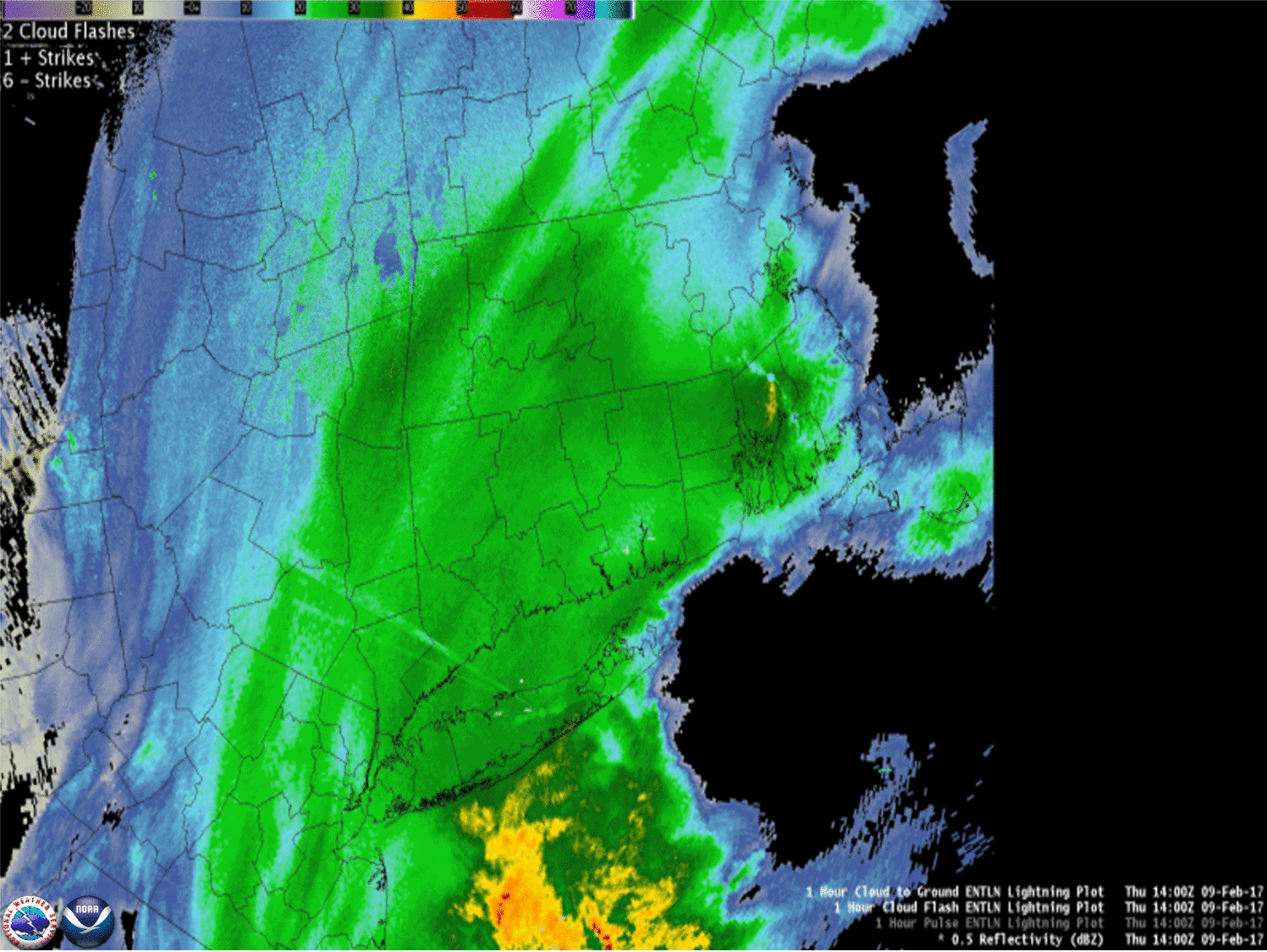 | |
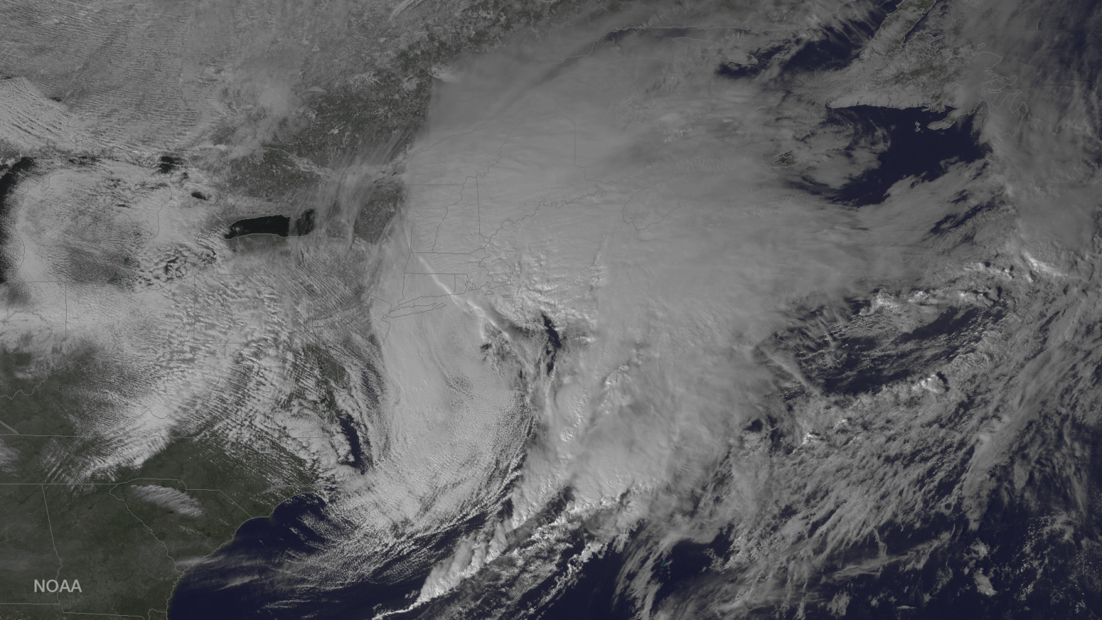
| Regional radar mosaic from 3 am until 7 pm | Hourly regional radar Mosaic starting 9 am until 3 pm including Earth Networks Total Lightning. + or - a cloud to ground and . are in cloud flashes |
 |
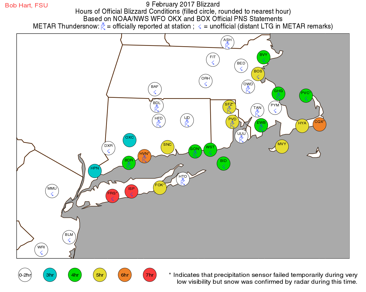 |
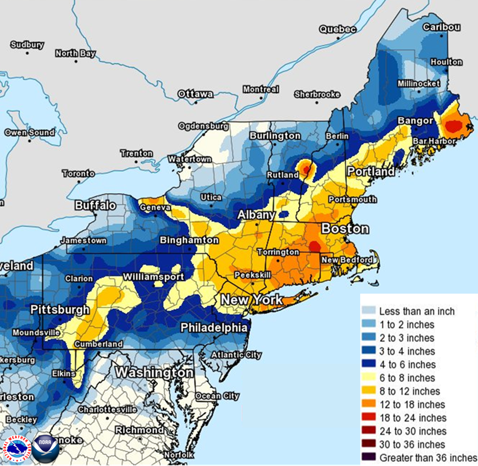
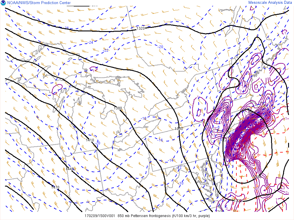
...SUMMARY OF THE BLIZZARD OF FEBRUARY 9 2017...

THE INFORMATION IN THIS STATEMENT IS PRELIMINARY AND SUBJECT TO
FURTHER VERIFICATION BY THE NATIONAL WEATHER SERVICE.

A BLIZZARD OCCURRED OVER PORTIONS OF LONG ISLAND...SOUTHERN
CONNECTICUT AND COASTAL PORTIONS OF THE LOWER HUDSON VALLEY ON
FEBRUARY 9 2017...FROM AFTER SUNRISE INTO THE LATE AFTERNOON HOURS.

THE DEFINITION OF A BLIZZARD:
 - SUSTAINED WINDS OR FREQUENT GUSTS GREATER THAN OR EQUAL TO 35
   MPH
 - CONSIDERABLE FALLING AND/OR BLOWING SNOW
 - VISIBILITY FREQUENTLY REDUCED TO LESS THAN 1/4 OR MILE
 - OCCURS FOR THREE HOURS OR MORE

WHEN REVIEWING WHETHER A PARTICULAR OBSERVATION LOCATION HAD
BLIZZARD CONDITIONS...VISIBILITIES EQUAL TO 1/4 MILE WERE
COUNTED. THIS IS BECAUSE THESE ARE QUITE LOW FOR AN AUTOMATED
VISIBILITY SENSOR TO DETECT.

AT LONG ISLAND MACARTHUR AIRPORT (ISLIP NY)...BLIZZARD CRITERIA
WAS MET FOR 7 HOURS AMD 23 MINUTES...FROM 822 AM TO 218 PM AND
FROM 256 PM TO 423 PM.

AT CHESTER AIRPORT (CHESTER CT)...BLIZZARD CRITERIA WAS MET FOR 4
HOURS AND 40 MINUTES FROM 1015 AM TO 255 PM.

AT IGOR I SIKORSKY MEMORIAL AIRPORT (BRIDGEPORT CT)...BLIZZARD
CRITERIA WAS MET FOR 4 HOURS 21 MINUTES...FROM 852 AM TO 113 PM.

AT WATERBURY-OXFORD AIRPORT (OXFORD CT)...BLIZZARD CONDITIONS WAS
MET FOR 3 HOURS FROM 850 AM TO 1050 AM AND FROM 1250 PM TO 150
PM.

AT WEST CHESTER COUNTY AIRPORT (WHITE PLAINS NY)...BLIZZARD
CONDITIONS WERE MET FOR 3 HOURS...FROM 9:56 AM TO 1256 PM.

IT ALSO WAS DETERMINED THAT A BLIZZARD ALSO OCCURRED AT
FARMINGDALE NY...NEW HAVEN CT...WESTHAMPTON BEACH NY AND GROTON
CT.

AT REPUBLIC AIRPORT (FARMINGDALE NY)...BLIZZARD CRITERIA WAS MET
FOR 6 HOURS AND 38 MINUTES FROM 733 AM TO 211 PM. THE PRESENT
WEATHER SENSOR FAILED AT 915 AM (SNOW VERIFIED BY RADAR).

AT TWEED NEW HAVEN AIRPORT (NEW HAVEN CT)...BLIZZARD CRITERIA WAS
MET FOR 5 HOURS 36 MINUTES FROM 853 AM TO 129 PM. THE PRESENT
WEATHER SENSOR FAILED FROM 1137 AM TO 1228 PM (SNOW VERIFIED BY
RADAR).

AT FRANCIS S GABRESKI AIRPORT (WESTHAMPTON BEACH NY)...BLIZZARD
CRITERIA WAS MET FOR 5 HOURS AND 29 MINUTES FROM 953 AM TO 244 PM
AND FROM 317 PM TO 353 PM. THE PRESENT WEATHER SENSOR DID NOT
OPERATE DURING THIS TIME FRAME (SNOW VERIFIED BY RADAR).

AT GROTON-NEW LONDON AIRPORT (GROTON CT)...BLIZZARD CRITERIA WAS
MET FOR 4 HOURS AND 23 MINUTES FROM 1030 AM TO 253 PM. THE PRESENT
WEATHER SENSOR FAILED AT 1044 AM (SNOW VERIFIED BY RADAR).

IT IS POSSIBLE THAT BLIZZARD CONDITIONS ALSO OCCURRED AT EAST
HAMPTON NY...BUT FAILURE OF THE VISIBILITY...WIND AND PRESENT
WEATHER SENSORS DURING THE EVENT REQUIRE ADDITIONAL INFORMATION
TO VERIFY.

ELSEWHERE ACROSS THE TRI-STATE...NEAR BLIZZARD CONDITIONS OCCURRED
AT SOUTH OZONE PARK NY...EAST ELMHURST NY...NEWARK NJ...
TETERBORO NJ AND MERIDEN CT. AT SOUTH OZONE PARK NEW YORK (JOHN F
KENNEDY INTERNATIONAL AIRPORT) BLIZZARD CONDITIONS OCCURRED FOR
37 MINUTES...OTHERWISE GUSTS WERE SUFFICIENT...BUT VISIBILITIES
WERE FREQUENTLY AROUND 1/2 MILE. AT EAST ELMHURST NY (LA GUARDIA
AIRPORT)...NEWARK NJ (NEWARK LIBERTY INTERNATIONAL AIRPORT)...
TETERBORO NJ (TETERBORO AIRPORT) AND MERIDEN CT (MERIDEN MARKHAM
MUNICIPAL AIRPORT) VISIBILITIES WERE SUFFICIENTLY LOW...BUT
FREQUENT GUSTS WERE BELOW 35 MPH DURING THE TIME VISIBILITIES
WERE LOW.
|
National Weather Service WFO New York, NY Watches, Warnings, and Advisories
The following links show each Blizzard Watch, Blizzard Warning, Winter Storm Watch, Winter Storm Warning, and Special Weather Statements issued during this winter storm. The Winter Strom Watch was issued at 3:22 pm Tuesday, February 7, 2017. The Winter Storm Warning was issued at 3:42 am Wednesday, February 8, 2017. First Blizzard Warnings were issued at 3:17 pm Wednesday, February 8, 2017.
Climate/Past Weather
Local Past Weather
Recent and Past Rainfall
Local Normals, Extremes and Records
Tropical Cyclone Reports
Current Conditions
Observations (List)
Observations (Map)
Marine Obs (Map)
Local Storm Report
Public Information Statement
Office Programs
Air Quality
Aviation Weather
Coastal Flooding
Co-op Observers
Fire Weather
Heat
Hydrology/Freshwater Flooding
Marine Weather
Outreach
Severe Weather
SKYWARN
Tropical Weather
Tsunami
Winter Weather
Upper Air
Weather Safety/Preparedness
Weather Ready Nation
Storm Ready
NOAA Weather Radio
Pubs/Brochures/Booklets
More Safety Links
US Dept of Commerce
National Oceanic and Atmospheric Administration
National Weather Service
New York, NY
175 Brookhaven Avenue
Upton, NY 11973
631-924-0517
Comments? Questions? Please Contact Us.
Thank you for visiting a National Oceanic and Atmospheric Administration (NOAA) website. The link you have selected will take you to a non-U.S. Government website for additional information.
NOAA is not responsible for the content of any linked website not operated by NOAA. This link is provided solely for your information and convenience, and does not imply any endorsement by NOAA or the U.S. Department of Commerce of the linked website or any information, products, or services contained therein.
You will be redirected to:


 Coastal Flooding