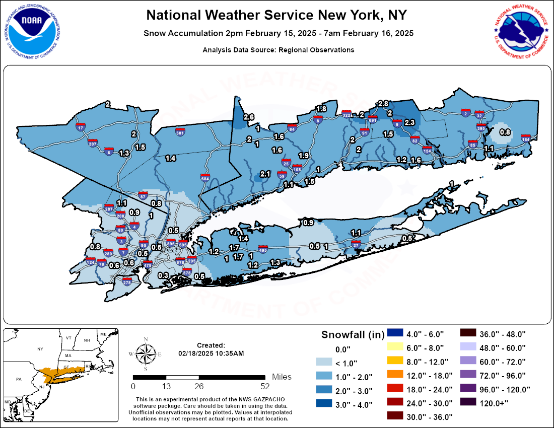
Observed Snowfall Analysis
Snow Reports Public Information Statement
(The link above is courtesy of the Iowa State University State Mesonet (IEM) National Weather Service Text Product Archive)
Snowfall Reports By State
| Connecticut |
  Location                    Amount    Time/Date      Provider

...Fairfield County...
4 NNW New Fairfield          2.6 in    1100 PM 02/15   Trained Spotter
2 SSW Weston                 2.1 in    0930 PM 02/15   Trained Spotter
1 ESE Danbury                2.0 in    1000 PM 02/15   Trained Spotter
3 WSW Shelton                1.9 in    1030 PM 02/15   Trained Spotter
5 ENE Redding                1.6 in    0945 PM 02/15   Trained Spotter
1 ENE Newtown                1.6 in    0943 PM 02/15   Public
Bridgeport Airport           1.5 in    0700 AM 02/16   Official NWS Obs
2 ENE Fairfield              1.1 in    0836 PM 02/15   Public
3 ENE New Fairfield          1.0 in    0924 PM 02/15   Public
Bethel                       1.0 in    0700 AM 02/16   Official NWS Obs

...Middlesex County...
4 W Cromwell                 2.8 in    0945 PM 02/15   Public
Higganum                     2.3 in    1045 PM 02/15   Public
Middletown                   2.0 in    0800 AM 02/16   Trained Spotter
Clinton                      1.6 in    1030 PM 02/15   Broadcast Media
Durham                       1.5 in    0800 AM 02/16   Trained Spotter

...New Haven County...
1 NNW North Haven            2.0 in    1030 PM 02/15   Trained Spotter
1 ENE North Haven            2.0 in    1045 PM 02/15   Trained Spotter
Meriden                      2.0 in    0800 AM 02/16   Trained Spotter
2 NW Waterbury               1.8 in    0915 PM 02/15   Trained Spotter
Madison                      1.2 in    0928 PM 02/15   Public
Milford                      1.0 in    0800 AM 02/16   Trained Spotter

...New London County...
Groton                       1.5 in    1011 PM 02/15   Public
New London                   1.1 in    1030 PM 02/15   Trained Spotter
2 SSE Ledyard Center         0.8 in    0600 PM 02/15   Trained Spotter
|
| New Jersey |
Location Amount Time/Date Provider ...Bergen County... 2 NNE Franklin Lakes 1.1 in 0930 PM 02/15 Trained Spotter 1 ESE Westwood 1.0 in 0700 PM 02/15 Trained Spotter Waldwick 0.9 in 0703 PM 02/15 Public 1 N River Vale 0.8 in 0630 PM 02/15 Trained Spotter ...Essex County... West Orange 1.0 in 0600 PM 02/15 Public 1 E Livingston 0.8 in 0616 PM 02/15 Public ...Hudson County... Harrison 0.6 in 0700 PM 02/15 CO-OP Observer Hoboken 0.5 in 0615 PM 02/15 Trained Spotter ...Union County... Newark Airport 0.6 in 0700 AM 02/16 Official NWS Obs |
| New York |
Location Amount Time/Date Provider ...Bronx County... 1 NW Fordham 0.5 in 0608 PM 02/15 Public ...Kings County... Midwood 0.3 in 0530 PM 02/15 Broadcast Media ...Nassau County... 1 WSW Plainview 1.7 in 0615 PM 02/15 Public 1 SSE Plainview 1.7 in 0617 PM 02/15 Public 1 N Syosset 1.4 in 0600 PM 02/15 Trained Spotter 2 SE Plainedge 1.2 in 0718 PM 02/15 Public Manhasset Hills 1.2 in 0621 PM 02/15 Public Farmingdale 1.0 in 0545 PM 02/15 Public East Meadow 1.0 in 0545 PM 02/15 NWS Employee ...New York (Manhattan) County... Central Park 0.5 in 0700 AM 02/16 Official NWS Obs ...Orange County... Salisbury Mills 2.0 in 0700 PM 02/15 Trained Spotter 2 ESE Pine Bush 2.0 in 0915 PM 02/15 Public 2 E Highland Mills 1.5 in 0900 PM 02/15 Public Monroe 1.3 in 0500 AM 02/16 Trained Spotter ...Queens County... NYC/La Guardia 0.6 in 0700 AM 02/16 Official NWS Obs NYC/JFK 0.5 in 0700 PM 02/15 Official NWS Obs ...Suffolk County... Babylon 1.3 in 0641 PM 02/15 Public Upton (NWS Office) 1.1 in 0700 PM 02/15 Official NWS Obs Orient 1.0 in 0941 PM 02/15 CO-OP Observer North Patchogue 1.0 in 0745 PM 02/15 Public 1 NNW Stony Brook 0.9 in 0615 PM 02/15 NWS Employee Islip Airport 0.5 in 0700 AM 02/16 Official NWS Obs ...Westchester County... Peekskill 1.4 in 1159 PM 02/15 Trained Spotter |
Observed Freezing Rain Analysis
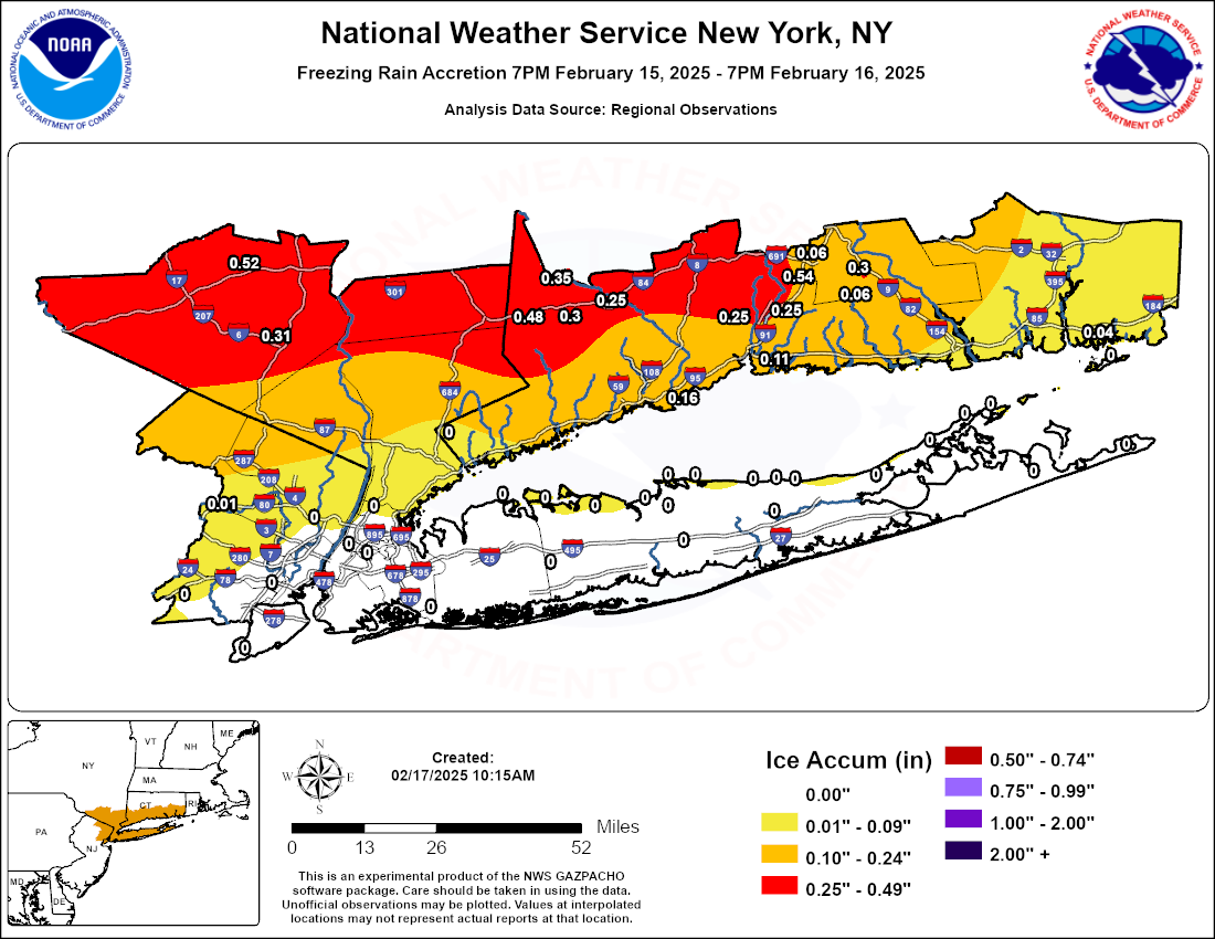
Freezing Rain Reports By State
| Connecticut |
  Location                    Amount    Time/Date      Provider

...Fairfield County...
Danbury Airport              0.48 in   0115 PM 02/16   ASOS
New Fairfield                0.35 in   0900 AM 02/16   Trained Spotter
Bethel                       0.30 in   0700 AM 02/16   Cocorahs
Newtown                      0.25 in   1100 AM 02/16   Trained Spotter
Bridgeport Airport           0.16 in   1100 AM 02/16   ASOS

...Middlesex County...
3 W Higganum                 0.30 in   0700 AM 02/16   Utility Company
Durham                       0.06 in   0800 AM 02/16   Trained Spotter

...New Haven County...
Meriden Airport              0.54 in   1211 PM 02/16   ASOS
North Haven                  0.25 in   0815 AM 02/16   Trained Spotter
1 NNW Meriden                0.25 in   0306 AM 02/16   Public
Hamden                       0.25 in   0920 AM 02/16   Broadcast Media
New Haven Airport            0.11 in   1100 AM 02/16   ASOS
Meriden                      0.06 in   0800 AM 02/16   Trained Spotter

...New London County...
Groton Airport               0.04 in   0732 AM 02/16   ASOS
|
| New Jersey |
Location Amount Time/Date Provider ...Essex County... Caldwell 0.01 in 0613 AM 02/16 ASOS |
| New York |
Location Amount Time/Date Provider ...New York (Manhattan) County... Central Park T in 0351 AM 02/16 ASOS ...Orange County... Montgomery Airport 0.52 in 0119 PM 02/16 AWOS Monroe 0.31 in 0500 AM 02/16 Trained Spotter |
Peak Wind Gusts Analysis
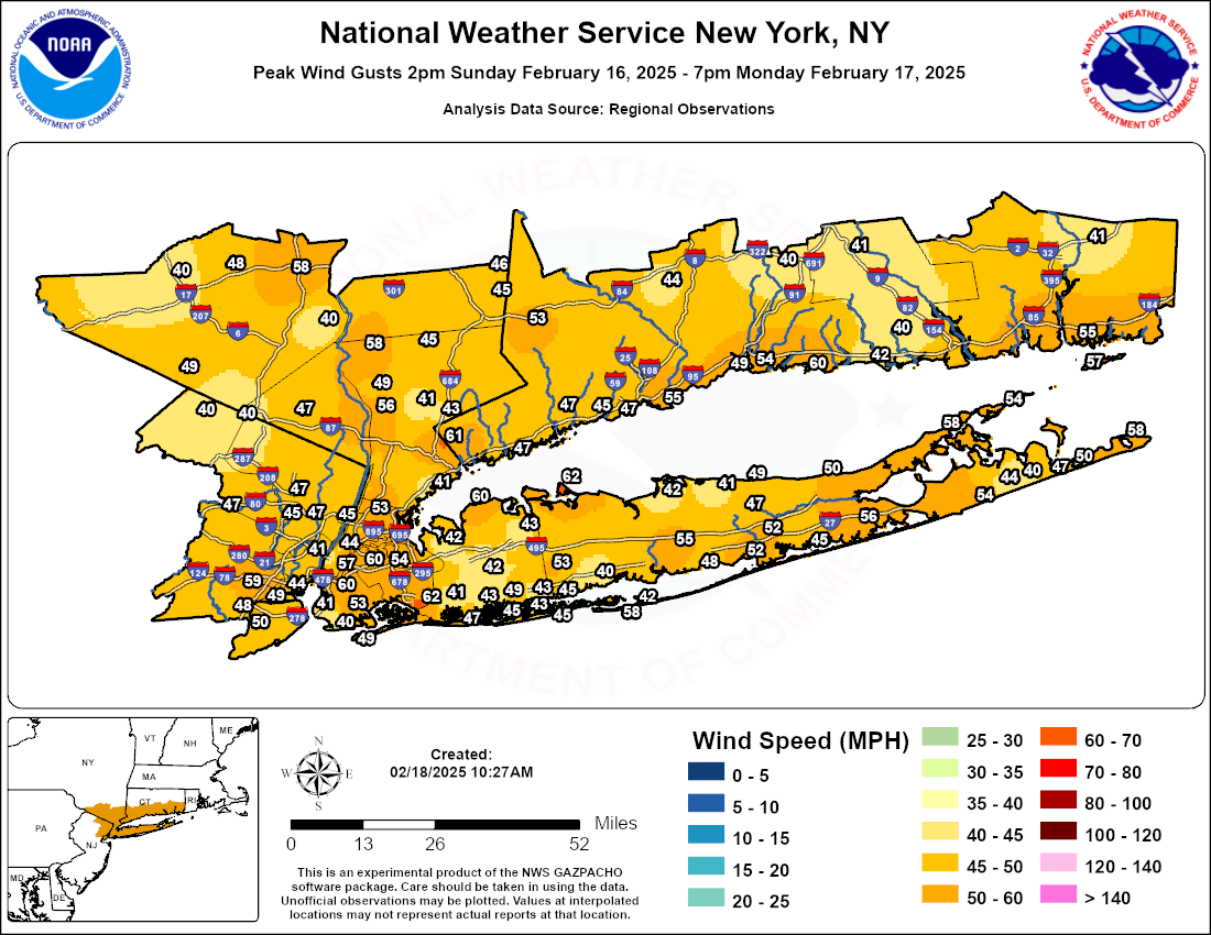
Peak Wind Gusts Public Information Statement
(The link above is courtesy of the Iowa State University State Mesonet (IEM) National Weather Service Text Product Archive)
Wind Gust Reports By State
| Connecticut |
  Location                    Amount    Time/Date      Provider

...Fairfield County...
Bridgeport Airport           55 MPH    0911 PM 02/16   ASOS
Danbury Airport              53 MPH    0952 AM 02/17   ASOS
Fairfield                    47 MPH    1245 PM 02/17   CWOP
Norwalk                      47 MPH    0635 AM 02/17   CWOP
STAMFORD                     47 MPH    0930 PM 02/16   CWOP
Fairfield                    45 MPH    0236 AM 02/17   CWOP

...Middlesex County...
Middletown - Rt9nb - On Ramp 41 MPH    0650 AM 02/17   MESOWEST
Chester Airport              40 MPH    0835 AM 02/17   AWOS

...New Haven County...
Stony Creek                  60 MPH    0823 AM 02/17   CWOP
New Haven Airport            54 MPH    0848 AM 02/17   ASOS
Lighthouse Point             49 MPH    0259 AM 02/17   WXFLOW
Waterbury Airport            44 MPH    0619 AM 02/17   AWOS
Hammonasset                  42 MPH    0858 AM 02/17   WXFLOW
Meriden Airport              40 MPH    0854 AM 02/17   ASOS

...New London County...
Groton Airport               55 MPH    0903 AM 02/17   ASOS
Lisbon                       41 MPH    1130 AM 02/17   CWOP

...Maritime Stations...
1 ESE Norwalk                63 MPH    0657 AM 02/17   WXFLOW
Stongington Outer Breakwater 52 MPH    0943 AM 02/17   WXFLOW
USCG Academy                 45 MPH    1033 AM 02/17   WXFLOW
|
| New Jersey |
  Location                    Amount    Time/Date      Provider

...Bergen County...
Fair Lawn                    47 MPH    0710 PM 02/16   CWOP
Teterboro Airport            47 MPH    1049 AM 02/17   ASOS
Hasbrouck Heights            45 MPH    0754 AM 02/17   CWOP

...Essex County...
Caldwell                     47 MPH    0503 AM 02/17   ASOS

...Hudson County...
Bayonne                      44 MPH    0935 AM 02/17   WXFLOW

...Passaic County...
Ringwood                     40 MPH    1010 PM 02/16   RAWS
3 ENE West Milford           40 MPH    0139 PM 02/17   AWOS

...Union County...
Newark Airport               59 MPH    1003 AM 02/17   ASOS
Linden Airport               48 MPH    0615 AM 02/17   AWOS

...Maritime Stations...
Jersey City                  44 MPH    0623 PM 02/16   CWOP
|
| New York |
Location Amount Time/Date Provider ...Bronx County... Fordham 53 MPH 1030 AM 02/17 NYSM ...Kings County... South Slope 60 MPH 1219 AM 02/17 CWOP Brooklyn College 53 MPH 0905 AM 02/17 NYSM Dyker Heights 41 MPH 0615 AM 02/17 CWOP BROOKLYN 40 MPH 0957 PM 02/16 CWOP ...Nassau County... Bayville 60 MPH 1052 AM 02/17 WXFLOW Wantagh 49 MPH 0825 AM 02/17 NYSM 1 ESE Long Beach 47 MPH 0630 PM 02/16 AWS Bellmore 45 MPH 0901 AM 02/17 CWOP MASSAPEQUA 43 MPH 0949 AM 02/17 CWOP Massapequa Park 43 MPH 0645 PM 02/16 CWOP Merrick 43 MPH 1050 AM 02/17 CWOP Syosset 43 MPH 0630 AM 02/17 CWOP Manhasset 42 MPH 0925 AM 02/17 DAVIS 1.2 NW Uniondale (WEATHERSTE 42 MPH 0910 AM 02/17 MESOWEST Valley Stream 41 MPH 0731 AM 02/17 CWOP ...New York (Manhattan) County... Midtown Manhattan 57 MPH 1020 AM 02/17 NYSM Washington Heights 45 MPH 1110 AM 02/17 AWS Central Park 44 MPH 1010 AM 02/17 ASOS New York 41 MPH 0955 AM 02/17 DAVIS ...Orange County... Stewart Airport 58 MPH 0845 PM 02/16 AWOS Warwick 49 MPH 0850 PM 02/16 NYSM Montgomery Airport 48 MPH 1016 AM 02/17 AWOS Middletown 40 MPH 1135 AM 02/17 DAVIS US Military Academy 40 MPH 0955 AM 02/17 RAWS ...Putnam County... Patterson 46 MPH 0955 PM 02/16 DAVIS Brewster 45 MPH 0705 AM 02/17 NYSM ...Queens County... NYC/JFK Airport 62 MPH 0637 PM 02/16 ASOS NYC/La Guardia 60 MPH 0633 AM 02/17 ASOS Kew Garden Hills 54 MPH 0715 AM 02/17 NYSM Breezy Point 49 MPH 0724 AM 02/17 WXFLOW ...Richmond County... College of Staten Island 50 MPH 0950 PM 02/16 NYSM 2 SE Elizabeth 49 MPH 0200 AM 02/17 NDBC ...Rockland County... Suffern 47 MPH 1040 AM 02/17 NYSM ...Suffolk County... Eatons Neck 62 MPH 0149 AM 02/17 WXFLOW FAIR HARBOR 58 MPH 0649 AM 02/17 CWOP Montauk Airport 58 MPH 0345 AM 02/17 ASOS Southold 58 MPH 0935 AM 02/17 CWOP Fishers Island Airport 57 MPH 0643 AM 02/17 WXFLOW Westhampton Airport 56 MPH 1206 PM 02/17 ASOS Islip Airport 55 MPH 1013 AM 02/17 ASOS Mecox Bay 54 MPH 0813 AM 02/17 WXFLOW Orient 54 MPH 0905 AM 02/17 CWOP Farmingdale Airport 53 MPH 0729 AM 02/17 ASOS Brookhaven 52 MPH 0230 PM 02/16 CWOP Shirley Airport 52 MPH 0250 AM 02/17 ASOS Baiting Hollow 50 MPH 0635 AM 02/17 CWOP Napeague 50 MPH 0807 AM 02/17 WXFLOW Shoreham 49 MPH 0930 AM 02/17 DAVIS Blue Point 48 MPH 0706 AM 02/17 WXFLOW Amagansett 47 MPH 0955 AM 02/17 DAVIS Ridge 47 MPH 1140 AM 02/17 CWOP East Moriches CG 45 MPH 0307 AM 02/17 WXFLOW Great South Bay 45 MPH 1001 PM 02/16 WXFLOW West Gilgo Beach 45 MPH 0615 AM 02/17 CWOP 1 E East Hampton Airport 44 MPH 0855 AM 02/17 AWOS Saltaire 42 MPH 0435 AM 02/17 DAVIS Stony Brook 42 MPH 0745 AM 02/17 NYSM Miller Place 41 MPH 1145 AM 02/17 CWOP East Hampton 40 MPH 1105 AM 02/17 CWOP West Islip 40 MPH 0844 AM 02/17 CWOP ...Westchester County... White Plains Airport 61 MPH 0710 AM 02/17 ASOS Peekskill 58 MPH 1025 AM 02/17 DAVIS Tappan Zee Light 14 56 MPH 1024 AM 02/17 WXFLOW Croton 49 MPH 0104 AM 02/17 WXFLOW Somers 45 MPH 0625 AM 02/17 NYSM Armonk 43 MPH 0728 AM 02/17 CWOP Mamaroneck 41 MPH 0555 AM 02/17 DAVIS Robert E. Bell Middle School 41 MPH 0100 PM 02/17 MESOWEST ...Maritime Stations... Robbins Reef, NJ 60 MPH 0912 AM 02/17 NOS-PORTS Shinnecock 57 MPH 0800 AM 02/17 WXFLOW Fire Island CG 54 MPH 1039 AM 02/17 WXFLOW Point O Woods YC 51 MPH 0812 AM 02/17 WXFLOW City Island 50 MPH 0900 AM 02/17 CWOP Kings Point 49 MPH 0730 AM 02/17 NOS-NWLON Northport 49 MPH 1015 AM 02/17 DAVIS Larchmont Harbor 48 MPH 0825 AM 02/17 WXFLOW |

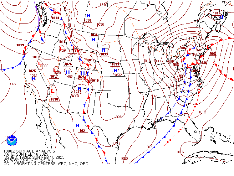
Surface Analysis
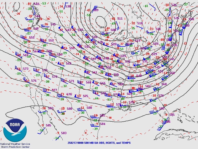
500 mb Analysis


 Coastal Flooding