Overview
|
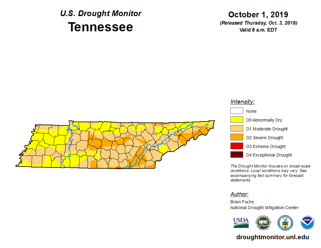
An unusually persistent upper level ridge of high pressure centered near and over the Tennessee Valley caused a prolonged period of record to near-record heat and dry weather throughout Middle Tennessee from September 2019 into early October 2019. This heatwave set new records for warmest September ever at Crossville and second warmest September ever at Nashville, as well as the hottest temperatures ever observed in the month of October at both locations. In addition, the lack of rainfall in both Nashville and Crossville made September 2019 the driest month of September ever since records began. Interestingly, this occurred only one year after the very wet month of September 2018, which was the #7 wettest at Nashville and the #1 wettest September ever at Crossville. In addition, although 2019 started off extremely wet with record rainfall and flooding in February and March, the lengthy dry conditions in September and October created moderate to severe drought conditions across the entire region, with several brush fires reported in late September and early October. Thankfully, much cooler and wetter weather arrived by the second week of October, ending this period of record heat and dryness. |
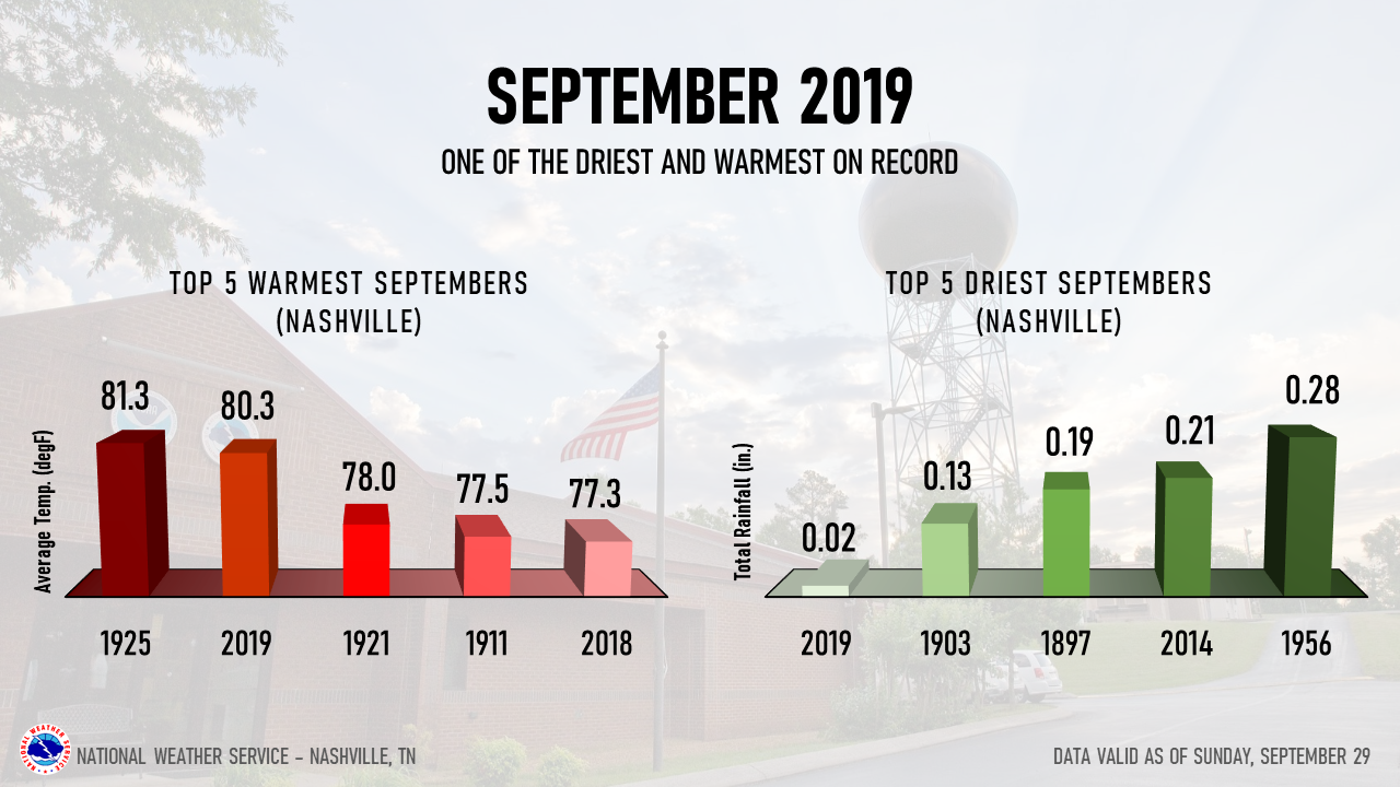 Top 5 Warmest & Driest Septembers in Nashville |
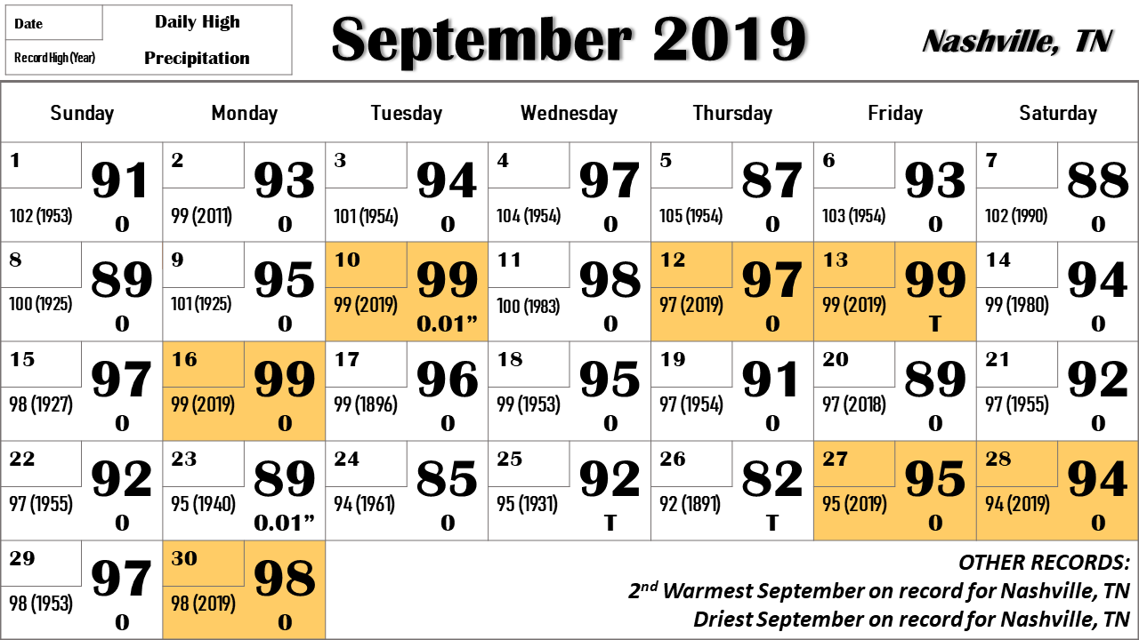
September 2019 Temperatures & Rainfall
 |
 |
|
NASHVILLE, TN |
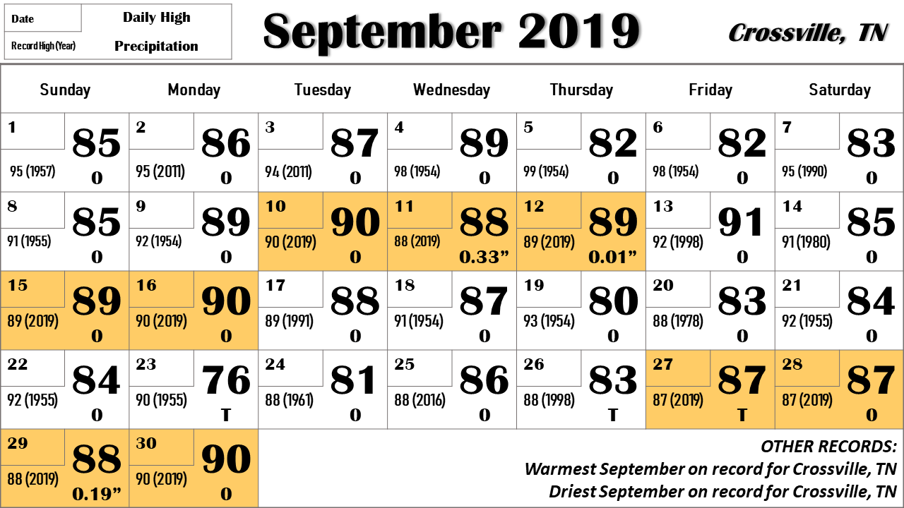
CROSSVILLE, TN |
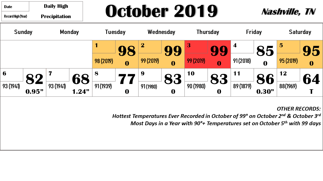
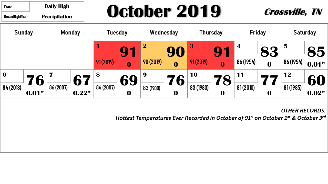
October 2019 Temperatures & Rainfall
 |
 |
|
NASHVILLE, TN |
CROSSVILLE, TN |
September 2019 Records
Public Information Statement
National Weather Service Nashville TN
232 PM CDT Tue Oct 1 2019

...September, 2019 was a record-breaking month...

September, 2019 will be known both for its heat and for a lack of
rain.

At Nashville, the average temperature for the month was 80.4
degrees, which makes last month the second-warmest September in
Nashville`s history. This is 8.9 degrees above normal. The average
high temperature was 93.2 degrees and the average low was 67.6.
The temperature peaked at 99 degrees on the 10th, 13th and 16th.
There were 23 days on which the temperature reached 90 degrees or
better, which is a record. Individual record highs were tied or
set on the 10th, 12th, 13th, 16th, 27th, 28th and 30th.

The lowest temperature was 57 degrees, which occurred on the 25th.
Every day of the month was above normal.

In addition to the heat, September, 2019 ranks as the driest
September ever, and the second-driest month overall in
Nashville`s history. Total rainfall for the month was just 0.02
inches. Normal rainfall for September is 3.41 inches.

Crossville experienced its warmest September ever. The average
temperature was 73.3 degrees, which was 6.1 degrees above normal.
The average high temperature was 85.8 degrees and the average low
was 60.9. Individual record highs were tied or broken on the 10th
through 12th, the 15th and 16th, and the 27th through 30th. The
highest temperature was 91 degrees on the 13th, and the lowest
temperature was 49 degrees on the 25th.

Total rainfall for the month was 0.53 inches, making this the
driest September in Crossville`s history. Normal rainfall for
September is 3.88 inches.

Clarksville likewise finished the month with an average
temperature of 77.0 degrees, which was 6.9 degrees above normal.
There were 20 days of 90 degrees or better. The average high
temperature was 90.8 degrees and the average low was 63.2. The
highest temperature was 96 degrees, which occurred on the 10th and
again on the 16th. The lowest temperature was 54 degrees on the
24th and 25th.

Rainfall for the month totaled 0.31 inches. Normal rainfall for
September is 3.53 inches.

$$

Rose
October 2019 Records
RECORD EVENT REPORT
NATIONAL WEATHER SERVICE NASHVILLE TN
418 PM CDT TUE OCT 01 2019

...RECORD HIGH TEMPERATURE SET AT NASHVILLE...

A RECORD HIGH TEMPERATURE OF 98 DEGREES WAS SET AT NASHVILLE TODAY.
THIS BREAKS THE OLD RECORD OF 94 SET IN 1953.

$$

RECORD EVENT REPORT
NATIONAL WEATHER SERVICE NASHVILLE TN
418 PM CDT TUE OCT 01 2019

...RECORD HIGH TEMPERATURE SET AT CROSSVILLE...

A RECORD HIGH TEMPERATURE OF 91 DEGREES WAS SET AT CROSSVILLE TODAY.
THIS BREAKS THE OLD RECORD OF 84 SET IN 1956.

$$

RECORD EVENT REPORT
NATIONAL WEATHER SERVICE NASHVILLE TN
421 PM CDT TUE OCT 01 2019

...OCTOBER MONTHLY RECORD HIGH TEMPERATURE SET AT NASHVILLE...

THE OCTOBER MONTHLY RECORD HIGH TEMPERATURE OF 98 DEGREES WAS SET AT
NASHVILLE TODAY. THIS BREAKS THE OLD OCTOBER MONTHLY RECORD OF 94
SET ON OCTOBER 1 1953.

$$

SHAMBURGER

RECORD EVENT REPORT
NATIONAL WEATHER SERVICE NASHVILLE TN
421 PM CDT TUE OCT 01 2019

...OCTOBER MONTHLY RECORD HIGH TEMPERATURE SET AT CROSSVILLE...

THE OCTOBER MONTHLY RECORD HIGH TEMPERATURE OF 91 DEGREES WAS SET AT
CROSSVILLE TODAY. THIS BREAKS THE OLD OCTOBER MONTHLY RECORD OF 86
LAST SET ON OCTOBER 7 2007.

$$

SHAMBURGER

___________________________________________________________________

RECORD EVENT REPORT
NATIONAL WEATHER SERVICE NASHVILLE TN
415 PM CDT WED OCT 02 2019

...RECORD HIGH TEMPERATURE SET AT NASHVILLE...

A RECORD HIGH TEMPERATURE OF 99 DEGREES WAS SET AT NASHVILLE TODAY.
THIS BREAKS THE OLD RECORD OF 91 SET IN 1953.

$$

SHAMBURGER

RECORD EVENT REPORT
NATIONAL WEATHER SERVICE NASHVILLE TN
415 PM CDT WED OCT 02 2019

...RECORD HIGH TEMPERATURE SET AT CROSSVILLE...

A RECORD HIGH TEMPERATURE OF 90 DEGREES WAS SET AT CROSSVILLE TODAY.
THIS BREAKS THE OLD RECORD OF 86 SET IN 1986.

$$

SHAMBURGER

RECORD EVENT REPORT
NATIONAL WEATHER SERVICE NASHVILLE TN
417 PM CDT WED OCT 02 2019

...NEW OCTOBER MONTHLY RECORD HIGH TEMPERATURE SET AT NASHVILLE...

A NEW OCTOBER MONTHLY RECORD HIGH TEMPERATURE OF 99 DEGREES WAS SET
AT NASHVILLE TODAY. THIS BREAKS THE OLD OCTOBER MONTHLY RECORD OF 98
SET YESTERDAY ON OCTOBER 1 2019.

$$

SHAMBURGER

___________________________________________________________________

RECORD EVENT REPORT
NATIONAL WEATHER SERVICE NASHVILLE TN
410 PM CDT THU OCT 03 2019

...RECORD HIGH TEMPERATURE SET AT NASHVILLE...

A RECORD HIGH TEMPERATURE OF 99 DEGREES WAS SET AT NASHVILLE TODAY.
THIS BREAKS THE OLD RECORD OF 92 SET IN 1903.

$$

SHAMBURGER

RECORD EVENT REPORT
NATIONAL WEATHER SERVICE NASHVILLE TN
410 PM CDT THU OCT 03 2019

...RECORD HIGH TEMPERATURE SET AT CROSSVILLE...

A RECORD HIGH TEMPERATURE OF 91 DEGREES WAS SET AT CROSSVILLE TODAY.
THIS BREAKS THE OLD RECORD OF 84 SET IN 1986.

$$

SHAMBURGER

RECORD EVENT REPORT...CORRECTED
NATIONAL WEATHER SERVICE NASHVILLE TN
414 PM CDT THU OCT 03 2019

...OCTOBER MONTHLY RECORD HIGH TEMPERATURE TIED AT NASHVILLE...

THE OCTOBER MONTHLY RECORD HIGH TEMPERATURE OF 99 DEGREES WAS TIED
AT NASHVILLE TODAY. THIS TIES THE OCTOBER MONTHLY RECORD OF 99 SET
JUST YESTERDAY ON OCTOBER 2 2019.

$$

SHAMBURGER

RECORD EVENT REPORT
NATIONAL WEATHER SERVICE NASHVILLE TN
414 PM CDT THU OCT 03 2019

...OCTOBER MONTHLY RECORD HIGH TEMPERATURE TIED AT CROSSVILLE...

THE OCTOBER MONTHLY RECORD HIGH TEMPERATURE OF 91 DEGREES WAS TIED
AT CROSSVILLE TODAY. THIS TIED THE OCTOBER MONTHLY RECORD OF 91
SET TWO DAYS AGO ON OCTOBER 1 2019.

$$

SHAMBURGER

___________________________________________________________________

RECORD EVENT REPORT
NATIONAL WEATHER SERVICE NASHVILLE TN
518 PM CDT SAT OCT 05 2019

...UPDATED RECORD HIGH TEMPERATURE SET AT NASHVILLE...

A RECORD HIGH TEMPERATURE OF 95 DEGREES WAS SET AT NASHVILLE TODAY.
THIS BREAKS THE OLD RECORD OF 92 SET IN 2018.

$$

SHAMBURGER
Drought Monitor on October 1, 2019
 |
 |
Media use of NWS Web News Stories is encouraged! Please acknowledge the NWS as the source of any news information accessed from this site. |
|

