Bobby Boyd
Meteorologist
National Weather Service
Nashville, Tennessee
January 6, 2000
(Additional photographs and appendices added by Mark A. Rose)
Weather Service Established within the Army
On February 9, 1870 President Ulysses S. Grant signed into law a resolution1 requiring the Secretary of War to provide meteorological observations at military stations and other states and territories. This agency was called the Division of Telegrams and Reports for the Benefit of Commerce. The new agency operated under the Signal Service from 1870 to 1891.
Nashville Office among the First Established
The Nashville office2 was established by the U.S. Army Signal Corp Sergeant George H. Witmer on October 20, 1870 at 70½ Cherry Street (between Church Street and Union Street). The first weather report was sent on the morning of November 1, 1870. Nashville was one of twenty-four newly established locations to take and transmit weather observations via telegraph. The office had a wind vane, anemometer, and rain gage well exposed on the roof of the building. The instrument shelter projected from a window, which was not unusual in those days.
Sergeant Witmer's stay was short-lived as he was relieved on account of drunkenness January 31, 1871, and was succeeded by Sergeant W. Moore, who was relieved for the same cause on February 10, 1871 by Sergeant Thomas L. Watson, who remained in charge of the station until August 4, 1871, when he was relieved for failing to transmit his mail reports promptly. Sergeant J.H. Gerrard was placed in charge and assisted by newly assigned Private William Henderson, who was sent to the station on July 6, 1871.
Office Moved Several Times
The Nashville weather office moved several times while under the Army Signal Service, but remained in the same general area of the Nashville business district. The first move came on March 1, 1871 to 30 North College Street (3rd Avenue between Church Street and Union Street) where it would remain until moved again on August 1, 1882 to the Southwest corner of the Public Square and Market Street (2nd Avenue, 4th floor, Burns Block Building). The office remained at this location until July 1, 1889, when it moved to the roof of the Vanderbilt Building at 311-313 North Cherry Street (West side of 4th Avenue between Union Street and Deadrick Street).
Agency Transferred to the Department of Agriculture
and
U.S. Weather Bureau Created
On October 1, 1890, at the request of President Benjamin Harrison, Congress created the U.S. Weather Bureau within the Department of Agriculture. The actual transfer of weather stations, telegraph lines, apparatus, and personnel did not take place until July 1, 1891.
At the time of the transfer to the Department of Agriculture, the newly created U.S. Weather Bureau office in Nashville was located on the roof of the Vanderbilt Building and would remain there until September 1, 1894 when it was moved to the roof of the Chamber of Commerce Building at 307 Church Street. The office was moved again on June 30, 1905 to the Custom House at the corner of Broadway and 8th Avenue. Then, on March 25, 1909, the office was moved to the Stahlman Building on the 12th floor at 3rd Avenue and Union Street.
U.S. Weather Bureau Transferred to the Department of Commerce
The U.S. Weather Bureau was transferred to the Department of Commerce on June 30, 1940. The transfer from the Department of Agriculture came about in part because of the young upstart of aviation. It was only reasonable to place the Weather Bureau in the department responsible for aviation expenditures.
At the time of the transfer into the Department of Commerce the city office3 was located in the Stahlman Building at 3rd Avenue and Union Street. It would remain at this location until July 6, 1948 when it was moved to 114 9th Avenue South (on McGavock Blvd.).
Airport Office Established and Later Consolidated with City Office
The Weather Bureau Airport Station began in the Administration Building at Berry Field on June 25, 1937. Official weather observations were made at the Weather Bureau Airport Station beginning June 30, 1941. The Weather Bureau moved into the Weather Bureau Building at Berry Field on July 16, 1948. On December 15, 1950, the old city office which had been in existence since the beginning days of the Army Signal Corp was consolidated with the Weather Bureau Airport Station at Berry Field.
Surface and Upper Air Observations4 were made along with local forecasts which were provided to the public and media. Weather Bureau personnel briefed pilots on a daily basis. The office remained here until August 10, 1964 when it was moved into the Tennessee Aeronautics Commission Building at Berry Field.5 On April 1, 1970, the U.S. Weather Bureau became known as the National Weather Service. The office moved into the Government Services Building at Metropolitan Airport on June 23, 1975.6 Another move would take the office off the airport and into the GENESCO Building on September 29, 1985. This would mark the first time since 1937 that a weather office was not physically on airport property.
Weather Service Office Moves to Old Hickory Lake
On June 15, 1990 the National Weather Service Office in Nashville, which had been located in the GENESCO Building, was moved to the Shutes Branch Camp Ground on Old Hickory Lake in West Wilson County and merged with the existing Weather Service Meteorological Observatory (WSMO).7
The Weather Service Meteorological Observatory
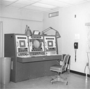
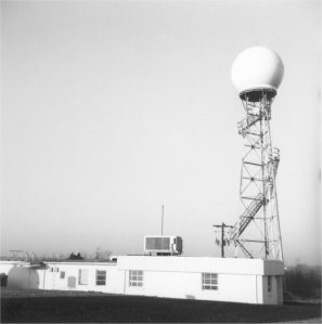
As a result of the Palm Sunday tornado outbreak of 1965, several Weather Surveilance Radars (WSR-57)8 were installed across the country with the intent of detecting tornadoes before they struck communities. During the spring and summer of 1970, a WSR-57 was installed at the upper air site on Old Hickory Lake in the Shutes Branch Camp Ground. The radar proved to be invaluable during the super tornado outbreak of April 3rd and 4th, 1974, and many severe weather events throughout its lifetime. In addition to the upper air observations, personnel had the added radar duties. In the early 1970's, the site became known as the Weather Service Meteorological Observatory (WSMO).
Nationwide restructuring and modernization program
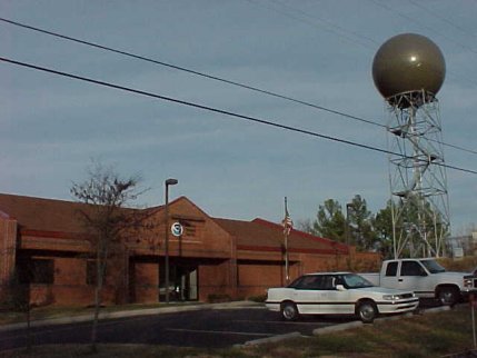
The National Weather Service is undergoing a nationwide major restructuring and modernization program that began in the mid 1980's. This program has brought about major improvements in facilities and technology to the weather service in Nashville, including a new 3.5 million dollar weather facility and Doppler radar. This modern weather facility, which opened during the late summer of 19949, utilizes state-of-the-art technology including the WSR-88D10 Doppler weather radar system11, ASOS (Automated Surface Observing System), and recently deployed AWIPS (Advanced Weather Interactive Processing System) computers12. A highly trained staff of 20 employees can now utilize this equipment to provide improved weather forecasts and warnings to Middle Tennessee and the Cumberland Plateau.
The National Weather Service Office (NWSO) in Nashville officially became a National Weather Service Forecast Office (NWSFO) on July 15, 1999 at 11:00 a.m. CDT. This marked an end to the spin-up process, at which full time forecast responsibility was officially transferred from the Memphis NWSFO.13
____________________
1 The joint resolution was introduced by Congressman Halbert E. Paine.
2 Rent paid was at the rate of $200 per annum.
3 For several years, two weather offices existed in Nashville. The old city office which was downtown and the newly created airport office.
4 Because of the use of hydrogen gas in the weather balloons, the upper air observations were moved from the airport at Berry Field to a remote location on Old Hickory Lake known as Shutes Branch Camp Ground in West Wilson County in September, 1963.
5 February 9, 1970 marked the 100th anniversary of the founding of the nation's weather service.
6 State Climatologist position abolished in 1973.
7 Surface weather observations were handed over to a private contractor on June 15, 1990. Contract surface weather observations were initially taken from the Firehall on Murfreesboro Road and later moved because of airport expansion to the Gassaway Building at 322 Knapp Blvd. on the airport March 16, 1991.
8 Developed in 1957 by the Raytheon Corporation and commissioned in November, 1970.
9 New office dedicated on September 1, 1995.
10 Developed in 1988 by the Unisys Corporation and commissioned on July 6, 1995.
11 WSR-57 decommissioned December 12, 1995.
12 AWIPS is scheduled to be commissioned on March 30, 2000.
13 Nashville assumed hydrologic responsibilities from NWSFO Memphis on July 19, 1995 and assumed aviation responsibilities from NWSFO Memphis on July 3, 1996 at 7:00 a.m. CDT.

Nashville was among the first to transmit weather reports.

Newspaper article dated August 11, 1929, when the weather station was located in the Stahlman Building.

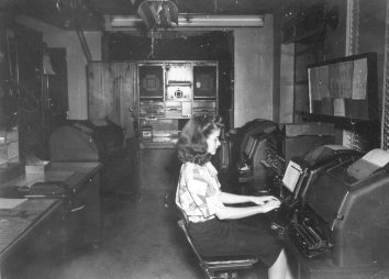
Weather Bureau Communications Office, May 21, 1947.

Rawinsonde release from Berry Field, 1947.

Administration Building, Berry Field.

Aerial photograph of the Old Hickory site in 1970. Old Hickory Lake can be seen in the upper left corner.

WSR-57 radar scope, Old Hickory, 1971.

Meteorological instrumentation.

Communications equipment.

Weather office & radar dome.

Weather balloon inflation building.

New office & WSR-88D radar dome, Old Hickory, 1997.
Appendix A.
(Following is a transcript of a memorandum written sometime after July 22, 1948. Additional information is given in brackets.)
From October 20, 1870 to March 1, 1871 the station was located in a building at 70½ Cherry Street. The thermometers were in a shelter that was attached to the north wall of the building.
From March 1, 1871 until August 1, 1882 station located at 30 North College Street [elevation 504 feet]. Wind instruments were well exposed on roof of the building, anemometer 53.8 feet above ground and wind vane 68.8 feet above ground. The shelter was projected from a window on the northeast side of building about 34 feet above ground.
From August 1, 1882 until July 1, 1889 location southwest corner of Public Square and Market Street, 4th Floor of Burns Block Building [elevation 549 feet]. Anemometer on roof 96.4 feet above ground, wind vane on roof 102.5 feet above ground. On January 1, 1886 a new shelter was erected on roof. Floor of shelter 15.3 feet above roof and 91.62 feet above ground.
From July 1, 1889 until September 1, 1894 station was located on roof of Vanderbilt Building [311-313 North Cherry Street -- elevation 553 feet]. Anemometer 14.4 feet above roof and 102.4 feet above ground, wind vane 22.1 feet above roof and 106.79 feet above ground. Shelter located 14.6 feet above roof on the southeast side of the building, elevation above ground 98.29 feet.
From September 1, 1894 until June 30, 1905 station located on roof of Chamber of Commerce Building [307 Church Street -- elevation 546 feet]. Top of rain gage was 4.0 feet above the roof and 115 feet above the ground. The instrument shelter was of standard pattern. from September 1, 1894 until April 2, 1900 the shelter was located 14.9 feet above roof. From April 2, 1900 to June 30, 1905 the shelter was mounted 9.9 feet above roof. Anemometer cups were 20.8 feet above the roof and wind vane 22.9 feet above the roof. On November 12, 1897 the elevations were changed to anemometer cups 21.2 feet above roof and 134.2 feet above ground, wind vane 19.3 feet above roof or 132.3 feet above ground.
From June 30, 1905 until March 25, 1909 the station was located on the roof, elevation 535 feet, of the Custom House at corner of 8th Avenue and Broadway. The instrument shelter was mounted 8.0 feet above the roof on the southwest corner of the building. Elevation above the ground was about 78 feet. Anemometer cups were 20.9 feet above the roof and 91.2 feet above the ground, the wind vane 18.9 feet above the roof and 89.2 feet above the ground. This was not a good exposure because the roof of the Main Building was 10 feet higher than the Weather bureau platform and the Anemometer only 10.9 feet higher than the Main Building. The rain gage was located on the Weather Bureau platform 4½ feet from anemometer pole. Top of gage was 3.4 feet above the platform and 73.7 feet above the ground.
From March 25, 1909 to June 30, 1941 the station was located in the Stahlman Building, corner of Third Avenue and Union Street, elevation 628 [627.5] feet. The instrument shelter was mounted on an iron support 10 feet high, 168 feet above the ground, located on the southwest corner of the roof. It was about 35 feet south of an open court and about 145 feet south of a large stack and exhaust pipe. With strong north winds the thermometers were slightly affected by heat from the court and stack. The wind instruments were mounted on an 18 foot pole on the roof of the penthouse. The anemometer was mounted directly over the wind vane and 191 feet above the ground. The rain gage was mounted on a tripod on the roof about midway between the court and the south side of the building.
On June 30, 1941 the station was moved to its present location at Berry Field, 6.7 miles southeast of Nashville. The anemometer was located 72.5 feet above ground on a tower in front of the Administration Building, the instrument shelter west of the Administration Building, and dry bulb thermometer 5.33 feet above ground. The rain gage was connected to the tipping bucket 3.25 feet above ground.
On January 25, 1946 the anemometer was moved to a pole on top of Administration Building. New location 57.1 feet above ground.
On January 20, 1947 the instrument shelter was moved about 50 feet to a new location south of Administration Building.
On July 16, 1948 the station was moved to the CAA Building, approximately ¼ mile north of old quarters in Administration Building, and instrument shelter relocated 50 feet east of building. On July 22, 1948 the anemometer and wind vane were relocated to roof of CAA Building; new elevation 42 feet above the ground. The 8-inch rain gage, the weighing gage and the tipping bucket rain gage were relocated to the exposure in front of the CAA Building. The 8-inch rain gage is 3.6 feet above ground, weighing rage 3.8 feet above ground and tipping bucket rain gage 3.1 feet above ground. Maximum and minimum thermometers are located in shelter 7.0 feet above the ground, psychrometer 5.4 feet above ground.
DESCRIPTION OF STATION EXPOSURE -- Country is rolling with scattered low hills in east quadrant. Quite hilly in other directions with hills rising 250 to 500 feet above general terrain about 6 miles to south and 10 miles northwest of station. There is one knob about 250 feet high 4 miles to north. No particular topographical effects. Building in which station is located is about 80 feet from a paved taxi strip with two-story building immediately to south, and one-story buildings to east and north. Flying field to west rises 7-10 feet above station, making visibility observation limited when taken from lawn immediately in front of office. Better view may be obtained from roof. Instrument shelter and raingage located on sod.
Appendix B.
(Following is a transcript of a memorandum written by Roscoe Nunn, Meteorologist, sometime between September 7, 1925 and June 30, 1941.)
From March 25, 1909, to date, the station has been in the Stahlman Building, with thermometers exposed on the roof at an elevation of 168 feet above ground.
It would be difficult to estimate the proper corrections to be applied to the thermometer readings at these various places to reduce them all to the same basis, especially the corrections for the exposures where the thermometers were attached to the north or northeast wall of the house. After we began to expose the thermometers on the roof, January 1, 1886, the problem is easier, as the only factor involved is the elevation above ground.
When thermometers are on the north or northeast side of a building, they are protected from the sun during the hot part of the day, more so than when they are in a standard shelter on the roof, in full sunlight. This has been shown repeatedly in the cases of some of our country stations, where the observers kept their thermometer shelters on the north side of two story houses, for a number of years, long enough to establish averages, or normals; these normals proving to be too low when, in later years, the shelters were exposed entirely in the open (which is the present style of exposure and has been for many years). By comparison we could see that the normals established in the shade were too low; because a 10-year normal based upon records made from thermometers in the shade of the house proved to be lower than a 10-year normal from thermometers exposed in the open, not shaded by houses or trees but only by the shelter.
Therefore, I think it probable that the record of 104o on August 11, 1874, when the shelter was on the north side of a building might have been slightly higher if the reading had been taken in the present exposure on the Stahlman Building; however, the difference in elevation might cancel the shade effect. On the whole, I believe our record of 104o on August 11, 1874, and again on September 7, 1925, must have indicated pretty nearly the same surface temperature; that the shading effect of the building in 1874 was about equal to the effect of increase in elevation in 1925.
There is a pretty sharp decrease in temperature from near the ground (4.0 feet above ground -- elevation of our country station shelters) to about 50 feet above ground; then the decrease is more gradual as a rule. On an average, it has been found that the temperature decrease with elevation is about 1o per 300 feet. I would estimate that for the first 100 feet above the surface layer (calling the surface layer the first 10 feet above ground) it falls off about 1.0o. According to this, the temperature of 104o (103.7) on Sept. 7, 1925, would have registered about 104.5 at the Custom House exposure, 78 feet above ground.
Now, our country stations, where the thermometer shelter bottom is 4.0 feet above ground and the thermometers about 5.0 feet above ground, show maximum temperatures in hot weather several degrees higher than our readings at an elevation of 168 feet; but by far the greater difference occurs within a few feet of the ground.
Probably it is 2 to 4 degrees warmer at times at a level of 4 or 5 feet above ground than it is at a level of 30 or 40 feet. But as between 78 feet above ground and 168 feet above the difference is at a much lower ratio.
In July 1901, when we registered 102o at the Nashville station, I noticed that country stations went as high as 107. Clarksville had 104, Ashwood 106, Lewisburg 104, etc. (Franklin reported 100, but I think the instruments were too much shaded at that time.) So you see that in 1901 the country stations ran from 2 to 5 degrees higher than Nashville, which was about the same difference noted in 1925. The Nashville thermometers in 1901 were on the old Chamber of Commerce Building, 121 feet above ground. Surface air temperatures in and around Nashville in this last hot spell have been running about 2 to 4 degrees above the Weather Bureau readings, and I believe some of the readings reported to us were correct.
Very truly yours,
Roscoe Nunn,