July 29, 2024 Murfreesboro EF-0 Tornado & Wind Damage
|
A cluster of severe thunderstorms moved southeast across Middle Tennessee during the early afternoon hours on July 29. This cluster caused significant damage winds in and around Murfreesboro, as well as a brief EF-0 tornado that impacted areas around the MTSU campus. All information is PRELIMINARY and subject to change! For more information on tornadoes across Middle Tennessee, visit our online tornado database at https://www.
|
|
Tornadoes
|
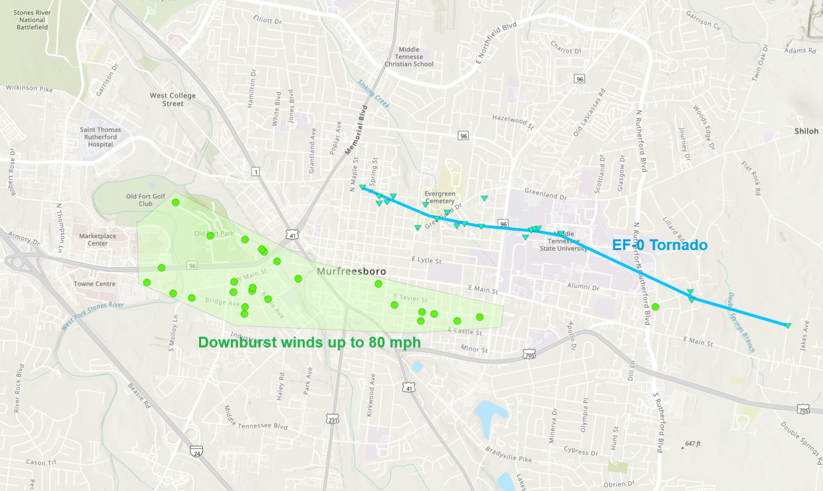
Tornado #1 - Murfreesboro, TN
Track Map
|
||||||||||||||||
The Enhanced Fujita (EF) Scale classifies tornadoes into the following categories:
| EF0 Weak 65-85 mph |
EF1 Moderate 86-110 mph |
EF2 Significant 111-135 mph |
EF3 Severe 136-165 mph |
EF4 Extreme 166-200 mph |
EF5 Catastrophic 200+ mph |
 |
|||||
Downbursts (Straight Line Winds)
|
Damaging Winds - Murfreesboro, TN
Damage Photos 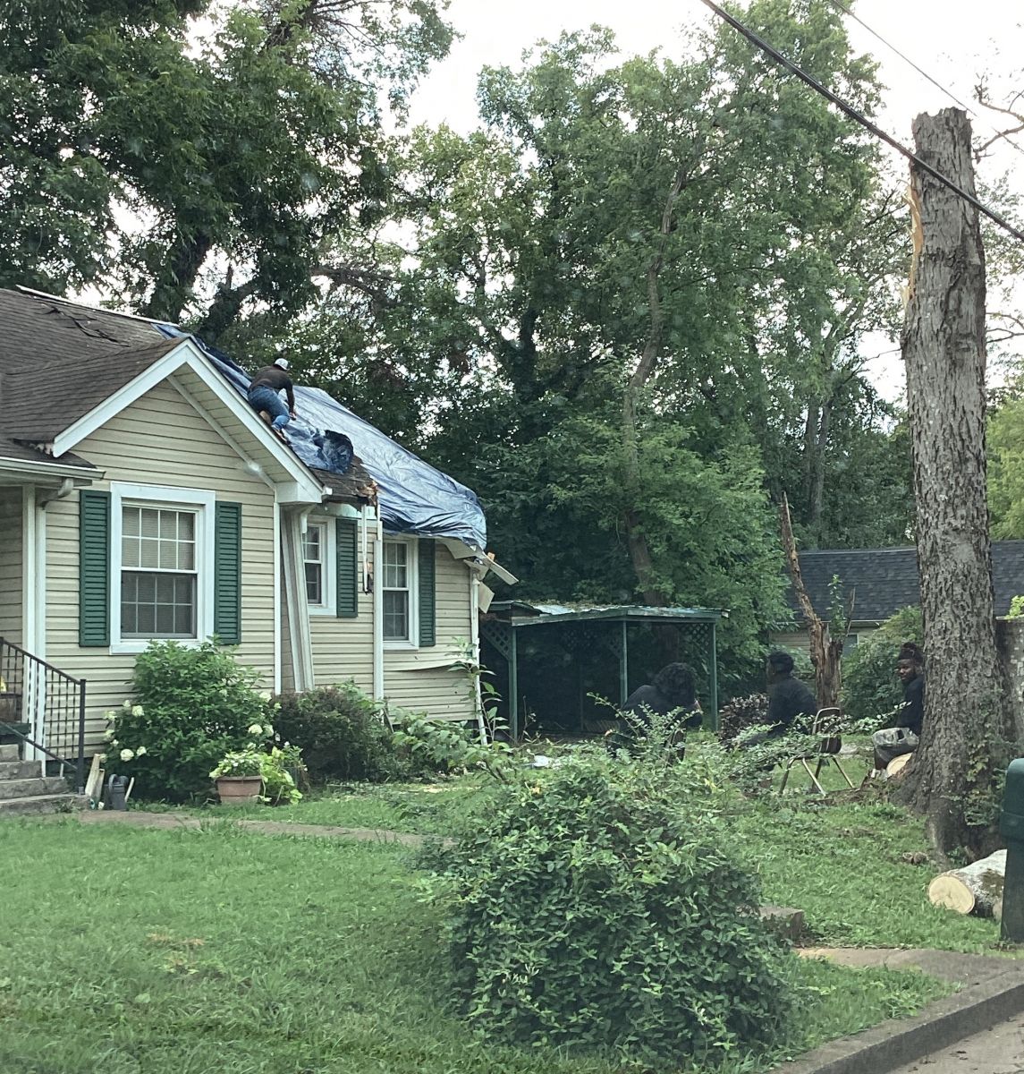
|
||||||||||
Damage Surveys
Public Information Statement
National Weather Service Nashville TN
508 PM CDT Tue Jul 30 2024

...NWS Damage Survey for 07/29/24 Tornado and Wind Event...

.Overview...A severe thunderstorm produced both a significant
downburst as well as a weak tornado in Murfreesboro, Tennessee.
Here are the findings from today`s survey.

..Tornado #1...

Rating:                 EF0
Estimated Peak Wind:    75 mph
Path Length /statute/:  3.38 miles
Path Width /maximum/:   100 yards
Fatalities:             0
Injuries:               0

Start Date:             07/29/2024
Start Time:             02:24 PM CDT
Start Location:         Murfreesboro / Rutherford County / TN
Start Lat/Lon:          35.855 / -86.3899

End Date:               07/29/2024
End Time:               02:29 PM CDT
End Location:           3 E Murfreesboro / Rutherford County / TN
End Lat/Lon:            35.8401 / -86.3331

Survey Summary:
A small, weak tornado moved through Murfreesboro, TN, also
impacting the Middle Tennessee State University campus. The main
damage was large tree branches down, with some trees uprooted.
Minor structural damage was noted at the stadium, including some
siding material off of one of the nearby buildings and some gate
and fencing damage. This is also where the viral video of the
trailer being blown around in the tornado was taken. The tornado
began just east of Memorial Boulevard, continued east-southeast
towards the MTSU campus, and ended east-southeast of campus on
Copper Hollow Drive.


..Murfreesboro Damaging Winds...

Estimated Peak Wind:    80 mph
Path Length /statute/:  2.55 miles
Path Width /maximum/:   1200 yards
Fatalities:             0
Injuries:               0

Start Date:             07/29/2024
Start Time:             02:25 PM CDT

End Date:               07/29/2024
End Time:               02:31 PM CDT

Survey Summary:
A swath of damaging winds occurred across parts of Murfreesboro.
Damage consisted of many trees down or uprooted, many branches
snapped off, and some structural damage, primarily due to trees or
branches falling. There was some minor roof damage to a few
buildings, including metal peeled up at a business and some
shingles lost on a few houses.


&&

EF Scale: The Enhanced Fujita Scale classifies tornadoes into the
following categories:

EF0.....65 to 85 mph
EF1.....86 to 110 mph
EF2.....111 to 135 mph
EF3.....136 to 165 mph
EF4.....166 to 200 mph
EF5.....>200 mph

NOTE:
The information in this statement is preliminary and subject to
change pending final review of the events and publication in
NWS Storm Data.


$$
Local Storm Reports
Preliminary Local Storm Report...Summary
National Weather Service Nashville TN
724 PM CDT Wed Jul 31 2024

..TIME...   ...EVENT...      ...CITY LOCATION...     ...LAT.LON...
..DATE...   ....MAG....      ..COUNTY LOCATION..ST.. ...SOURCE....
            ..REMARKS..

0215 PM     Tstm Wnd Dmg     4 SSW Smyrna            35.93N 86.54W
07/29/2024                   Rutherford         TN   Public

            Trees reported down near I-24 in Smyrna.

0217 PM     Tstm Wnd Dmg     5 W Murfreesboro        35.87N 86.48W
07/29/2024                   Rutherford         TN   Public

            Tspotter photo of part of siding blown off
            house near I-24 and I-840 in Blackman area.

0224 PM     Tornado          Murfreesboro            35.85N 86.39W
07/29/2024                   Rutherford         TN   NWS Storm Survey

            A small, weak EF-0 tornado moved through
            Murfreesboro, also impacting Middle
            Tennessee State University. Main damage was
            large tree branches down, with some trees
            uprooted. Minor structural damage was noted
            at the stadium, including some siding
            material off of one of the buildings and
            some gate/fencing damage. This is also where
            the viral video of the trailer being blown
            around with the tornado was seen. The
            tornado began just east of Memorial
            Boulevard, continued east-southeast towards
            MTSU, and ended southeast of campus on
            Copper Hollow Drive. Path length 3.38 miles,
            path width 100 yards. Max winds 75 mph.

0225 PM     Tstm Wnd Dmg     1 WSW Murfreesboro      35.85N 86.42W
07/29/2024                   Rutherford         TN   NWS Storm Survey

            A swath of intense damaging winds up to 80
            mph occurred across central Murfreesboro
            from around the Stones River to downtown.
            Damage consisted of many trees down or
            uprooted, many branches snapped off, and
            some structural damage, primarily due to
            trees or branches falling. There was some
            minor roof damage to a few buildings,
            including metal peeled up at a business and
            some shingles lost on a few houses.

0225 PM     Tstm Wnd Dmg     1 ENE Murfreesboro      35.86N 86.38W
07/29/2024                   Rutherford         TN   Public

            Tspotter report of trees down around the
            Oaklands Mansion.

0227 PM     Tstm Wnd Dmg     2 E Murfreesboro        35.85N 86.37W
07/29/2024                   Rutherford         TN   Public

            Social media reports of numerous trees down
            across the MTSU campus.

0227 PM     Tstm Wnd Dmg     2 E Murfreesboro        35.85N 86.37W
07/29/2024                   Rutherford         TN   Public

            Tspotter photo showed truck overturned and
            trees down at MTSU stadium.

0228 PM     Tstm Wnd Dmg     1 WSW Murfreesboro      35.85N 86.42W
07/29/2024                   Rutherford         TN   Public

            Tspotter report of several trees and traffic
            lights blown down on Old Fort Parkway.

0228 PM     Tstm Wnd Dmg     1 SE Murfreesboro       35.85N 86.39W
07/29/2024                   Rutherford         TN   Public

            Tree down on Maney St at Burton St.

0229 PM     Tstm Wnd Dmg     1 SSW Murfreesboro      35.83N 86.40W
07/29/2024                   Rutherford         TN   Broadcast Media

            Trees down on Haley Road.

0230 PM     Tstm Wnd Dmg     Murfreesboro            35.85N 86.39W
07/29/2024                   Rutherford         TN   Public

            Trees snapped on Academy St.

0315 PM     Tstm Wnd Dmg     3 NNW Tullahoma         35.41N 86.24W
07/29/2024                   Coffee             TN   Public

            Tspotter report of tree down across Hwy 269
            just north of Ralph Broadrick Rd.


&&

$$
 |
Media use of NWS Web News Stories is encouraged! Please acknowledge the NWS as the source of any news information accessed from this site. |
|