May 8-9, 2024 Tornadoes, Severe Storms, and Flooding
|
One of the most widespread severe thunderstorm events to impact Middle Tennessee in several years occurred from the early morning hours on Wednesday, May 8, 2024 into the early morning of Thursday, May 9, 2024. Several waves of severe thunderstorms, including many supercells, impacted the midstate during this period, first on Wednesday morning, then from Wednesday afternoon into Wednesday evening, and finally overnight Wednesday night. All together this event resulted in widespread wind damage across nearly every county of Middle Tennessee, large hail up to apple size, and at least 4 tornadoes. A Tornado Emergency was issued for a large EF-3 tornado that moved across Maury County during the afternoon of May 8th - the second one issued by NWS Nashville in 5 months. In addition, heavy rainfall as high as 9 inches fell during this 24 hour period, causing major flash flooding and river rises. Some of the worst flooding affected Robertson and Sumner Counties in northern Middle Tennessee, where Flash Flood Emergencies were issued and numerous water rescues were conducted. This is the first time NWS Nashville had issued both a Tornado Emergency and Flash Flood Emergency during the same weather event. All information is PRELIMINARY and subject to change! For more information on tornadoes across Middle Tennessee, visit our online tornado database at https://www.
|
|
Tornadoes
|
National Weather Service Storm Survey information regarding tornadoes and straight line wind damage that occurred on May 8-9, 2024. ALL DATA SHOULD BE CONSIDERED PRELIMINARY. |
|
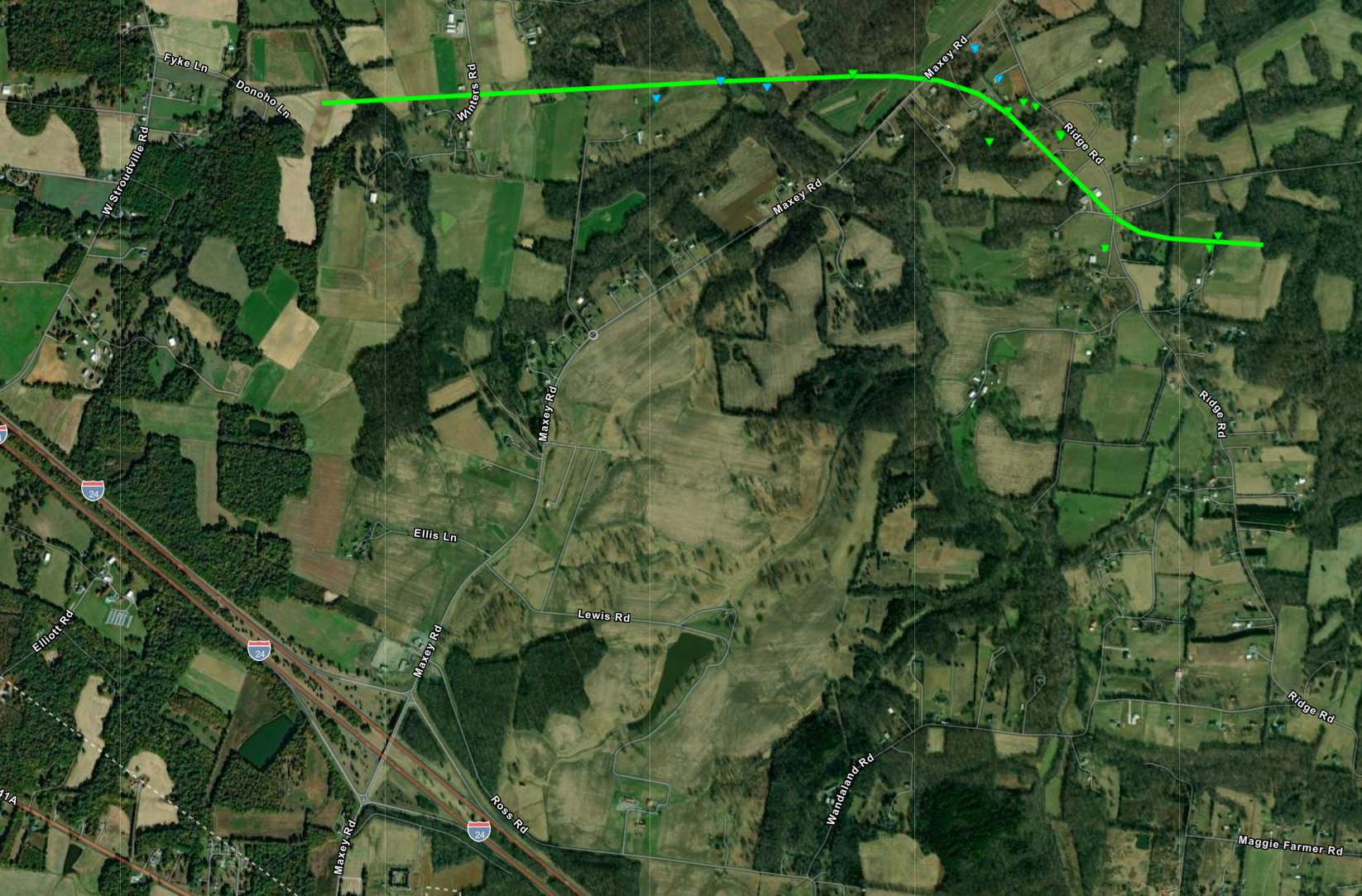
Tornado #1 - Cedar Hill, TN
Track Map
|
||||||||||||||||
|
Tornado #2 - Columbia/Spring Hill, TN
Track Map 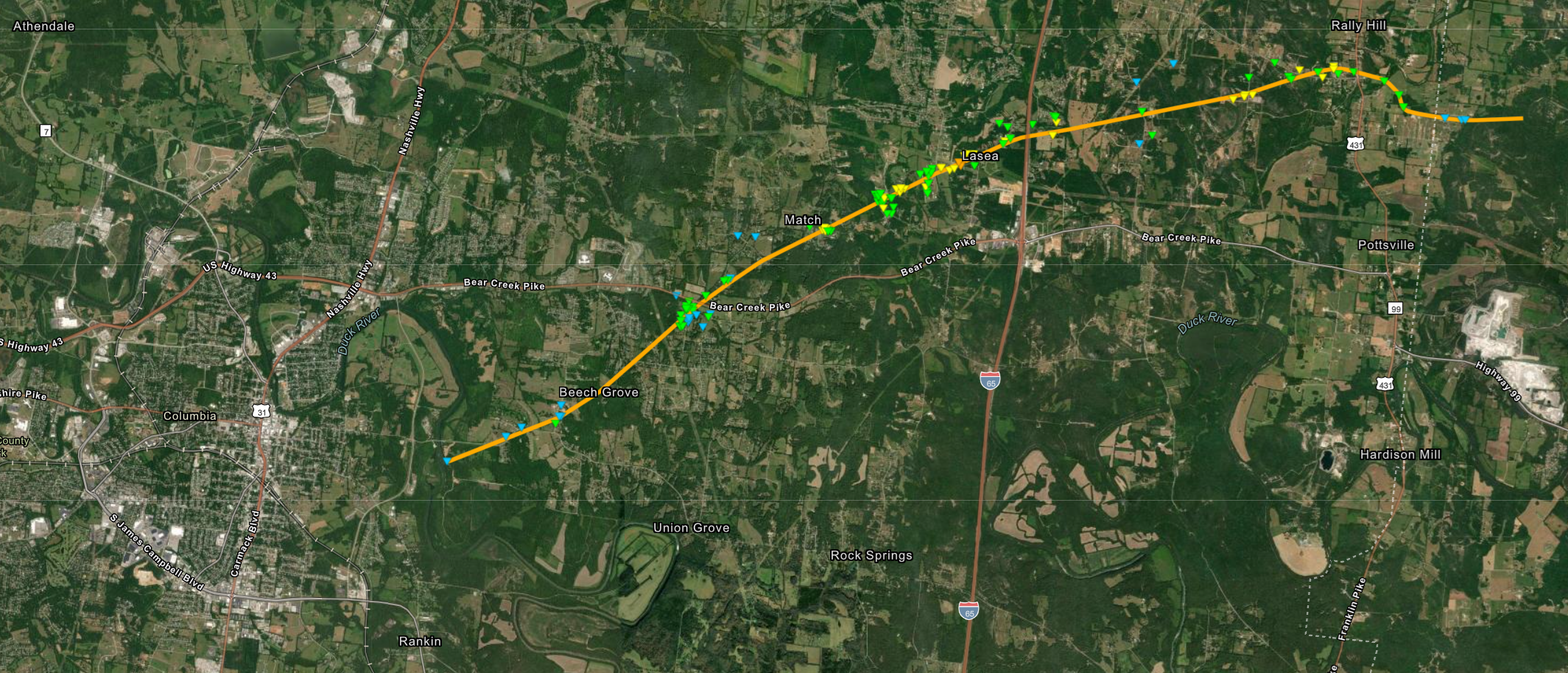 
|
||||||||||||||||
|
Tornado #3 - Christiana, TN
Track Map 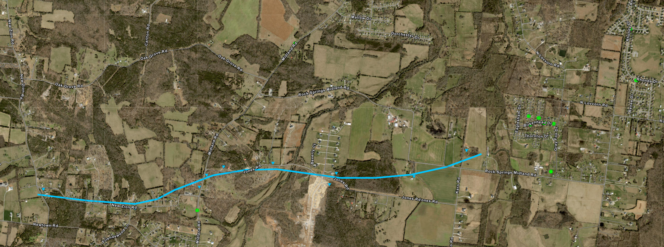
|
||||||||||||||||
|
Tornado #4 - Prospect, TN
Track Map 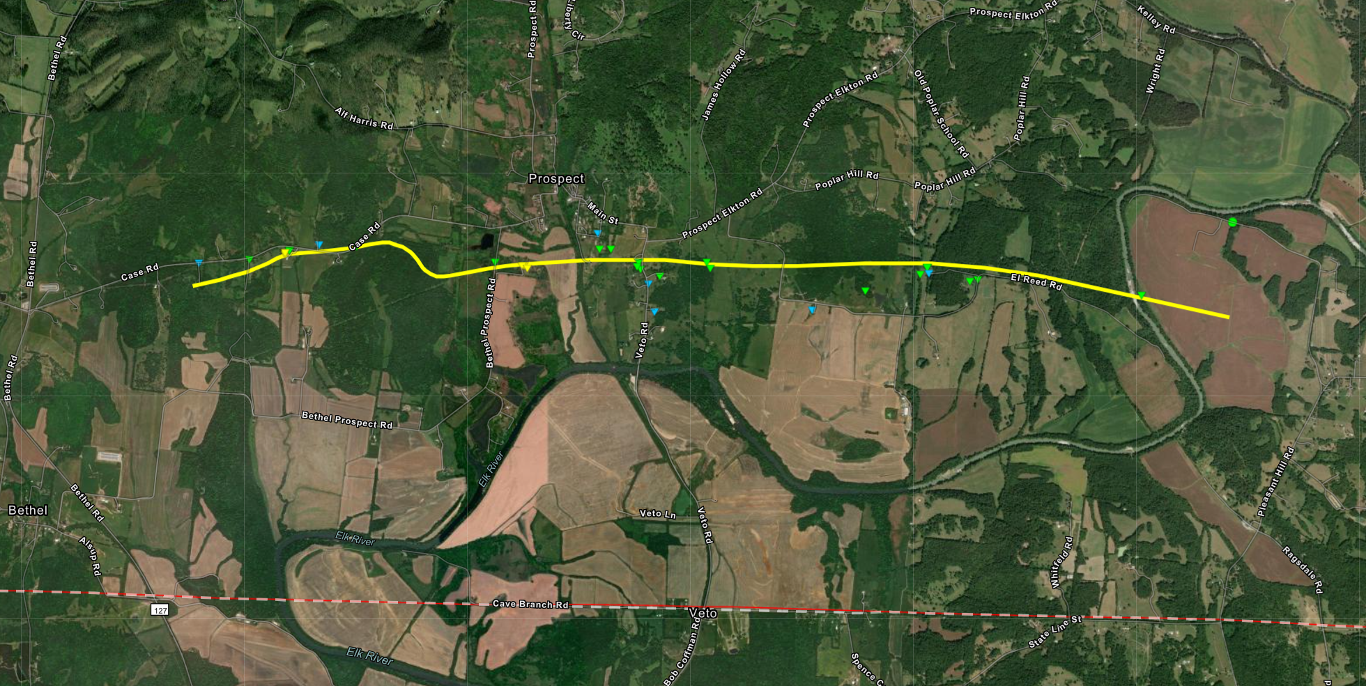
|
||||||||||||||||
The Enhanced Fujita (EF) Scale classifies tornadoes into the following categories:
| EF0 Weak 65-85 mph |
EF1 Moderate 86-110 mph |
EF2 Significant 111-135 mph |
EF3 Severe 136-165 mph |
EF4 Extreme 166-200 mph |
EF5 Catastrophic 200+ mph |
 |
|||||
Straight Line Winds
|
Straight Line Winds - Perry County, TN
|
||||||||||
|
Straight Line Winds - White House, TN
Damage Map 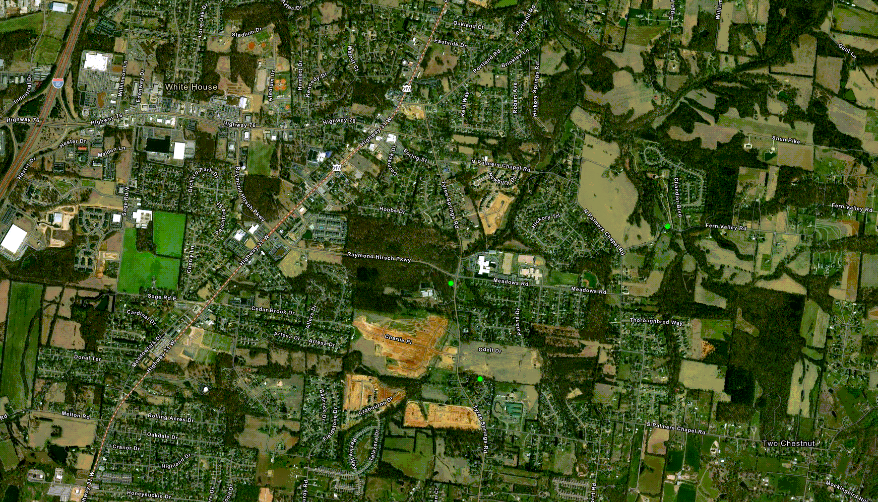
|
||||||||||
|
Straight Line Winds - Taylorsville, TN
Damage Map 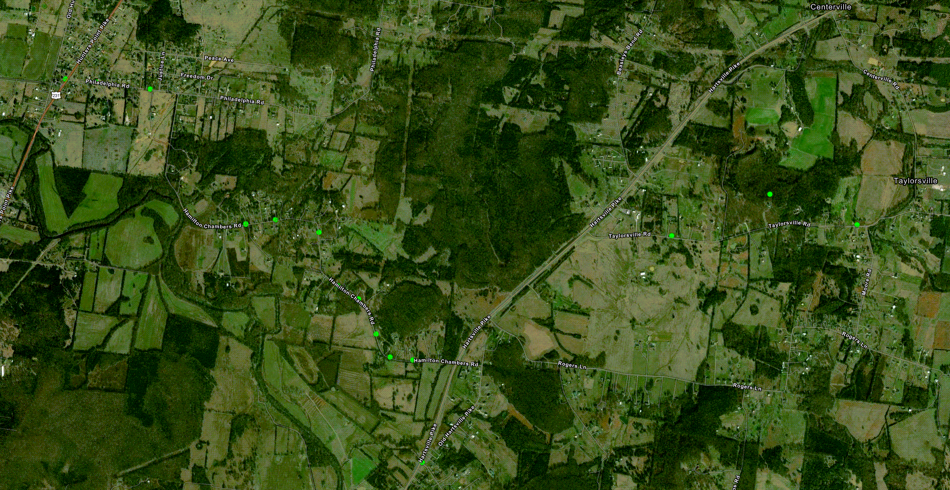
|
||||||||||
|
Straight Line Winds - Eagleville, TN
Damage Map 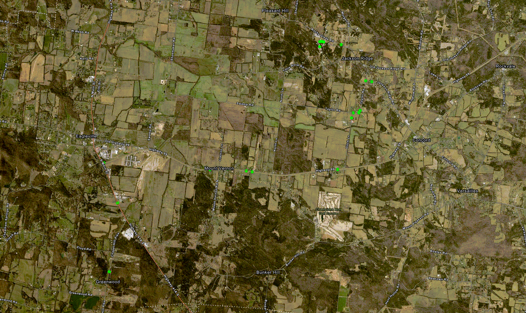
|
||||||||||
|
Straight Line Winds - Carthage, TN
Damage Map 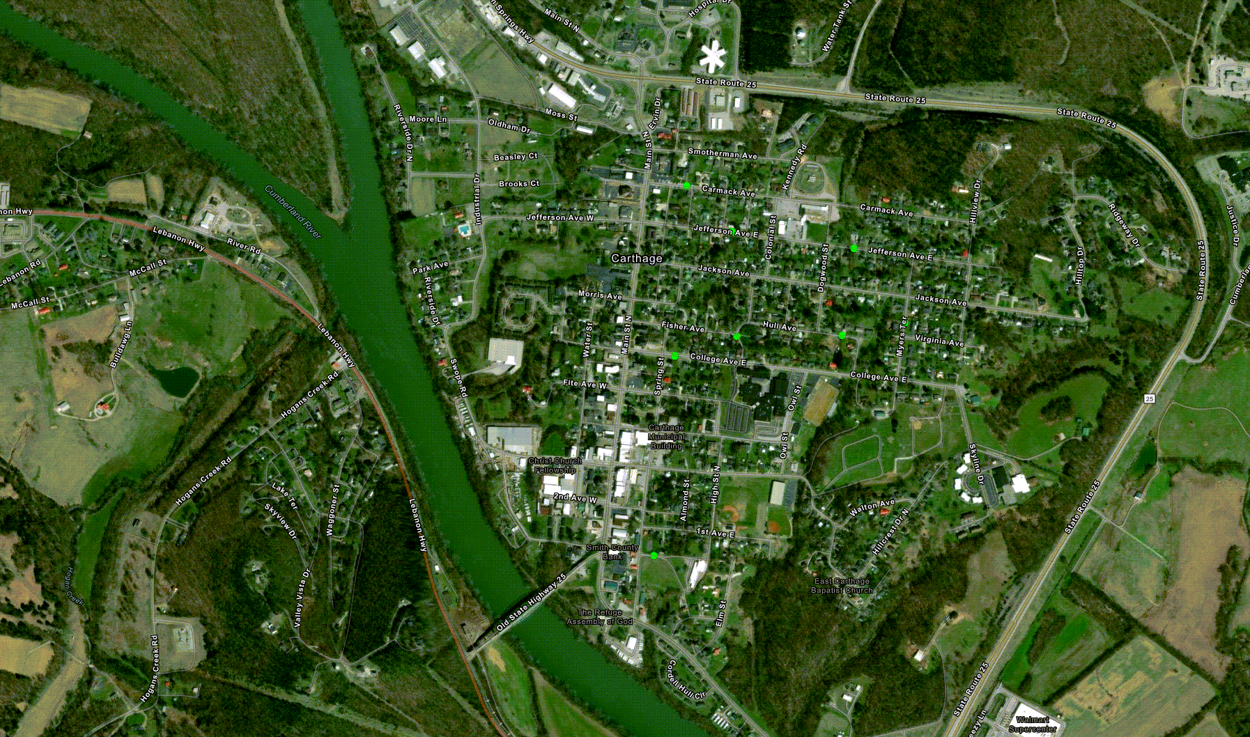
|
||||||||||
|
Straight Line Winds - Christiana, TN
Damage Map 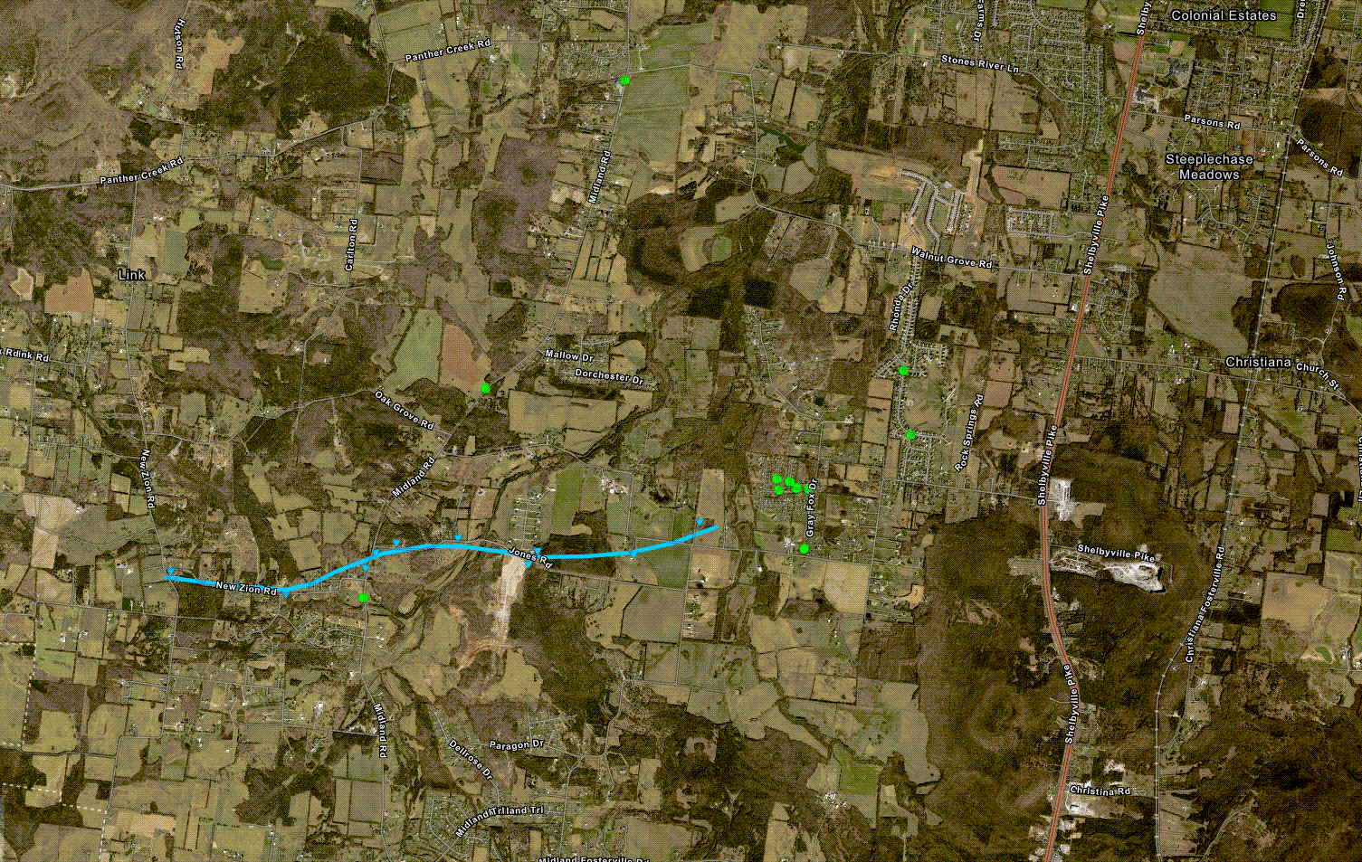
|
||||||||||
|
Straight Line Winds - Ivy Bluff, TN
Damage Map 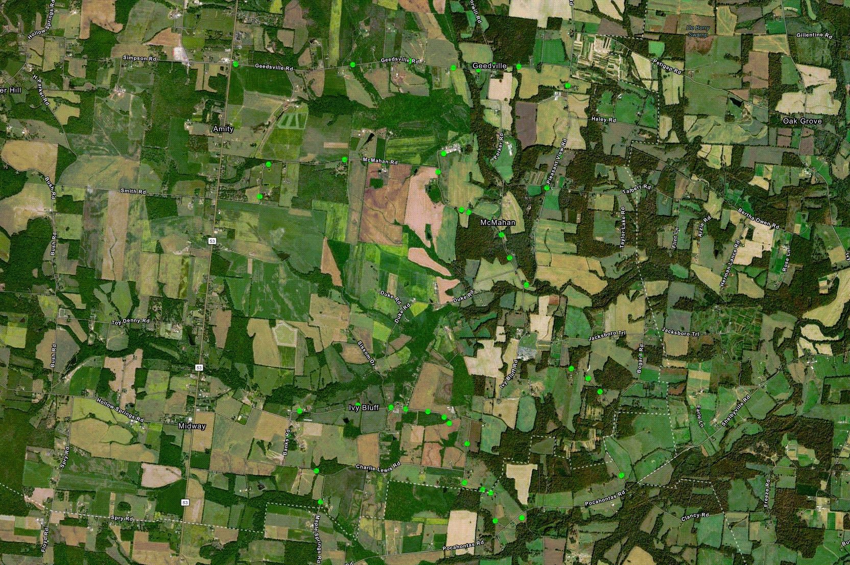
|
||||||||||
|
Straight Line Winds - Morrison, TN
Damage Map 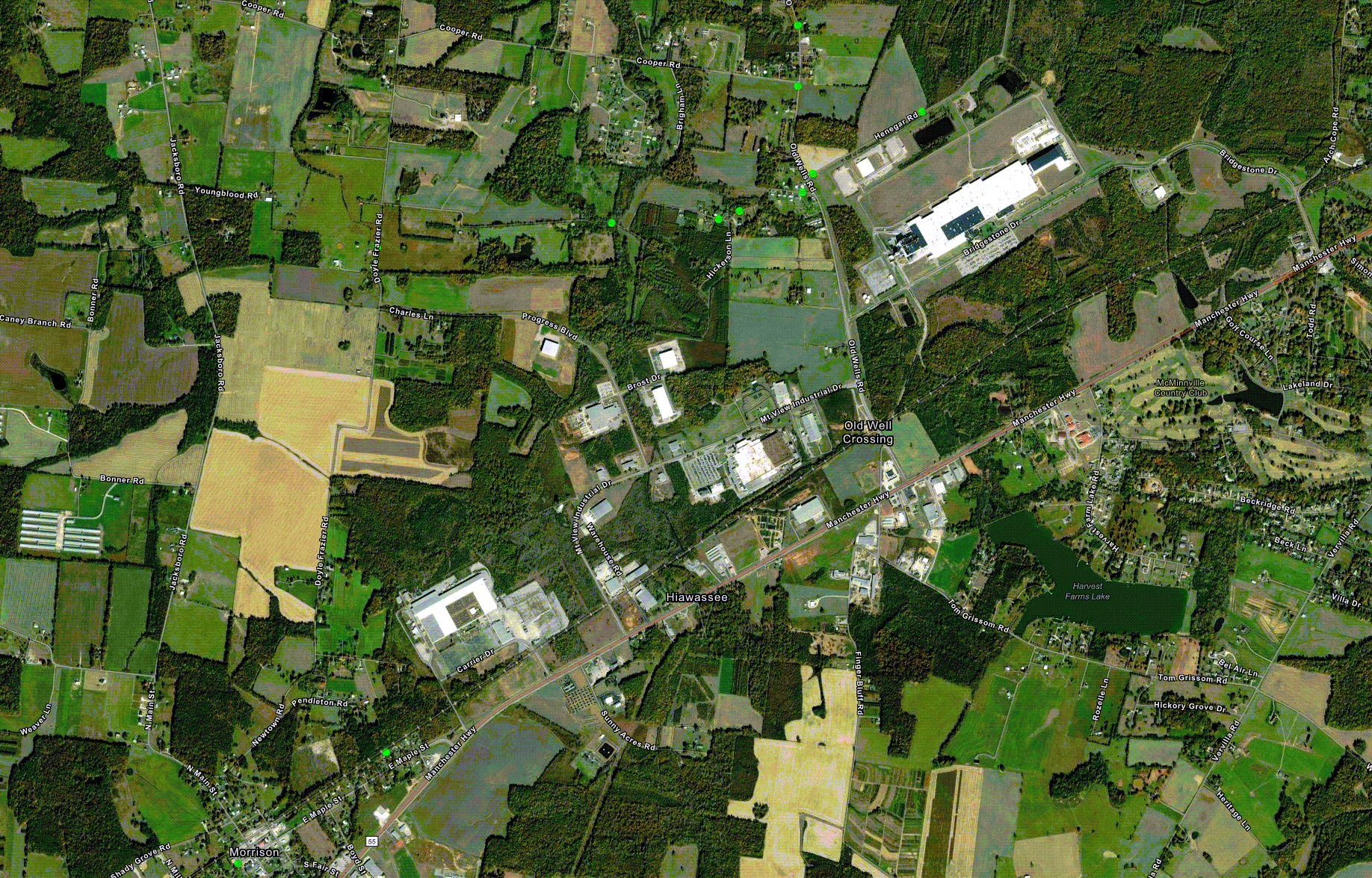
|
||||||||||
|
Straight Line Winds - Lawrence County, TN
|
||||||||||
|
Straight Line Winds - Culleoka, TN
Damage Map 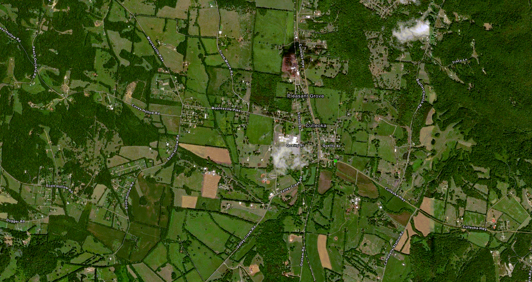
|
||||||||||
|
Straight Line Winds - Giles County, TN
Damage Map 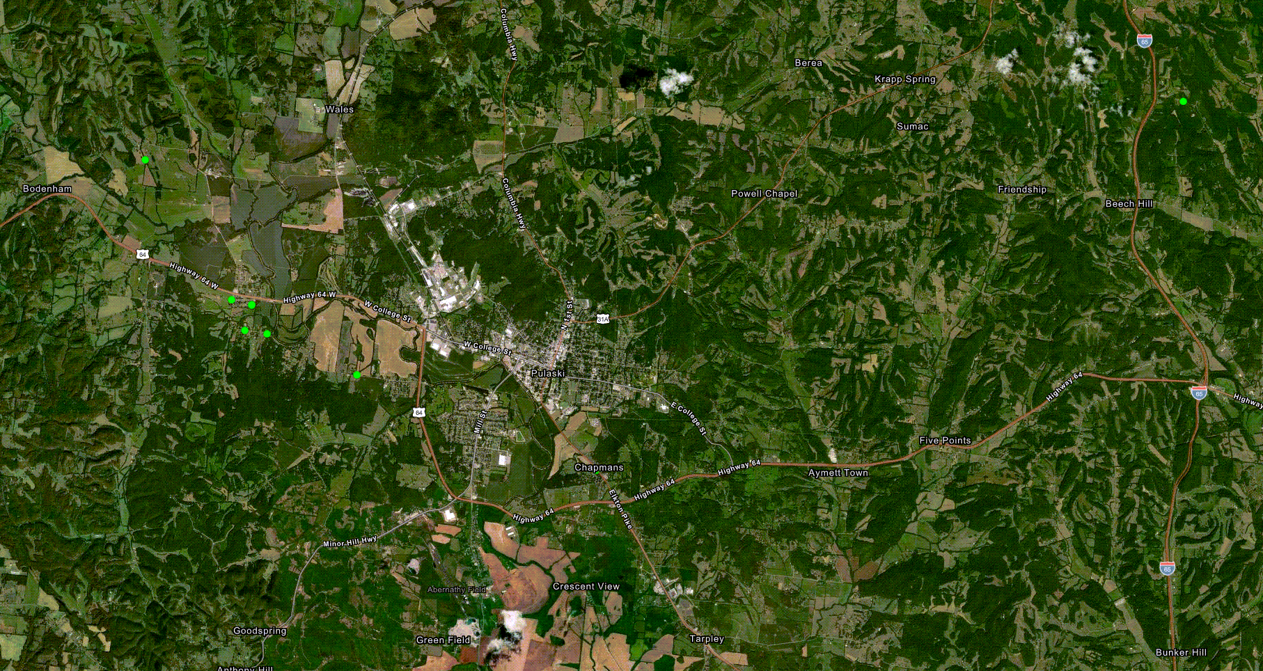
|
||||||||||
Damage Surveys
Public Information Statement
National Weather Service Nashville TN
205 AM CDT Tue May 14 2024

...NWS Damage Survey for 05/08/24 Tornado Event - Update #3...

.Update...Updated all info for the Cedar Hill tornado.

.Cedar Hill EF-1 Tornado...

Rating:                 EF1
Estimated Peak Wind:    90 mph
Path Length /statute/:  2.31 miles
Path Width /maximum/:   200 yards
Fatalities:             0
Injuries:               0

Start Date:             05/08/2024
Start Time:             02:43 PM CDT
Start Location:         7 S Adams / Robertson County / TN
Start Lat/Lon:          36.4717 / -87.1022

End Date:               05/08/2024
End Time:               02:49 PM CDT
End Location:           6 SSW Cedar Hill / Robertson County / TN
End Lat/Lon:            36.467 / -87.0631

Survey Summary:
An EF1 tornado touched down about 1 mile northeast of the I-24
and Stroudville Road intersection in far southwest Robertson
County and moved eastward. Several videos of the tornado were
taken by residents and stormchasers as the tornado crossed Winters
Road and Maxey Road, although the only damage was scattered blown
down trees. The tornado strengthened as it turned southeast and
followed Ridge Road, blowing down dozens of trees and damaging
several homes and barns. Three homes had shingle and roofing
material loss, along with gutter and soffit damage. One home had
14 trees snapped or uprooted, with one falling onto their home. An
older 20 by 40 barn on Ridge Rd south of Center Dr was picked up
and thrown in a northeasterly direction, with metal sheeting blown
into and wrapped around trees. The tornado took a sharp turn back
to the east and continued blowing down trees before it lifted
northeast of the Ridge Rd and Corlew Rd intersection.


.Columbia EF-3 Tornado...

Rating:                 EF3
Estimated Peak Wind:    140 mph
Path Length /statute/:  12.51 miles
Path Width /maximum/:   900 yards
Fatalities:             1
Injuries:               12

Start Date:             05/08/2024
Start Time:             05:37 PM CDT
Start Location:         3 ESE Columbia / Maury County / TN
Start Lat/Lon:          35.6095 / -87.0007

End Date:               05/08/2024
End Time:               06:07 PM CDT
End Location:           6 WNW Chapel Hill / Marshall County / TN
End Lat/Lon:            35.6622 / -86.8063

Survey Summary:
This EF-3 tornado touched down along the Duck River east of
Columbia and moved northeast causing tree damage and minor
structure damage on Iron Bridge Rd and Mount Olivet Rd. Multiple
homes received substantial damage along Cothran Rd and Cranford
Hollow Rd before the tornado crossed Highway 412. More intense
damage began to occur on Old Highway 99 and Blackburn Lane where
large sections of roofs were removed from houses and hundreds of
trees were snapped or uprooted. The tornado reached its maximum
strength along Blackburn Rd and Lasea Rd where a large transmission
power truss collapsed, a house was destroyed with only a small
interior room left standing, and a doublewide mobile home was swept
away. The tornado continued northeast damaging additional homes and
blowing down trees before crossing I-65 near mile marker 47. More
homes were heavily damaged and a wide swath of trees was blown
down along Rally Hill Cutoff Rd and Kedron Rd. The tornado crossed
Highway 431 near Kedron Rd and continued to blown down trees as it
took a sharp southeastward jog before lifting in a forest east of
Moses Road in far western Marshall County.


.Christiana EF-0 Tornado...

Rating:                 EF0
Estimated Peak Wind:    80 mph
Path Length /statute/:  3.02 miles
Path Width /maximum/:   100 yards
Fatalities:             0
Injuries:               0

Start Date:             05/08/2024
Start Time:             06:32 PM CDT
Start Location:         9 ESE Eagleville / Rutherford County / TN
Start Lat/Lon:          35.6936 / -86.5033

End Date:               05/08/2024
End Time:               06:36 PM CDT
End Location:           9 NW Bell Buckle / Rutherford County / TN
End Lat/Lon:            35.6975 / -86.4508

Survey Summary:
An EF-0 tornado touched down near the intersection of Threet Rd
and New Zion Rd. The tornado moved east along New Zion Rd snapping
large branches off from hardwood trees. Trees were uprooted in all
directions near the intersection of Midland Rd and Jones Rd. The
tornado continued east along Jones Rd snapping large limbs and
uprooting a few trees before the tornado transitioned to straight
line winds near the Gray Fox neighborhood.


.Prospect EF-2 Tornado...

Rating:                 EF2
Estimated Peak Wind:    115 mph
Path Length /statute/:  5.91 miles
Path Width /maximum/:   600 yards
Fatalities:             0
Injuries:               1

Start Date:             05/08/2024
Start Time:             07:50 PM CDT
Start Location:         6 ENE Lester / Giles County / AL
Start Lat/Lon:          35.0232 / -87.0405

End Date:               05/08/2024
End Time:               08:00 PM CDT
End Location:           3 SSW Elkton / Giles County / TN
End Lat/Lon:            35.0183 / -86.9367

Survey Summary:
This EF-2 tornado touched down along Case Road southwest of
Prospect where some trees were damaged. As the tornado continued
east, a home sustained roof damage, and a tied-down manufactured
home was completely removed from its base and destroyed. One
person was critically injured in the manufactured home. As the
tornado continued east, major tree damage occurred along Bethel
Prospect Road, a metal shop building was destroyed, and another
tied-down mobile was completely lifted off its base and wrapped
around a tree, with the remaining debris blown down a hillside.
More trees continued to be blown down with roof damage to some
homes and outbuildings as the tornado passed across the south
edge of the town of Prospect and crossed Veto Road. The tornado
continued to snap and uproot hundreds of trees as it moved up and
down hills along El Reed Road before crossing the Elk River and
dissipating.

&&

EF Scale: The Enhanced Fujita Scale classifies tornadoes into the
following categories:

EF0.....65 to 85 mph
EF1.....86 to 110 mph
EF2.....111 to 135 mph
EF3.....136 to 165 mph
EF4.....166 to 200 mph
EF5.....>200 mph

NOTE:
The information in this statement is preliminary and subject to
change pending final review of the events and publication in
NWS Storm Data.


$$

Barnwell/Hurley/Mueller/Shamburger
Local Storm Reports
Preliminary Local Storm Report...Summary
National Weather Service Nashville TN
217 AM CDT Fri May 17 2024
..TIME... ...EVENT... ...CITY LOCATION... ...LAT.LON...
..DATE... ....MAG.... ..COUNTY LOCATION..ST.. ...SOURCE....
..REMARKS..
0425 AM Tstm Wnd Dmg 5 ESE Bumpus Mills 36.59N 87.76W
05/08/2024 Stewart TN Broadcast Media
Report of trees down in the Big Rock area.
0425 AM Tstm Wnd Dmg 5 ESE Bumpus Mills 36.59N 87.76W
05/08/2024 Stewart TN Broadcast Media
Report of trees down in the Big Rock area.
0425 AM Tstm Wnd Dmg 5 ESE Bumpus Mills 36.59N 87.76W
05/08/2024 Stewart TN Broadcast Media
Report of trees down in the Big Rock area.
0625 AM Tstm Wnd Dmg 7 NW Gallatin 36.45N 86.54W
05/08/2024 Sumner TN Public
Facebook report of a tree down in
Cottontown.
0647 AM Tstm Wnd Dmg Lafayette 36.53N 86.04W
05/08/2024 Macon TN Public
Facebook report of several trees blown down
in Lafayette around Ellington Dr at Meador
Dr.
0705 AM Hail 1 SSE Red Boiling Sprin 36.52N 85.85W
05/08/2024 E1.00 Inch Macon TN Public
0705 AM Hail 1 SSE Red Boiling Sprin 36.52N 85.85W
05/08/2024 E1.00 Inch Macon TN Public
.
0705 AM Hail 1 SSE Red Boiling Sprin 36.52N 85.85W
05/08/2024 E1.00 Inch Macon TN Public
.
0706 AM Tstm Wnd Dmg 3 SSE Red Boiling Sprin 36.50N 85.83W
05/08/2024 Macon TN Public
Downed trees. Delayed report.
0706 AM Tstm Wnd Dmg 3 SSE Red Boiling Sprin 36.50N 85.83W
05/08/2024 Macon TN Public
Downed trees. Delayed report.
0739 AM Hail 7 WNW Livingston 36.41N 85.44W
05/08/2024 E1.75 Inch Overton TN Public
.
0739 AM Hail 7 WNW Livingston 36.41N 85.44W
05/08/2024 E1.75 Inch Overton TN Public
0739 AM Hail 7 WNW Livingston 36.41N 85.44W
05/08/2024 E1.75 Inch Overton TN Public
.
0740 AM Tstm Wnd Dmg 2 W Livingston 36.39N 85.35W
05/08/2024 Overton TN Emergency Mngr
Trees down on Walnut Grove Road.
0740 AM Tstm Wnd Dmg 2 W Livingston 36.39N 85.35W
05/08/2024 Overton TN Emergency Mngr
Trees down on Walnut Grove Road.
0740 AM Tstm Wnd Dmg 2 W Livingston 36.39N 85.35W
05/08/2024 Overton TN Emergency Mngr
Trees down on Walnut Grove Road.
0743 AM Tstm Wnd Dmg 1 S Livingston 36.38N 85.33W
05/08/2024 Overton TN Emergency Mngr
Trees down on west Main Street in
Livingston.
0743 AM Tstm Wnd Dmg 1 S Livingston 36.38N 85.33W
05/08/2024 Overton TN Emergency Mngr
Trees down on west Main Street in
Livingston.
0743 AM Tstm Wnd Dmg 1 S Livingston 36.38N 85.33W
05/08/2024 Overton TN Emergency Mngr
Trees down on west Main Street in
Livingston.
0839 AM Flash Flood Springfield 36.50N 86.88W
05/08/2024 Robertson TN Emergency Mngr
Multiple reports of flooded roads across
Robertson County.
0839 AM Flash Flood Springfield 36.50N 86.88W
05/08/2024 Robertson TN Emergency Mngr
Multiple reports of flooded roads across
Robertson County.
0839 AM Flash Flood Springfield 36.50N 86.88W
05/08/2024 Robertson TN Emergency Mngr
Multiple reports of flooded roads across
Robertson County.
0842 AM Flash Flood Hendersonville 36.29N 86.60W
05/08/2024 Sumner TN 911 Call Center
Reports of roads flooded in Hendersonville
including Stop Thirty Rd at Drakes Creek Rd
and Indian Lake Blvd at Old Shackle Island
Rd.
0842 AM Flash Flood Clarksville 36.56N 87.35W
05/08/2024 Montgomery TN Public
Facebook reports of several roads flooded
across Clarksville including Trenton Road.
0842 AM Flash Flood Clarksville 36.56N 87.35W
05/08/2024 Montgomery TN Public
Facebook reports of several roads flooded
across Clarksville including Trenton Road.
0842 AM Flash Flood Hendersonville 36.29N 86.60W
05/08/2024 Sumner TN 911 Call Center
Reports of roads flooded in Hendersonville
including Stop Thirty Rd at Drakes Creek Rd
and Indian Lake Blvd at Old Shackle Island
Rd.
0842 AM Flash Flood Hendersonville 36.29N 86.60W
05/08/2024 Sumner TN 911 Call Center
Reports of roads flooded in Hendersonville
including Stop Thirty Rd at Drakes Creek Rd
and Indian Lake Blvd at Old Shackle Island
Rd.
0842 AM Flash Flood Clarksville 36.56N 87.35W
05/08/2024 Montgomery TN Public
Facebook reports of several roads flooded
across Clarksville including Trenton Road.
0845 AM Flash Flood White House 36.46N 86.67W
05/08/2024 Robertson TN Public
Tspotter report of Sage Road at Hwy 76 in
White House flooded and closed.
0845 AM Flash Flood White House 36.46N 86.67W
05/08/2024 Robertson TN Public
Tspotter report of Sage Road at Hwy 76 in
White House flooded and closed.
0845 AM Flash Flood White House 36.46N 86.67W
05/08/2024 Robertson TN Public
Tspotter report of Sage Road at Hwy 76 in
White House flooded and closed.
0850 AM Flash Flood Greenbrier 36.42N 86.80W
05/08/2024 Robertson TN Emergency Mngr
Multiple reports of flooded roads in the
Greenbrier and White House areas.
0850 AM Flash Flood Greenbrier 36.42N 86.80W
05/08/2024 Robertson TN Emergency Mngr
Multiple reports of flooded roads in the
Greenbrier and White House areas.
0850 AM Flash Flood Greenbrier 36.42N 86.80W
05/08/2024 Robertson TN Emergency Mngr
Multiple reports of flooded roads in the
Greenbrier and White House areas.
0853 AM Flash Flood 1 S Goodlettsville 36.32N 86.71W
05/08/2024 Davidson TN Public
Tspotter reports of I-65 onramp at Long
Hollow Pike and Caldwell Drive flooded.
0853 AM Flash Flood 1 S Goodlettsville 36.32N 86.71W
05/08/2024 Davidson TN Public
Tspotter reports of I-65 onramp at Long
Hollow Pike and Caldwell Drive flooded.
0853 AM Flash Flood 1 S Goodlettsville 36.32N 86.71W
05/08/2024 Davidson TN Public
Tspotter reports of I-65 onramp at Long
Hollow Pike and Caldwell Drive flooded.
0950 AM Flood 3 ENE Monterey 36.16N 85.20W
05/08/2024 Overton TN Emergency Mngr
Three reports of water over Highway 164
between Pilgrim Circle and Memory Ln.
0950 AM Flood 3 ENE Monterey 36.16N 85.20W
05/08/2024 Overton TN Emergency Mngr
Three reports of water over Highway 164
between Pilgrim Circle and Memory Ln.
0950 AM Flood 3 ENE Monterey 36.16N 85.20W
05/08/2024 Overton TN Emergency Mngr
Three reports of water over Highway 164
between Pilgrim Circle and Memory Ln.
0956 AM Flash Flood 2 SW White House 36.45N 86.69W
05/08/2024 Robertson TN Emergency Mngr
Photos show Melton Road at Union Road
flooded and impassable.
0956 AM Flash Flood 2 SW White House 36.45N 86.69W
05/08/2024 Robertson TN Emergency Mngr
Photos show Melton Road at Union Road
flooded and impassable.
0956 AM Flash Flood 2 SW White House 36.45N 86.69W
05/08/2024 Robertson TN Emergency Mngr
Photos show Melton Road at Union Road
flooded and impassable.
1007 AM Flood 1 ESE Guthrie 36.64N 87.16W
05/08/2024 Montgomery TN Public
Water over the road reported.
1029 AM Flash Flood 3 NNW Greenbrier 36.46N 86.83W
05/08/2024 Robertson TN Emergency Mngr
Road flooded and house surrounded by water
on Old Greenbrier Pike at Worsham Springs
Rd.
1029 AM Flash Flood 3 NNW Greenbrier 36.46N 86.83W
05/08/2024 Robertson TN Emergency Mngr
Road flooded and house surrounded by water
on Old Greenbrier Pike at Worsham Springs
Rd.
1029 AM Flash Flood 3 NNW Greenbrier 36.46N 86.83W
05/08/2024 Robertson TN Emergency Mngr
Road flooded and house surrounded by water
on Old Greenbrier Pike at Worsham Springs
Rd.
1050 AM Flash Flood 2 SSW Cross Plains 36.51N 86.69W
05/08/2024 Robertson TN Emergency Mngr
Significant flash flooding ongoing with
Empson Rd flooded and impassable between
Covington Rd and Cross Plains Rd.
1050 AM Flash Flood 2 SSW Cross Plains 36.51N 86.69W
05/08/2024 Robertson TN Emergency Mngr
Significant flash flooding ongoing with
Empson Rd flooded and impassable between
Covington Rd and Cross Plains Rd.
1050 AM Flash Flood 2 SSW Cross Plains 36.51N 86.69W
05/08/2024 Robertson TN Emergency Mngr
Significant flash flooding ongoing with
Empson Rd flooded and impassable between
Covington Rd and Cross Plains Rd.
1114 AM Flash Flood 4 WNW Algood 36.21N 85.51W
05/08/2024 Putnam TN Emergency Mngr
North Allen Road at Dodson Branch Hwy
flooded and impassable.
1114 AM Flash Flood 4 WNW Algood 36.21N 85.51W
05/08/2024 Putnam TN Emergency Mngr
North Allen Road at Dodson Branch Hwy
flooded and impassable.
1114 AM Flash Flood 4 WNW Algood 36.21N 85.51W
05/08/2024 Putnam TN Emergency Mngr
North Allen Road at Dodson Branch Hwy
flooded and impassable.
1130 AM Flood 6 W Gallatin 36.39N 86.56W
05/08/2024 Sumner TN Emergency Mngr
Flooding in vicinity of upper station camp
creek road and liberty lane.
1130 AM Flood 6 W Gallatin 36.39N 86.56W
05/08/2024 Sumner TN Emergency Mngr
Flooding in vicinity of upper station camp
creek road and liberty lane.
1239 PM Flash Flood 3 W Springfield 36.50N 86.93W
05/08/2024 Robertson TN Emergency Mngr
New Chapel Road flooded and impassable.
0220 PM Tstm Wnd Dmg 3 NNW Fredonia 36.48N 87.25W
05/08/2024 Montgomery TN Public
Facebook report of a tree snapped near
McAdoo Creek Road and Highway 12 along with
damage to a barn roof.
0220 PM Hail 8 E Ashland City 36.26N 86.92W
05/08/2024 E1.00 Inch Davidson TN Public
Twitter photo showed hail up to quarter size
in the Beaman Park area.
0243 PM Tornado 7 ENE Fredonia 36.47N 87.10W
05/08/2024 Robertson TN NWS Storm Survey
An EF1 tornado touched down about 1 mile
northeast of the I-24 and Stroudville Road
intersection in far southwest Robertson
County and moved eastward. Several videos of
the tornado were taken by residents and
stormchasers as the tornado crossed Winters
Road and Maxey Road, although the only
damage was scattered blown down trees. The
tornado strengthened as it turned southeast
and followed Ridge Road, blowing down dozens
of trees and damaging several homes and
barns. Three homes had shingle and roofing
material loss, along with gutter and soffit
damage. One home had 14 trees snapped or
uprooted, with one falling onto their home.
An older 20 by 40 barn on Ridge Rd south of
Center Dr was picked up and thrown in a
northeasterly direction, with metal sheeting
blown into and wrapped around trees. The
tornado took a sharp turn back to the east
and continued blowing down trees before it
lifted northeast of the Ridge Rd and Corlew
Rd intersection.
0247 PM Tornado 7 E Fredonia 36.45N 87.10W
05/08/2024 Robertson TN Public
Reported by spotter on mile marker 19 on
I-24.
0254 PM Tornado 4 NW Coopertown 36.48N 87.03W
05/08/2024 Robertson TN Trained Spotter
Still ongoing northwest of Coopertown. Exact
location estimated by radar.
0257 PM Hail Cedar Hill 36.55N 87.00W
05/08/2024 E2.00 Inch Robertson TN Public
Facebook report of 2 inch diameter hail in
Cedar Hill.
0301 PM Flash Flood 1 ENE White House 36.47N 86.65W
05/08/2024 Sumner TN Public
Flooding reported in White House High
School.
0315 PM Hail 7 NNE Springfield 36.59N 86.83W
05/08/2024 E2.50 Inch Robertson TN Public
Facebook report of tennis ball size hail in
the Youngville area.
0322 PM Hail Bumpus Mills 36.61N 87.84W
05/08/2024 E1.00 Inch Stewart TN Emergency Mngr
0328 PM Hail 2 N Cross Plains 36.57N 86.67W
05/08/2024 E1.00 Inch Robertson TN Public
Report from mPING: Quarter (1.00 in.).
0330 PM Hail 1 E Bumpus Mills 36.61N 87.82W
05/08/2024 M3.00 Inch Stewart TN Public
0341 PM Funnel Cloud 10 W Woodlawn 36.55N 87.67W
05/08/2024 Stewart TN Public
0354 PM Hail 1 SSE Portland 36.58N 86.51W
05/08/2024 M1.25 Inch Sumner TN Public
0405 PM Tstm Wnd Dmg 8 W Lobelville 35.73N 87.93W
05/08/2024 Perry TN Emergency Mngr
Trees and powerlines down near Pine View.
Time is radar estimated.
0405 PM Hail Clarksville 36.56N 87.35W
05/08/2024 E3.00 Inch Montgomery TN Public
Tspotter photo of apple size hail in
Clarksville.
0406 PM Hail 2 SW Clarksville 36.53N 87.36W
05/08/2024 M1.75 Inch Montgomery TN Public
Report from mPING: Golf Ball (1.75 in.).
0408 PM Hail Clarksville 36.56N 87.35W
05/08/2024 E1.75 Inch Montgomery TN Public
0415 PM Hail 9 S Linden 35.48N 87.83W
05/08/2024 M2.75 Inch Perry TN Public
Reported in the Flat Woods area.
0417 PM Hail 5 SSW Clarksville 36.49N 87.37W
05/08/2024 E2.00 Inch Montgomery TN Public
0417 PM Funnel Cloud 7 W Tennessee Ridge 36.32N 87.90W
05/08/2024 Houston TN Public
0424 PM Tstm Wnd Dmg 9 S Linden 35.48N 87.83W
05/08/2024 Perry TN Emergency Mngr
Trees and powerlines down. Time is radar
estimated.
0436 PM Hail 2 SE Hohenwald 35.52N 87.53W
05/08/2024 E1.25 Inch Lewis TN Public
Report from mPING: Half Dollar (1.25 in.).
0443 PM Hail Hohenwald 35.55N 87.55W
05/08/2024 E1.75 Inch Lewis TN Emergency Mngr
0443 PM Hail 2 SE Hohenwald 35.52N 87.53W
05/08/2024 E1.75 Inch Lewis TN Public
Estimated golf ball size hail.
0444 PM Hail 2 SE Hohenwald 35.52N 87.53W
05/08/2024 E1.50 Inch Lewis TN Public
Estimated 1.5 inch hail.
0454 PM Hail 2 SE Hohenwald 35.52N 87.53W
05/08/2024 E1.75 Inch Lewis TN Public
Estimated golf ball size hail.
0500 PM Hail 5 WSW Cross Plains 36.50N 86.76W
05/08/2024 M1.75 Inch Robertson TN Public
Facebook report of estimated golf ball size
hail along Baggett Road east of Springfield.
0502 PM Funnel Cloud 8 WNW Summertown 35.47N 87.44W
05/08/2024 Lewis TN Emergency Mngr
0503 PM Funnel Cloud 2 SW Charlotte 36.17N 87.37W
05/08/2024 Dickson TN Storm Chaser
0509 PM Funnel Cloud 1 W Coopertown 36.44N 86.99W
05/08/2024 Robertson TN Public
0509 PM Hail 1 NE White House 36.48N 86.66W
05/08/2024 M1.00 Inch Robertson TN Public
Report from mPING: Quarter (1.00 in.).
0510 PM Hail Cumberland Furnace 36.27N 87.36W
05/08/2024 E1.00 Inch Dickson TN Public
Facebook photo showed quarter size hail in
Cumberland Furnace.
0515 PM Hail 2 N White House 36.50N 86.67W
05/08/2024 E2.00 Inch Robertson TN Emergency Mngr
0517 PM Hail 1 NE White House 36.48N 86.66W
05/08/2024 E1.00 Inch Robertson TN Public
Report from mPING: Quarter (1.00 in.).
0527 PM Tstm Wnd Dmg Ashland City 36.28N 87.06W
05/08/2024 Cheatham TN Public
Facebook photo showed tree down on home in
Ashland City off River Road.
0528 PM Tstm Wnd Dmg 4 S Ashland City 36.23N 87.05W
05/08/2024 Cheatham TN Emergency Mngr
Trees and powerlines down on Overlook Road.
Time is radar estimated.
0528 PM Tstm Wnd Dmg 6 SE Ashland City 36.20N 86.99W
05/08/2024 Cheatham TN Emergency Mngr
Trees and powerlines down. Time is radar
estimated.
0529 PM Tstm Wnd Dmg 7 NNE Lebanon 36.30N 86.27W
05/08/2024 Wilson TN Emergency Mngr
Trees and powerlines down on Thomas Road
near the county line of Trousdale/Wilson
Counties. Tornado damage possible.
0530 PM Tstm Wnd Dmg 2 ESE White House 36.46N 86.63W
05/08/2024 Sumner TN Public
Several trees were blown down near
intersection of Meadows and N Palmers Chapel
Rd.
0530 PM Tstm Wnd Dmg 3 E White House 36.46N 86.62W
05/08/2024 Sumner TN Public
Several trees were blown down along Fern
Valley Road.
0530 PM Hail 3 E Ashland City 36.26N 87.00W
05/08/2024 E2.00 Inch Cheatham TN Public
Estimated 2 inch hail.
0534 PM Hail 6 S Coopertown 36.35N 86.95W
05/08/2024 E1.25 Inch Cheatham TN Public
Report from mPING: Half Dollar (1.25 in.).
0537 PM Tornado 3 ESE Columbia 35.61N 87.00W
05/08/2024 Maury TN NWS Storm Survey
*** 1 FATAL, 12 INJ ***
Updated info. This EF-3 tornado touched down
along the Duck River east of Columbia and
moved northeast causing tree damage and
minor structure damage on Iron Bridge Rd
Mount Olivet Rd. Multiple homes received
substantial damage along Cothran Rd and
Cranford Hollow Rd before the tornado
crossed Highway 412. More intense damage
began to occur on Old Highway 99 and
Blackburn Lane where large sections of roofs
were removed from houses and hundreds of
trees were snapped or uprooted. The tornado
reached its maximum strength along Blackburn
Rd and Lasea Rd where a large transmission
power truss collapsed, a house was destroyed
with only a small interior room left
standing, and a doublewide mobile home was
swept away. The tornado continued northeast
damaging additional homes and blowing down
trees before crossing I-65 near mile marker
47. More homes were heavily damaged and a
wide swath of trees was blown down along
Rally Hill Cutoff Rd and Kedron Rd. The
tornado crossed Highway 431 near Kedron Rd
and continued to blown down trees as it took
a sharp southeastward jog before lifting
east of Moses Road in far western Marshall
County. Path length of 12.16 miles, maximum
width of 900 yards.
0543 PM Hail 2 W Gallatin 36.37N 86.50W
05/08/2024 M1.00 Inch Sumner TN Public
Estimated quarter size hail.
0544 PM Tornado 4 ENE Columbia 35.64N 86.98W
05/08/2024 Maury TN Trained Spotter
0545 PM Tstm Wnd Dmg 1 ESE White House 36.45N 86.65W
05/08/2024 Sumner TN Public
Large tree down along Dawn Court.
0548 PM Tstm Wnd Dmg 6 E Columbia 35.63N 86.95W
05/08/2024 Maury TN Amateur Radio
Photo received of significant amount of
damage done to an RV and the surrounding
area. Multiple trees snapped, furniture
flipped, RV toppled over. Time is radar
estimated. Likely tornado damage.
0552 PM Flood 2 WNW Eagleville 35.75N 86.69W
05/08/2024 Rutherford TN Emergency Mngr
Photo on social media shows Horton Highway
at Arno-Allisona Road blocked off due to
flooding.
0553 PM Tornado 6 SSE Spring Hill 35.66N 86.89W
05/08/2024 Maury TN Trained Spotter
Significant, large tornado reported.
0557 PM Tstm Wnd Dmg 3 SSE Eagleville 35.69N 86.63W
05/08/2024 Bedford TN Public
Photos received of tress down on fence. Time
is radar estimated. Possible tornado damage.
0557 PM Tstm Wnd Dmg 2 NNW Shelbyville 35.51N 86.46W
05/08/2024 Bedford TN Public
Photo received of tree down with damage to
fence on either side. Time is radar
estimated. Possible tornado damage.
0557 PM Tstm Wnd Dmg 1 SE Gallatin 36.36N 86.44W
05/08/2024 Sumner TN Public
Thunderstorm wind damage reported just south
of Gallatin, including broken tree limbs and
broken power poles.
0557 PM Tstm Wnd Dmg 3 S Gallatin 36.34N 86.45W
05/08/2024 Sumner TN Public
Facebook report of a tree down along Woods
Ferry Road just south of Gallatin.
0600 PM Flash Flood 2 WNW Eagleville 35.75N 86.69W
05/08/2024 Rutherford TN Emergency Mngr
Delayed report - report of flooding along
Horton Highway at Arno-Allison Road.
0600 PM Tstm Wnd Dmg 8 NE Lebanon 36.28N 86.21W
05/08/2024 Wilson TN Public
Facebook report of numerous trees down in
the Taylorsville area along with a collapsed
barn.
0603 PM Hail 1 SSE Inglewood 36.20N 86.72W
05/08/2024 M1.00 Inch Davidson TN Public
0605 PM Tstm Wnd Dmg 5 E Gallatin 36.39N 86.36W
05/08/2024 Sumner TN Public
Multiple large trees were blown down near
Bledsoe Creek State Park.
0610 PM Tstm Wnd Dmg 4 E Gallatin 36.35N 86.39W
05/08/2024 Sumner TN Public
Uprooted trees reported along Hidden Woods
Trail east of Gallatin from severe
thunderstorm winds.
0610 PM Tstm Wnd Dmg 1 NNW Hartsville 36.40N 86.17W
05/08/2024 Trousdale TN Public
Several trees were blown down in Hartsville.
0621 PM Tstm Wnd Dmg 1 E Hartsville 36.39N 86.13W
05/08/2024 Trousdale TN Public
Broken tree limbs and snapped power poles
reported from severe thunderstorm winds east
of Hartsville.
0622 PM Tstm Wnd Dmg 4 ENE Eagleville 35.76N 86.58W
05/08/2024 Rutherford TN Emergency Mngr
Lucky Ladd Farms received structural damage
and has numerous trees down. Time is radar
estimated. Tornado damage possible.
0630 PM Tstm Wnd Dmg 7 NE Lebanon 36.27N 86.21W
05/08/2024 Wilson TN Public
Trees were blown down and outbuildings were
damaged along Taylorsville Rd.
0632 PM Tornado 7 NE Unionville 35.69N 86.50W
05/08/2024 Rutherford TN NWS Storm Survey
Updated info. An EF-0 tornado touched down
near the intersection of Threet Rd and New
Zion Rd. The tornado moved east along New
Zion Rd snapping large branches off from
hardwood trees. Trees were uprooted in all
directions near the intersection of Midland
Rd and Jones Rd. The tornado continued east
along Jones Rd snapping large limbs and
uprooting a few trees before the tornado
transitioned to straight line winds near the
Gray Fox neighborhood. Path length of 3.02
miles, maximum width of 100 yards.
0634 PM Tstm Wnd Dmg 4 W South Carthage 36.25N 86.04W
05/08/2024 Smith TN Emergency Mngr
Corrected report for time. Trees and
powerlines reported down in Dickson Springs
west of Carthage. Time is radar estimated.
Possible tornado damage.
0640 PM Tstm Wnd Dmg 7 ENE Lebanon 36.23N 86.20W
05/08/2024 Wilson TN Public
Delayed report - tree damage and multiple
uprooted trees in Lebanon off of Carthage
Highway.
0642 PM Tstm Wnd Dmg Carthage 36.26N 85.94W
05/08/2024 Smith TN Public
Photos received on social media of numerous
trees and powerlines down along Jefferson
Ave. Time is radar estimated. Tornado damage
possible.
0642 PM Tstm Wnd Gst 7 S Murfreesboro 35.76N 86.41W
05/08/2024 E70 MPH Rutherford TN Trained Spotter
0643 PM Tstm Wnd Dmg Carthage 36.26N 85.95W
05/08/2024 Smith TN Public
Photos received on social media of trees
snapped and a large tree uprooted along
Cullum Street. Structural damage to a house
caused by fallen tree. Tornado damage
possible. Time is radar estimated.
0647 PM Tstm Wnd Dmg Carthage 36.26N 85.95W
05/08/2024 Smith TN Amateur Radio
Structure damage reported along Carmack and
Colonial Avenue in Carthage. Time is radar
estimated. Tornado damage possible.
0649 PM Tstm Wnd Dmg Carthage 36.26N 85.95W
05/08/2024 Smith TN Amateur Radio
Steeple blown off North Carthage Baptist
Church, cars also damaged by falling trees
in the area. Possible tornado damage.
0651 PM Tstm Wnd Gst 9 NNW Bell Buckle 35.71N 86.40W
05/08/2024 M70 MPH Rutherford TN Public
70 MPH winds reported in Christiana. Time is
radar estimated. Tornado possible.
0652 PM Tstm Wnd Dmg 8 NE Unionville 35.69N 86.49W
05/08/2024 Rutherford TN Public
Photo received of large tree down and tree
resting on powerlines and on top of a house.
Time is radar estimated. Tornado damage
possible.
0707 PM Hail 7 S Murfreesboro 35.75N 86.40W
05/08/2024 M1.00 Inch Rutherford TN Public
Estimated quarter size hail.
0709 PM Flash Flood 4 ENE Lebanon 36.23N 86.26W
05/08/2024 Wilson TN Public
Photos received of property flooding along
Lovers Lane in Lebanon.
0723 PM Funnel Cloud 6 S Unionville 35.53N 86.59W
05/08/2024 Bedford TN Public
Facebook video shows a funnel cloud near
Wheel in western Bedford County.
0724 PM Tstm Wnd Dmg 6 WSW Centertown 35.68N 86.01W
05/08/2024 Cannon TN Public
Several trees down in the Ivy Bluff Rd,
Pleasant View Rd, and McMahan Rd area.
Report from Facebook.
0736 PM Hail 5 NNW Shelbyville 35.56N 86.47W
05/08/2024 M1.75 Inch Bedford TN Public
Facebook report of estimated golf ball size
along Midland Road near Shelbyville Airport.
0740 PM Hail 6 E Unionville 35.61N 86.48W
05/08/2024 M2.00 Inch Bedford TN Public
Photo received of hailstone along Midland
Road near the airport in Shelbyville. Time
is radar estimated.
0741 PM Tstm Wnd Dmg 4 NE Morrison 35.64N 85.86W
05/08/2024 Warren TN Public
Several trees down on property around 6100
block of Manchester Highway.
0750 PM Tornado 7 E Minor Hill 35.02N 87.04W
05/08/2024 Giles TN NWS Storm Survey
*** 1 INJ ***
This EF-2 tornado touched down along Case
Road southwest of Prospect where some trees
were damaged. As the tornado continued east,
a home sustained roof damage, and a
tied-down manufactured home was completely
removed from its base and destroyed. One
person was critically injured in the
manufactured home. As the tornado continued
east, major tree damage occurred along
Bethel Prospect Road, a metal shop building
was destroyed, and another tied-down mobile
was completely lifted off its base and
wrapped around a tree, with the remaining
debris blown down a hillside. More trees
continued to be blown down with roof damage
to some homes and outbuildings as the
tornado passed across the south edge of the
town of Prospect and crossed Veto Road. The
tornado continued to snap and uproot
hundreds of trees as it moved up and down
hills along El Reed Road before crossing the
Elk River and dissipating.
0750 PM Tstm Wnd Dmg 3 WSW Elkton 35.05N 86.95W
05/08/2024 Giles TN Public
*** 1 INJ ***
Tress down and mobile home demolished.
Tornado damage possible.
0758 PM Tstm Wnd Dmg 5 N Beersheba Springs 35.52N 85.67W
05/08/2024 Grundy TN Public
Facebook photos show extensive tree damage
and snapped power poles on Cove Creek Road.
0813 PM Hail Manchester 35.47N 86.08W
05/08/2024 M2.00 Inch Coffee TN Public
Corrects previous hail report from
Manchester. Facebook report of estimated 2
hail with photo near Manchester TN.
0814 PM Tstm Wnd Dmg 3 WNW Manchester 35.48N 86.13W
05/08/2024 Coffee TN Public
Facebook report of a tree and power line
down on River Bluff Road in Manchester.
0818 PM Tstm Wnd Dmg 7 N Manchester 35.56N 86.10W
05/08/2024 Coffee TN Public
Facebook report of a downed tree along Elrod
Road in Manchester.
0819 PM Tstm Wnd Dmg 3 S Centertown 35.68N 85.94W
05/08/2024 Warren TN Public
Uprooted trees reported south of Centertown.
0820 PM Tstm Wnd Dmg 1 NW Manchester 35.47N 86.09W
05/08/2024 Coffee TN Public
Corrects previous tstm wnd dmg report from 1
NW Manchester. Facebook report of a downed
tree on Taylor Street in Manchester.
0827 PM Tstm Wnd Dmg 5 SW Viola 35.48N 85.91W
05/08/2024 Coffee TN Public
Facebook report of a tree down on Hillsboro
Viola Road north of Hillsboro.
0834 PM Tstm Wnd Dmg 7 ESE Manchester 35.41N 85.97W
05/08/2024 Coffee TN Public
Corrects previous tstm wnd dmg report from 7
ESE Manchester. Facebook report of a tree
down near the intersection of Highway 41 and
Highway 127 in Hillsboro.
0835 PM Tstm Wnd Dmg 1 E Fairfield Glade 36.00N 84.88W
05/08/2024 Cumberland TN Public
Public reported trees down in Fairfield
Glade.
0855 PM Tstm Wnd Dmg 7 W Centertown 35.71N 86.04W
05/08/2024 Cannon TN Emergency Mngr
Large tree down completely blocking roadway
on the 800 block of Geedsville. Possible
tornado damage.
0855 PM Flash Flood 2 SW Springfield 36.48N 86.91W
05/08/2024 Robertson TN Emergency Mngr
Water rescue on Lahr Road near Springfield.
Rain ongoing.
0903 PM Flash Flood 2 NNE Hendersonville 36.32N 86.60W
05/08/2024 Sumner TN Public
Anderson Rd blocked off due to flooding.
0929 PM Flash Flood 6 W Gallatin 36.38N 86.56W
05/08/2024 Sumner TN Public
Photo received of house inundated with flood
water along Long Hollow Gardens in Gallatin.
1030 PM Lightning 1 SSW Nashville 36.16N 86.80W
05/08/2024 Davidson TN Emergency Mngr
Lightning strike hit building causing a
fire.
1234 AM Flash Flood 4 SSE Sparta 35.89N 85.45W
05/09/2024 White TN 911 Call Center
Ongoing high water and flash flooding at the
intersection of Hickory Valley Road and Lost
Creek.
0241 AM Tstm Wnd Dmg 6 SW Williamsport 35.64N 87.31W
05/09/2024 Maury TN Public
Facebook photos show garage doors blown out
of a shop and significant tree damage to a
farm on Stephenson Schoolhouse Rd.
0250 AM Tstm Wnd Dmg 11 WNW Ethridge 35.35N 87.49W
05/09/2024 Lawrence TN Park/Forest Srvc
Several trees down in the Laurel Hill
Wildlife Management Area.
0300 AM Tstm Wnd Dmg 3 NW Ethridge 35.35N 87.34W
05/09/2024 Lawrence TN Emergency Mngr
Trees Down between Napier and New Prospect.
0302 AM Tstm Wnd Dmg 6 E Lawrenceburg 35.24N 87.22W
05/09/2024 Lawrence TN Public
Reports of tree and powerline damage in
Lawrence County including Weakly Creek Road,
Bonee Road near Gimlet Road and Martin Road.
Time estimated via radar.
0302 AM Tstm Wnd Dmg 6 W Ethridge 35.33N 87.41W
05/09/2024 Lawrence TN Emergency Mngr
Photos received of large trees uprooted
along Crews Road west of Etheridge. Time is
radar estimated.
0311 AM Tstm Wnd Dmg 7 N Lynnville 35.48N 86.98W
05/09/2024 Maury TN NWS Storm Survey
Numerous trees were blown down from
northwest to southeast across a wide area in
and around Culleoka with some falling onto
homes and buildings. Winds were estimated up
to 75 mph.
0317 AM Tstm Wnd Dmg 2 SE Lobelville 35.73N 87.77W
05/09/2024 Perry TN Emergency Mngr
Trees and powerlines down along Jones Hollow
Road. Time is radar estimated.
0320 AM Tstm Wnd Dmg 3 SSE Pulaski 35.15N 87.02W
05/09/2024 Giles TN Public
Video received on social media of numerous
branches down and 2 large trees uprooted
along Crescent View Road south of Pulaski.
Time is radar estimated.
0322 AM Tstm Wnd Dmg 4 WNW Pulaski 35.21N 87.11W
05/09/2024 Giles TN NWS Storm Survey
Scattered trees were blown down from
northwest to southeast in the area around
Big Dry Creek Rd and Hwy 64, with the worst
damage on Cherry Dr and Richland St where
some trees fell onto homes. Winds estimated
up to 75 mph.
0323 AM Tstm Wnd Dmg 2 SW Lewisburg 35.42N 86.82W
05/09/2024 Marshall TN Public
Facebook report of a tree down near Collins
Hollow Road and Old Lake Road in Lewisburg.
0327 AM Tstm Wnd Dmg 4 WNW Pulaski 35.21N 87.11W
05/09/2024 Giles TN Public
Trees down along Cherry Drive. Time is radar
estimated.
0336 AM Tstm Wnd Dmg 5 NNW Elkton 35.12N 86.92W
05/09/2024 Giles TN Public
Facebook photos showed several trees down on
Tarpley Shop Road at Wolf Gap.
0415 AM Tstm Wnd Dmg Coalmont 35.34N 85.71W
05/09/2024 Grundy TN Public
Tspotter report of a few trees blown down
across the county.
0600 AM Flash Flood 2 NNE Palmer 35.39N 85.55W
05/09/2024 Grundy TN Public
Facebook photo showed a section of Barker
Cove Road was completely washed out.
0600 AM Flood 2 WNW Gallatin 36.39N 86.49W
05/09/2024 Sumner TN Public
Video on social media shows Long Hollow Golf
Course underwater.
0600 AM Flash Flood 3 NNE Beersheba Springs 35.50N 85.66W
05/09/2024 Grundy TN Public
Facebook photos showed Highway 56 flooded
and impassable in the Tarlton area.
0900 AM Flood 9 SSW Murfreesboro 35.74N 86.46W
05/09/2024 Rutherford TN Public
Photo on social media showing Armstrong
Valley Road blocked off due to flooding.
0900 AM Flood 4 SSW Antioch 36.01N 86.69W
05/09/2024 Davidson TN Emergency Mngr
Social media photos show Culberston Road
underwater.
1100 AM Flood Woodbury 35.83N 86.07W
05/09/2024 Cannon TN Public
Video on social media of extensive flooding
at Dillon Park in Woodbury.
0545 PM Flood 2 SW Cross Plains 36.52N 86.71W
05/09/2024 Robertson TN Emergency Mngr
Photo received of a car submerged in flood
waters along Cross Plains Road.
0600 PM Flood 1 SW Hermitage 36.18N 86.63W
05/09/2024 Davidson TN Broadcast Media
Photos on social media show portions of the
Stones River Walkway underwater. From Kohls
trailhead to the Stones River Percy Priest
Dam trailhead.
&&
$$
NWS Nashville
May 8-9, 2024 Rainfall Totals
Public Information Statement
National Weather Service Nashville TN
1115 PM CDT Sun May 12 2024

...May 8-9, 2024 Rainfall Totals...

Location                     Amount     Provider
Portland 8.1 SSE             9.03 in    COCORAHS
4.7 W Adams                  8.47 in    HADS
1.6 E Gordonsville           8.47 in    HADS
Greenbrier 3.6 E             8.31 in    COCORAHS
WHITE HOUSE                  7.61 in    CWOP
Springfield 1.1 NW           7.53 in    COCORAHS
Portland 2.9 E               7.38 in    COCORAHS
Gallatin 2.5 N               7.30 in    COCORAHS
6.4 SW Westmoreland          7.23 in    HADS
Clarksville 7.0 E            7.15 in    COCORAHS
Cedar Hill 4.4 NNE           7.11 in    COCORAHS
7 N Lebanon                  7.07 in    COOP
Springfield 6.2 NNW          7.02 in    COCORAHS
Gallatin 3.0 WNW             7.00 in    COCORAHS
Clarksville 7.1 SE           6.89 in    COCORAHS
Clarksville 5.1 N            6.87 in    COCORAHS
1 S Bethpage                 6.83 in    COOP
Readyville                   6.80 in    CWOP
Clarksville 6.2 NNE          6.75 in    COCORAHS
Adams 7.9 SW                 6.71 in    COCORAHS
Gordonsville 1.4 ENE         6.67 in    COCORAHS
CLARKSVILLE                  6.63 in    CWOP
Adams 8.0 SW                 6.39 in    COCORAHS
Dover 7.8 NNE                6.37 in    COCORAHS
Springfield 1.8 WSW          6.37 in    COCORAHS
Woodbury 6.0 SSE             6.30 in    COCORAHS
Bethpage 4.7 NW              6.30 in    COCORAHS
Springfield 6.1 SSW          6.26 in    COCORAHS
Readyville 1.6 NNW           6.24 in    COCORAHS
Hendersonville 4.7 N         6.20 in    COCORAHS
Westmoreland 5.4 NNE         6.14 in    COCORAHS
Cookeville 4.6 WNW           6.13 in    COCORAHS
Goodlettsville 4.3 NNW       6.11 in    COCORAHS
Gordonsville 1.6 S           6.10 in    COCORAHS
Mt. Juliet                   6.10 in    CWOP
White House                  6.09 in    COOP
Christiana 3.4 ENE           6.09 in    COCORAHS
Christiana 3.7 ENE           6.06 in    COCORAHS
Lebanon 10.5 ENE             5.94 in    COCORAHS
7.0 NE Lebanon               5.94 in    HADS
2 NE White House             5.86 in    AWS
Gainesboro 4.6 SW            5.85 in    COCORAHS
4 NE Hendersonville          5.80 in    COCORAHS
2.4 W Orlinda                5.78 in    HADS
Gallatin 5.7 SSE             5.75 in    COCORAHS
Readyville 2.1 NNE           5.74 in    COCORAHS
Hendersonville 2.9 NE        5.69 in    COCORAHS
Lebanon 3.7 ENE              5.67 in    COCORAHS
Rickman 3.8 ESE              5.65 in    COCORAHS
1.3 N Lebanon                5.64 in    HADS
Gallatin 2.8 SW              5.62 in    COCORAHS
8 NW Summertown              5.60 in    AWS
Woodbury 4.0 SE              5.59 in    COCORAHS
Hendersonville 1.9 NW        5.58 in    COCORAHS
3 SSW Bumpus Mills           5.57 in    COCORAHS
Goodlettsville 1.7 ESE       5.52 in    COCORAHS
Clarksville 4.9 NW           5.49 in    COCORAHS
Lebanon                      5.48 in    COOP
Ridgetop 3.8 SW              5.48 in    COCORAHS
Mount Juliet 6.4 NE          5.41 in    COCORAHS
Goodlettsville 1.5 W         5.38 in    COCORAHS
Gainesboro                   5.36 in    COOP
Clarksville 3.3 SSE          5.35 in    COCORAHS
Murfreesboro 3.8 SSE         5.34 in    COCORAHS
5 W Christiana               5.34 in    COOP
Mcminnville 8.5 ESE          5.31 in    COCORAHS
Centertown 9.0 WSW           5.29 in    COCORAHS
8.2 NE Carthage              5.29 in    HADS
Murfreesboro 4.3 SE          5.28 in    COCORAHS
COOKEVILLE                   5.28 in    CWOP
Beersheba Springs 2.1 ENE    5.25 in    COCORAHS
Carthage 8.7 NNE             5.24 in    COCORAHS
Woodbury 5.6 ESE             5.22 in    COCORAHS
Fort Campbell FCRG28         5.13 in    RAWS
Lafayette 5.4 S              5.11 in    COCORAHS
Lebanon 3.6 N                5.10 in    COCORAHS
Lafayette Work Center        5.05 in    RAWS
Milton 1.5 W                 5.01 in    COCORAHS
Bethpage 4.5 NW              4.95 in    COCORAHS
Lafayette 4.5 SE             4.93 in    COCORAHS
Lafayette                    4.92 in    HADS
Carthage 2.1 S               4.90 in    COCORAHS
Ashland City 6.3 ENE         4.89 in    COCORAHS
Cookeville 2.6 NW            4.86 in    COCORAHS
Rockvale 4.7 NNE             4.86 in    COCORAHS
McMinnville 5.4 ESE          4.77 in    COCORAHS
Fort Campbell                4.75 in    RAWS
9.7 SE Manchester            4.73 in    HADS
6.3 NE Gainesboro            4.71 in    HADS
Green Hill 3.1 NNE           4.70 in    COCORAHS
Hendersonville 1.7 ESE       4.69 in    COCORAHS
Lebanon                      4.67 in    CWOP
5 N Alexandria               4.63 in    COCORAHS
5.2 N Gainesboro             4.63 in    HADS
Carthage                     4.60 in    COOP
West Paterson                4.60 in    CWOP
7.4 W Doyle                  4.58 in    HADS
Rock Vale 4.5S               4.53 in    COCORAHS
Auburntown 0.5 NNE           4.53 in    COCORAHS
Lebanon 7.1 WNW              4.53 in    COCORAHS
1.7 NE Morrison              4.52 in    HADS
Altamont 3.9 NW              4.50 in    COCORAHS
Woodbury                     4.49 in    HADS
Hendersonville 1.4 SW        4.47 in    COCORAHS
College Grove 3.9 WSW        4.44 in    COCORAHS
Murfreesboro 3.4 WSW         4.43 in    COCORAHS
Pleasant View                4.43 in    CWOP
Clarksville Outlaw Field     4.41 in    ASOS
Rock Island State Park       4.40 in    COOP
Cookeville 2.1 NE            4.38 in    COCORAHS
McMinnville 2.5 SSE          4.36 in    COCORAHS
Elmwood 4.5 NNE              4.34 in    COCORAHS
Murfreesboro 3.2 WNW         4.34 in    COCORAHS
Clarksville 4.0 WNW          4.28 in    COCORAHS
GAINESBORO                   4.27 in    CWOP
Iconium                      4.26 in    CWOP
Gainesboro 3.3 NW            4.22 in    COCORAHS
Monterey 6.4 E               4.22 in    COCORAHS
COOKEVILLE                   4.21 in    CWOP
Chapel Hill 4.3 NNE          4.20 in    COCORAHS
3 N Fairfield Glade          4.20 in    CWOP
Mount Juliet                 4.15 in    CWOP
COOKEVILLE                   4.08 in    CWOP
2.9 W Hendersonville         4.07 in    HADS
Franklin 10.0 W              4.06 in    COCORAHS
Fall Creek Falls St Park     4.05 in    COOP
Red Boiling Springs 6.7 NNE  3.96 in    COCORAHS
Livingston 4.1 WSW           3.96 in    COCORAHS
Cookeville 3.9 E             3.93 in    COCORAHS
Lyles                        3.91 in    CWOP
Monterey                     3.90 in    COOP
Clarksville 13.5 SSE         3.87 in    COCORAHS
Madison 1.2 WSW              3.85 in    COCORAHS
5 SE Fredonia                3.82 in    COCORAHS
Cookeville 1.0 SW            3.82 in    COCORAHS
Morrison 1.9 SSW             3.77 in    COCORAHS
McMinnville 12.1 SE          3.77 in    COCORAHS
Monterey 5.6 S               3.76 in    COCORAHS
5.5 NE Dowelltown            3.72 in    HADS
Crossville 2.3 SE            3.67 in    COCORAHS
2.4 N Carthage               3.67 in    HADS
Spencer 6.6 S                3.65 in    COCORAHS
Jamestown 13.7 S             3.65 in    COCORAHS
4 NE Tullahoma               3.63 in    COOP
Cookeville 2.6 ENE           3.60 in    COCORAHS
Hillsboro 1.7 WNW            3.60 in    COCORAHS
Crossville                   3.60 in    CWOP
Crossville Memorial Airport  3.58 in    ASOS
Eagleville 3.9 WSW           3.52 in    COCORAHS
Lebanon                      3.52 in    CWOP
Cookeville 3.3 SSW           3.50 in    COCORAHS
Elmwood 3.6 NE               3.50 in    COCORAHS
Manchester 2.8 N             3.48 in    COCORAHS
Monterey 3.9 S               3.45 in    COCORAHS
Fredonia 0.5 SE              3.45 in    COCORAHS
Jamestown 4.8 SSE            3.43 in    COCORAHS
Green Hill 1.7 NNE           3.41 in    COCORAHS
Crossville City Hall         3.41 in    CWOP
Manchester 9.2 NNW           3.38 in    COCORAHS
Franklin 3.3 SSW             3.37 in    COCORAHS
Hendersonville               3.37 in    CWOP
Coalmont                     3.36 in    COOP
Gruetli-Laager 1.3 E         3.35 in    COCORAHS
Sparta 4.6 NE                3.35 in    COCORAHS
Eagleville 4.0 W             3.35 in    COCORAHS
6.5 NE Gallatin              3.34 in    HADS
6 SW Franklin                3.33 in    AWS
6 W College Grove            3.32 in    COCORAHS
Dowelltown 5.8 NE            3.30 in    COCORAHS
Fairfield Glade 1.2 ENE      3.30 in    COCORAHS
Bell Buckle 2.0 SE           3.29 in    COCORAHS
3.9 W Mount Crest            3.29 in    HADS
Jamestown 9.6 W              3.27 in    COCORAHS
Woodbury                     3.27 in    CWOP
Charlotte 2.9 NNW            3.25 in    COCORAHS
Primm Springs 4.8 NE         3.25 in    COCORAHS
5 N Murfreesboro             3.25 in    COOP
0.7 SE Livingston            3.25 in    HADS
3.0 N Ashland City           3.23 in    HADS
Mount Juliet 3.0 NE          3.22 in    COCORAHS
Fairfield Glade 0.5 SE       3.19 in    COCORAHS
Smithville 4.9 WSW           3.18 in    COCORAHS
1.3 NE Springfield           3.16 in    HADS
7.6 W Doyle                  3.14 in    HADS
Centerville 1.6 NE           3.11 in    COCORAHS
Silver Point 3.3 ENE         3.10 in    COCORAHS
OLD HICKORY                  3.09 in    CWOP
Crossville 5.1 E             3.08 in    COCORAHS
Manchester 2.4 NNW           3.06 in    COCORAHS
Dickson                      3.04 in    CWOP
Cornersville 3.6 SE          3.03 in    COCORAHS
Franklin                     3.02 in    CWOP
Nolensville 0.6 ESE          3.01 in    COCORAHS

Observations are collected from a variety of sources with varying
equipment and exposures. We thank all volunteer weather observers
for their dedication. Not all data listed are considered official.

$$

Shamburger
Flooding
Coming Soon! |
Media use of NWS Web News Stories is encouraged! Please acknowledge the NWS as the source of any news information accessed from this site. |
|