December 9, 2023 Tornado Outbreak
|
During the afternoon and evening of December 9, 2023, severe storms developed across Middle Tennessee ahead of a strong cold frontal passage. Three primary supercell tracks affected portions of the mid state that eventually spawned 7 tornadoes. Both the Clarksville and Nashville metro areas were hard-hit. The strongest of these tornadoes was an EF-3 that touched down near Clarksville and stayed on the ground for more than an hour, eventually crossing into Kentucky. This tornado resulted in 62 injuries and 4 fatalities, and damaged or destroyed many homes. Later in the afternoon, an EF-2 touched down in north Nashville and stayed on the ground through Madison, Hendersonville and Gallatin. This tornado resulted in another 22 injuries and 3 fatalities, as well as widespread structural damage.
For more information on tornadoes across Middle Tennessee, visit our online tornado database at https://www.
|
|
Tornadoes
|
Interactive Tornado Map
|
||||||||||||||||
|
Tornado #1 - Indian Mound, TN
Track Map 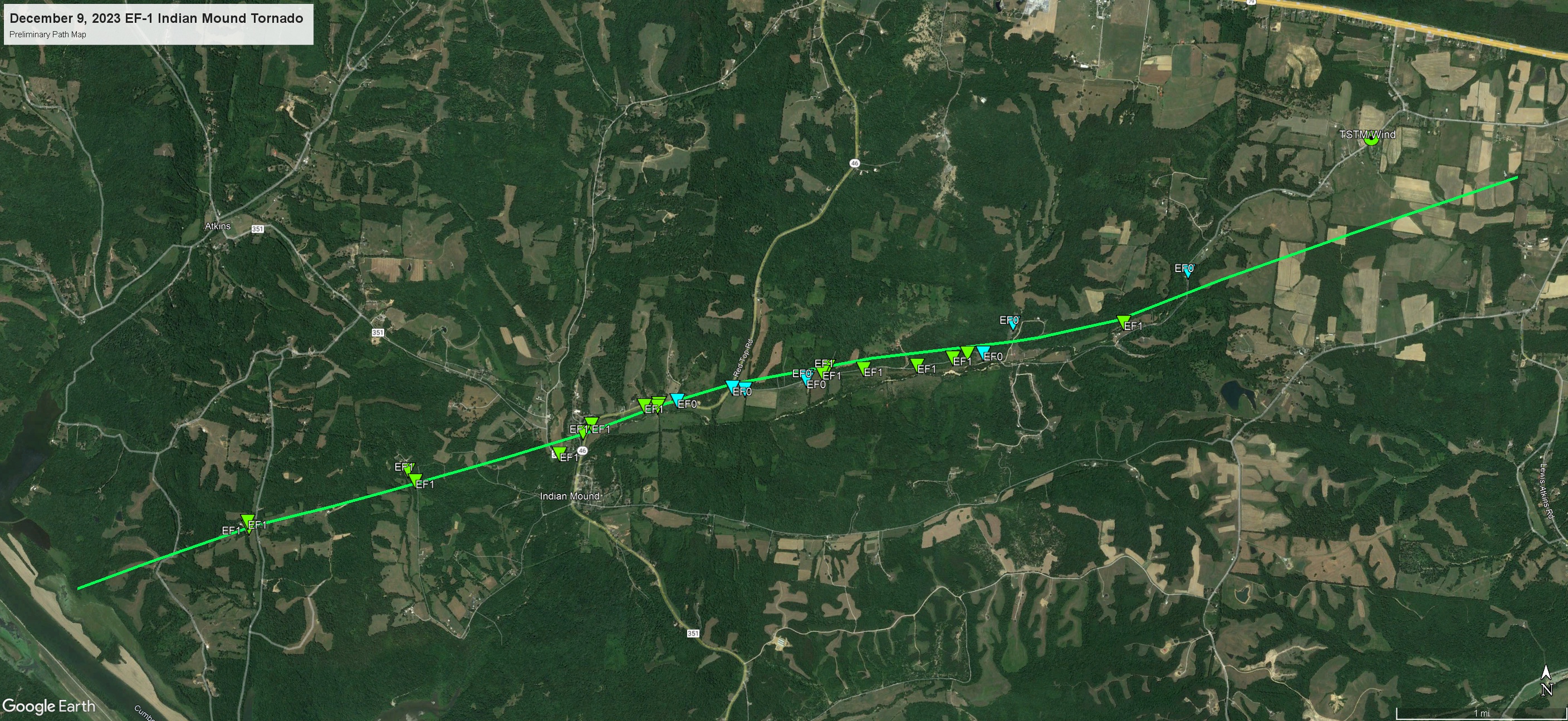 
|
||||||||||||||||
|
Tornado #2 - Clarksville, TN
Track Map 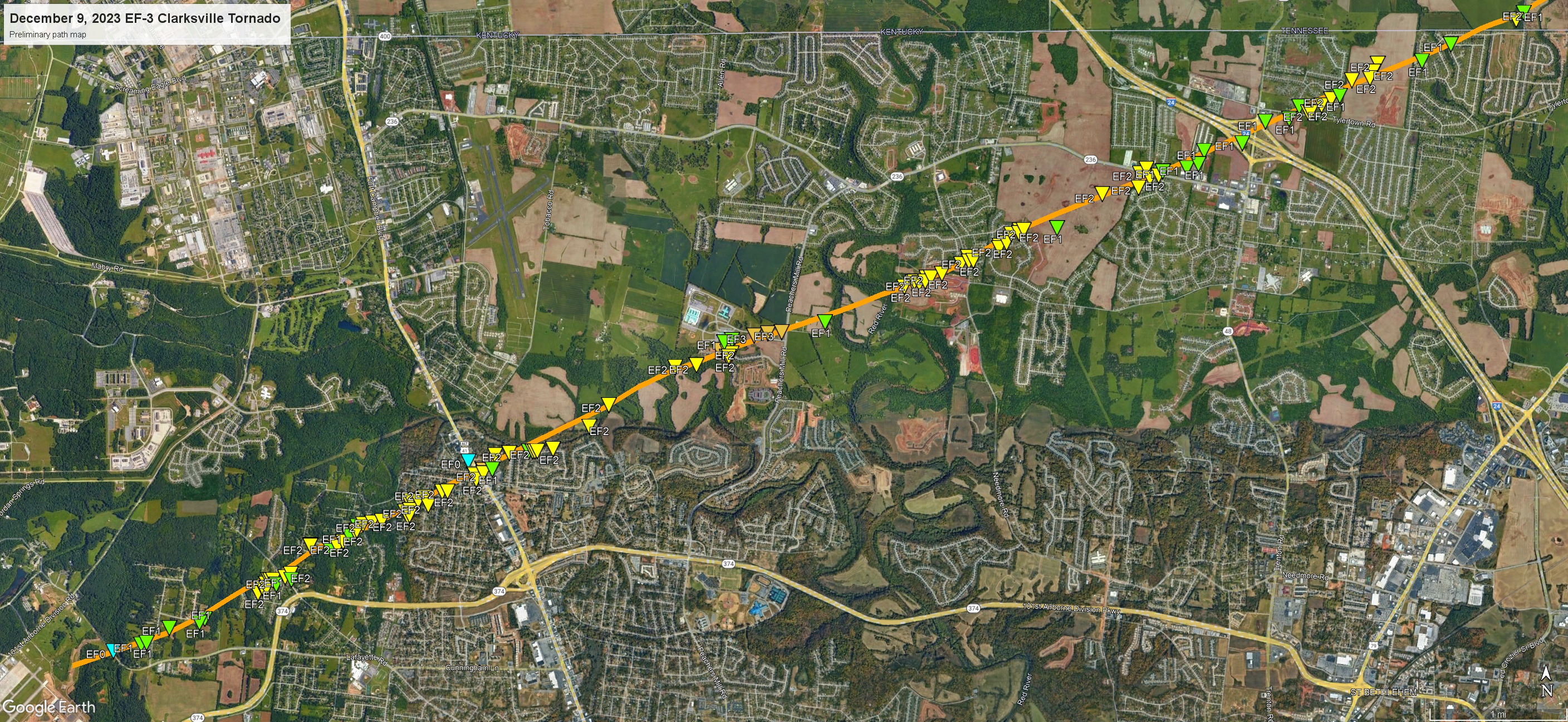 
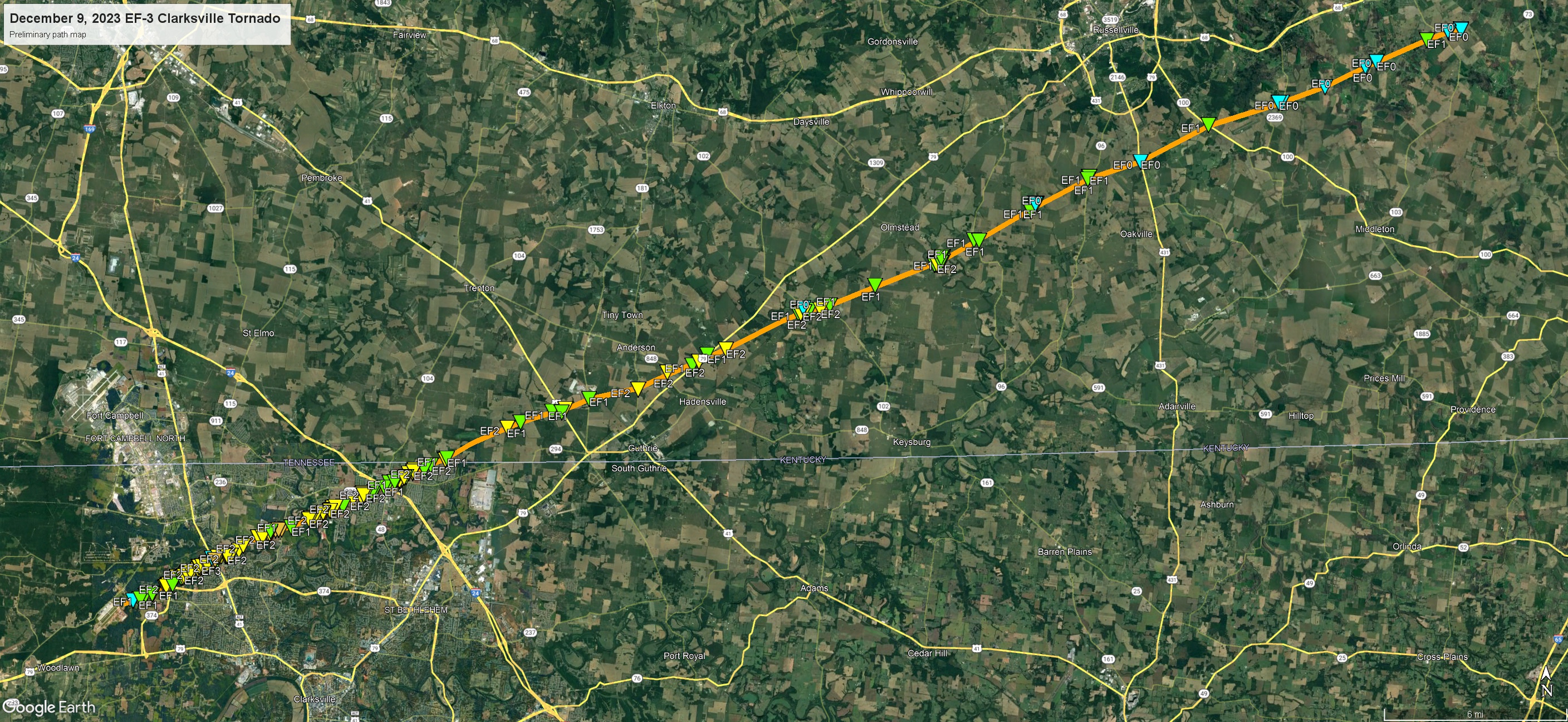  |
||||||||||||||||
|
Tornado #3 - Cumberland Furnace, TN
Track Map 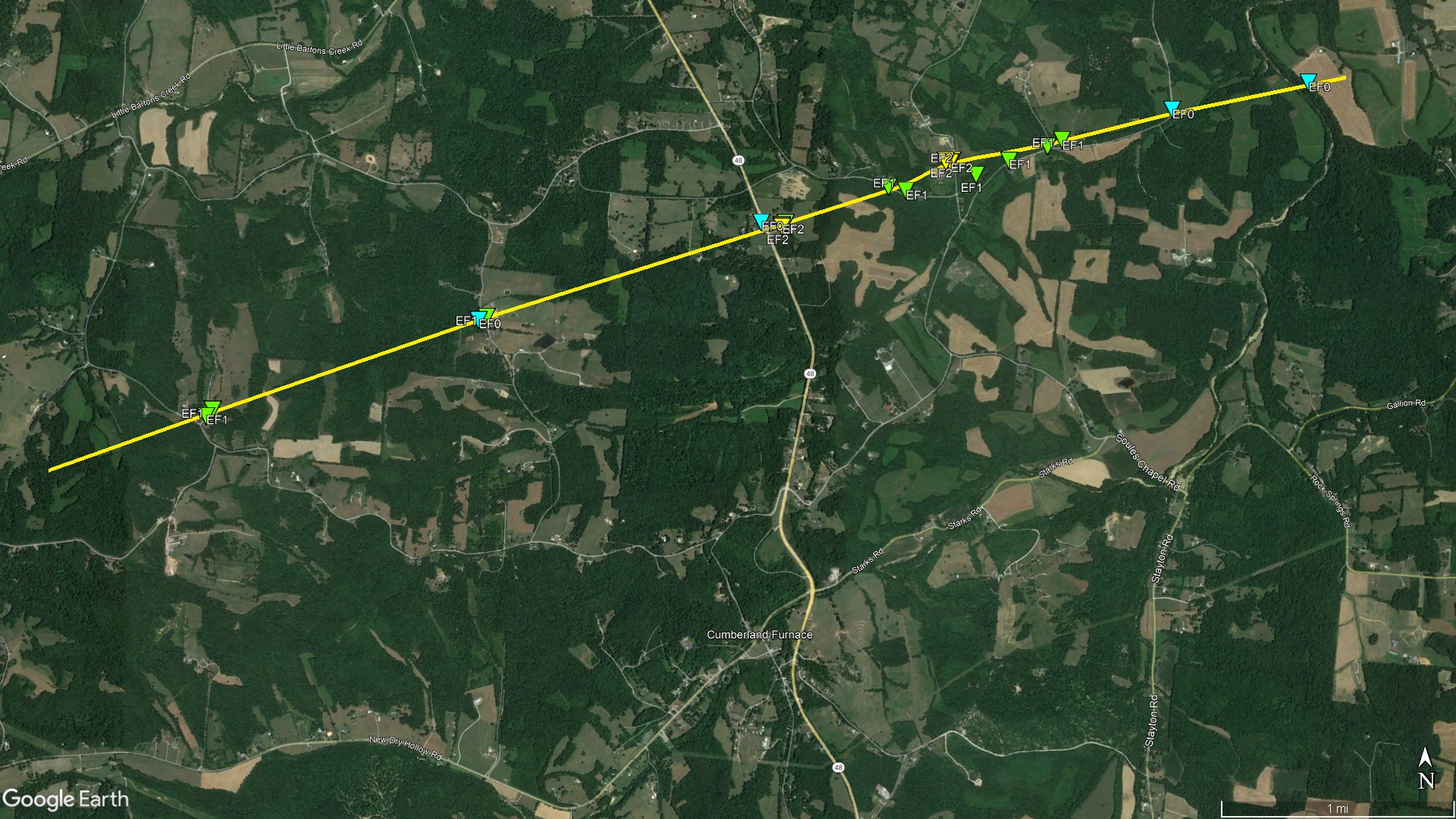 
|
||||||||||||||||
|
Tornado #4 - White Bluff, TN
Track Map 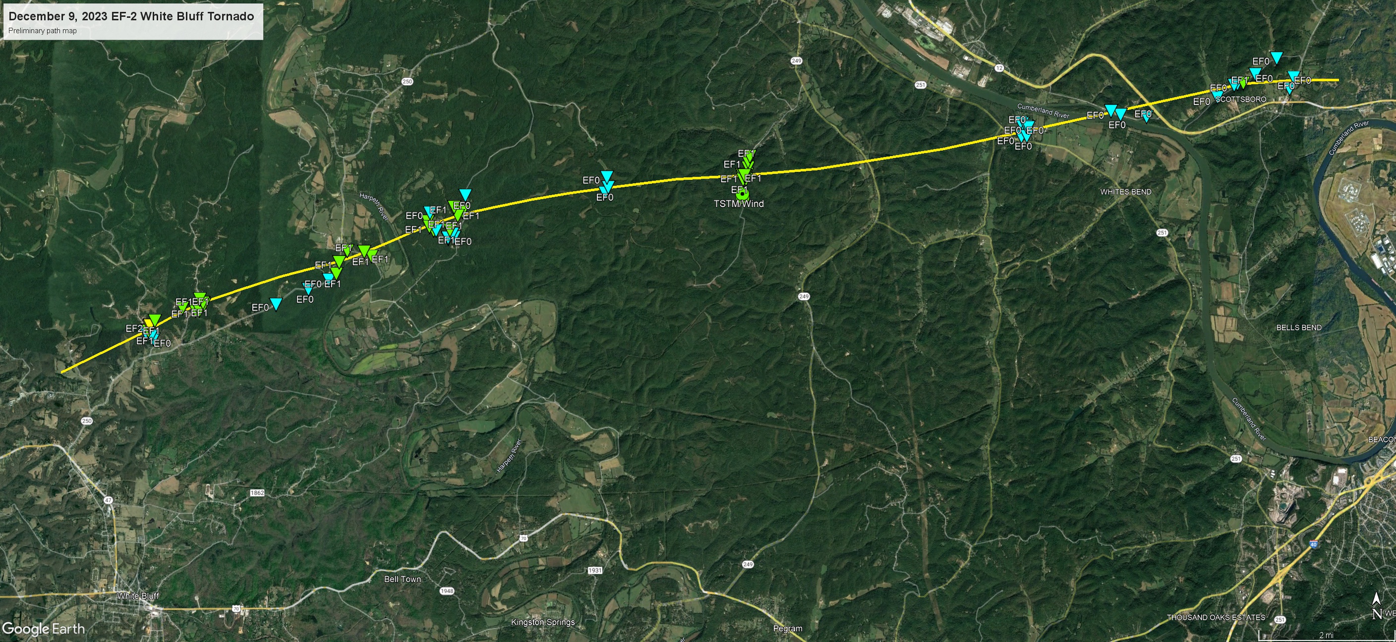 
|
||||||||||||||||
|
Tornado #5 - Springfield, TN
Track Map 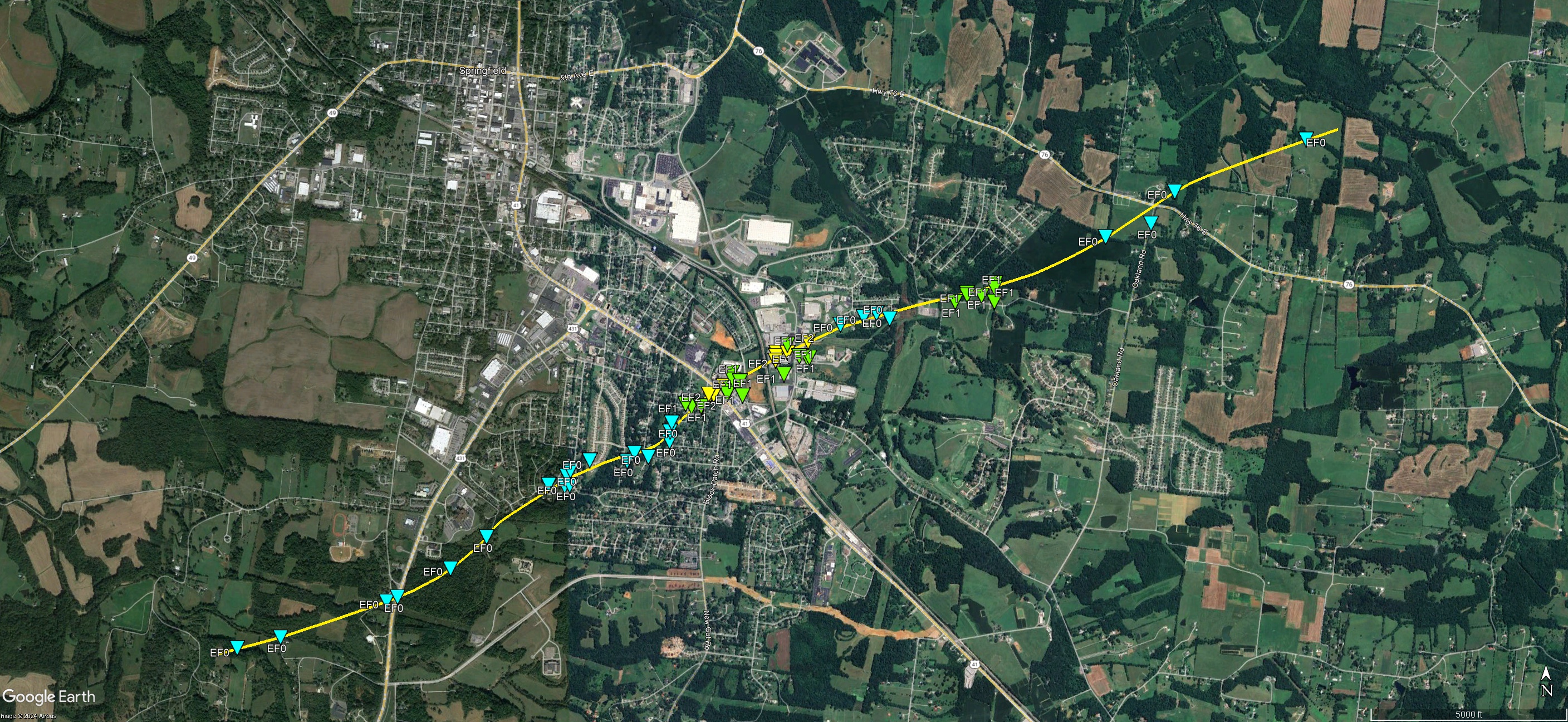 
|
||||||||||||||||
|
Tornado #6 - Madison / Hendersonville / Gallatin
Track Map 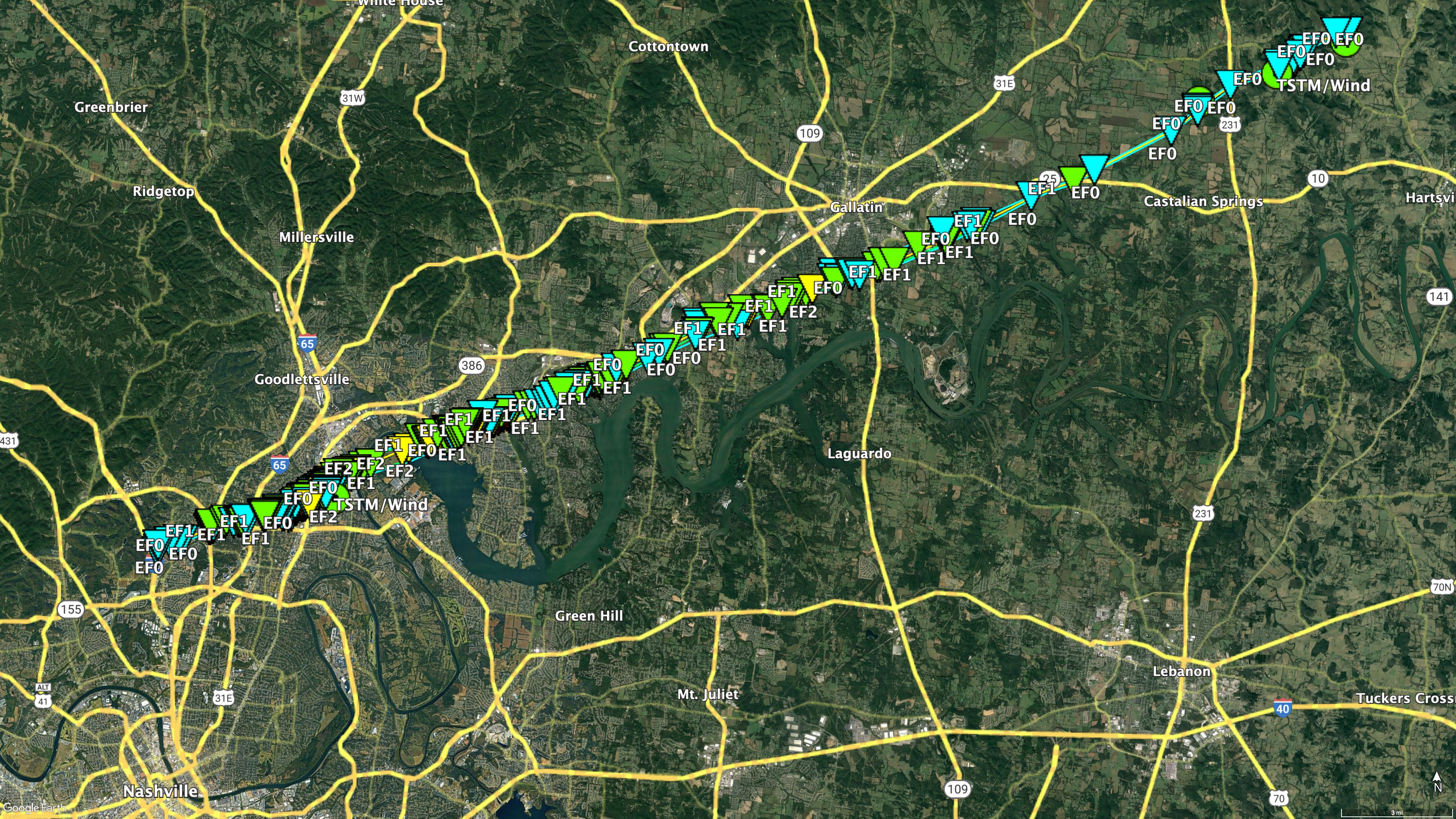 
|
||||||||||||||||
|
Tornado #7 - Harlan Crossroads KY
Track Map
|
||||||||||||||||
The Enhanced Fujita (EF) Scale classifies tornadoes into the following categories:
| EF0 Weak 65-85 mph |
EF1 Moderate 86-110 mph |
EF2 Significant 111-135 mph |
EF3 Severe 136-165 mph |
EF4 Extreme 166-200 mph |
EF5 Catastrophic 200+ mph |
 |
|||||
Damage Surveys
Click here for a KML map of damage surveys (updated 10 AM CST on 12/22/2023)
Public Information Statement...UPDATED
National Weather Service Nashville TN
958 AM CST Wed Dec 20 2023

...NWS Damage Survey for 12/09/23 Tornado Event - Update #9...

.Update...In collaboration with NWS Louisville Kentucky, the
Clarksville, TN tornado track has now been extended further into
Kentucky, bringing the total path length to 47.75 miles. Further,
a fourth fatality was reported in Clarksville and that has been
added to the information below. At this time, no additional
damage reports have been received in the NWS Nashville forecast
area and there is not another planned update to this damage
information.

.Overview...A strong storm system moved through Middle TN on
Saturday afternoon December 9, 2023, producing 7 tornadoes in
Middle TN. Additional tornadoes occurred across West TN, southern
KY, MS, and AL.

.Indian Mound EF-1 Tornado...

Rating:                 EF1
Estimated Peak Wind:    110 mph
Path Length /statute/:  7.31 miles
Path Width /maximum/:   75 yards
Fatalities:             0
Injuries:               0

Start Date:             12/09/2023
Start Time:             01:20 PM CST
Start Location:         5 ENE Dover / Stewart County / TN
Start Lat/Lon:          36.495 / -87.7428

End Date:               12/09/2023
End Time:               01:30 PM CST
End Location:           9 N Cumberland City / Montgomery County / TN
End Lat/Lon:            36.5211 / -87.6158

Survey Summary:
The tornado first touched down just east of the Cumberland River
near Cross Creeks National Wildlife Refuge off of Commissary
Hollow Road. Minor damage was observed to trees with a home
sustaining significant roof damage.  the tornado continued east-
northeast where dozens more trees were snapped and uprooted along
Lower Cross Creek Road.  Once the tornado entered Indian Mound,
more trees were either uprooted or snapped along Highway 46.  The
tornado then intensified on Red Top Road and Gillum Hollow Road
where a church overhang awning and greenhouses were damaged.  A
few more barns and outbuildings were damaged along Gillum Hollow
Road with several instances of uprooted and snapped trees along
its path including a tree falling onto a residence. The tornado
finally began to weaken as it entered into far western portions
of Montgomery County where only a few large branches were broken.
The tornado then lifted near Indian Mound Road and Liverpool
Road.

.Clarksville...

Rating:                 EF3
Estimated Peak Wind:    150 mph
Path Length /statute/:  47.75 miles
Path Width /maximum/:   600 yards
Fatalities:             4
Injuries:               62

Start Date:             12/09/2023
Start Time:             01:41 PM CST
Start Location:         5 S Fort Campbell North / Montgomery County / TN
Start Lat/Lon:          36.5746 / -87.4718

End Date:               12/09/2023
End Time:               02:49 PM CST
End Location:           2 SE Auburn / Simpson County / KY
End Lat/Lon:            36.8452 / -86.683

Survey Summary:
This EF-3 tornado first touched down on Fort Campbell just north
of the Sabre Airfield with mostly minor tree damage. It quickly
intensified as crossed Walnut Grove Road and destroyed a building
next to a church. The tornado then continued northeast and
damaged dozens of homes in a neighborhood along Garrettsburg Road
near Purple Heart Highway. The tornado then went through a
heavily wooded neighborhood south of Britton Springs Road where
dozens of mobile and manufactured homes were destroyed. The
tornado crossed into another neighborhood causing heavy damage in
and near Eva Drive, with several houses shifted off their
foundations that were only attached with straight nails
(EF2/120mph). The tornado intensified to EF-3 (140 mph) as it
crossed Highway 41 and struck several commercial businesses,
including a vacant fast food restaurant and strip mall where only
the interior remained. Just east of Highway 41 north of Ringgold
Road, another neighborhood was struck with several homes
sustaining significant damage. As the tornado continued
northeast, it strengthened further to EF-3 (150mph), destroying
four two story brick and vinyl siding homes on Henry Place Blvd.
Debris was blown across the field towards West Creek Elementary
School where the school sustained roof damage. As the tornado
crossed Peachers Mill Road, two dozen brand new two story brick
apartment homes were severely damaged with roofs missing on at
least a dozen of these structures. Dozens more houses suffered
significant roof damage along and near Needmore Road and Tiny
Town Rd (EF-2). The tornado then crossed I-24 at Trenton Road
where numerous cedar trees were uprooted. Continuing across
Tylertown Road, the tornado caused EF-1 to EF-2 damage roof and
siding damage to dozens of homes across 3 neighborhoods before
moving into Kentucky. A total of nearly 1000 homes were impacted
by the tornado, including 114 homes destroyed and 268 homes with
major damage, with 3 people killed and 62 injured.

.Cumberland Furnace EF-2 Tornado...

Rating:                 EF2
Estimated Peak Wind:    125 mph
Path Length /statute/:  5.83 miles
Path Width /maximum/:   300 yards
Fatalities:             0
Injuries:               2

Start Date:             12/09/2023
Start Time:             03:29 PM CST
Start Location:         3 ESE Slayden / Dickson County / TN
Start Lat/Lon:          36.2793 / -87.4138

End Date:               12/09/2023
End Time:               03:39 PM CST
End Location:           8 N Charlotte / Dickson County / TN
End Lat/Lon:            36.3029 / -87.3137

Survey Summary:
This EF-2 tornado touched down southwest of the intersection of
Woods Valley Road and Bone Road, then moved east-northeast where
it snapped a few pine trees and caused roof damage to a home.
Continuing east-northeast, the tornado damaged a mobile home and
outbuilding on Gamble Hollow Road. The tornado intensified to EF-
2 as it crossed Highway 48, causing the most significant damage
along its path as it completely removed the top level of a home,
leaving only the lower exterior walls in place. Winds were
estimated at 125 mph in this area. The tornado maintained its
strength as it continued toward Freeman Loop, striking an A-frame
house and ripping off the top half of the home. As it continued
eastward, the tornado did substantial damage to another mobile
home and snapped and uprooted dozens of trees along Freeman Loop
before finally lifting after crossing Barton's Creek.

.White Bluff EF-2 Tornado...

Rating:                 EF2
Estimated Peak Wind:    125 mph
Path Length /statute/:  19.31 miles
Path Width /maximum/:   700 yards
Fatalities:             0
Injuries:               2

Start Date:             12/09/2023
Start Time:             04:03 PM CST
Start Location:         4 NNW White Bluff / Dickson County / TN
Start Lat/Lon:          36.1601 / -87.2335

End Date:               12/09/2023
End Time:               04:27 PM CST
End Location:           7 WNW Nashville / Davidson County / TN
End Lat/Lon:            36.2162 / -86.9066

Survey Summary:
The tornado touched down in the Claylick community in eastern
Dickson County snapping and uprooting several trees and
destroying an outbuilding. It quickly intensified to low end EF-
2 strength as it crossed Nosegay Road and demolished a single
story manufactured home. The tornado continued to Pack Annex Road
where it did minor damage to the tops of high-tension power lines
and continued to snap large trees as it moved northeast into
Cheatham County. Uprooted trees and minor roof damage occurred in
the Griffintown area of Cheatham County. The tornado weakened and
caused sporadic tree damage as it moved into Cheatham Wildlife
Management Area. It strengthened once more, causing prolific tree
damage and structure damage to homes along Dry Creek Road south
of Ashland City. Just before leaving Cheatham county, the tornado
caused minor outbuilding damage and snapped a few trees near
River Road. At this point, the tornado crossed in Davidson county
and crossed the Cumberland River. On Pecan Valley road, some
structural damage was observed, but damage was consistent with
weakening tornado (EF-1/90 mph). The tornado lifted after
crossing Old Hickory Blvd, just north of Ashland City Highway.

.Springfield EF-2 Tornado...

Rating:                 EF2
Estimated Peak Wind:    120 mph
Path Length /statute/:  3.52 miles
Path Width /maximum/:   300 yards
Fatalities:             0
Injuries:               4

Start Date:             12/09/2023
Start Time:             04:19 PM CST
Start Location:         1 S Springfield / Robertson County / TN
Start Lat/Lon:          36.4784 / -86.883

End Date:               12/09/2023
End Time:               04:24 PM CST
End Location:           3 E Springfield / Robertson County / TN
End Lat/Lon:            36.4993 / -86.8261

Survey Summary:
This EF-2 tornado touched down near Fairway Trail and Kemper Court
in southern Springfield. Moving northeast, the tornado snapped and
uprooted trees along many residential streets and caused minor
damage to a few homes. More significant damage to homes occurred
further northeast on Rudolph Street and Brentlawn Drive. The
tornado strengthened as it crossed Highway 41 near the Kroger
shopping center, with numerous businesses damaged from high-end
EF1 to low-end EF2 intensity (110-115 mph). 25 vehicles in the
Kroger parking lot were flipped with some thrown into nearby
ditches. The tornado then crossed the railroad tracks behind
Kroger and reached its peak intensity as it entered an industrial
area, where multiple warehouse structures were heavily damaged.
With the majority of these metal building systems having Grade 5
bolts holding down the columns, winds were estimated at EF-2/120
mph in this area. The tornado then struck a fire department and
strip mall (EF-1/110 mph) and bent a steel transmission pole at a
power substation (EF-2/115 mph) on the east side of the
industrial park. As the tornado continued northeast, it
significantly weakened but still uprooted trees and caused minor
roof damage to homes on Greystone Drive and Sloan Lane. On Roy
Pitt Road, the tornado destroyed a two car garage and rolled a
trailer on its side (EF-1). The tornado finally lifted near the
intersection of Oakland Road and Highway 76E.

.Davidson/Sumner/Trousdale EF-2 Tornado...

Rating:                 EF2
Estimated Peak Wind:    130 mph
Path Length /statute/:  35.23 miles
Path Width /maximum/:   600 yards
Fatalities:             3
Injuries:               22

Start Date:             12/09/2023
Start Time:             04:39 PM CST
Start Location:         5 N Nashville / Davidson County / TN
Start Lat/Lon:          36.255 / -86.7852

End Date:               12/09/2023
End Time:               05:31 PM CST
End Location:           5 NW Hartsville / Trousdale County / TN
End Lat/Lon:            36.4567 / -86.2129

Survey Summary:
This strong EF-2 tornado touched down just to the east of I-24
west of Brick Church Lane. There were a few trees down and
shingle damage to several homes in this area. The tornado
strengthened in the Madison area causing EF-2 damage with winds up
to 120-125 mph. The heaviest damage was confined to two areas,
off of East Campbell Road as well as Nesbitt Lane. Multiple mobile
homes were destroyed on Nesbitt Lane. This is where 3 fatalities
occurred. Multiple single family homes and a church off of East
Campbell Road were missing large sections of their roofs, with
some exterior walls collapsed. Several metal power poles in the
area were bent as well. Nearby, an apartment complex off Palmer
Avenue sustained damage. As the tornado moved further northeast,
substantial damage was found to houses in a cul-de-sac on Stoney
River Lane. Two buildings were toppled and several others damaged
in an industrial complex off of Myatt Drive. The tornado then
continued across the Cumberland River and Old Hickory Lake, coming
onshore again in the immediate dam vicinity. It is this location
in which the strongest winds were found, up to 130 miles per hour,
due to substantial damage to a grove of hundreds of trees in
which all of them were either snapped, uprooted, or missing major
branches. The tornado persisted into Hendersonville downing
hundreds of trees and causing roof damage to multiple homes. It
damaged many businesses along Main Street. The tornado continued
northeast into Gallatin where EF-2 (115 mph) damage was found to a
few homes in The Club at Foxland Harbor as we as the Foxland
Harbor Golf and Country Club. At this point, the tornado began to
weaken, though EF-1 damage was found as it crossed Hwy 109 and
Steam Plant Road. Several trees were still found to be uprooted,
along with minor roof and shingle damage to a couple of homes as
the tornado crossed Hartsville Pike. Scattered trees continued to
be blown down along Lauderdale Lane and Homer Scott Road before
the tornado crossed Highway 231 into Trousdale County. Trees
continued to be blown down on Browning Branch Road and a home
suffered significant roof and porch damage on Hawkins Branch Road.
Trees continued to be blown down until the tornado lifted near
Shephard Hollow Lane. Around 600 homes/businesses were damaged in
Sumner County.

.Harlan Crossroads KY EF-1 Tornado...

Rating:                 EF1
Estimated Peak Wind:    90 mph
Path Length /statute/:  2.51 miles
Path Width /maximum/:   50 yards
Fatalities:             0
Injuries:               0

Start Date:             12/09/2023
Start Time:             06:07 PM CST
Start Location:         3 SSW Harlan Crossroads / Clay County / TN
Start Lat/Lon:          36.6169 / -85.723

End Date:               12/09/2023
End Time:               06:11 PM CST
End Location:           1 WNW Boles / Monroe County / KY
End Lat/Lon:            36.6308 / -85.683

Survey Summary:
A brief EF-1 tornado touched down just south of the Kentucky
border in Clay County where it blew down a few trees on Barber
Shop Road (EF-0). The tornado intensified to EF-1 as it moved
northeast into Kentucky and caused significant roof and siding
damage to several chicken barns on Harlans Crossroads. A home
also lost its porch and part of its roof on Red Hill-Beech Grove
Road. A few more trees were blown down west of Beech Groves-Boles
Road before the tornado lifted.

&&

EF Scale: The Enhanced Fujita Scale classifies tornadoes into the
following categories:

EF0.....65 to 85 mph
EF1.....86 to 110 mph
EF2.....111 to 135 mph
EF3.....136 to 165 mph
EF4.....166 to 200 mph
EF5.....>200 mph

NOTE:
The information in this statement is preliminary and subject to
change pending final review of the event and publication in
NWS Storm Data.

$$
Local Storm Reports
Preliminary Local Storm Report...Summary
National Weather Service Nashville TN
348 PM CST Wed Dec 20 2023

..TIME...   ...EVENT...      ...CITY LOCATION...     ...LAT.LON...
..DATE...   ....MAG....      ..COUNTY LOCATION..ST.. ...SOURCE....
            ..REMARKS..

0120 PM     Tornado          6 E Dover               36.49N 87.74W
12/09/2023                   Stewart            TN   NWS Storm Survey

            The tornado first touched down just east of
            the Cumberland River near Cross Creeks
            National Wildlife Refuge off of Commissary
            Hollow Road. Minor damage was observed to
            trees with a home sustaining significant
            roof damage. the tornado continued
            east-northeast where dozens more trees were
            snapped and uprooted along Lower Cross Creek
            Road. Once the tornado entered Indian Mound,
            more trees were either uprooted or snapped
            along Highway 46. The tornado then
            intensified on Red Top Road and Gillum
            Hollow Road where a church overhang awning
            and greenhouses were damaged. A few more
            barns and outbuildings were damaged along
            Gillum Hollow Road with several instances of
            uprooted and snapped trees along its path
            including a tree falling onto a residence.
            The tornado finally began to weaken as it
            entered into far western portions of
            Montgomery County where only a few large
            branches were broken. The tornado then
            lifted near Indian Mound Road and Liverpool
            Road.

0141 PM     Tornado          3 NNE Woodlawn          36.58N 87.47W
12/09/2023                   Montgomery         TN   NWS Storm Survey

            *** 4 FATAL, 62 INJ ***
            This major EF-3 tornado first touched down
            on Fort Campbell just north of the Sabre
            Airfield with mostly minor tree damage. It
            quickly intensified as crossed Walnut Grove
            Road and destroyed a building next to a
            church. The tornado then continued northeast
            and damaged dozens of homes in a
            neighborhood along Garrettsburg Road near
            Purple Heart Highway. The tornado then went
            through a heavily wooded neighborhood south
            of Britton Springs Road where dozens of
            mobile and manufactured homes were
            destroyed. The tornado crossed into another
            neighborhood causing heavy damage in and
            near Eva Drive, with several houses shifted
            off their foundations that were only
            attached with straight nails. The tornado
            intensified to EF-3 as it crossed Highway 41
            and struck several commercial businesses,
            including a vacant fast food restaurant and
            strip mall where only the interior remained.
            Just east of Highway 41 to the north of
            Ringgold Road, another neighborhood was
            struck with several homes sustaining
            significant damage. As the tornado continued
            northeast it strengthened further,
            destroying four two story brick and vinyl
            siding homes on Henry Place Blvd. Debris was
            blown across the field towards West Creek
            Elementary School where the school sustained
            roof damage. As the tornado crossed Peachers
            Mill Road, two dozen brand new two story
            brick apartment homes were severely damaged
            with roofs missing on at least a dozen of
            these structures. Dozens more houses
            suffered significant roof damage along and
            near Needmore Road and Tiny Town Rd (EF-2).
            The tornado then crossed I-24 at Trenton
            Road where numerous cedar trees were
            uprooted. Continuing across Tylertown Road,
            the tornado caused EF-1 to EF-2 damage roof
            and siding damage to dozens of homes across
            3 neighborhoods before moving into Kentucky.
            A total of nearly 1000 homes were impacted
            by the tornado, including 114 homes
            destroyed and 268 homes with major damage,
            with 4 people killed and 62 injured. Path
            length in TN of 11.3 miles, but total path
            length of 47.75 miles.

0329 PM     Tornado          3 NW Cumberland Furnace 36.30N 87.39W
12/09/2023                   Dickson            TN   NWS Storm Survey

            *** 1 INJ ***
            This EF-2 tornado touched down southwest of
            the intersection of Woods Valley Road and
            Bone Road, then moved east-northeast where
            it snapped a few pine trees and caused roof
            damage to a home. Continuing east-northeast,
            the tornado damaged a mobile home and
            outbuilding on Gamble Hollow Road. The
            tornado intensified to EF-2 as it crossed
            Highway 48, causing the most significant
            damage along its path as it completely
            removed the top level of a home, leaving
            only the lower exterior walls in place.
            Winds were estimated at 125 mph in this
            area. The tornado maintained its strength as
            it continued toward Freeman Loop, striking
            an A-frame house and ripping off the top
            half of the home. As it continued eastward,
            the tornado did substantial damage to
            another mobile home and snapped and uprooted
            dozens of trees along Freeman Loop before
            finally lifting after crossing Bartons
            Creek.

0357 PM     Hail             1 SE Charlotte          36.18N 87.34W
12/09/2023  E1.25 inch       Dickson            TN   Public

            Estimated hail size from social media
            picture. Time estimated on radar.

0401 PM     Hail             5 SW Cedar Hill         36.50N 87.06W
12/09/2023  E0.75 inch       Robertson          TN   Public

            Report from mPING: Dime (0.75 in.).

0403 PM     Tornado          4 N White Bluff         36.16N 87.21W
12/09/2023                   Dickson            TN   NWS Storm Survey

            The tornado touched down in the Claylick
            community in eastern Dickson County snapping
            and uprooting several trees and destroying
            an outbuilding. It quickly intensified to
            low end EF-2 strength as it crossed Nosegay
            Road and demolished a single story
            manufactured home. The tornado continued to
            Pack Annex Road where it did minor damage to
            the tops of high-tension power lines and
            continued to snap large trees as it moved
            northeast into Cheatham County. Uprooted
            trees and minor roof damage occurred in the
            Griffintown area of Cheatham County. The
            tornado weakened and caused sporadic tree
            damage as it moved into Cheatham Wildlife
            Management Area. It strengthened once more,
            causing prolific tree damage and structure
            damage to homes along Dry Creek Road south
            of Ashland City. The tornado lifted after
            causing minor structure damage and snapping
            a few trees near River Road.

0419 PM     Tornado          Springfield             36.50N 86.88W
12/09/2023                   Robertson          TN   NWS Storm Survey

            *** 4 INJ ***
            This EF-2 tornado touched down near Fairway
            Trail and Kemper Court in southern
            Springfield. Moving northeast, the tornado
            snapped and uprooted trees along many
            residential streets and caused minor damage
            to a few homes. More significant damage to
            homes occurred further northeast on Rudolph
            Street and Brentlawn Drive. The tornado
            strengthened as it crossed Highway 41 near
            the Kroger shopping center, with numerous
            businesses damaged from high-end EF1 to
            low-end EF2 intensity (110-115 mph). 25
            vehicles in the Kroger parking lot were
            flipped with some thrown into nearby
            ditches. The tornado then crossed the
            railroad tracks behind Kroger and reached
            its peak intensity as it entered an
            industrial area, where multiple warehouse
            structures were heavily damaged. With the
            majority of these metal building systems
            having Grade 5 bolts holding down the
            columns, winds were estimated at EF-2/120
            mph in this area. The tornado then struck a
            fire department and strip mall (EF-1/110
            mph) and bent a steel transmission pole at a
            power substatation (EF-2/115 mph) on the
            east side of the industrial park. As the
            tornado continued northeast, it
            significantly weakened but still uprooted
            trees and caused minor roof damage to homes
            on Greystone Drive and Sloan Lane. On Roy
            Pitt Road, the tornado destroyed a two car
            garage and rolled a trailer on its side
            (EF-1). The tornado finally lifted near the
            intersection of Oakland Road and Highway
            76E.

0437 PM     Hail             6 WNW Madison           36.30N 86.81W
12/09/2023  E0.75 inch       Davidson           TN   Public

            Report from mPING: Dime (0.75 in.).

0439 PM     Tornado          4 W Madison             36.26N 86.79W
12/09/2023                   Davidson           TN   NWS Storm Survey

            *** 3 FATAL, 22 INJ ***
            This strong EF-2 tornado touched down just
            to the east of I-24 west of Brick Church
            Lane. There were a few trees down and
            shingle damage to several homes in this
            area. The tornado strengthened in the
            Madison area causing EF-2 damage with winds
            up to 120-125 mph. The heaviest damage was
            confined to two areas, off of East Campbell
            Road as well as Nesbitt Lane. Multiple
            mobile homes were destroyed on Nesbitt Lane.
            This is where 3 fatalities occurred.
            Multiple single family homes and a church
            off of East Campbell Road were missing large
            sections of their roofs, with some exterior
            walls collapsed. Several metal power poles
            in the area were bent as well. Nearby, an
            apartment complex off Palmer Avenue
            sustained damage. As the tornado moved
            further northeast, substantial damage was
            found to houses in a cul-de-sac on Stoney
            River Lane. Two buildings were toppled and
            several others damaged in an industrial
            complex off of Myatt Drive. The tornado then
            continued across the Cumberland River and
            Old Hickory Lake, coming onshore again in
            the immediate dam vicinity. It is this
            location in which the strongest winds were
            found, up to 130 miles per hour, due to
            substantial damage to a grove of hundreds of
            trees in which all of them were either
            snapped, uprooted, or missing major
            branches. The tornado persisted into
            Hendersonville downing hundreds of trees and
            causing roof damage to multiple homes. It
            damaged many businesses along Main Street.
            The tornado continued northeast into
            Gallatin where EF-2 (115 mph) damage was
            found to a few homes in The Club at Foxland
            Harbor as we as the Foxland Harbor Golf and
            Country Club. At this point, the tornado
            began to weaken, though EF-1 damage was
            found as it crossed Hwy 109 and Steam Plant
            Road. Several trees were still found to be
            uprooted, along with minor roof and shingle
            damage to a couple of homes as the tornado
            crossed Hartsville Pike. Scattered trees
            continued to be blown down along Lauderdale
            Lane and Homer Scott Road before the tornado
            crossed Highway 231 into Trousdale County.
            Trees continued to be blown down on Browning
            Branch Road and a home suffered significant
            roof and porch damage on Hawkins Branch
            Road. Trees continued to be blown down until
            the tornado lifted near Shephard Hollow
            Lane. Around 600 homes/businesses were
            damaged in Sumner County. Davidson and
            Sumner County EMAs indicate 21 people were
            injured in Davidson County, and 1 person was
            injured in Sumner County.

0515 PM     Tstm Wnd Gst     2 E Gallatin            36.38N 86.41W
12/09/2023  M67 MPH          Sumner             TN   AWOS

            AWOS station KXNX Gallatin Airport.

0550 PM     Hail             4 SE Bethpage           36.45N 86.27W
12/09/2023  E1.00 inch       Trousdale          TN   Public

            Estimated quarter size hail 1 mile north of
            TN-25 and US-231.

0601 PM     Tstm Wnd Dmg     7 NE Collinwood         35.25N 87.67W
12/09/2023                   Wayne              TN   Broadcast Media

            Tree down in yard of home reported by
            Tennessee Valley Weather. Location and time
            estimated.

0606 PM     Tornado          9 NE Red Boiling Spring 36.62N 85.72W
12/09/2023                   Clay               TN   NWS Storm Survey

            A brief EF-1 tornado touched down just south
            of the Kentucky border in Clay County where
            it blew down a few trees on Barber Shop
            Road. The tornado intensified as it moved
            northeast into Kentucky and caused
            significant roof and siding damage to
            several chicken barns on Harlans Crossroads.
            A home also lost its porch and part of its
            roof on Red Hill-Beech Grove Road. A few
            more trees were blown down west of Beech
            Groves-Boles Road before the tornado lifted.

0643 PM     Tstm Wnd Dmg     4 SE Loretto            35.04N 87.39W
12/09/2023                   Lawrence           TN   Public

            Tree down on car on 1100 block of Lexington
            Highway southeast of Loretto.

0812 PM     Hail             2 NNW Tullahoma         35.40N 86.23W
12/09/2023  E1.00 inch       Coffee             TN   Broadcast Media

            Photo received of quarter-sized hail along
            Riley Creek Road between Normandy Lake and
            Tullahoma. Time is radar estimated.

0812 PM     Tstm Wnd Dmg     3 NNW Tullahoma         35.41N 86.24W
12/09/2023                   Coffee             TN   Emergency Mngr

            A few trees down along Normandy road. Time
            is radar estimated.

0825 PM     Hail             1 N Manchester          35.48N 86.08W
12/09/2023  E0.70 inch       Coffee             TN   Emergency Mngr

            Dime size hail reported in Manchester. Time
            is radar estimated.


&&

$$

NWS Nashville
December Tornado Stats
December tornado stats for Middle Tennessee
Stewart County
Montgomery County
Robertson County
Dickson County
Cheatham County
Davidson County
Sumner County
 |
Media use of NWS Web News Stories is encouraged! Please acknowledge the NWS as the source of any news information accessed from this site. |
 |