December 22-27, 2022 Arctic Cold Wave
|
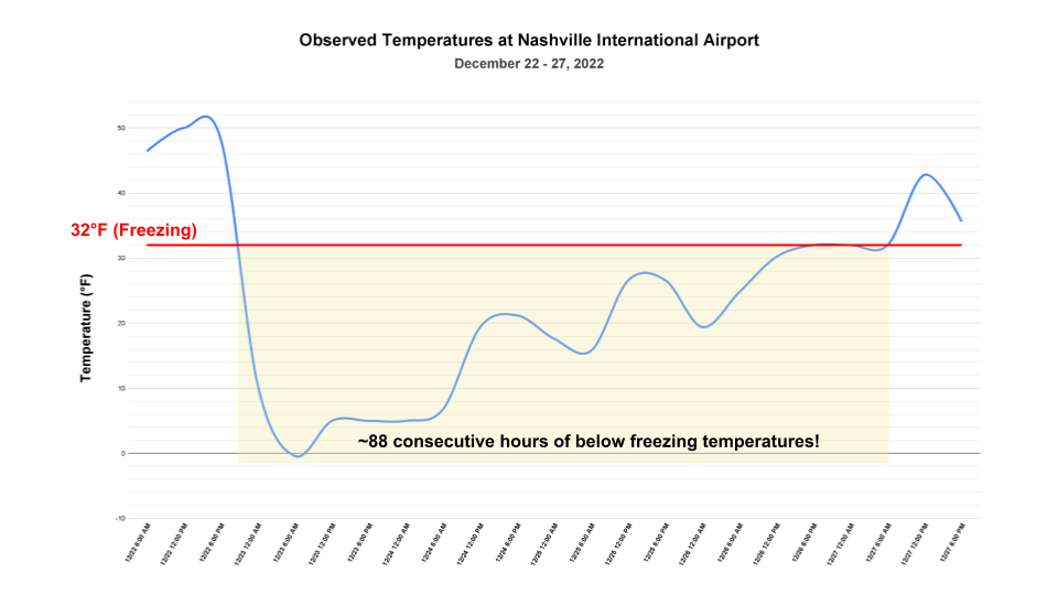
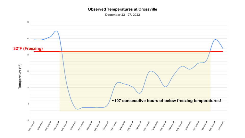
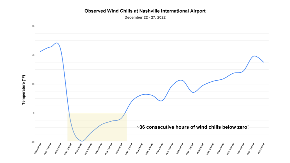
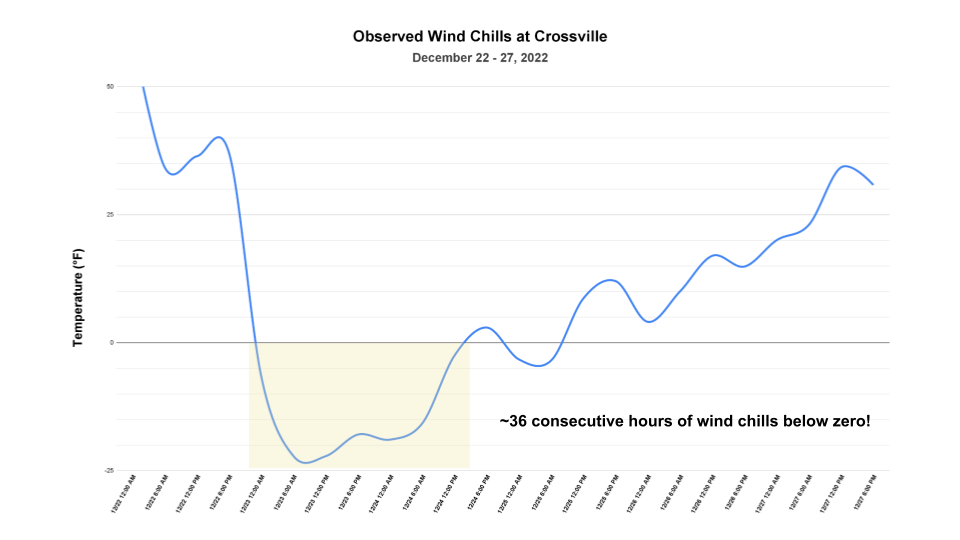
An abnormally strong and cold upper-level low pressure system plunged southward through much of the central and eastern United States, bringing a blast of Arctic air. These historically cold temperatures impacted all of Middle Tennessee beginning late on December 22, 2022. As the Arctic front swept eastward through the area, temperatures plummeted with low temperatures on the morning of December 23rd in the single digits and even below zero. This front also brought strong winds, and the combination of very cold air and strong winds resulted in brutal wind chills with values of -15 degrees to -30 degrees common areawide through December 24th. While snow was observed with this system, it did not last long and snow accumulations of only 1 to 2 inches was found approximately in areas north of Interstate 40. However, this snow resulted in significant impacts by early December 23rd with numerous traffic accidents and road closures reported. |
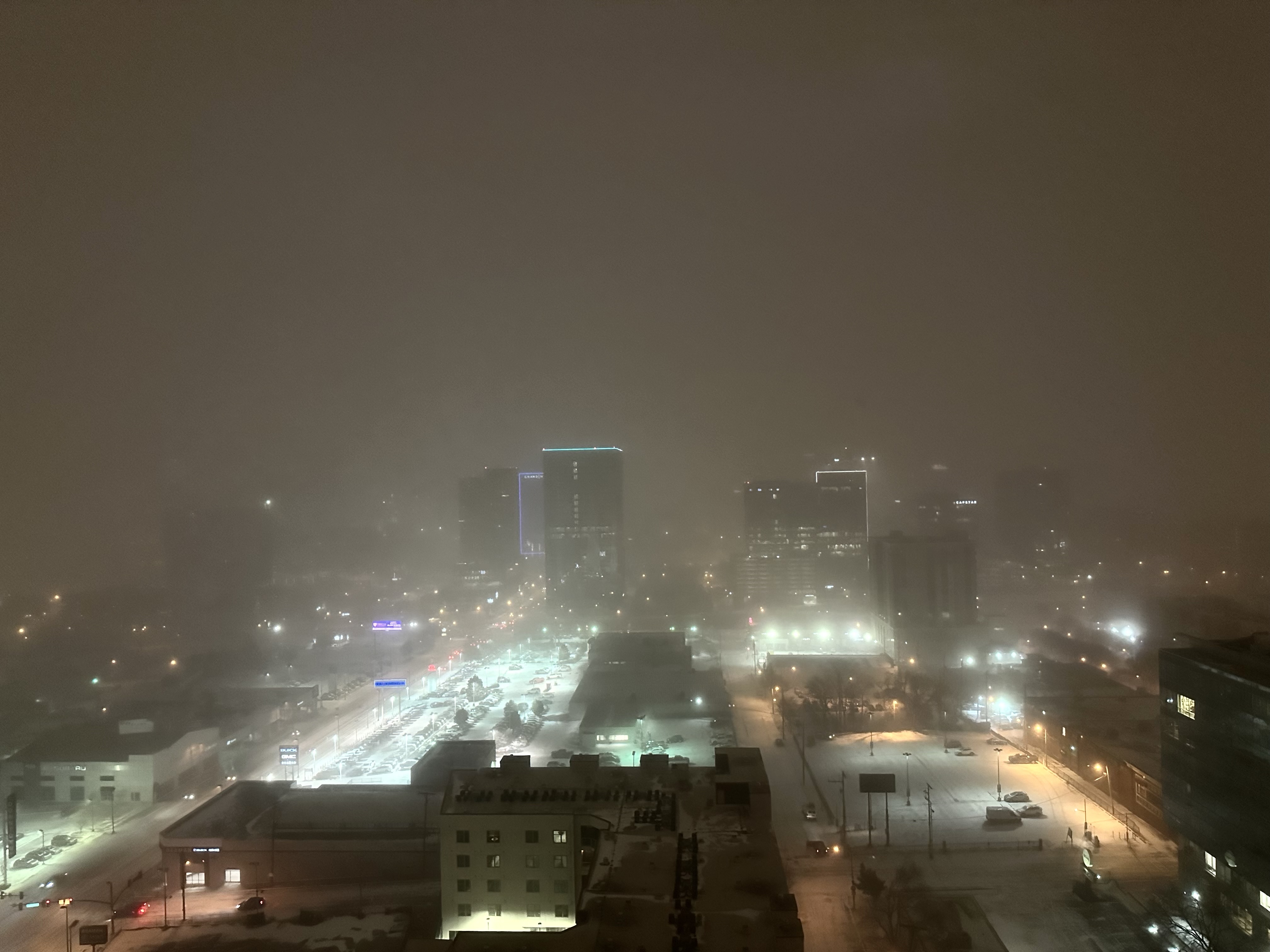 Cold and snow-covered downtown Nashville on the night of December 22, 2022 |
Temperatures
|
|
Public Information Statement
National Weather Service Nashville TN
709 AM CST Sat Dec 24 2022

...LOW TEMPERATURE REPORTS FROM THE MORNING OF DECEMBER 23RD...

Location                     Temp      Time/Date       Provider

...Tennessee...

...Bedford County...
Shelbyville                   -3 F     0755 AM 12/23   DAVIS
Shelbyville Bomar Field       -2 F     0715 AM 12/23   AWOS
Shelbyville                   -1 F     0915 AM 12/23   DAVIS
Shelbyville                   -1 F     0820 AM 12/23   CWOP

...Cannon County...
Short Mountain                -8 F     0909 AM 12/23   CWOP
Woodbury                      -3 F     0929 AM 12/23   CWOP
Bradyville                    -3 F     0750 AM 12/23   CWOP
Woodbury                      -1 F     0915 AM 12/23   CWOP

...Cheatham County...
2 SSE Kingston Springs        -6 F     0735 AM 12/23   AWS
Pegram                        -4 F     0736 AM 12/23   CWOP
Kingston Springs              -4 F     0715 AM 12/23   CWOP

...Coffee County...
Tullahoma Regional Airport    -2 F     0755 AM 12/23   AWOS
Franklin                      -1 F     0900 AM 12/23   CWOP
Manchester                    -1 F     0716 AM 12/23   CWOP
Manchester                    -1 F     0840 AM 12/23   DAVIS
Tullahoma                      0 F     0734 AM 12/23   CWOP

...Cumberland County...
Fairfield Glade               -4 F     0815 AM 12/23   CWOP
Crossville Memorial Airport   -4 F     1153 PM 12/23   ASOS
Crossville                    -3 F     0935 AM 12/23   CWOP
Culleoka                      -2 F     0933 AM 12/23   CWOP
Crossville                    -2 F     1045 AM 12/23   CWOP

...Davidson County...
Belle Meade                   -5 F     0819 AM 12/23   AWS
2 W Nashville                 -5 F     0848 AM 12/23   AWS
Belle Meade                   -4 F     0825 AM 12/23   AWS
Nashville                     -3 F     0740 AM 12/23   CWOP
Vanderbilt University         -2 F     0820 AM 12/23   MESOWEST
Nashville                     -2 F     0815 AM 12/23   CWOP
Nolensville                   -2 F     0745 AM 12/23   CWOP
Nashville John Tune Airport   -2 F     0750 AM 12/23   AWOS
Nashville                     -1 F     0850 AM 12/23   DAVIS
Nashville                     -1 F     0719 AM 12/23   CWOP
Nashville Intl Airport        -1 F     1153 PM 12/23   ASOS
Nashville                      0 F     0825 AM 12/23   CWOP

...De Kalb County...
LIBERTY                       -2 F     0801 AM 12/23   CWOP

...Dickson County...
Vanleer                       -7 F     0800 AM 12/23   AWS
Burns                         -4 F     0706 AM 12/23   RAWS
Dickson                       -4 F     0735 AM 12/23   CWOP

...Fentress County...
Pickett State Forest          -6 F     0743 AM 12/23   RAWS

...Giles County...
Elkton Allen Farms             1 F     0800 AM 12/23   MESOWEST

...Grundy County...
Tracy City                    -3 F     0910 AM 12/23   CWOP

...Hickman County...
Lyles                         -4 F     0721 AM 12/23   CWOP
Pleasantville                 -3 F     0700 AM 12/23   CWOP
Centerville                   -2 F     0809 AM 12/23   CWOP

...Humphreys County...
New Johnsonville              -3 F     0745 AM 12/23   CWOP

...Lawrence County...
Lawrenceburg Airport          -2 F     0755 AM 12/23   AWOS
Lawrenceburg                  -1 F     0825 AM 12/23   CWOP
Leoma                         -1 F     0747 AM 12/23   CWOP

...Lewis County...
Meriwether Lewis State Park   -4 F     0622 AM 12/23   RAWS

...Macon County...
Lafayette Work Center         -4 F     0706 AM 12/23   RAWS

...Marshall County...
Lewisburg Ellington Airport   -2 F     0715 AM 12/23   AWOS
Chapel Hill                    0 F     0800 AM 12/23   DAVIS
Lewisburg                      1 F     0815 AM 12/23   DAVIS

...Maury County...
Culleoka                      -2 F     0730 AM 12/23   CWOP
Culleoka                      -2 F     0747 AM 12/23   CWOP
Columbia Airport              -2 F     0750 AM 12/23   AWOS
Columbia Cox Middle School    -1 F     0700 AM 12/23   MESOWEST
Columbia                      -1 F     0835 AM 12/23   DAVIS
MOUNT PLEASANT                -1 F     0745 AM 12/23   CWOP

...Montgomery County...
8 ESE Clarksville             -6 F     0720 AM 12/23   AWS
Fort Campbell                 -5 F     0615 AM 12/23   RAWS
Clarksville                   -4 F     0758 AM 12/23   CWOP
Clarksville Outlaw Field      -3 F     1152 PM 12/23   ASOS

...Overton County...
Livingston Airport            -6 F     0735 AM 12/23   AWOS

...Robertson County...
Pleasant View                 -5 F     0725 AM 12/23   CWOP
Springfield Airport           -4 F     0855 AM 12/23   AWOS

...Rutherford County...
Murfreeboro                   -2 F     0810 AM 12/23   CWOP
Smyrna                        -2 F     0748 AM 12/23   CWOP
Smyrna                        -2 F     0735 AM 12/23   CWOP
Murfreesboro                  -2 F     0813 AM 12/23   CWOP
Smyrna Airport                -2 F     1156 PM 12/23   AWOS
Lascassas                     -1 F     0845 AM 12/23   CWOP
Murfreesboro                  -1 F     0750 AM 12/23   CWOP
Murfreesboro Municipal Airpo   0 F     0955 AM 12/23   AWOS
Perrysburg                     4 F     1123 PM 12/23   CWOP

...Smith County...
Carthage                      -1 F     0815 AM 12/23   DAVIS

...Stewart County...
Dover Stilly Hollow           -5 F     0726 AM 12/23   RAWS
Dover                         -2 F     0820 AM 12/23   CWOP

...Sumner County...
2 NE White House              -6 F     0805 AM 12/23   AWS
Portland Municipal Airport    -4 F     0855 AM 12/23   AWOS
Gallatin                      -3 F     0744 AM 12/23   CWOP
West Paterson                 -3 F     0746 AM 12/23   CWOP
Gallatin                      -3 F     0826 AM 12/23   DAVIS
Gallatin Airport              -2 F     0755 AM 12/23   AWOS
Hendersonville                 0 F     0745 AM 12/23   CWOP

...Warren County...
Mcminnville Airport           -2 F     0830 AM 12/23   AWOS
Morrison                      -1 F     0805 AM 12/23   CWOP

...White County...
Sparta                        -2 F     0901 AM 12/23   CWOP
Sparta-Cookeville Airport     -2 F     0835 AM 12/23   AWOS

...Williamson County...
5 W Franklin                  -5 F     0800 AM 12/23   AWS
Fairview                      -5 F     0648 AM 12/23   CWOP
1 NW Franklin                 -5 F     0750 AM 12/23   AWS
3 ENE Fairview                -4 F     0715 AM 12/23   AWS
Spring Hill                   -3 F     0730 AM 12/23   CWOP
Eagleville                    -3 F     0735 AM 12/23   CWOP
Brentwood                     -3 F     0722 AM 12/23   CWOP
Thompsons Station             -2 F     0740 AM 12/23   CWOP
Spring Hill                   -2 F     0743 AM 12/23   CWOP
Spring Hill                   -2 F     0725 AM 12/23   CWOP
Brentwood                     -2 F     0745 AM 12/23   CWOP
Nolensville                    2 F     1111 PM 12/23   CWOP

...Wilson County...
Mt. Juliet                    -4 F     0759 AM 12/23   CWOP
Watertown                     -3 F     0726 AM 12/23   CWOP
4 NNW Lebanon                 -3 F     0845 AM 12/23   AWS
Mount Juliet                  -2 F     0819 AM 12/23   CWOP
Lebanon                       -2 F     0810 AM 12/23   CWOP
Watertown                     -2 F     0707 AM 12/23   CWOP
Watertown                     -1 F     0845 AM 12/23   CWOP

Observations are collected from a variety of sources with varying
equipment and exposures. We thank all volunteer weather observers
for their dedication. Not all data listed are considered official.

$$
Public Information Statement
National Weather Service Nashville TN
959 AM CST Sat Dec 24 2022

...LOW TEMPERATURE REPORTS FROM OVERNIGHT DECEMBER 23RD INTO THE MORNING OF DECEMBER 24TH...

Location                     Temp      Time/Date       Provider

...Tennessee...

...Bedford County...
Shelbyville                    3 F     1025 PM 12/23   DAVIS
Shelbyville Bomar Field        3 F     1015 PM 12/23   AWOS
Shelbyville                    5 F     1022 PM 12/23   CWOP
Shelbyville                    6 F     1230 AM 12/24   DAVIS

...Cannon County...
Short Mountain                -3 F     0239 AM 12/24   CWOP
Woodbury                       1 F     1039 PM 12/23   CWOP
Bradyville                     1 F     0530 AM 12/24   CWOP
Woodbury                       3 F     1231 AM 12/24   CWOP

...Cheatham County...
2 SSE Kingston Springs         2 F     0515 AM 12/24   AWS
Pegram                         3 F     0546 AM 12/24   CWOP
Kingston Springs               3 F     0355 AM 12/24   CWOP

...Coffee County...
Franklin                       3 F     0515 AM 12/24   CWOP
Manchester                     3 F     1101 PM 12/23   CWOP
Tullahoma Regional Airport     3 F     0715 AM 12/24   AWOS
Tullahoma                      4 F     0152 AM 12/24   CWOP
Manchester                     4 F     1110 PM 12/23   DAVIS

...Cumberland County...
Fairfield Glade               -3 F     0130 AM 12/24   CWOP
UT PLATEAU REC CROSSVILLE 7   -2 F     0700 PM 12/23   HADS
Crossville Memorial Airport   -2 F     0553 AM 12/24   ASOS
Culleoka                      -1 F     0348 AM 12/24   CWOP
Crossville                    -1 F     0535 AM 12/24   CWOP
Crossville                     0 F     0730 AM 12/24   CWOP

...Davidson County...
Nashville                      3 F     0115 AM 12/24   CWOP
Nashville John Tune Airport    3 F     0955 PM 12/23   AWOS
Belle Meade                    3 F     0140 AM 12/24   AWS
Belle Meade                    3 F     0400 AM 12/24   AWS
2 W Nashville                  3 F     0958 PM 12/23   AWS
Nashville                      4 F     0140 AM 12/24   CWOP
Nolensville                    4 F     0115 AM 12/24   CWOP
Vanderbilt University          5 F     0220 AM 12/24   MESOWEST
Nashville                      5 F     0455 AM 12/24   DAVIS
Nashville                      5 F     1035 PM 12/23   CWOP
Nashville Intl Airport         5 F     0553 AM 12/24   ASOS
Nashville                      7 F     0249 AM 12/24   CWOP

...De Kalb County...
LIBERTY                        1 F     1130 PM 12/23   CWOP

...Dickson County...
Vanleer                        2 F     1205 AM 12/24   AWS
Burns                          3 F     1006 PM 12/23   RAWS
Dickson                        3 F     1035 PM 12/23   CWOP
Dickson Municipal Airport     12 F     0935 AM 12/24   AWOS

...Fentress County...
Pickett State Forest          -2 F     0143 AM 12/24   RAWS

...Giles County...
Elkton Allen Farms             5 F     0600 AM 12/24   MESOWEST
Pulaski Abernathy Field       14 F     0935 AM 12/24   AWOS

...Grundy County...
Tracy City                     1 F     0650 AM 12/24   CWOP

...Hickman County...
Lyles                          2 F     0954 PM 12/23   CWOP
Pleasantville                  4 F     1159 PM 12/23   CWOP
Centerville                    5 F     0216 AM 12/24   CWOP

...Humphreys County...
New Johnsonville               5 F     1100 PM 12/23   CWOP

...Lawrence County...
Lawrenceburg                   5 F     0645 AM 12/24   CWOP
Leoma                          5 F     0259 AM 12/24   CWOP
Lawrenceburg Airport           5 F     0715 AM 12/24   AWOS

...Lewis County...
Meriwether Lewis State Park    3 F     1022 PM 12/23   RAWS

...Macon County...
Lafayette Work Center          1 F     1006 PM 12/23   RAWS

...Marshall County...
Chapel Hill                    5 F     1005 PM 12/23   DAVIS
Lewisburg Ellington Airport    5 F     0955 PM 12/23   AWOS
Lewisburg                      7 F     0330 AM 12/24   DAVIS

...Maury County...
Columbia Cox Middle School     5 F     1100 PM 12/23   MESOWEST
Culleoka                       5 F     1030 PM 12/23   CWOP
Culleoka                       5 F     0350 AM 12/24   CWOP
MOUNT PLEASANT                 5 F     1130 PM 12/23   CWOP
Columbia Airport               5 F     0250 AM 12/24   AWOS
Columbia                       6 F     1030 PM 12/23   DAVIS

...Montgomery County...
8 ESE Clarksville              4 F     0640 AM 12/24   AWS
Clarksville                    5 F     0718 AM 12/24   CWOP
Fort Campbell                  5 F     0215 AM 12/24   RAWS
Clarksville Outlaw Field       6 F     0552 AM 12/24   ASOS

...Overton County...
Livingston Airport            -2 F     1215 AM 12/24   AWOS

...Putnam County...
Cookeville                    10 F     0935 AM 12/24   CWOP

...Robertson County...
Pleasant View                  0 F     1035 PM 12/23   CWOP
Springfield Airport            3 F     0635 AM 12/24   AWOS

...Rutherford County...
Lascassas                      0 F     1145 PM 12/23   CWOP
Murfreeboro                    3 F     0750 PM 12/23   CWOP
Smyrna Airport                 3 F     1056 PM 12/23   AWOS
Smyrna                         4 F     0338 AM 12/24   CWOP
Perrysburg                     4 F     1123 PM 12/23   CWOP
Smyrna                         4 F     1116 PM 12/23   CWOP
Murfreesboro                   4 F     1138 PM 12/23   CWOP
Murfreesboro                   4 F     1035 PM 12/23   CWOP
Murfreesboro Municipal Airpo   5 F     0215 AM 12/24   AWOS

...Smith County...
Carthage                       3 F     1115 PM 12/23   DAVIS

...Stewart County...
Dover Stilly Hollow            5 F     0126 AM 12/24   RAWS
Dover                          7 F     0950 PM 12/23   CWOP

...Sumner County...
Gallatin                       0 F     0324 AM 12/24   DAVIS
2 NE White House               1 F     0415 AM 12/24   AWS
Portland Municipal Airport     1 F     0535 AM 12/24   AWOS
Gallatin                       2 F     0523 AM 12/24   CWOP
Gallatin Airport               3 F     0835 PM 12/23   AWOS
West Paterson                  4 F     0209 AM 12/24   CWOP
Hendersonville                 6 F     1130 PM 12/23   CWOP

...Warren County...
Morrison                       3 F     1155 PM 12/23   CWOP
Mcminnville Airport            3 F     0655 AM 12/24   AWOS

...White County...
Sparta                         2 F     0415 AM 12/24   CWOP
Sparta-Cookeville Airport      3 F     0515 AM 12/24   AWOS

...Williamson County...
5 W Franklin                   2 F     1035 PM 12/23   AWS
Fairview                       2 F     1247 AM 12/24   CWOP
Nolensville                    2 F     1111 PM 12/23   CWOP
Eagleville                     2 F     1015 PM 12/23   CWOP
Spring Hill                    3 F     1030 PM 12/23   CWOP
Brentwood                      3 F     0900 PM 12/23   CWOP
1 NW Franklin                  3 F     1014 PM 12/23   AWS
Brentwood                      3 F     1207 AM 12/24   CWOP
Thompsons Station              4 F     1120 PM 12/23   CWOP
Spring Hill                    4 F     1043 PM 12/23   CWOP
Spring Hill                    4 F     1025 PM 12/23   CWOP
3 ENE Fairview                 4 F     1109 PM 12/23   AWS

...Wilson County...
Lebanon                        0 F     0530 AM 12/24   CWOP
Mount Juliet                   2 F     0448 AM 12/24   CWOP
Watertown                      2 F     1130 PM 12/23   CWOP
Watertown                      3 F     0247 AM 12/24   CWOP
Watertown                      3 F     0315 AM 12/24   CWOP
Mt. Juliet                     4 F     1127 PM 12/23   CWOP
4 NNW Lebanon                  4 F     1010 PM 12/23   AWS

Observations are collected from a variety of sources with varying
equipment and exposures. We thank all volunteer weather observers
for their dedication. Not all data listed are considered official.

$$
Wind Chills
|
|
Public Information Statement
National Weather Service Nashville TN
814 AM CST Fri Dec 23 2022

...MINIMUM WIND CHILL REPORTS FOR DECEMBER 23RD...

Location                     WC Temp.  Time/Date       Provider
Livingston Airport           -28 F     0715 AM 12/23   AWOS
Vanleer                      -28 F     0530 AM 12/23   AWS
Short Mountain               -26 F     0759 AM 12/23   CWOP
Portland Municipal Airport   -26 F     0615 AM 12/23   AWOS
Crossville Memorial Airport  -26 F     0807 AM 12/23   ASOS
Vanderbilt University        -25 F     0620 AM 12/23   MESOWEST
Nashville John Tune Airport  -25 F     0540 AM 12/23   AWOS
Springfield Airport          -25 F     0755 AM 12/23   AWOS
4 NNW Lebanon                -25 F     0745 AM 12/23   AWS
Columbia                     -24 F     0715 AM 12/23   DAVIS
1 NW Franklin                -24 F     0725 AM 12/23   AWS
Clarksville Outlaw Field     -24 F     0752 AM 12/23   ASOS
Tullahoma Regional Airport   -24 F     0715 AM 12/23   AWOS
Belle Meade                  -24 F     0804 AM 12/23   AWS
Fort Campbell                -23 F     0615 AM 12/23   RAWS
Pickett State Forest         -23 F     0643 AM 12/23   RAWS
2 NE White House             -22 F     0805 AM 12/23   AWS
Dover                        -22 F     0300 AM 12/23   CWOP
Gallatin                     -22 F     0805 AM 12/23   DAVIS
Culleoka                     -22 F     0730 AM 12/23   CWOP
Fairfield Glade              -22 F     0700 AM 12/23   CWOP
Nashville Intl Airport       -22 F     0719 AM 12/23   ASOS
Smyrna Airport               -22 F     0556 AM 12/23   AWOS
2 SSE Kingston Springs       -22 F     0735 AM 12/23   AWS
Gallatin Airport             -22 F     0755 AM 12/23   AWOS
Belle Meade                  -22 F     0810 AM 12/23   AWS
Nashville                    -21 F     0710 AM 12/23   CWOP
Mount Juliet                 -21 F     0759 AM 12/23   CWOP
Bradyville                   -21 F     0730 AM 12/23   CWOP
Watertown                    -21 F     0706 AM 12/23   CWOP
Lawrenceburg Airport         -21 F     0615 AM 12/23   AWOS
Columbia Airport             -21 F     0650 AM 12/23   AWOS
Mcminnville Airport          -21 F     0755 AM 12/23   AWOS
Shelbyville Bomar Field      -21 F     0715 AM 12/23   AWOS
2 W Nashville                -21 F     0747 AM 12/23   AWS
Mt. Juliet                   -20 F     0528 AM 12/23   CWOP
Lawrenceburg                 -20 F     0755 AM 12/23   CWOP
Brentwood                    -20 F     0745 AM 12/23   CWOP
Brentwood                    -20 F     0707 AM 12/23   CWOP
Columbia Cox Middle School   -19 F     0700 AM 12/23   MESOWEST
5 W Franklin                 -19 F     0745 AM 12/23   AWS
Pegram                       -19 F     0705 AM 12/23   CWOP
Spring Hill                  -19 F     0633 AM 12/23   CWOP
3 ENE Fairview               -19 F     0610 AM 12/23   AWS
Sparta                       -19 F     0800 AM 12/23   CWOP
Watertown                    -19 F     0637 AM 12/23   CWOP
Pulaski Abernathy Field      -19 F     0755 AM 12/23   AWOS
Pulaski Abernathy Field      -19 F     0735 AM 12/23   AWOS
Lewisburg Ellington Airport  -19 F     0755 AM 12/23   AWOS
Sparta-Cookeville Airport    -19 F     0635 AM 12/23   AWOS
8 ESE Clarksville            -18 F     0705 AM 12/23   AWS
Smyrna                       -18 F     0728 AM 12/23   CWOP
Gallatin                     -18 F     0508 AM 12/23   CWOP
West Paterson                -18 F     0806 AM 12/23   CWOP
Clarksville                  -18 F     0627 AM 12/23   CWOP
Centerville                  -18 F     0740 AM 12/23   CWOP
Dickson                      -18 F     0735 AM 12/23   CWOP
Pleasant View                -18 F     0645 AM 12/23   CWOP
Eagleville                   -18 F     0655 AM 12/23   CWOP
Murfreesboro Municipal Airpo -18 F     0735 AM 12/23   AWOS
Meriwether Lewis State Park  -18 F     0622 AM 12/23   RAWS
Nashville                    -17 F     0255 AM 12/23   DAVIS
Woodbury                     -17 F     0745 AM 12/23   CWOP
Leoma                        -17 F     0617 AM 12/23   CWOP
Manchester                   -16 F     0740 AM 12/23   DAVIS
Hendersonville               -16 F     0740 AM 12/23   CWOP
Tracy City                   -15 F     0700 AM 12/23   CWOP
Pleasantville                -15 F     0700 AM 12/23   CWOP
Chapel Hill                  -15 F     0635 AM 12/23   DAVIS
Nashville                    -15 F     0710 AM 12/23   CWOP
Nolensville                  -15 F     0615 AM 12/23   CWOP
Woodbury                     -15 F     0650 AM 12/23   CWOP
Crossville                   -15 F     0455 AM 12/23   CWOP
New Johnsonville             -14 F     0800 AM 12/23   CWOP
Burns                        -14 F     0706 AM 12/23   RAWS
Carthage                     -14 F     0650 AM 12/23   DAVIS
Cookeville                   -14 F     0730 AM 12/23   CWOP
Lyles                        -14 F     0800 AM 12/23   CWOP
Morrison                     -14 F     0805 AM 12/23   CWOP
MOUNT PLEASANT               -14 F     0645 AM 12/23   CWOP
Lafayette Work Center        -14 F     0706 AM 12/23   RAWS
Murfreeboro                  -13 F     0710 AM 12/23   CWOP
Franklin                     -13 F     0715 AM 12/23   CWOP
Kingston Springs             -13 F     0455 AM 12/23   CWOP
Shelbyville                  -13 F     0750 AM 12/23   CWOP
Smyrna                       -13 F     0625 AM 12/23   CWOP
Arrington                    -12 F     0135 AM 12/23   DAVIS
Nashville                    -12 F     0345 AM 12/23   CWOP
Spring Hill                  -12 F     0755 AM 12/23   CWOP
Lascassas                    -12 F     0645 AM 12/23   CWOP
Watertown                    -12 F     0746 AM 12/23   CWOP
Murfreesboro                 -12 F     0720 AM 12/23   CWOP
Culleoka                     -12 F     0627 AM 12/23   CWOP
Thompsons Station            -11 F     0720 AM 12/23   CWOP
Lewisburg                    -11 F     0740 AM 12/23   DAVIS
Murfreesboro                 -11 F     0808 AM 12/23   CWOP
Crossville                   -11 F     0730 AM 12/23   CWOP

Observations are collected from a variety of sources with varying
equipment and exposures. We thank all volunteer weather observers
for their dedication. Not all data listed are considered official.

$$
Public Information Statement
National Weather Service Nashville TN
712 AM CST Sat Dec 24 2022

...MINIMUM WIND CHILL REPORTS OVER THE PAST 12 HOURS...

Location                     WC Temp.  Time/Date       Provider

...Tennessee...

...Bedford County...
Shelbyville Bomar Field      -12 F     0915 PM 12/23   AWOS
Shelbyville                   -5 F     1022 PM 12/23   CWOP

...Cannon County...
Short Mountain               -21 F     0849 PM 12/23   CWOP
Bradyville                   -13 F     0920 PM 12/23   CWOP
Woodbury                      -7 F     0930 PM 12/23   CWOP
Woodbury                      -7 F     0800 PM 12/23   CWOP

...Cheatham County...
2 SSE Kingston Springs        -8 F     0725 PM 12/23   AWS

...Coffee County...
Tullahoma Regional Airport   -16 F     0815 PM 12/23   AWOS
Manchester                    -9 F     1105 PM 12/23   DAVIS

...Cumberland County...
Crossville Memorial Airport  -22 F     0821 PM 12/23   ASOS
Fairfield Glade              -19 F     0830 PM 12/23   CWOP
Crossville                   -11 F     0835 PM 12/23   CWOP
Crossville                    -7 F     0630 AM 12/24   CWOP

...Davidson County...
Nashville John Tune Airport  -15 F     0550 PM 12/23   AWOS
Nashville                    -14 F     0525 PM 12/23   DAVIS
2 W Nashville                -13 F     0843 PM 12/23   AWS
Vanderbilt University        -12 F     0830 PM 12/23   MESOWEST
Belle Meade                  -11 F     0725 PM 12/23   AWS
Nashville                     -9 F     0950 PM 12/23   CWOP
Nashville Intl Airport        -9 F     0453 AM 12/24   ASOS
Belle Meade                   -9 F     1005 PM 12/23   AWS
Nolensville                   -8 F     1015 PM 12/23   CWOP
Nashville                     -5 F     0209 AM 12/24   CWOP

...Dickson County...
Vanleer                      -15 F     0740 PM 12/23   AWS
Dickson                      -12 F     0735 PM 12/23   CWOP
Burns                         -5 F     0806 PM 12/23   RAWS

...Fentress County...
Pickett State Forest         -18 F     0143 AM 12/24   RAWS

...Giles County...
Elkton Allen Farms             1 F     0900 PM 12/23   MESOWEST

...Grundy County...
Tracy City                    -9 F     0810 PM 12/23   CWOP

...Hickman County...
Lyles                         -8 F     0954 PM 12/23   CWOP
Centerville                   -8 F     1031 PM 12/23   CWOP
Pleasantville                 -3 F     0250 AM 12/24   CWOP

...Humphreys County...
New Johnsonville              -2 F     1130 PM 12/23   CWOP

...Lawrence County...
Lawrenceburg                 -11 F     0855 PM 12/23   CWOP
Lawrenceburg Airport         -10 F     0815 PM 12/23   AWOS
Leoma                         -4 F     0702 PM 12/23   CWOP

...Macon County...
Lafayette Work Center         -9 F     1006 PM 12/23   RAWS

...Marshall County...
Lewisburg Ellington Airport   -7 F     0955 PM 12/23   AWOS
Lewisburg                     -6 F     0645 PM 12/23   DAVIS
Chapel Hill                   -2 F     0830 PM 12/23   DAVIS

...Maury County...
Columbia                      -9 F     1215 AM 12/24   DAVIS
Culleoka                      -9 F     1000 PM 12/23   CWOP
Columbia Airport              -9 F     1010 PM 12/23   AWOS
Columbia Cox Middle School    -7 F     0200 AM 12/24   MESOWEST
Culleoka                      -2 F     0616 AM 12/24   CWOP
MOUNT PLEASANT                -1 F     0945 PM 12/23   CWOP

...Montgomery County...
Fort Campbell                -11 F     0715 PM 12/23   RAWS
Clarksville Outlaw Field     -10 F     1152 PM 12/23   ASOS
8 ESE Clarksville             -3 F     1120 PM 12/23   AWS

...Overton County...
Livingston Airport           -20 F     1155 PM 12/23   AWOS

...Robertson County...
Springfield Airport          -15 F     0935 PM 12/23   AWOS
Pleasant View                 -8 F     0455 AM 12/24   CWOP

...Rutherford County...
Murfreesboro Municipal Airpo -12 F     0655 PM 12/23   AWOS
Smyrna Airport               -12 F     0756 PM 12/23   AWOS
Murfreesboro Municipal Airpo -10 F     0835 PM 12/23   AWOS
Smyrna                        -4 F     0708 PM 12/23   CWOP
Smyrna                        -4 F     1055 PM 12/23   CWOP
Murfreesboro                  -2 F     1020 PM 12/23   CWOP

...Smith County...
Carthage                      -8 F     0440 AM 12/24   DAVIS

...Stewart County...
Dover                         -8 F     1110 PM 12/23   CWOP

...Sumner County...
Portland Municipal Airport   -14 F     0715 PM 12/23   AWOS
Gallatin                     -12 F     1121 PM 12/23   CWOP
Gallatin Airport             -11 F     0715 PM 12/23   AWOS
2 NE White House              -9 F     1100 PM 12/23   AWS
Hendersonville                -8 F     0920 PM 12/23   CWOP
Gallatin                      -7 F     0810 PM 12/23   DAVIS
West Paterson                 -6 F     1059 PM 12/23   CWOP

...Warren County...
Mcminnville Airport          -15 F     0915 PM 12/23   AWOS
Morrison                      -5 F     0815 PM 12/23   CWOP

...White County...
Sparta                       -13 F     0715 PM 12/23   CWOP
Sparta-Cookeville Airport    -12 F     1255 AM 12/24   AWOS

...Williamson County...
Brentwood                    -12 F     0701 PM 12/23   CWOP
Brentwood                     -9 F     1007 PM 12/23   CWOP
1 NW Franklin                 -8 F     1014 PM 12/23   AWS
Eagleville                    -8 F     0815 PM 12/23   CWOP
Spring Hill                   -7 F     1103 PM 12/23   CWOP
5 W Franklin                  -5 F     1105 PM 12/23   AWS
Nolensville                   -5 F     0724 PM 12/23   CWOP
Fairview                      -4 F     0508 AM 12/24   CWOP
3 ENE Fairview                -4 F     1059 PM 12/23   AWS
Thompsons Station             -2 F     0920 PM 12/23   CWOP
Spring Hill                   -2 F     1025 PM 12/23   CWOP

...Wilson County...
Watertown                    -13 F     0819 PM 12/23   CWOP
4 NNW Lebanon                -13 F     0735 PM 12/23   AWS
Mt. Juliet                   -11 F     0806 PM 12/23   CWOP
Watertown                    -10 F     0727 PM 12/23   CWOP
Mount Juliet                  -8 F     1107 PM 12/23   CWOP
Watertown                     -3 F     1215 AM 12/24   CWOP

Observations are collected from a variety of sources with varying
equipment and exposures. We thank all volunteer weather observers
for their dedication. Not all data listed are considered official.

$$
Snow
Public Information Statement
National Weather Service Nashville TN
1002 AM CST Fri Dec 23 2022

...SNOWFALL REPORTS FROM DECEMBER 22ND THROUGH DECEMBER 23RD...

Location                     Amount    Time/Date       Provider

...Tennessee...

...Bedford County...
Shelbyville 7.5 NW           0.5 in    0800 AM 12/23   COCORAHS
Bell Buckle 2.0 SE           0.3 in    0700 AM 12/23   COCORAHS

...Cannon County...
6 S Readyville               2.0 in    0826 AM 12/23   Public
Centertown 9.0 WSW           1.1 in    0730 AM 12/23   COCORAHS
Readyville 2.1 NNE           0.9 in    0700 AM 12/23   COCORAHS
Woodbury 6.0 SSE             0.5 in    0911 AM 12/23   COCORAHS
Woodbury 4.0 SE              0.4 in    0746 AM 12/23   COCORAHS
4 SE Woodbury                0.4 in    0917 AM 12/23   Trained Spotter

...Cheatham County...
Kingston Springs 2.8 WNW     1.0 in    0800 AM 12/23   COCORAHS
Cheatham Dam                 0.3 in    0500 AM 12/23   COOP

...Clay County...
Red Boiling Springs 6.7 NNE  1.2 in    0700 AM 12/23   COCORAHS

...Cumberland County...
Pleasant Hill                2.0 in    0819 AM 12/23   Public
4 SSW Clarkrange             0.5 in    0851 AM 12/23   Public
Crossville 6.9 S             0.3 in    0700 AM 12/23   COCORAHS

...Davidson County...
Nashville 5.2 WSW            1.2 in    0700 AM 12/23   COCORAHS
Nashville 5.2 S              1.1 in    0700 AM 12/23   COCORAHS
Forest Hills                 1.0 in    0849 AM 12/23   Public
4.8 E Berry Hill             0.7 in    0630 AM 12/23   COOP
Berry Hill 1.6 WNW           0.5 in    0700 AM 12/23   COCORAHS

...De Kalb County...
Smithville                   1.0 in    0821 AM 12/23   Public
Smithville 4.9 WSW           0.4 in    0700 AM 12/23   COCORAHS

...Dickson County...
Dickson                      2.0 in    0852 AM 12/23   Public
Dickson                      1.4 in    1004 PM 12/22   Public

...Fentress County...
Clarkrange                   1.5 in    0929 AM 12/23   Public

...Grundy County...
Beersheba Springs 2.1 ENE    0.5 in    0607 AM 12/23   COCORAHS

...Hickman County...
Bon Aqua 3.0 ESE             0.5 in    0600 AM 12/23   COCORAHS

...Humphreys County...
Mcewen                       1.5 in    0814 AM 12/23   Public

...Jackson County...
Gainesboro                   1.5 in    0933 AM 12/23   Public

...Lewis County...
Hohenwald 2.2 SE             0.5 in    0635 AM 12/23   COCORAHS

...Marshall County...
Lewisburg 5.1 SW             0.5 in    0700 AM 12/23   COCORAHS

...Montgomery County...
5 NNW Clarksville            2.5 in    0818 AM 12/23   Public
5 S Clarksville              2.0 in    0820 AM 12/23   Public
Clarksville 10.2 WSW         1.5 in    0600 AM 12/23   COCORAHS
2 SSW Clarksville            1.5 in    0819 AM 12/23   Public
Clarksville                  1.0 in    0921 PM 12/22   Public

...Pickett County...
Byrdstown 2.8 SSW            1.0 in    0700 AM 12/23   COCORAHS

...Putnam County...
1.8 NW Monterey              1.0 in    0600 AM 12/23   COOP
Baxter 2.6 S                 1.0 in    0700 AM 12/23   COCORAHS

...Robertson County...
White House                  2.0 in    0820 AM 12/23   Public
Greenbrier 1.3 ESE           1.5 in    0700 AM 12/23   COCORAHS
Cedar Hill 2.6 N             1.5 in    0800 AM 12/23   COCORAHS
7 SW Springfield             1.5 in    0932 AM 12/23   Public

...Smith County...
Carthage 8.7 NNE             1.8 in    0600 AM 12/23   COCORAHS
Elmwood 4.5 NNE              1.8 in    0700 AM 12/23   COCORAHS
Carthage 2.8 WSW             1.5 in    0700 AM 12/23   COCORAHS

...Stewart County...
Dover                        2.0 in    0821 AM 12/23   Public
9 N Dover                    1.9 in    0929 AM 12/23   Public

...Sumner County...
Westmoreland                 2.0 in    0850 AM 12/23   Public
1.5 SE White House           0.6 in    0800 AM 12/23   COOP
Bethpage 1 S                 0.5 in    0700 AM 12/23   COOP
Bethpage 4.5 NW              0.5 in    0700 AM 12/23   COCORAHS

...Warren County...
Mcminnville                  0.6 in    0925 AM 12/23   Public
Mcminnville 8.5 ESE          0.5 in    0700 AM 12/23   COCORAHS

...White County...
Sparta 4.6 NE                0.8 in    0700 AM 12/23   COCORAHS

...Williamson County...
Fairview                     1.9 in    0849 AM 12/23   Public
Fairview 1.9 ENE             1.5 in    0630 AM 12/23   COCORAHS
3 W Franklin                 1.5 in    0848 AM 12/23   Public
Franklin 4.4 W               1.0 in    0450 AM 12/23   COCORAHS
Brentwood                    1.0 in    0916 AM 12/23   Public
Nolensville 2.0 W            0.4 in    0530 AM 12/23   COCORAHS

...Wilson County...
Mount Juliet                 1.5 in    0821 AM 12/23   Public
Green Hill 1.7 NNE           1.3 in    0700 AM 12/23   COCORAHS
Lebanon 10.5 ENE             1.0 in    0830 AM 12/23   COCORAHS
Lebanon 3.6 N                0.9 in    0700 AM 12/23   COCORAHS
0.9 NE Green Hill            0.5 in    0600 AM 12/23   COOP

$$

Public Information Statement
National Weather Service Nashville TN
958 AM CST Tue Dec 27 2022

...SNOWFALL REPORTS FROM THE DECEMBER 26TH EVENT...

Location                     Amount    Time/Date       Provider

...Tennessee...

...Cumberland County...
Crossville 5.8 SSW           0.5 in    0700 AM 12/27   COCORAHS
Crossville 6.9 S             0.5 in    0700 AM 12/27   COCORAHS

...Davidson County...
Old Hickory 1.6 SSE          1.1 in    0700 AM 12/27   COCORAHS
Hermitage 4.2 SE             0.9 in    0700 AM 12/27   COCORAHS
Inglewood                    0.8 in    1122 AM 12/26   Public
Nashville 5.2 WSW            0.7 in    0700 AM 12/27   COCORAHS
4.8 E Berry Hill             0.6 in    0630 AM 12/27   COOP

...De Kalb County...
Dowelltown 5.8 NE            0.5 in    0800 AM 12/27   COCORAHS

...Maury County...
Columbia 1.2 SSW             0.5 in    0700 AM 12/27   COCORAHS

...Montgomery County...
Clarksville 13.5 SSE         1.0 in    1045 AM 12/26   COCORAHS

...Robertson County...
Cedar Hill 2.6 N             0.7 in    0800 AM 12/27   COCORAHS

...Smith County...
Elmwood 4.5 NNE              1.0 in    0700 AM 12/27   COCORAHS
Gordonsville 1.4 ENE         0.7 in    0700 AM 12/27   COCORAHS
Carthage 2.8 WSW             0.6 in    0700 AM 12/27   COCORAHS
Carthage 8.7 NNE             0.5 in    0600 AM 12/27   COCORAHS

...Sumner County...
Bethpage                     2.0 in    1026 AM 12/26   Public
Bethpage 1 S                 1.3 in    0700 AM 12/27   COOP
1.5 SE White House           1.3 in    0800 AM 12/27   COOP
1.5 SE White House           1.2 in    0957 AM 12/26   COOP
Bethpage 4.5 NW              1.1 in    0700 AM 12/27   COCORAHS
Hendersonville               1.0 in    1030 AM 12/26   Public
Westmoreland 5.4 NNE         1.0 in    0630 AM 12/27   COCORAHS

...Wilson County...
0.9 NE Green Hill            1.0 in    0600 AM 12/27   COOP
Green Hill 0.3 N             1.0 in    0700 AM 12/27   COCORAHS
Mount Juliet 2.9 WSW         1.0 in    0700 AM 12/27   COCORAHS

Observations are collected from a variety of sources with varying
equipment and exposures. We thank all volunteer weather observers
for their dedication. Not all data listed are considered official.

$$
Wind
Public Information Statement
National Weather Service Nashville TN
809 AM CST Fri Dec 23 2022

...HIGHEST WIND GUSTS FROM DECEMBER 22nd THROUGH DECEMBER 23rd...

Location                     Speed     Time/Date       Provider
Crossville Memorial Airport  54 MPH    1042 PM 12/22   ASOS
Shelbyville Bomar Field      49 MPH    0915 PM 12/22   AWOS
Brentwood                    46 MPH    0852 PM 12/22   CWOP
Tullahoma Regional Airport   46 MPH    0935 PM 12/22   AWOS
Mcminnville Airport          46 MPH    0955 PM 12/22   AWOS
Nashville Intl Airport       46 MPH    1056 PM 12/22   ASOS
Culleoka                     45 MPH    0830 PM 12/22   CWOP
Lawrenceburg                 43 MPH    0815 PM 12/22   CWOP
Gallatin Airport             43 MPH    0835 PM 12/22   AWOS
Nashville John Tune Airport  43 MPH    0955 PM 12/22   AWOS
Pickett State Forest         43 MPH    0143 AM 12/23   RAWS
Bradyville                   42 MPH    0930 PM 12/22   CWOP
Smyrna Airport               41 MPH    0839 PM 12/22   AWOS
Clarksville Outlaw Field     41 MPH    0928 PM 12/22   ASOS
Short Mountain               41 MPH    1009 PM 12/22   CWOP
Vanderbilt University        41 MPH    1010 PM 12/22   MESOWEST
Nashville                    39 MPH    0809 PM 12/22   CWOP
Murfreesboro Municipal Airpo 39 MPH    0855 PM 12/22   AWOS
Pulaski Abernathy Field      39 MPH    0855 PM 12/22   AWOS
Woodbury                     39 MPH    0915 PM 12/22   CWOP
Springfield Airport          37 MPH    1130 PM 12/22   AWOS
Livingston Airport           37 MPH    1235 AM 12/23   AWOS
Fairfield Glade              37 MPH    1245 AM 12/23   CWOP
Columbia Airport             36 MPH    0810 PM 12/22   AWOS
Spring Hill                  35 MPH    0823 PM 12/22   CWOP
Brentwood                    35 MPH    0830 PM 12/22   CWOP
Portland Municipal Airport   35 MPH    0915 PM 12/22   AWOS
Fort Campbell                33 MPH    0815 PM 12/22   RAWS
Shelbyville                  33 MPH    0924 PM 12/22   CWOP
Watertown                    33 MPH    1015 PM 12/22   CWOP
Dover                        33 MPH    1040 PM 12/22   CWOP
Lawrenceburg Airport         33 MPH    1135 PM 12/22   AWOS
Watertown                    32 MPH    0837 PM 12/22   CWOP
Columbia                     32 MPH    0855 PM 12/22   DAVIS
Lewisburg Ellington Airport  32 MPH    1055 PM 12/22   AWOS
Watertown                    32 MPH    1135 PM 12/22   CWOP
Nashville                    31 MPH    0800 PM 12/22   DAVIS
Gallatin                     31 MPH    0830 PM 12/22   DAVIS
Franklin                     31 MPH    0931 PM 12/22   CWOP
Crossville                   31 MPH    1045 PM 12/22   CWOP
Meriwether Lewis State Park  30 MPH    0922 PM 12/22   RAWS
Perrysburg                   30 MPH    0953 PM 12/22   CWOP
Sparta                       30 MPH    1001 PM 12/22   CWOP
Woodbury                     30 MPH    1059 PM 12/22   CWOP
Sparta-Cookeville Airport    30 MPH    0135 AM 12/23   AWOS

Observations are collected from a variety of sources with varying
equipment and exposures. We thank all volunteer weather observers
for their dedication. Not all data listed are considered official.

$$
 |
Media use of NWS Web News Stories is encouraged! Please acknowledge the NWS as the source of any news information accessed from this site. |
|