April 8, 2021 Cumberland County EF-0 Tornado
|
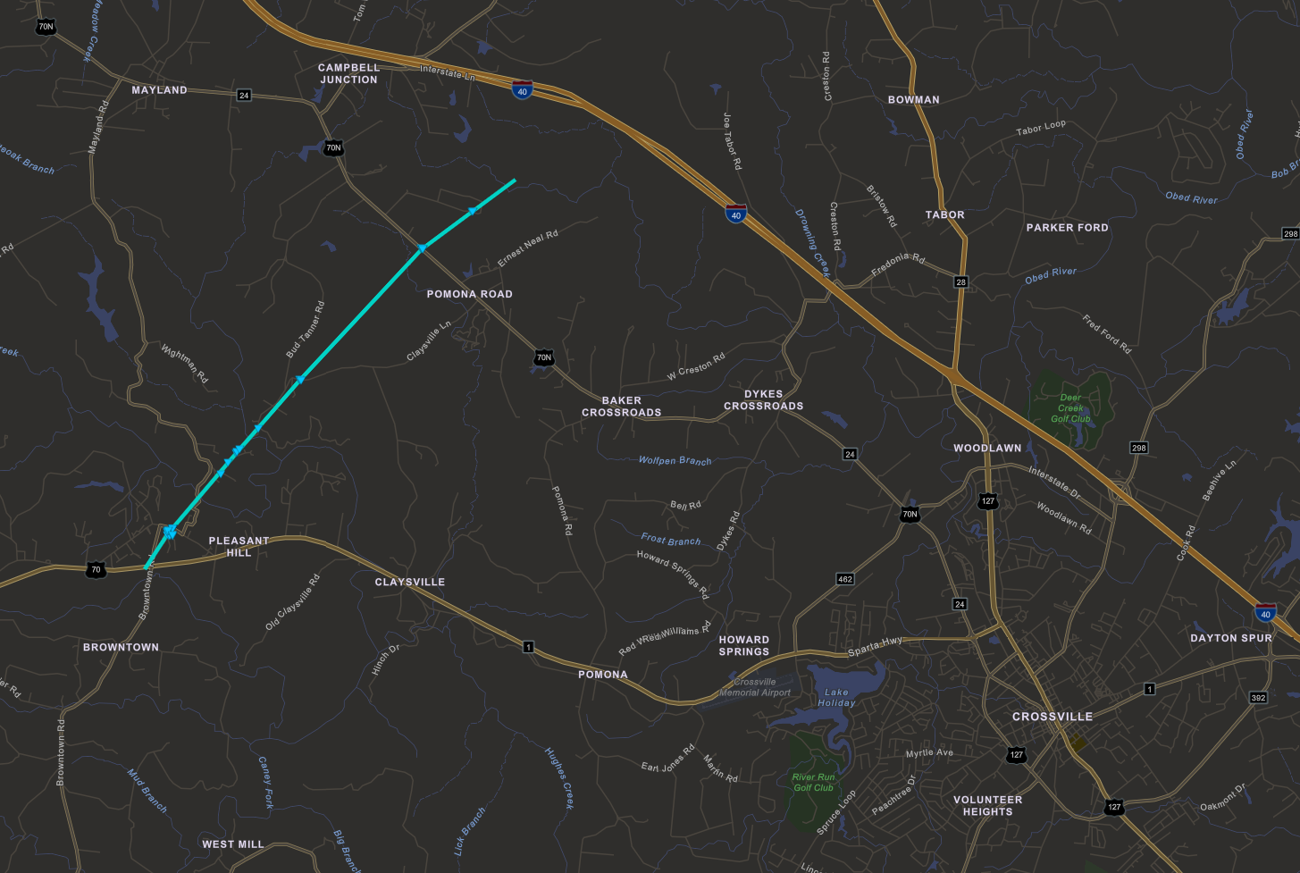
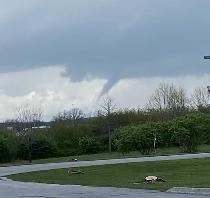
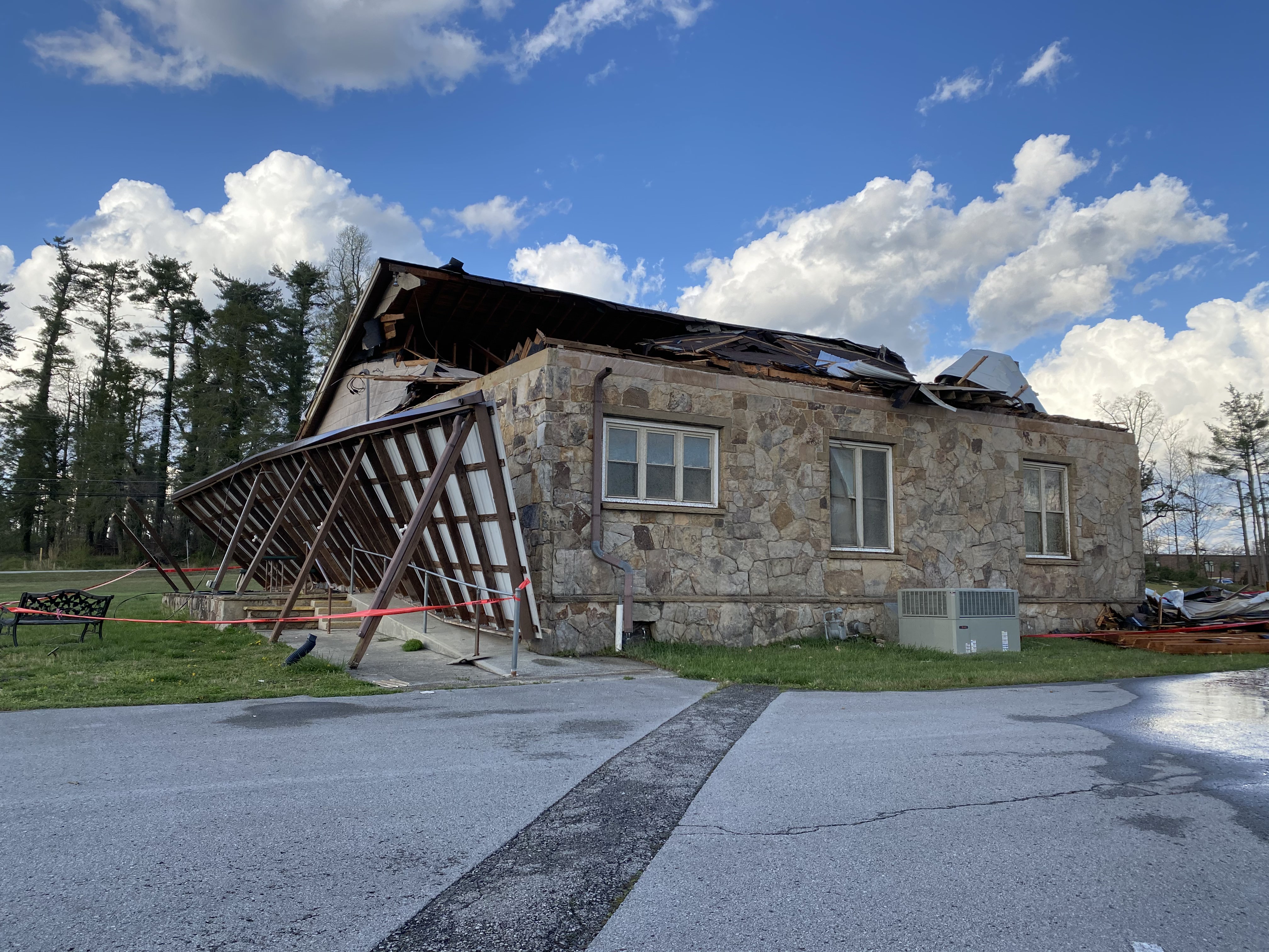
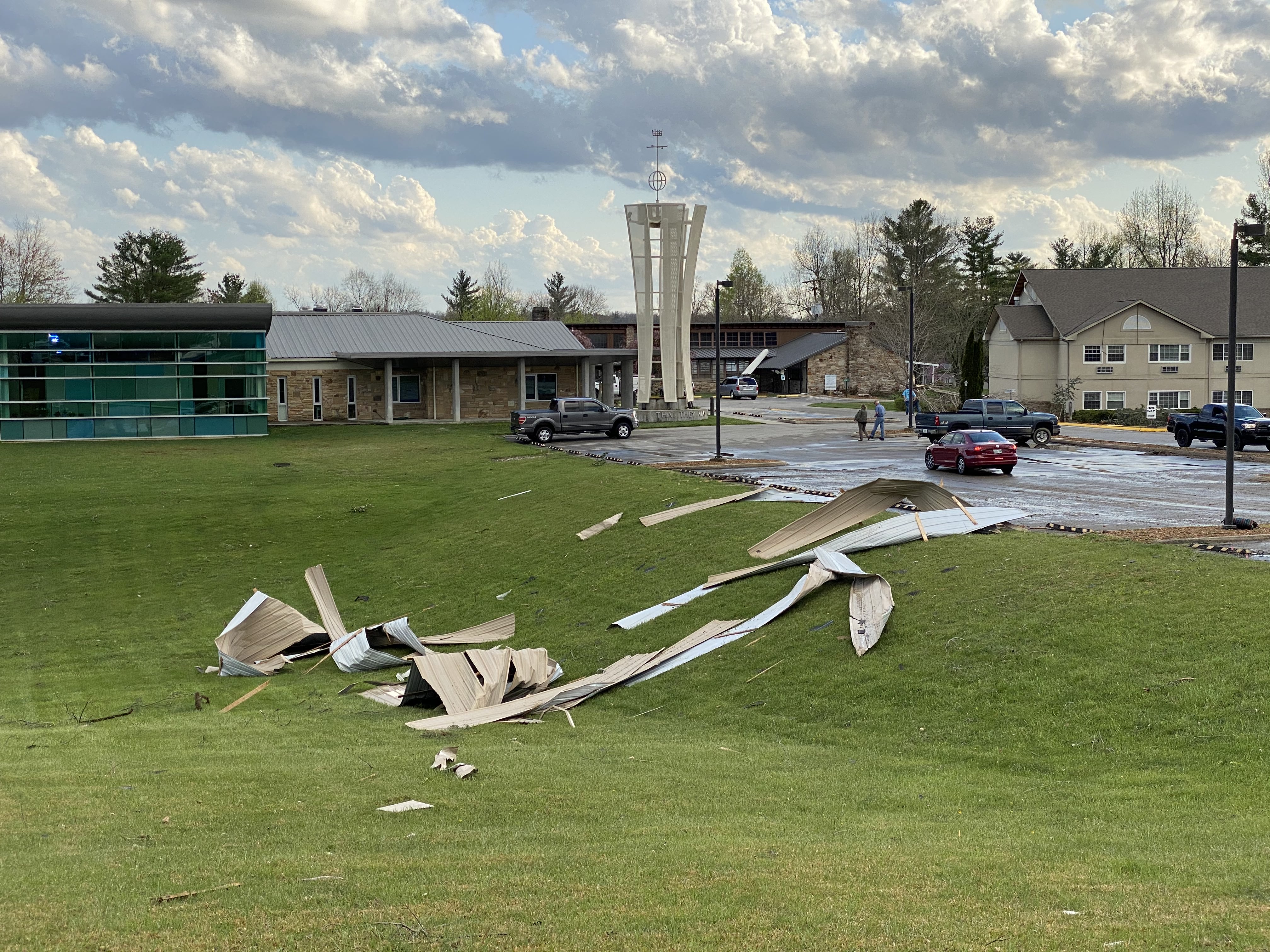
Scattered showers and thunderstorms developed across eastern parts of Middle Tennessee during the late morning and afternoon hours on April 8, 2021. With weak instability of up to 500 J/Kg of MLCAPE along with moderate low level shear around 200-250 m2/s2, several of these storms exhibited weak rotation at times. However, no reports were received until late afternoon when one small storm entered western Cumberland County. This small supercell thunderstorm dropped quarter-size hail on the Pleasant Hill community around 311 PM CDT. Shortly thereafter, numerous photos and videos showed a small EF-0 tornado touching down in the Pleasant Hill community, damaging several buildings. Many area residents witnessed the tornado as it tracked northeastward before lifting near Interstate 40, and the tornado was visible from over 10 miles away and could be seen from downtown Crossville. This storm and others went on to produce more tornadoes to the northeast in Morgan and Scott Counties. |
 April 8, 2021 SPC Storm Reports |
Tornadoes:
|
Tornado #1 - Pleasant Hill, TN
|
||||||||||||||||
The Enhanced Fujita (EF) Scale classifies tornadoes into the following categories:
| EF0 Weak 65-85 mph |
EF1 Moderate 86-110 mph |
EF2 Significant 111-135 mph |
EF3 Severe 136-165 mph |
EF4 Extreme 166-200 mph |
EF5 Catastrophic 200+ mph |
 |
|||||
Photos:
Cumberland County
 |
 |
 |
|
|
Tornado viewed from Crossville, TN (via Facebook) |
Damaged building in Pleasant Hill, TN (via @CumberlandWx) |
Damaged buildings in Pleasant Hill, TN (via @CumberlandWx) |
|
Storm Reports
PRELIMINARY LOCAL STORM REPORT...SUMMARY
NATIONAL WEATHER SERVICE NASHVILLE TN
918 AM CDT FRI APR 09 2021

..TIME...   ...EVENT...      ...CITY LOCATION...     ...LAT.LON...
..DATE...   ....MAG....      ..COUNTY LOCATION..ST.. ...SOURCE....
            ..REMARKS..

0311 PM     HAIL             PLEASANT HILL           35.98N  85.20W
04/08/2021  M1.00 INCH       CUMBERLAND         TN   PUBLIC

0315 PM     TORNADO          PLEASANT HILL           35.97N  85.20W
04/08/2021                   CUMBERLAND         TN   EMERGENCY MNGR

            THIS EF-0 TORNADO QUICKLY SPUN UP NEAR HWY 70 AND
            BROWNSTOWN RD THEN MOVED NE INTO PLEASANT HILL WHERE
            SEVERAL STRUCTURES SUFFERED ROOF AND SIDING DAMAGE ALONG
            WITH BROKEN GLASS INCLUDING THE ELEMENTARY SCHOOL AND A
            NURSING HOME. THE TORNADO MOVED ALONG BUD TANNER RD
            BLOWING DOWN TREES ALTHOUGH A COUPLE OF HOMES HAD MINOR
            ROOF AND SIDING DAMAGE. MINOR TREE DAMAGE CONTINUED ON
            CLAYSVILLE RD AND STONECREST LOOP BEFORE THE TORNADO
            LIFTED NEAR I-40. PATH LENGTH 5.8 MILES AND PATH WIDTH
            125 YARDS.


&&

EVENT NUMBER OHX2100438 OHX2100437


$$

SHAMBURGER
Damage Surveys
PUBLIC INFORMATION STATEMENT
NATIONAL WEATHER SERVICE NASHVILLE TN
907 AM CDT FRI APR 9 2021

...NWS DAMAGE SURVEY FOR 4/8/2021 TORNADO EVENT...

.PLEASANT HILL...

RATING:                 EF0
ESTIMATED PEAK WIND:    85 MPH
PATH LENGTH /STATUTE/:  5.8038 MILES
PATH WIDTH /MAXIMUM/:   125.0 YARDS
FATALITIES:             0
INJURIES:               TBD

START DATE:             04/08/2021
START TIME:             03:15 PM CDT
START LOCATION:         PLEASANT HILL / CUMBERLAND COUNTY / TN
START LAT/LON:          35.9708 / -85.2009

END DATE:               04/08/2021
END TIME:               03:25 PM CDT
END LOCATION:           5 NE PLEASANT HILL / CUMBERLAND COUNTY /
TN
END LAT/LON:            36.0314 / -85.1297

SURVEY SUMMARY:
THE EF-0 TORNADO QUICKLY SPUN UP NEAR HWY 70 AND BROWNSTOWN ROAD
CAUSING MINOR TREE DAMAGE. THE TORNADO THEN MOVED DIRECTLY INTO
THE PLEASANT HILL COMMUNITY WHERE SEVERAL STRUCTURES WERE DAMAGED
INCLUDING THE ELEMENTARY SCHOOL AND A NURSING HOME ALONG WITH A
FEW OTHER BUILDINGS. MOST OF THESE STRUCTURES SUSTAINED PORTIONS
OF THE ROOF LOST, GLASS BROKEN, AND/OR SIDING DAMAGE. AT THIS
POINT, THE TORNADO WAS THE STRONGEST AND WIDEST HERE. THE TORNADO
THEN TRAVELLED ALONG BUD TANNER ROAD CAUSING MOSTLY DOWNED TREES,
ALTHOUGH THERE WERE A COUPLE OF HOMES WITH MINOR ROOF AND SIDING
DAMAGE. MINOR TREE DAMAGE CONTINUED TO BE OBSERVED ON CLAYSVILLE
ROAD AND STONECREST LOOP WHERE THE TORNADO WEAKENED CONSIDERABLY
AND FINALLY DISSIPATED AFTER TRAVELING ALMOST 6 MILES.


&&

EF SCALE: THE ENHANCED FUJITA SCALE CLASSIFIES TORNADOES INTO THE
FOLLOWING CATEGORIES:

EF0...WEAK......65 TO 85 MPH
EF1...WEAK......86 TO 110 MPH
EF2...STRONG....111 TO 135 MPH
EF3...STRONG....136 TO 165 MPH
EF4...VIOLENT...166 TO 200 MPH
EF5...VIOLENT...>200 MPH

NOTE:
THE INFORMATION IN THIS STATEMENT IS PRELIMINARY AND SUBJECT TO
CHANGE PENDING FINAL REVIEW OF THE EVENT AND PUBLICATION IN NWS
STORM DATA.

$$

HURLEY/SHAMBURGER
 |
Media use of NWS Web News Stories is encouraged! Please acknowledge the NWS as the source of any news information accessed from this site. |
|