Overview
|
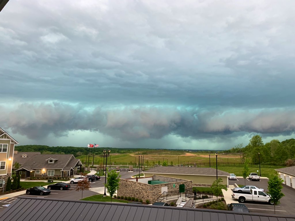
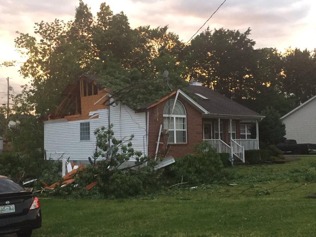
A complex of severe thunderstorms called a MCS (Mesoscale Convective System) developed across southern Kansas on Saturday night, May 2, 2020, then tracked eastward across southern Missouri and western Kentucky during the morning of May 3, 2020 before reaching Middle Tennessee in the afternoon. These storms produced widespread straight-line wind damage across nearly every county of Middle Tennessee, with numerous trees, power lines, and buildings damaged. Some of the worst damage occurred across the Nashville metro area, where winds between 60-80 mph knocked out power to over 130,000 customers - the worst power outage on record for the city. A peak wind gust of 71 mph was measured at the Nashville International Airport, which is the 5th highest on record at that location. Other areas with severe wind damage included Smith, Dickson, Lewis, Lawrence, Maury, Bedford, and Coffee Counties which also saw tens of thousands of customers lose power. Sadly, 1 man was killed and 3 other people were injured by falling trees due to the storms. Early indications are that this windstorm will be considered a "derecho", which is a unique form of MCS that causes major wind damage over hundreds of miles. This was also likely the worst straight-line wind event across Middle Tennessee since the July 13, 2004 derecho. |
|
Photos
 |
 |
 |
 |
| Charlotte Ave in West Nashville, TN (via #tSpotter on Twitter) |
14th Ave in Nashville, TN (via #tSpotter on Twitter) |
Cloverland Drive in Nashville, TN (via #tSpotter on Twitter) |
Hermitage, TN (via #tSpotter on Twitter) |
 |
 |
 |
 |
| Lavergne, TN (via #tSpotter on Twitter) |
Kittrell, TN (via Twitter) |
Dixon Springs, TN (via #tSpotter on Twitter) |
Tanglewood, TN (via #tSpotter on Twitter) |
 |
 |
 |
 |
| College Grove, TN (via #tSpotter on Twitter) |
Hohenwald, TN (via #tSpotter on Twitter) |
Franklin, TN (via #tSpotter on Twitter) |
Shelbyville, TN (via #tSpotter on Twitter) |
Radar
| OHX radar loop on May 3, 2020 |
Storm Reports
PRELIMINARY LOCAL STORM REPORT...SUMMARY
NATIONAL WEATHER SERVICE NASHVILLE TN
1034 PM CDT SUN MAY 03 2020

..TIME...   ...EVENT...      ...CITY LOCATION...     ...LAT.LON...
..DATE...   ....MAG....      ..COUNTY LOCATION..ST.. ...SOURCE....
            ..REMARKS..

0338 PM     TSTM WND DMG     8 WSW DOVER             36.46N  87.98W
05/03/2020                   STEWART            TN   EMERGENCY MNGR

            TREES DOWN ON HIGHWAY 232

0343 PM     TSTM WND GST     DOVER                   36.48N  87.84W
05/03/2020  E70 MPH          STEWART            TN   EMERGENCY MNGR

0345 PM     TSTM WND DMG     ERIN                    36.32N  87.70W
05/03/2020                   HOUSTON            TN   EMERGENCY MNGR

            NUMEROUS TREES DOWN AND POWER OUTAGES ACROSS HOUSTON
            COUNTY

0349 PM     TSTM WND DMG     MCEWEN                  36.11N  87.64W
05/03/2020                   HUMPHREYS          TN   SOCIAL MEDIA

            SEVERAL TREES DOWN AND OUTBUILDINGS DAMAGED AROUND
            MCEWEN

0351 PM     TSTM WND DMG     4 W DOVER               36.48N  87.91W
05/03/2020                   STEWART            TN   EMERGENCY MNGR

            TREE ON A HOUSE ON TWIN OAKS ROAD. NUMEROUS TREES DOWN
            ACROSS WESTERN STEWART COUNTY WITH APPX 1000 PEOPLE
            WITHOUT POWER

0400 PM     TSTM WND DMG     DICKSON                 36.08N  87.38W
05/03/2020                   DICKSON            TN   AMATEUR RADIO

            NUMEROUS TREES DOWN AND POWER OUTAGES THROUGHOUT
            DICKSON COUNTY INCLUDING ON HUMMINGBIRD LANE. TREE ON
            HOUSE AT WALNUT GROVE ROAD AT YELLOW CREEK ROAD

0405 PM     TSTM WND DMG     LINDEN                  35.61N  87.84W
05/03/2020                   PERRY              TN   SOCIAL MEDIA

            NUMEROUS REPORTS OF TREES AND POWER LINES DOWN WITH
            POWER OUTAGES ACROSS PERRY COUNTY

0408 PM     TSTM WND DMG     LYLES                   35.92N  87.35W
05/03/2020                   HICKMAN            TN   SOCIAL MEDIA

            SEVERAL TREES DOWN ON PINEWOOD ROAD...OAK SPRINGS
            ROAD...AND HIGHWAY 100

0410 PM     TSTM WND DMG     HOHENWALD               35.55N  87.56W
05/03/2020                   LEWIS              TN   SOCIAL MEDIA

            ROOFS BLOWN OFF SEVERAL BUILDINGS AND NUMEROUS TREES
            DOWN IN HOHENWALD

0415 PM     TSTM WND DMG     3 NE TENNESSEE CITY     36.12N  87.47W
05/03/2020                   DICKSON            TN   SOCIAL MEDIA

            TREES UPROOTED AND POWER LINES DOWN ON WALNUT GROVE
            ROAD

0415 PM     TSTM WND DMG     WAYNESBORO              35.32N  87.76W
05/03/2020                   WAYNE              TN   SOCIAL MEDIA

            TREES DOWN ACROSS WAYNESBORO INCLUDING AT THE GOLF
            COURSE

0418 PM     TSTM WND DMG     CLARKSVILLE             36.56N  87.35W
05/03/2020                   MONTGOMERY         TN   SOCIAL MEDIA

            SEVERAL TREES DOWN AROUND CLARKSVILLE

0419 PM     TSTM WND DMG     ASHLAND CITY            36.28N  87.06W
05/03/2020                   CHEATHAM           TN   SOCIAL MEDIA

            TREE LIMBS DOWN AND POWER OUTAGES

0427 PM     TSTM WND DMG     COLLINWOOD              35.18N  87.74W
05/03/2020                   WAYNE              TN   EMERGENCY MNGR

            NUMEROUS TREES DOWN ON THE NATCHEZ TRACE PARKWAY
            BLOCKING THE ROAD

0430 PM     TSTM WND DMG     COLUMBIA                35.62N  87.05W
05/03/2020                   MAURY              TN   AMATEUR RADIO

            TREES DOWN IN COLUMBIA...POWER OUT ACROSS MUCH OF THE
            COUNTY.

0430 PM     TSTM WND DMG     FRANKLIN                35.93N  86.84W
05/03/2020                   WILLIAMSON         TN   NWS EMPLOYEE

            TREES DOWN IN BACKYARD OF NWS EMPLOYEE HOUSE

0430 PM     TSTM WND DMG     SPRING HILL             35.74N  86.92W
05/03/2020                   MAURY              TN   SOCIAL MEDIA

            NUMEROUS TREES DOWN AND ROOF DAMAGE TO HOMES IN SPRING
            HILL

0435 PM     TSTM WND DMG     BRENTWOOD               36.00N  86.79W
05/03/2020                   WILLIAMSON         TN   TRAINED SPOTTER

            MULTIPLE LARGE TREES DOWN 1 MILE NORTH OF CONCORD RD
            AND WILSON PIKE INTERSECTION. 1 TREE FELL ON A DOG
            KENNEL...NO DOGS IN THE KENNEL AT THE TIME.

0435 PM     TSTM WND DMG     NASHVILLE               36.17N  86.78W
05/03/2020                   DAVIDSON           TN   UTILITY COMPANY

            NUMEROUS TREES AND POWER LINES DOWN ACROSS NASHVILLE.
            OVER 130000 CUSTOMERS WITHOUT POWER.

0435 PM     TSTM WND DMG     2 NW OAK HILL           36.09N  86.80W
05/03/2020                   DAVIDSON           TN   SOCIAL MEDIA

            HISTORIC 200 YEAR OLD OAK TREE BLOWN DOWN AT JT MOORE
            MIDDLE SCHOOL

0435 PM     TSTM WND DMG     4 ESE THOMPSON'S STATIO 35.79N  86.84W
05/03/2020                   WILLIAMSON         TN   BROADCAST MEDIA

            *** 1 FATAL *** TREE REPORTEDLY FELL ONTO AND KILLED A
            MAN NEAR BETHESDA ROAD AT HIGHWAY 431

0440 PM     TSTM WND DMG     3 NE NASHVILLE          36.20N  86.75W
05/03/2020                   DAVIDSON           TN   NWS EMPLOYEE

            TREE DOWN IN YARD OF HOME OF NWS EMPLOYEE

0441 PM     TSTM WND DMG     COLUMBIA                35.62N  87.05W
05/03/2020                   MAURY              TN   TRAINED SPOTTER

            LARGE TREE FELL ON A HOUSE ON MOCKINGBIRD LANE.

0442 PM     TSTM WND DMG     5 SE LAWRENCEBURG       35.19N  87.29W
05/03/2020                   LAWRENCE           TN   EMERGENCY MNGR

            BRICK GARAGE WALL COLLAPSED IN GUM SPRINGS, TN

0444 PM     TSTM WND GST     2 NW NASHBORO VILLAGE   36.12N  86.68W
05/03/2020  M71 MPH          DAVIDSON           TN   ASOS

            NASHVILLE AIRPORT ASOS MEASURED A WIND GUST OF 62 KNOTS
            / 71 MPH

0444 PM     TSTM WND DMG     5 SE DONELSON           36.11N  86.62W
05/03/2020                   DAVIDSON           TN   SOCIAL MEDIA

            FOUR CORNERS MARINA WAS DAMAGED AS WELL AS SEVERAL
            BOATS

0446 PM     TSTM WND DMG     2 SE CHERRY HILLS       36.05N  86.58W
05/03/2020                   DAVIDSON           TN   MEDIA

            *** 1 INJ *** FALLING TREE INJURED HIKER NEAR PERCY
            PRIEST LAKE

0447 PM     TSTM WND GST     NASHVILLE               36.17N  86.78W
05/03/2020  M62 MPH          DAVIDSON           TN   ASOS

0448 PM     TSTM WND DMG     1 N HERMITAGE HILLS     36.21N  86.63W
05/03/2020                   DAVIDSON           TN   SOCIAL MEDIA

            TREE ON HOUSE IN THE BONNAS NEIGHBORHOOD IN HERMITAGE

0450 PM     TSTM WND DMG     1 S MOUNT JULIET        36.19N  86.52W
05/03/2020                   WILSON             TN   NWS EMPLOYEE

            TREE DOWN ON HOME OF NWS EMPLOYEE. NUMEROUS TREES DOWN
            IN NEIGHBORHOOD

0450 PM     TSTM WND DMG     1 SW MOUNT JULIET       36.20N  86.53W
05/03/2020                   WILSON             TN   BROADCAST MEDIA

            TREE FELL ONTO HOME ON BROOKSTONE BLVD IN MOUNT JULIET
            CAUSING MAJOR DAMAGE

0451 PM     TSTM WND GST     2 NNE SMYRNA            36.01N  86.50W
05/03/2020  M61 MPH          RUTHERFORD         TN   ASOS

            SMYRNA AIRPORT ASOS MEASURED A WIND GUST OF 53 KNOTS /
            61 MPH

0451 PM     TSTM WND DMG     2 W GREEN HILL          36.23N  86.61W
05/03/2020                   DAVIDSON           TN   SOCIAL MEDIA

            TREE FELL ONTO A CAR ON SHUTE LANE NEAR BRANDYWINE

0454 PM     TSTM WND DMG     4 ENE MOUNT JULIET      36.23N  86.47W
05/03/2020                   WILSON             TN   EMERGENCY MNGR

            NUMEROUS TREES DOWN ACROSS MOUNT JULIET. BARN COLLAPSED
            AT 8485 LEBANON ROAD.

0455 PM     TSTM WND DMG     LA VERGNE               36.00N  86.57W
05/03/2020                   RUTHERFORD         TN   PUBLIC

            LARGE TREES DOWN...WIND GUST ESTIMATION OF 70 MPH

0458 PM     TSTM WND DMG     GALLATIN                36.38N  86.45W
05/03/2020                   SUMNER             TN   SOCIAL MEDIA

            NUMEROUS TREES DOWN IN GALLATIN

0500 PM     TSTM WND DMG     LAWRENCEBURG            35.25N  87.34W
05/03/2020                   LAWRENCE           TN   EMERGENCY MNGR

            WIDESPREAD WIND DAMAGE....TREES DOWN AND A BARN
            DAMAGED.

0502 PM     TSTM WND DMG     SHELBYVILLE             35.49N  86.45W
05/03/2020                   BEDFORD            TN   SOCIAL MEDIA

            ROOF BLOWN OFF TITLE MAX STORE ON MADISON STREET

0504 PM     TSTM WND GST     1 N LEBANON             36.22N  86.32W
05/03/2020  M70 MPH          WILSON             TN   TRAINED SPOTTER

            TREES DOWN.

0513 PM     TSTM WND DMG     9 W CARTHAGE            36.25N  86.10W
05/03/2020                   SMITH              TN   SOCIAL MEDIA

            NUMEROUS TREES DOWN AND BARN ROOFS BLOWN OFF IN THE
            FLAT ROCK ROAD AT HIGHWAY 70 AREA

0517 PM     TSTM WND DMG     WOODBURY                35.82N  86.07W
05/03/2020                   CANNON             TN   EMERGENCY MNGR

            *** 2 INJ *** NUMEROUS TREES DOWN WITH POWER OUTAGES
            ACROSS CANNON COUNTY. TREE FELL ONTO AN ATV INJURING 2
            PEOPLE.

0517 PM     TSTM WND DMG     TULLAHOMA               35.37N  86.22W
05/03/2020                   COFFEE             TN   SOCIAL MEDIA

            MULTIPLE TREES DOWN IN TULLAHOMA

0517 PM     TSTM WND DMG     4 WNW CARTHAGE          36.27N  86.02W
05/03/2020                   SMITH              TN   SOCIAL MEDIA

            NUMEROUS TREES DOWN ON LOCK 7 LANE

0518 PM     TSTM WND DMG     7 ESE HARTSVILLE        36.36N  86.05W
05/03/2020                   SMITH              TN   BROADCAST MEDIA

            SEVERAL TREES DOWN AND BUILDINGS DAMAGED IN DIXON
            SPRINGS

0520 PM     TSTM WND DMG     3 WNW CARTHAGE          36.28N  85.99W
05/03/2020                   SMITH              TN   SOCIAL MEDIA

            BARN DESTROYED IN THE HACKETT SUBDIVISION IN TANGLEWOOD

0525 PM     TSTM WND DMG     9 NNE CARTHAGE          36.39N  85.90W
05/03/2020                   SMITH              TN   SOCIAL MEDIA

            DESTROYED SHED ON DOG BRANCH ROAD

0535 PM     TSTM WND GST     4 WNW MCMINNVILLE       35.70N  85.84W
05/03/2020  M60 MPH          WARREN             TN   AWOS

            MCMINNVILLE AWOS MEASURED A WIND GUST OF 52 KNOTS / 60
            MPH

0540 PM     TSTM WND DMG     ALTAMONT                35.43N  85.73W
05/03/2020                   GRUNDY             TN   SOCIAL MEDIA

            TREES BLOWN DOWN IN FRONT OF THE COURTHOUSE

0545 PM     TSTM WND DMG     MONTEAGLE               35.24N  85.84W
05/03/2020                   GRUNDY             TN   SOCIAL MEDIA

            MULTIPLE TREES DOWN NEAR MONTEAGLE

0550 PM     TSTM WND DMG     COOKEVILLE              36.16N  85.51W
05/03/2020                   PUTNAM             TN   EMERGENCY MNGR

            MULTIPLE REPORTS OF TREES DOWN ACROSS PUTNAM COUNTY
            WITH POWER OUTAGES

0555 PM     TSTM WND DMG     LIVINGSTON              36.39N  85.33W
05/03/2020                   OVERTON            TN   EMERGENCY MNGR

            TREES DOWN BLOCKING GREENBRIAR ROAD AND HILHAM HIGHWAY
            AT STANDING STONE HIGHWAY. POWER LINES DOWN ON CARMACK
            STREET.

0615 PM     TSTM WND DMG     CROSSVILLE              35.95N  85.04W
05/03/2020                   CUMBERLAND         TN   EMERGENCY MNGR

            TREE ON A HOUSE ON VANDEVER ROAD NEAR HIGHWAY 127 S AND
            TREE ON A HOUSE ON OLD PEAVINE ROAD

0622 PM     TSTM WND GST     2 WNW CROSSVILLE        35.96N  85.08W
05/03/2020  M52 MPH          CUMBERLAND         TN   ASOS

            CROSSVILLE AIRPORT ASOS MEASURED A WIND GUST OF 45
            KNOTS / 52 MPH


&&

EVENT NUMBER OHX2000332 OHX2000333 OHX2000337 OHX2000375 OHX2000334
OHX2000338 OHX2000335 OHX2000379 OHX2000353 OHX2000336 OHX2000371
OHX2000372 OHX2000339 OHX2000373 OHX2000340 OHX2000354 OHX2000380
OHX2000341 OHX2000359 OHX2000374 OHX2000382 OHX2000361 OHX2000343
OHX2000370 OHX2000344 OHX2000383 OHX2000369 OHX2000342 OHX2000358
OHX2000357 OHX2000381 OHX2000345 OHX2000384 OHX2000355 OHX2000352
OHX2000385 OHX2000346 OHX2000362 OHX2000347 OHX2000386 OHX2000349
OHX2000356 OHX2000363 OHX2000376 OHX2000364 OHX2000365 OHX2000348
OHX2000377 OHX2000378 OHX2000350 OHX2000351 OHX2000366 OHX2000360


$$

SHAMBURGER
Peak Wind Gusts
PUBLIC INFORMATION STATEMENT
NATIONAL WEATHER SERVICE NASHVILLE TN
825 PM CDT SUN MAY 3 2020

...MAY 3, 2020 PEAK WIND GUSTS...

LOCATION                     SPEED     TIME/DATE       PROVIDER
NASHVILLE                    71 MPH    0444 PM 05/03   ASOS
CROSSVILLE                   61 MPH    0631 PM 05/03   CWOP
SMYRNA                       61 MPH    0456 PM 05/03   AWOS
MCMINNVILLE                  60 MPH    0535 PM 05/03   AWOS
CULLEOKA                     54 MPH    0445 PM 05/03   CWOP
3 SSW PULASKI                53 MPH    0455 PM 05/03   AWOS
CROSSVILLE AIRPORT           52 MPH    0622 PM 05/03   ASOS
WATERTOWN                    49 MPH    0522 PM 05/03   CWOP
COLUMBIA                     48 MPH    0435 PM 05/03   AWOS
LAWRENCEBURG                 47 MPH    0440 PM 05/03   CWOP
BRADYVILLE                   47 MPH    0525 PM 05/03   CWOP
TULLAHOMA                    46 MPH    0615 PM 05/03   AWOS
SPINGFIELD                   45 MPH    0455 PM 05/03   AWOS
MERIWETHER LEWIS             45 MPH    0422 PM 05/03   RAWS
WOODBURY                     44 MPH    0531 PM 05/03   CWOP
LIVINGSTON                   41 MPH    0615 PM 05/03   AWOS
CLARKSVILLE                  41 MPH    0423 PM 05/03   ASOS
LEBANON                      41 MPH    0515 PM 05/03   AWOS
SPRING HILL                  40 MPH    0500 PM 05/03   CWOP
BURNS                        39 MPH    0506 PM 05/03   RAWS
LEWISBURG TOWER              39 MPH    0606 PM 05/03   RAWS
SMYRNA                       38 MPH    0459 PM 05/03   CWOP
SHELBYVILLE                  38 MPH    0515 PM 05/03   CWOP
NASHVILLE                    37 MPH    0439 PM 05/03   CWOP
SHELBYVILLE                  37 MPH    0515 PM 05/03   AWOS
SHORT MOUNTAIN               36 MPH    0535 PM 05/03   CWOP
WATERTOWN                    36 MPH    0515 PM 05/03   CWOP
FORT CAMPBELL                36 MPH    0515 PM 05/03   RAWS
LAWRENCEBURG                 36 MPH    0435 PM 05/03   AWOS
STILLY HOLLOW                34 MPH    0426 PM 05/03   RAWS
WOODBURY                     33 MPH    0630 PM 05/03   CWOP
NASHVILLE                    32 MPH    0430 PM 05/03   CWOP
DICKSON                      31 MPH    0655 PM 05/03   AWOS
MURFREESBORO                 31 MPH    0635 PM 05/03   AWOS

OBSERVATIONS ARE COLLECTED FROM A VARIETY OF SOURCES WITH VARYING
EQUIPMENT AND EXPOSURES. WE THANK ALL VOLUNTEER WEATHER OBSERVERS
FOR THEIR DEDICATION. NOT ALL DATA LISTED ARE CONSIDERED OFFICIAL.

$$

SHAMBURGER
 |
Media use of NWS Web News Stories is encouraged! Please acknowledge the NWS as the source of any news information accessed from this site. |
|