Overview
|
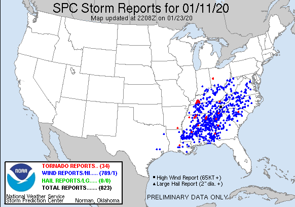
An unusually early in the year and very widespread severe weather outbreak affected much of the southeastern U.S. from January 10, 2020 into January 11, 2020. Numerous tornadoes and widespread damaging winds affected states from Texas eastward to South Carolina and as far north as Ohio. Across Middle Tennessee, a line of severe thunderstorms moved across the area during the morning and afternoon hours, producing no confirmed tornadoes but widespread damaging winds. Some of the worst damage striking Perry, Hickman, Dickson, and Clay Counties. Even prior to the storms moving across the area, strong south winds gusting over 50 mph in some areas caused sporadic wind damage and power outages in some locations. |
 SPC Storm Reports from January 11, 2020 |
Photos
 |
 |
 |
 |
| Trees and power lines down on Leatherwood Road south of Dover (Photo via Stewart County EMA) |
A destroyed barn was blown into Hudson Road in northwest Lawrence County (Photo via Lawrence County EMA) |
Flash flooding in Lawrence County (Photo via Lawrence County EMA) |
Tree down on Jones Avenue in east Nashville (Photo via Twitter) |
.jpg) |
.jpg) |
.jpg) |
.jpg) |
| Trees down on Baptist Ridge Road in southern Clay County (Photo via NWS storm survey) |
Damaged barn south of Celina in Clay County (Photo via NWS storm survey) |
Debris from a damaged farm in eastern Clay County (Photo via NWS storm survey) |
Roof damage to a church in northwest Overton County (Photo via NWS storm survey) |
Wind:
...PEAK WIND GUSTS ON JANUARY 11, 2020...
Location Speed
Mcminnville 53 MPH
Nashville Intl Airport 52 MPH
Clarksville Outlaw Field 47 MPH
Crossville Memorial Airport 47 MPH
Smyrna Airport 47 MPH
Tullahoma 45 MPH
Springfield 44 MPH
Shelbyville 41 MPH
Dickson 41 MPH
Nashville John C Tune Arpt 40 MPH
Columbia/Mount Pleasant 39 MPH
3 NNW Rockwood 39 MPH
Gallatin 38 MPH
Pulaski 38 MPH
Lawrenceburg 37 MPH
Lebanon 35 MPH
Sparta/Cookeville 33 MPH
Observations are collected from a variety of sources with varying
equipment and exposures. We thank all volunteer weather observers
for their dedication. Not all data listed are considered official.
$$
Shamburger
Radar
OHX Radar Loop from January 11, 2020
Public Information Statement
Public Information Statement
National Weather Service Nashville, TN
359 PM CST Sun Jan 12 2020

...NWS Damage Survey for 01/11/2020 Thunderstorm Wind Event...

.Straight-line Wind Damage in Clay County...

Peak wind                 E: 80-85 MPH
Path length /Statute/:    12 Miles
Path width /Maximum/:     500 Yards to 3 Miles
Fatalities:               0
Injuries:                 0

Start date:               01/11/2020
Start time:               1113 AM CST
Start location:           7 Miles South of Celina
Start Lat/Lon:            36.4450/-85.5190

End date:                 01/11/2020
End time:                 1130 AM CST
End location:             9 Miles Southwest of Wolf River Dock
End_lat/lon:              36.5433/-85.3353

Survey Summary:

NWS Nashville Damage Assessment Team investigated damage areas south
and east of Celina in Clay County today. The team found a roughly 12
mile path of sporadic straight-line wind damage mainly on the higher
elevations along this path.  Numerous trees were downed/snapped along
with a few barns and outbuildings experiencing roof and wall damage.
All damage assessed was laying towards the northeast/east-northeast
with zero convergence found.

Note:
The information in this statement is preliminary and subject to
change pending final review of the event and publication in NWS
Storm Data.

$$

Hurley/Whitehead
 |
Media use of NWS Web News Stories is encouraged! Please acknowledge the NWS as the source of any news information accessed from this site. |
 |