June 21, 2019 Derecho & Tornadoes
|
The most widespread damaging wind event to affect Middle Tennessee in at least 15 years struck the area during the evening hours on Friday, June 21, 2019. A long line of severe thunderstorms known as a MCS (mesoscale convective system) formed across southeast Missouri during the day, then moved southeast across Middle Tennessee between 6-10pm. With ample instability and unusually strong wind shear for late June in place, these storms produced widespread damaging winds in every Middle Tennessee County. Thousands of trees were blown down across the region, including some that had been standing since the Civil War. Damage to power lines and poles resulted in an estimated 100,000+ power outages, with some people without electricity for up to 1 week. In addition to the damaging winds, large hail up to quarter size was reported, and several mesocyclones within the line of storms spawned 4 tornadoes and several funnel clouds. Due to the long path and severity of the wind damage with this MCS, the Storm Prediction Center classified this event as a derecho. |
 |
Tornadoes:
|
Tornado #1 - Donelson, TN
Track Map 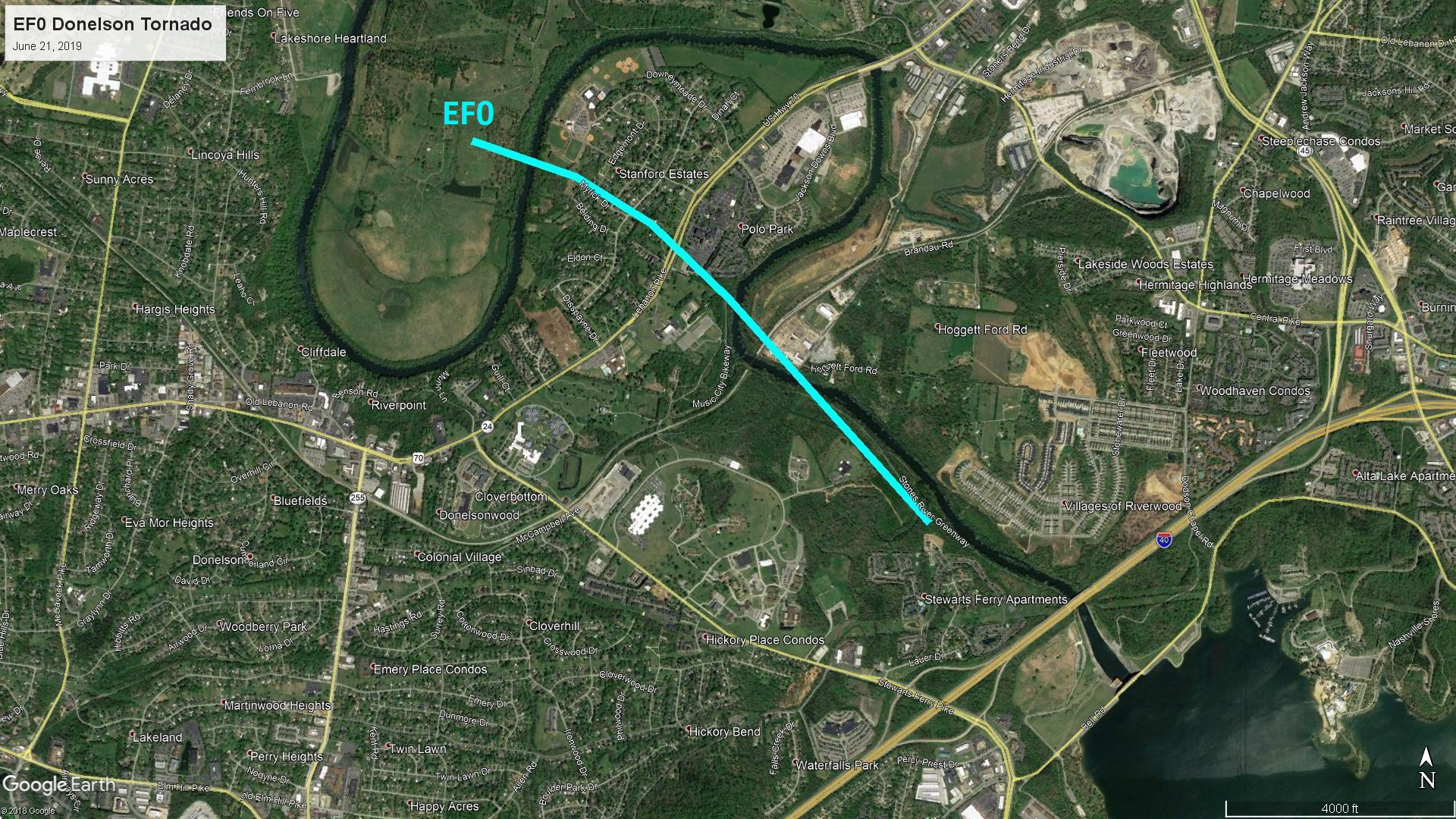 
|
||||||||||||||||
|
Tornado #2 - Antioch, TN
Track Map 
|
||||||||||||||||
|
Tornado #3 - Underwood, TN
Track Map 
|
||||||||||||||||
|
Tornado #4 - Armathwaite, TN
Track Map 
|
||||||||||||||||
The Enhanced Fujita (EF) Scale classifies tornadoes into the following categories:
| EF0 Weak 65-85 mph |
EF1 Moderate 86-110 mph |
EF2 Significant 111-135 mph |
EF3 Severe 136-165 mph |
EF4 Extreme 166-200 mph |
EF5 Catastrophic 200+ mph |
 |
|||||
Wind:
...MEASURED PEAK WIND GUSTS ON JUNE 21 2019...
Location Speed Time/Date Provider
Murfreesboro 56 MPH 0840 PM 06/21 AWOS
McMinnville 56 MPH 0920 PM 06/21 AWOS
Tullahoma 54 MPH 0920 PM 06/21 AWOS
Nashville Intl Airport 52 MPH 0759 PM 06/21 ASOS
Shelbyville 52 MPH 0855 PM 06/21 AWOS
Clarksville Outlaw Field 50 MPH 0654 PM 06/21 ASOS
Nashville John C Tune Arpt 50 MPH 0755 PM 06/21 AWOS
Crossville Memorial Airport 47 MPH 0934 PM 06/21 ASOS
Dickson 44 MPH 0735 PM 06/21 AWOS
Gallatin 43 MPH 0815 PM 06/21 AWOS
Livingston 41 MPH 0900 PM 06/21 AWOS
Observations are collected from a variety of sources with varying
equipment and exposures. We thank all volunteer weather observers
for their dedication. Not all data listed are considered official.
$$
Shamburger
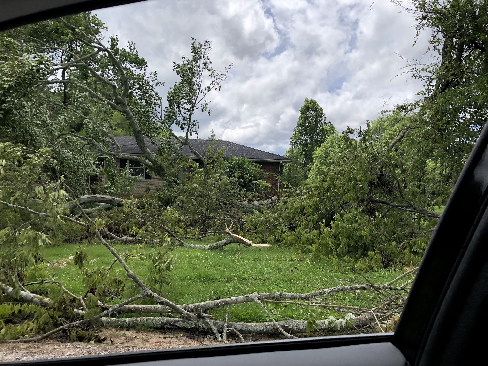
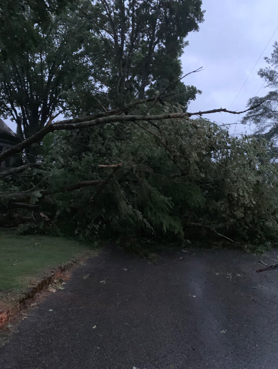
Photos:
Tornado Damage
 |
 |
 |
 |
| Davidson County near Donelson (NWS storm survey photo) |
Davidson County near Antioch (NWS storm survey photo) |
Macon County near Underwood (NWS storm survey photo) |
Fentress County near Armathwaite (NWS storm survey photo) |
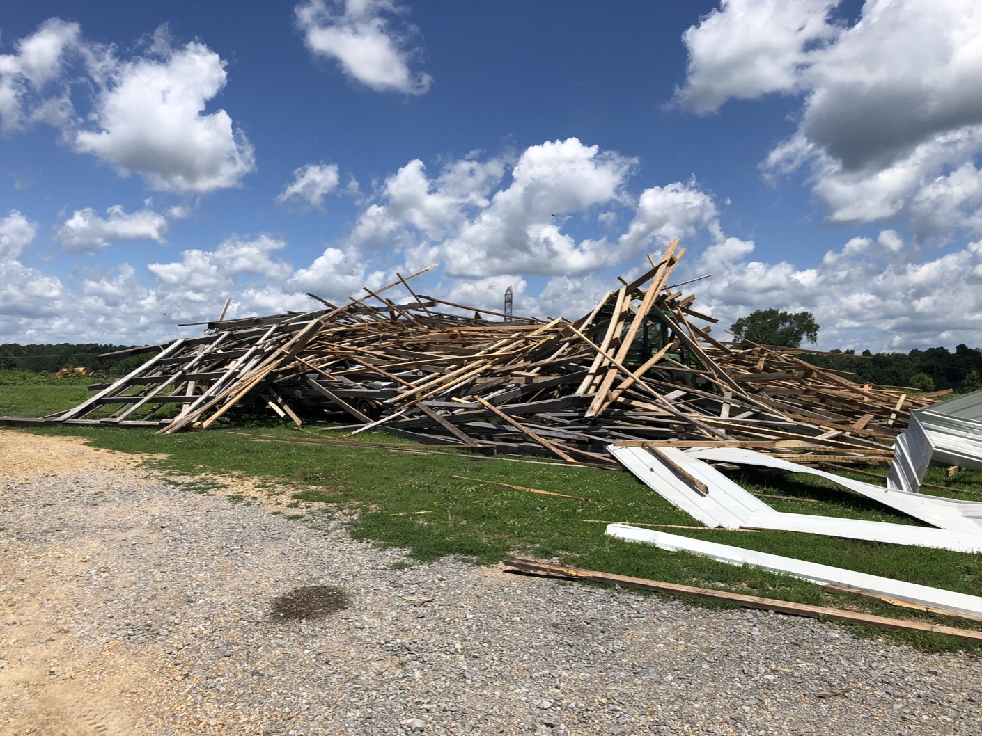
Downburst (Straight-line Wind) Damage
 |
 |
 |
 |
| Davidson County near Percy Priest Lake (via public) |
Macon County on Oak Knob Road (NWS storm survey photo) |
Overton County near Standing Stone Highway at Campground Road (via Tyler Allen, #tSpotter coordinator) |
Fentress County in Clarkrange (via James Bilbrey, Fentress County EMA) |
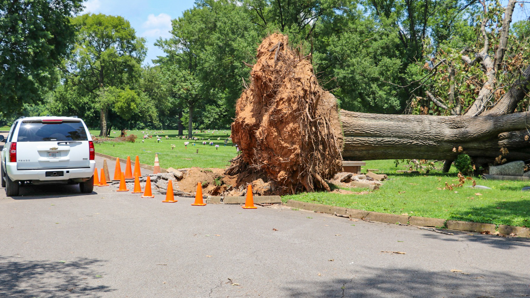 |
 |
 |
 |
| Davidson County in Mount Olivet Cemetery (via Wilson County EMA) |
Cheatham County near Kingston Springs (via Facebook) |
Perry County near Lobelville (via Facebook) |
Williamson County near Franklin (via Twitter) |
Radar:
 |
|||
| OHX Radar Loop from June 21, 2019 |
Storm Reports
PRELIMINARY LOCAL STORM REPORT...SUMMARY
NATIONAL WEATHER SERVICE NASHVILLE TN
1244 PM CDT MON JUL 01 2019
..TIME... ...EVENT... ...CITY LOCATION... ...LAT.LON...
..DATE... ....MAG.... ..COUNTY LOCATION..ST.. ...SOURCE....
..REMARKS..
0630 PM TSTM WND DMG 10 W DOVER 36.48N 88.02W
06/21/2019 STEWART TN EMERGENCY MNGR
TREES AND POWERLINES DOWN ON OLD PARIS LANDING ROAD AND
TOBACCO PORT ROAD.
0650 PM TSTM WND DMG DOVER 36.48N 87.84W
06/21/2019 STEWART TN EMERGENCY MNGR
TREES AND POWERLINES DOWN COUNTY WIDE.
0653 PM TSTM WND DMG TENNESSEE RIDGE 36.32N 87.76W
06/21/2019 HOUSTON TN 911 CALL CENTER
NUMEROUS TREES DOWN IN TENNESSEE RIDGE AND A FEW DOWN
IN ERIN.
0704 PM TSTM WND DMG CLARKSVILLE 36.56N 87.35W
06/21/2019 MONTGOMERY TN TRAINED SPOTTER
TREES DOWN ALONG WILMA-RUDOLPH BLVD.
0704 PM FUNNEL CLOUD 4 WNW LA VERGNE 36.01N 86.64W
06/21/2019 DAVIDSON TN BROADCAST MEDIA
VIDEO SHARED TO FOX 17 SHOWED FUNNEL CLOUD IN THIS
AREA. LOCATION ESTIMATED.
0709 PM TSTM WND DMG 1 E WAVERLY 36.09N 87.77W
06/21/2019 HUMPHREYS TN SOCIAL MEDIA
PHOTO OF TREE OVER ROAD IN WAVERLY.
0709 PM TSTM WND DMG 16 N DICKSON 36.31N 87.37W
06/21/2019 DICKSON TN PUBLIC
NUMEROUS TREES DOWN AROUND 6388 HIGHWAY 48 NORTH
0715 PM FUNNEL CLOUD 6 WSW SPRINGFIELD 36.47N 86.98W
06/21/2019 ROBERTSON TN PUBLIC
FUNNEL CLOUD FILMED FOR 5 MINUTES. NO APPARENT
TOUCHDOWN OR DAMAGE. LOCATION ESTIMATED.
0719 PM TSTM WND DMG CHARLOTTE 36.18N 87.35W
06/21/2019 DICKSON TN SOCIAL MEDIA
PHOTO OF TREE ACROSS BREEDEN RD. OFF HWY 49.
0727 PM TSTM WND DMG 8 N ASHLAND CITY 36.39N 87.06W
06/21/2019 CHEATHAM TN SOCIAL MEDIA
PHOTO OF POWER POLE LEANING OVER HWY 49 NEAR SWEETHOME
RD.
0729 PM TSTM WND DMG 1 SE DICKSON 36.07N 87.36W
06/21/2019 DICKSON TN SOCIAL MEDIA
POWER LINE SNAPPED ON OLD COLUMBIA RD. NEAR HWY 70
0736 PM TSTM WND DMG LOBELVILLE 35.75N 87.80W
06/21/2019 PERRY TN 911 CALL CENTER
WIDESPREAD TREE DAMAGE AND POWER OUTAGES. TREE FELL ON
A HOUSE IN LOBELVILLE.
0742 PM TSTM WND GST SPRINGFIELD 36.50N 86.88W
06/21/2019 E80 MPH ROBERTSON TN TRAINED SPOTTER
ESTIMATED 80 MPH WIND GUST IN SPRINGFIELD
0743 PM TSTM WND DMG FAIRVIEW 35.98N 87.12W
06/21/2019 WILLIAMSON TN AMATEUR RADIO
TREE DOWN ON HOUSE AT INTERSECTION OF FAIRLAWN RD AND
BRUSH CREEK RD.
0744 PM HAIL SPRINGFIELD 36.50N 86.88W
06/21/2019 E1.00 INCH ROBERTSON TN TRAINED SPOTTER
1 INCH HAIL IN SPRINGFIELD
0744 PM TSTM WND DMG CENTERVILLE 35.79N 87.45W
06/21/2019 HICKMAN TN LAW ENFORCEMENT
TREES DOWN COUNTY WIDE.
0750 PM TSTM WND DMG NASHVILLE 36.17N 86.78W
06/21/2019 DAVIDSON TN EMERGENCY MNGR
TREES AND POWER LINES DOWN THROUGHOUT THE COUNTY WITH
SEVERAL FALLING ON HOMES. 77 POWER POLES WERE SNAPPED.
OVER 48000 PEOPLE WITHOUT POWER.
0756 PM TSTM WND DMG HENDERSONVILLE 36.29N 86.60W
06/21/2019 SUMNER TN NWS EMPLOYEE
TREES DOWN IN HENDERSONVILLE.
0756 PM TSTM WND DMG 3 NNW DONELSON 36.20N 86.69W
06/21/2019 DAVIDSON TN NWS STORM SURVEY
A MICROBURST AFFECTED THE SUNSET VIEW AND CUMBERLAND
TRACE NEIGHBORHOODS ALONG MCGAVOCK PIKE AND ADJACENT
SIDE STREETS. SCATTERED TREES AND POWER LINES WERE BLOWN
DOWN IN THIS AREA TOWARDS THE SOUTHEAST. PATH LENGTH 2.5
MILES AND PATH WIDTH 0.3 MILES. MAX WINDS 65 MPH.
0757 PM TSTM WND DMG NASHVILLE 36.17N 86.78W
06/21/2019 DAVIDSON TN PUBLIC
TREES AND POWERLINES DOWN WESTERN HALF OF COUNTY.
0800 PM TSTM WND DMG 7 NNW LAFAYETTE 36.62N 86.08W
06/21/2019 MACON TN NWS STORM SURVEY
AN UNUSUALLY LARGE AND INTENSE DOWNBURST MOVED
SOUTHEAST ACROSS NORTHERN MACON COUNTY FROM THE KENTUCKY
BORDER TO AROUND HIGHWAY 261. SCATTERED TREES WERE
SNAPPED AND UPROOTED...NUMEROUS BARNS WERE DAMAGED OR
DESTROYED...A FEW HOMES WERE DAMAGED BY FALLING
TREES...AND SEVERAL POWER POLES AND LINES WERE BLOWN
DOWN. PATH LENGTH 8 MILES AND PATH WIDTH 1.5 MILES. MAX
WINDS 85 MPH.
0800 PM TORNADO 2 NNE DONELSON 36.18N 86.66W
06/21/2019 DAVIDSON TN NWS STORM SURVEY
A BRIEF EF0 TORNADO TOUCHED DOWN IN STONES RIVER BEND
PARK AND MOVED SOUTHEAST ACROSS THE STANDFORD ESTATES
SUBDIVISION AND STONES RIVER GREENWAY BEFORE LIFTING.
NUMEROUS LARGE TREES WERE SNAPPED AND UPROOTED ALONG THE
PATH WITH SOME FALLING ONTO AND HEAVILY DAMAGING HOMES.
PATH LENGTH 2 MILES AND PATH YARDS 200 YARDS. MAX WINDS
85 MPH.
0801 PM TSTM WND DMG 2 E HERMITAGE 36.19N 86.59W
06/21/2019 DAVIDSON TN NWS EMPLOYEE
TREE OVER ROAD WITH POWER LINES DOWN ON TULIP GROVE RD
JUST NORTH OF OLD LEBANON DIRT RD.
0801 PM TSTM WND DMG 2 WSW GREEN HILL 36.23N 86.60W
06/21/2019 DAVIDSON TN NWS EMPLOYEE
LARGE TREE OVER SAUNDERSVILLE RD. NEAR WYNTERGRACE FARM
RD. BLOCKING TRAFFIC.
0804 PM TORNADO 6 NNW LA VERGNE 36.08N 86.61W
06/21/2019 DAVIDSON TN NWS STORM SURVEY
A SMALL, BRIEF EF0 TORNADO TOUCHED DOWN IN ANTIOCH NEAR
THE INTERSECTION OF ANDERSON ROAD AND COUNTRY WAY ROAD
AND MOVED SOUTHEAST BEFORE LIFTING NEAR SMITH SPRINGS
PARKWAY AT MT VIEW ROAD. NUMEROUS TREES WERE SNAPPED AND
UPROOTED WITH A FEW FALLING ONTO HOMES. SEVERAL HOMES
HAD ROOF AND SIDING DAMAGE ON LEATHERBURY
COURT...SEASONS LAKE COURT...AND SEASONS DRIVE. PATH
LENGTH 1.25 MILES AND PATH WIDTH 50 YARDS. MAX WINDS 80
MPH.
0807 PM TORNADO 6 N LAFAYETTE 36.62N 86.02W
06/21/2019 MACON TN NWS STORM SURVEY
A BRIEF EF1 TORNADO TOUCHED DOWN IN FAR NORTHERN MACON
COUNTY NEAR GREEN VALLEY ROAD AND MOVED EASTWARD ACROSS
OAK KNOB ROAD AND UNDERWOOD ROAD BEFORE LIFTING.
HUNDREDS OF TREES WERE SNAPPED AND UPROOTED AND SEVERAL
BARNS AND OUTBUILDINGS WERE DAMAGED. PATH LENGTH 1.7
MILES AND PATH WIDTH 150 YARDS. MAX WINDS 90 MPH.
0808 PM TSTM WND DMG FRANKLIN 35.93N 86.84W
06/21/2019 WILLIAMSON TN LAW ENFORCEMENT
TREES DOWN ACROSS THE COUNTY. CITIES OF FRANKLIN AND
FAIRVIEW WERE THE HARDEST HIT AREAS.
0814 PM TSTM WND DMG NASHVILLE 36.17N 86.78W
06/21/2019 DAVIDSON TN TRAINED SPOTTER
TREES DOWN ACROSS EASTERN PORTIONS OF THE COUNTY
0815 PM TSTM WND DMG HOHENWALD 35.55N 87.56W
06/21/2019 LEWIS TN 911 CALL CENTER
TREES DOWN AND POWER OUT, ESPECIALLY ON HWY 20.
0815 PM FUNNEL CLOUD 5 SSE RURAL HILL 36.05N 86.48W
06/21/2019 RUTHERFORD TN SOCIAL MEDIA
FACEBOOK VIDEO SHOWED FUNNEL CLOUD IN THIS AREA.
LOCATION ESTIMATED.
0817 PM TSTM WND DMG LAFAYETTE 36.52N 86.03W
06/21/2019 MACON TN LAW ENFORCEMENT
TREES DOWN COUNTY WIDE. DAMAGE TO BARNS AND HOUSES
ACROSS THE COUNTY. *POSSIBLE* TORNADO ACROSS NORTHERN
PORTION OF COUNTY.
0820 PM TSTM WND DMG 8 N WAYNESBORO 35.44N 87.76W
06/21/2019 WAYNE TN 911 CALL CENTER
TREES AND POWER LINES DOWN ACROSS THE NORTH-CENTRAL
PORTION OF WAYNE COUNTY.
0820 PM TSTM WND DMG COLUMBIA 35.62N 87.05W
06/21/2019 MAURY TN EMERGENCY MNGR
TREES DOWN AND POWER OUTAGES COUNTY WIDE. FIRE AND
SHERIFF DEPT. ASSISTING IN REMOVING TREES FROM MAIN
ROADWAYS.
0822 PM TSTM WND DMG WALTERHILL 35.96N 86.38W
06/21/2019 RUTHERFORD TN NWS EMPLOYEE
WIDESPREAD TREE DAMAGE IN WALTERHILL.
0822 PM TSTM WND DMG HARTSVILLE 36.39N 86.16W
06/21/2019 TROUSDALE TN LAW ENFORCEMENT
TREES AND POWER LINES DOWN COUNTY WIDE...MOST NUMEROUS
ACROSS WESTERN HALF OF COUNTY.
0824 PM TSTM WND DMG 3 SW EAGLEVILLE 35.71N 86.70W
06/21/2019 MARSHALL TN SOCIAL MEDIA
PHOTO OF TREE OVER FULLER RD IN COLLEGE GROVE.
0824 PM TSTM WND DMG WALTERHILL 35.96N 86.38W
06/21/2019 RUTHERFORD TN NWS STORM SURVEY
A LARGE AND INTENSE DOWNBURST AFFECTED NORTHERN
RUTHERFORD COUNTY FROM I-840 SOUTHEASTWARD TO AROUND THE
WALTERHILL AREA. DOZENS OF TREES WERE SNAPPED AND
UPROOTED...POWER LINES AND POLES WERE BLOWN DOWN...AND
FENCES AND OUTBUILDINGS DAMAGED. MAX WINDS 85 MPH.
0828 PM TSTM WND DMG 2 WNW MURFREESBORO 35.86N 86.42W
06/21/2019 RUTHERFORD TN SOCIAL MEDIA
LARGE TREES DOWN OFF MEDICAL CENTER PKWY.
0829 PM TSTM WND DMG 2 E INGLEWOOD 36.21N 86.69W
06/21/2019 DAVIDSON TN PUBLIC
TREES DOWN AT OPRY MILLS
0836 PM TSTM WND DMG READYVILLE 35.83N 86.17W
06/21/2019 CANNON TN FIRE DEPT/RESCUE
TREES DOWN ON BRADYVILLE RD AND LOCKE'S CREEK NEAR
READYVILLE.
0841 PM TSTM WND DMG LAWRENCEBURG 35.25N 87.34W
06/21/2019 LAWRENCE TN LAW ENFORCEMENT
TREES DOWN ACROSS LAWRENCEBURG
0842 PM TSTM WND DMG GAINESBORO 36.36N 85.65W
06/21/2019 JACKSON TN 911 CALL CENTER
WIDESPREAD TREE DAMAGE AND POWER OUTAGES ACROSS JACKSON
COUNTY.
0844 PM TSTM WND DMG SHELBYVILLE 35.49N 86.45W
06/21/2019 BEDFORD TN PUBLIC
NUMEROUS TREES DOWN COUNTY WIDE.
0844 PM TSTM WND DMG MURFREESBORO 35.85N 86.39W
06/21/2019 RUTHERFORD TN PUBLIC
NUMEROUS TREES DOWN COUNTY WIDE.
0844 PM TSTM WND DMG CELINA 36.55N 85.50W
06/21/2019 CLAY TN LAW ENFORCEMENT
TREES AND POWERLINES DOWN COUNTY WIDE. A DOWNED
POWERLINE CAUSED A FIRE WHICH BURNED AN OUTDOOR GARAGE
DOWN TO THE GROUND AT NEELY CREEK.
0845 PM TSTM WND DMG SUMMERTOWN 35.43N 87.31W
06/21/2019 LAWRENCE TN EMERGENCY MNGR
2 36 INCH TREES BLOWN DOWN ON A HOUSE TRAILER. POWER
LINES DOWN THROUGHOUT THE COUNTY.
0845 PM TSTM WND DMG 8 W LIVINGSTON 36.39N 85.47W
06/21/2019 OVERTON TN TRAINED SPOTTER
NUMEROUS TREES DOWN IN AN AT LEAST 2 MILE LONG BY 0.75
MILE WIDE PATH FROM OLD UNION ROAD AT BOLES ROAD TO
STANDING STONE HIGHWAY AT CAMPGROUND ROAD.
0850 PM TSTM WND DMG 8 N LIVINGSTON 36.51N 85.30W
06/21/2019 OVERTON TN NWS EMPLOYEE
TIN PEELED OFF BARN ON OZONE ROAD. A FEW TREES DOWN IN
THE AREA.
0852 PM TSTM WND DMG COOKEVILLE 36.16N 85.51W
06/21/2019 PUTNAM TN PUBLIC
TREES AND POWERLINES DOWN COUNTY WIDE.
0854 PM TSTM WND DMG SMITHVILLE 35.96N 85.82W
06/21/2019 DE KALB TN LAW ENFORCEMENT
TREES AND POWERLINES DOWN COUNTY WIDE.
0902 PM TSTM WND DMG LIVINGSTON 36.39N 85.33W
06/21/2019 OVERTON TN PUBLIC
POWER LINES DOWN ALONG PEACH DR AND HIDDEN VALLEY LANE.
TREE DOWN ALONG CELINA HWY AND STANDING STONE HWY. POWER
LINES DOWN ALONG FLETCHER DR.
0902 PM TSTM WND DMG COOKEVILLE 36.16N 85.51W
06/21/2019 PUTNAM TN MEDIA
TREE DOWN ON HOUSE ALONG GAINESBORO-GRADE.
0902 PM TSTM WND DMG LIVINGSTON 36.39N 85.33W
06/21/2019 OVERTON TN PUBLIC
TREES AND POWERLINES DOWN COUNTY WIDE.
0904 PM TSTM WND DMG BYRDSTOWN 36.57N 85.13W
06/21/2019 PICKETT TN LAW ENFORCEMENT
TREES AND POWER LINES DOWN COUNTY WIDE.
0906 PM TSTM WND DMG CAIRO BEND 36.24N 86.40W
06/21/2019 WILSON TN NWS EMPLOYEE
TREES DOWN
0909 PM TSTM WND DMG TULLAHOMA 35.37N 86.22W
06/21/2019 COFFEE TN EMERGENCY MNGR
TREES DOWN IN TULLAHOMA AND ACROSS NORTHERN COFFEE
COUNTY.
0911 PM TSTM WND DMG 4 WSW MCMINNVILLE 35.66N 85.84W
06/21/2019 WARREN TN PUBLIC
PUBLIC REPORTED 18 TREES BLOWN DOWN AROUND THEIR HOME
AT 499 PEACH AVE NEAR MCMINNVILLE.
0920 PM TSTM WND DMG JAMESTOWN 36.43N 84.94W
06/21/2019 FENTRESS TN AMATEUR RADIO
COUNTY WIDE TREE DAMAGE AND POWER OUTAGES.
0920 PM TSTM WND DMG 13 ENE MONTEREY 36.19N 85.02W
06/21/2019 FENTRESS TN NWS STORM SURVEY
A MICROBURST CAUSED SUBSTANTIAL WIND DAMAGE IN AND
AROUND CLARKRANGE. THE FRONT PORCH OF A FUNERAL HOME WAS
BLOWN DOWN...ANOTHER FUNERAL HOME SUFFERED ROOF
DAMAGE...SHEET METAL ROOFING WAS BLOWN OFF A CAR WASH
AND A STORAGE BUILDING...AND SEVERAL SCATTERED TREES
WERE SNAPPED AND UPROOTED. PATH LENGTH 1.5 MILES AND
PATH WIDTH 0.5 MILES. MAX WINDS 70 MPH.
0922 PM TSTM WND DMG MCMINNVILLE 35.69N 85.78W
06/21/2019 WARREN TN LAW ENFORCEMENT
TREES DOWN COUNTY WIDE.
0924 PM TORNADO 8 ESE JAMESTOWN 36.38N 84.80W
06/21/2019 FENTRESS TN NWS STORM SURVEY
AN EF1 TORNADO TOUCHED DOWN IN THE ARMATHWAITE
COMMUNITY WEST OF BRANNON LANE AND MOVED EAST ACROSS
STOCKTON ROAD...MT HELEN ROAD...HM BROOKS
ROAD...CHESTNUT RIDGE ROAD...AND SAM SMITH ROAD BEFORE
LIFTING. HUNDREDS OF TREES WERE SNAPPED AND UPROOTED AND
A FEW BARNS AND OUTBUILDINGS WERE DAMAGED. PATH LENGTH 3
MILES AND PATH WIDTH 150 YARDS. MAX WINDS 90 MPH.
0928 PM TSTM WND DMG CROSSVILLE 35.95N 85.04W
06/21/2019 CUMBERLAND TN EMERGENCY MNGR
TREE DOWN OVER HWY 70 N AND POWER OUTAGES IN CUMBERLAND
COUNTY.
0930 PM TSTM WND DMG SPARTA 35.93N 85.47W
06/21/2019 WHITE TN LAW ENFORCEMENT
TREES DOWN COUNTY WIDE.
0937 PM TSTM WND DMG TRACY CITY 35.26N 85.75W
06/21/2019 GRUNDY TN LAW ENFORCEMENT
TREES DOWN IN TRACY CITY AND MONTEAGLE.
0943 PM TSTM WND DMG SPENCER 35.74N 85.46W
06/21/2019 VAN BUREN TN LAW ENFORCEMENT
TREES DOWN COUNTY WIDE.
&&
EVENT NUMBER OHX1900385 OHX1900336 OHX1900368 OHX1900337 OHX1900445
OHX1900366 OHX1900441 OHX1900446 OHX1900377 OHX1900374 OHX1900379
OHX1900367 OHX1900338 OHX1900341 OHX1900339 OHX1900345 OHX1900442
OHX1900365 OHX1900433 OHX1900342 OHX1900434 OHX1900435 OHX1900353
OHX1900354 OHX1900436 OHX1900437 OHX1900347 OHX1900343 OHX1900372
OHX1900447 OHX1900370 OHX1900369 OHX1900380 OHX1900357 OHX1900373
OHX1900362 OHX1900438 OHX1900360 OHX1900344 OHX1900363 OHX1900346
OHX1900364 OHX1900348 OHX1900349 OHX1900375 OHX1900371 OHX1900443
OHX1900448 OHX1900352 OHX1900378 OHX1900350 OHX1900351 OHX1900355
OHX1900376 OHX1900356 OHX1900358 OHX1900444 OHX1900361 OHX1900439
OHX1900382 OHX1900440 OHX1900359 OHX1900381 OHX1900384 OHX1900383
JUNE 21, 2019 STORM REPORTS SUMMARY
$$
SHAMBURGER
Damage Surveys
Public Information Statement
National Weather Service Nashville TN
313 PM CDT Fri Jun 28 2019

...SUMMARY OF JUNE 21 2019 TORNADO AND DAMAGING WIND SURVEYS...

Storm surveys from the Friday, June 21, 2019 severe storms have
found a total of 4 tornadoes and widespread, very damaging
straight-line winds across Middle Tennessee.

.Antioch EF0 Tornado...

Rating:                 EF0
Estimated Peak Wind:    80 mph
Path Length /statute/:  1.25 miles
Path Width /maximum/:   50.0 yards
Fatalities:             0
Injuries:               0

Start Date:             06/21/2019
Start Time:             08:04 PM CDT
Start Location:         5 NNW La Vergne / Davidson County / TN
Start Lat/Lon:          36.0783 / -86.6076

End Date:               06/21/2019
End Time:               08:06 PM CDT
End Location:           5 SW Rural Hill / Davidson County / TN
End Lat/Lon:            36.0725 / -86.5892

Survey Summary:
A small, brief EF0 tornado touched down in Antioch near the
intersection of Anderson Road and Country Way Road. The tornado
took a U-shaped path and moved southeast across Oak Trees Court,
Country Meadow Drive, Country Meadow Court, Country Lawn Drive,
Towne Village Road, Fall Court, Dove Creek Road, and Huntingboro
Trail, snapping and uprooting numerous trees in a narrow,
convergent path. A few trees fell onto homes causing minor damage.
Turning more eastward, the tornado strengthened and caused
significant roof and siding damage to many homes along Leatherbury
Court, Seasons Lake Court, and Seasons Drive. The tornado appears
to have lifted north of the intersection of Smith Springs Parkway
and Mt View Road.


.Donelson EF0 Tornado...

Rating:                 EF0
Estimated Peak Wind:    85 mph
Path Length /statute/:  2.0 miles
Path Width /maximum/:   200.0 yards
Fatalities:             0
Injuries:               0

Start Date:             06/21/2019
Start Time:             08:00 PM CDT
Start Location:         6 SW Green Hill / Davidson County / TN
Start Lat/Lon:          36.1824 / -86.6572

End Date:               06/21/2019
End Time:               08:02 PM CDT
End Location:           6 SSW Green Hill / Davidson County / TN
End Lat/Lon:            36.1644 / -86.63

Survey Summary:
A brief EF0 tornado touched down in the Stones River Bend Park and
moved southeast, snapping several trees along the river. Moving
through the Standford Estates subdivision, the tornado blew down
numerous large trees in a convergent pattern on Edgemont Drive,
Myrick Drive, Stanford Drive, Belding Drive, and Jenry Drive, with
some trees falling onto and heavily damaging homes. Many of these
same homes were also damaged in a severe microburst on April 18,
2017. The tornado continued southeast and blew down many more
trees on Wellington Square, Lebanon Pike, and along the Stones
River Greenway before lifting. Special thanks to Nashville Office
of Emergency Management for their assistance with this survey.


.Two Rivers Damaging Wind Event...

Peak wind /Estimated/:    65 mph
Path Length /statute/:    2.5 miles
Path Width /maximum/:     0.3 miles
Fatalities:               0
Injuries:                 0

Date:                     06/21/2019
Time:                     07:56 PM CDT to 07:58 PM CDT
Location:                 3 NNW Donelson to 0.7 N Donelson

To the west of the EF0 Donelson tornado, a path of damaging
straight-line winds affected areas generally along McGavock Pike
and adjacent side streets from near Opry Mills Mall southeastward
to the Stones River bend north of Lebanon Pike. Scattered trees
were snapped and uprooted in a southeast direction and several
power lines were blown down in this area.


.North Macon County EF1 Tornado...

Rating:                 EF1
Estimated Peak Wind:    90 mph
Path Length /statute/:  1.7 miles
Path Width /maximum/:   150.0 yards
Fatalities:             0
Injuries:               0

Start Date:             06/21/2019
Start Time:             08:07 PM CDT
Start Location:         4 ESE Amos / Macon County / KY
Start Lat/Lon:          36.617 / -86.0216

End Date:               06/21/2019
End Time:               08:09 PM CDT
End Location:           4 SW Akersville / Macon County / KY
End Lat/Lon:            36.6157 / -85.9917

Survey Summary:
A short but intense EF-1 tornado touched down in far northern
Macon County near Green Valley Road and moved eastward across Oak
Knob Road and along Underwood Road before lifting. Hundreds of
trees were snapped and uprooted along the path, a few homes were
damaged by falling trees, and several barns and outbuildings were
damaged. The tornado damage was surrounded by a massive 8 mile
long by 1.5 mile wide downburst which caused more scattered but
severe wind damage over a much wider area.


.North Macon County Damaging Wind Event...

Peak wind /Estimated/:    85 mph
Path Length /statute/:    8 miles
Path Width /maximum/:     1.5 miles
Fatalities:               0
Injuries:                 0

Date:                     06/21/2019
Time:                     08:00 PM CDT to 08:11 PM CDT
Location:                 8 NNW Lafayette to 7 NE Lafayette

An unusually large and intense downburst moved southeast out of
Kentucky across northern Macon County, causing severe straight-
line wind damage from Highway 10 at the Kentucky border
southeastward to Highway 261, including the Green Valley, White
Oak, Underwood, and Galen communities. Along nearly every road in
this large area, scattered trees were snapped and uprooted,
numerous barns were damaged or destroyed, a few homes were
damaged by falling trees, and several power lines and poles were
downed.


.East Fentress County EF1 Tornado...

Rating:                 EF1
Estimated Peak Wind:    90 mph
Path Length /statute/:  3.0 miles
Path Width /maximum/:   150.0 yards
Fatalities:             0
Injuries:               0

Start Date:             06/21/2019
Start Time:             09:24 PM CDT
Start Location:         4 E Allardt / Fentress County / TN
Start Lat/Lon:          36.3802 / -84.7994

End Date:               06/21/2019
End Time:               09:27 PM CDT
End Location:           3 WNW Rugby / Fentress County / TN
End Lat/Lon:            36.3816 / -84.7461

Survey Summary:
An EF-1 tornado touched down in the Stockton community west of
Brannon Lane and moved east across Stockton Road, Mt Helen Road,
HM Brooks Road, Chestnut Ridge Road, and Sam Smith Road before
lifting. A few barns and outbuildings were damaged and hundreds of
large trees were snapped and uprooted along the path. The worst
damage was along Sam Smith Road where a strongly convergent,
intense damage swath was cut through the forest and a home
narrowly missed being crushed by numerous trees. The tornado path
may have been longer to the east but that area is not accessible
by roads. Special thanks to Fentress County Emergency Management
for assisting us with this survey.


.Southern Fentress County Damaging Wind Event...

Peak wind /Estimated/:    70 MPH
Fatalities:               0
Injuries:                 0

Date:                     06/21/2019
Time:                     09:20 PM CDT
Location:                 Clarkrange

A NWS and Fentress County Emergency Management storm survey
determined that straight-line winds up to 70 mph struck the
Clarkrange area. The front porch of a funeral home was blown down,
a car wash lost much of its sheet metal roofing, and a gas station
had damage to its gas pump awning. A few other buildings had minor
exterior damage, and several scattered trees were snapped and
uprooted.


EF Scale: The Enhanced Fujita Scale classifies tornadoes into the
following categories:

EF0...Weak......65 to 85 mph
EF1...Weak......86 to 110 mph
EF2...Strong....111 to 135 mph
EF3...Strong....136 to 165 mph
EF4...Violent...166 to 200 mph
EF5...Violent...>200 mph

Note:
The information in this statement is preliminary and subject to
change pending final review of the events and publication in NWS
Storm Data.

$$

Shamburger/MacDonald
 |
Media use of NWS Web News Stories is encouraged! Please acknowledge the NWS as the source of any news information accessed from this site. |
|

