| March 18, 2013 Tornadoes & Severe Weather |
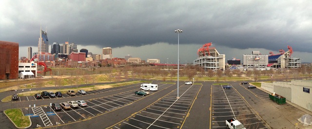
 A shelf cloud overhangs LP Field in Nashville as strong-to-severe thunderstorms moved across the area on the morning of March 18, 2013. Shelf clouds form as warm, moist air rises along the front edge of a gust front and are associated with strong to severe thunderstorms. This photo was taken along the Shelby Street pedestrian bridge, looking northwest at 845 am CDT on March 18, 2013. [PHOTO CREDIT: Chayot Thongklin, Chief Meteorologist for Rural TV] |

| Tornado Statistics | ||||||||
| # | Counties | Rating | Time (CDT) | Length (miles) | Width (yards) | Fatalities | Injuries | |
| 1 | Humphreys/Houston/Dickson | EF1 | 0737 | 13.6 | 150 | 0 | 0 | |
| 2 | Maury | EF0 | 1122 | 3.7 | 50 | 0 | 0 | |
| 3 | Bedford | EF0 | 1147 | 3.9 | 50 | 0 | 0 | |
| 4 | Rutherford | EF0 | 1211 | 3.8 | 100 | 0 | 0 | |
| Reports & Outlooks | |||
| SPC Storm Reports | SPC Day 1 Outlook | SPC Event Archive | Public Information Statements |
| EF0 Culleoka Tornado | |
| Counties: | Maury |
| Time: | 11:22 AM CDT |
| EF Scale: | EF0 |
| Wind Speed Estimate: | 75 MPH |
| Damage Path Length: | 3.9 Miles |
| Damage Path Width: | 50 yards |
| Fatalities: | 0 |
| Injuries | 0 |
| Damage: An EF0 tornado touched down in eastern Maury County on McKnight Road east of Culleoka where several trees were blown down and one mobile home had minor siding damage. A few more trees were blown down on Old Brush Creek Road. Numerous trees were snapped or uprooted in all directions along side roads north of Old Brush Creek Road. A few more trees were blown down on Joe Reeves Road and an old barn lost part of its roof. |
|
| EF0 Unionville Tornado | |
| Counties: | Bedford |
| Time: | 11:47 AM CDT |
| EF Scale: | EF0 |
| Wind Speed Estimate: | 75 MPH |
| Damage Path Length: | 3.9 Miles |
| Damage Path Width: | 50 yards |
| Fatalities: | 0 |
| Injuries | 0 |
| Damage: An EF0 tornado touched down in northwestern Bedford County about 4.6 miles southwest of Unionville where a few trees were blown down and a barn damaged on Moon Bend Road. More trees were blown down and an outbuilding blown over on Highway 270. A barn lost its Roof and several more trees were snapped and uprooted in all directions on Clem Creek Road and Old Pencil Mill Road. |
|