 |
 |
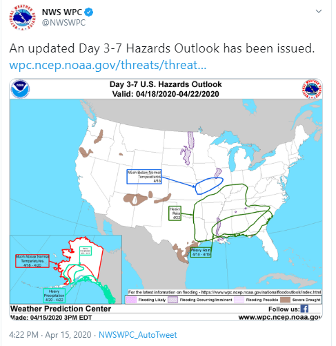
| SPC and WPC began highlighting the possibility of severe weather and flooding via social media well ahead of time | |
April 2020 became a month of note for severe weather in the Southeastern United States. Starting around April 6, guidance trends began to suggest an active period of severe weather for the region. National Weather Service forecasters across the Southeastern U.S., as well as at the Storm Prediction Center (SPC) in Norman, Oklahoma, and the Weather Prediction Center (WPC) in College Park, Maryland, began poring over data and creating their outlooks and forecasts with growing concern. The data were hinting at a disturbing trend for a major severe weather outbreak, including tornadoes and flash flooding, across the southern states for April 11-12. Then, as they were cleaning up from one major outbreak, a second outbreak of flooding rains and severe weather began to look likely in the same locations, just a week later. Forecasters in these offices have been in high gear for most of April, collaborating numerous times to share insight and expertise about the evolving forecast in order to provide accurate and consistent information to our partners and the public. After this second round of severe weather rolled through, it happened again. Four days later, another outbreak of tornadoes and flash flooding moved across virtually the same geographic area, putting forecasters on the front lines again, preparing our partners and public, and continuing to alert the public of the threat until the last warnings were cancelled.
 |
|
 |
 |
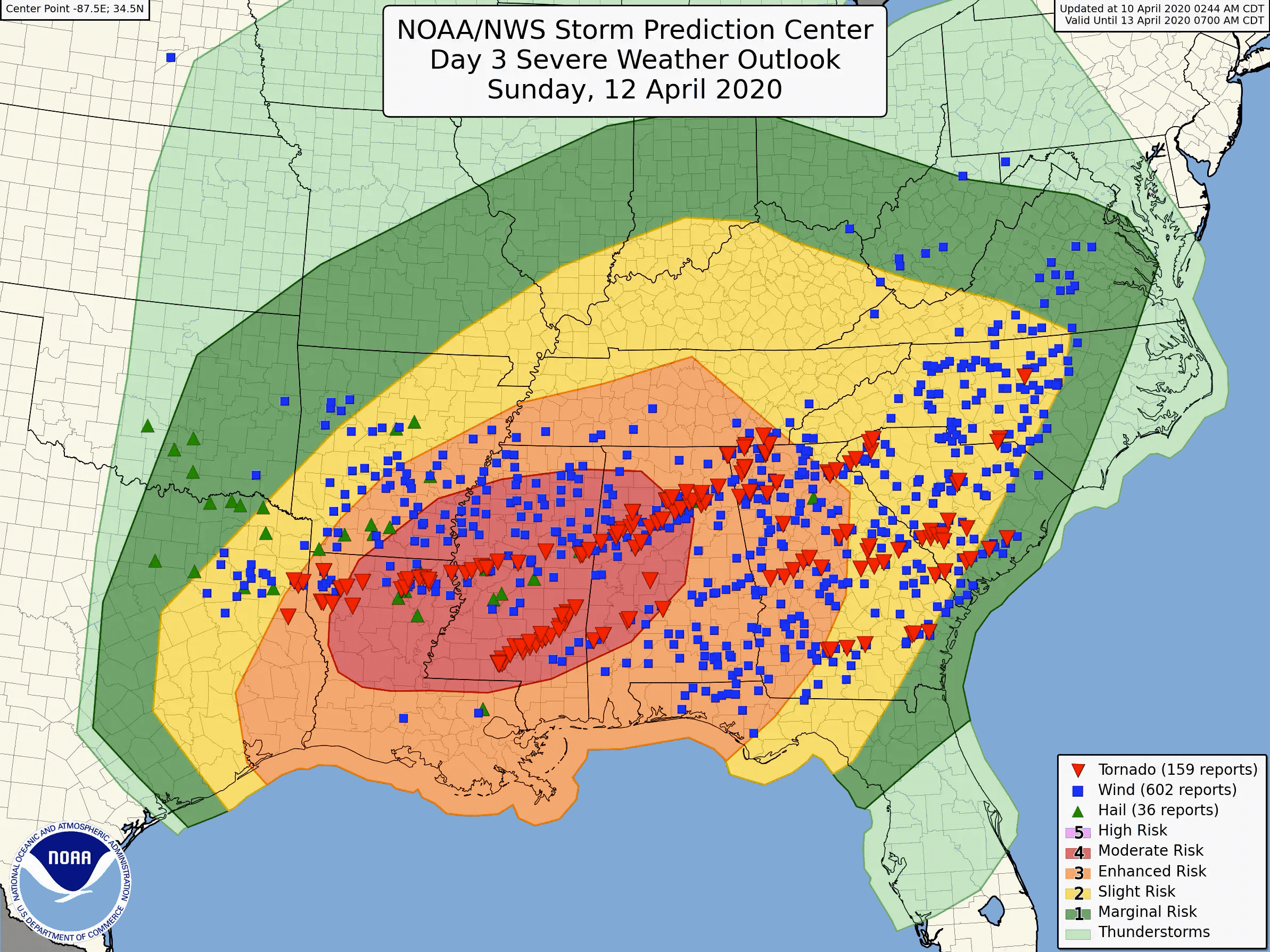
| Evolution of national-scale severe weather outlooks from 3 days before up through the event with initial public reports of severe weather overlaid | |
The National Weather Service’s goal is “one event, one forecast.” 130+ forecast offices, national centers, aviation and river forecast centers all contribute to a collaborative process for both forecasts and messaging in preparing the public when severe weather strikes. This was the case for the events on April 11-13, 18-20, and 22-24. As forecasters began to zero in on the looming threat nearly 96 hours before the first storms formed, the flurry of coordination between local offices and national centers led to a singular force working to prepare the public. The combination of science, skill and collaboration led to a remarkably accurate and consistent series of forecasts and outlooks that, together with our partners in emergency management and media spreading the message, undoubtedly saved lives and property as the storms raged through.
The results of this process were terrific forecasts from over 3 days ahead of the first storms forming. Forecasts stayed consistent in timing, location, and intensity. This advance warning was critical to effective emergency management planning. An absolutely necessary aspect to protecting the public as the initial April 11-12 event saw NWS offices across the southeast issue 237 severe warnings and resulted in over 1,000 severe weather reports. Included in that total were 182 tornado reports, featuring two long-tracked supercells which produced strong tornadoes while moving through Louisiana and Mississippi. During the April 18-19 storms, NWS Offices issued another 141 severe weather warnings and SPC received another 345 preliminary reports of severe weather. This event saw 19 tornadoes, including another powerful EF-4 in Mississippi. The third event tracked from Eastern Texas to the East Coast on April 22-24 with a trail of 389 severe weather warnings which resulted in 400+ severe reports. Tornadoes again caused major damage in Oklahoma and a fourth long-tracked supercell that produced significant tornado damage along a 200+ mile long path through TX, LA, and MS.
 |
 |
|
Excessive rainfall and flood outlooks (left) and Precipitation forecasts and verification (right) for the April 12-13 (top) and April 19-20 (bottom) events. |
 |
The vast majority of these severe weather reports fell within the area highlighted at greatest risk from days ahead of time. WPC forecasters were no less accomplished. The bulk of flash flood warnings and reports, and the band of heaviest rainfall in central Alabama and Georgia, occurred in the area identified well in advance — a remarkable feat for these systems and at these time ranges. "Rainfall forecast skill in these events was nearly double that of typical events,” noted WPC Director Dr. David Novak, “ultimately leading to decisions that protected life and property” Given the accuracy of the forecasts and repeated, consistent messaging of the dangers to the public from both flooding and severe weather, NWS forecasters gave local officials and first responders in the region critical advance notice and time to plan and position themselves to react and respond quickly when necessary and free up resources and shelters to protect their communities.
 |
| Tornado warnings (in red) that came out of one large supercell storm as it tracked across three states the night of April 22nd. Four NWS offices total, one handing it off to the next office with near-seamless warning coverage. |
The  NWS is building a Weather-Ready Nation one event at a time. Our value is not only in the forecasts and warnings we issue, but in the relationships and trust that we’ve built along the way. Following these recent severe weather outbreaks, the NWS office in Birmingham, AL received the following:
“Chris (Darden - Meteorologist-in-Charge),
I want to commend you and your staff for the tremendous work recently during a very active April severe weather pattern.” said JP Dice, Chief Meteorologist at WBRC/Fox6 in Birmingham
“I am particularly pleased with your office’s detailed and very accurate severe weather outlooks. It is clear you and your staff understand the weather in the Birmingham CWA...the accuracy of your tornado warnings is incredible along with the balance of reducing the false alarm rate.”
By building this trust with our partners and the public and by providing them with these accurate and consistent forecasts well in advance of the threat, our communities have the time they need to make decisions and take action to become more resilient and responsive to these extreme, weather, water, and climate events in the future.

