One hundred years ago, residents of Missouri, Illinois, and Indiana experienced a real-life horror that we now refer to as the “Tri-State Tornado.” Today, we’re remembering those lost and sharing ways in which NOAA’s National Weather Service works to prevent another tragedy of this magnitude.
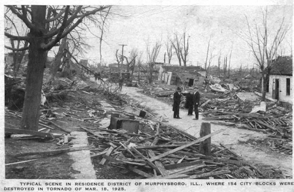 |
| The aftermath and destruction from the Tri-State Tornado. Source: Jackson County Historical Society, Murphysboro, Illinois. |
On March 18, 1925, thousands of lives changed forever when a tornado tore a 219-mile path of destruction across the tri-state, killing almost 700 people and injuring an additional 2,000. The tornado damaged 15,000 homes in addition to outbuildings and other infrastructure. The hardest-hit was Murphysboro, Ill.
In the days following the tornado, the St. Louis Post-Dispatch described the aftermath with chilling details:
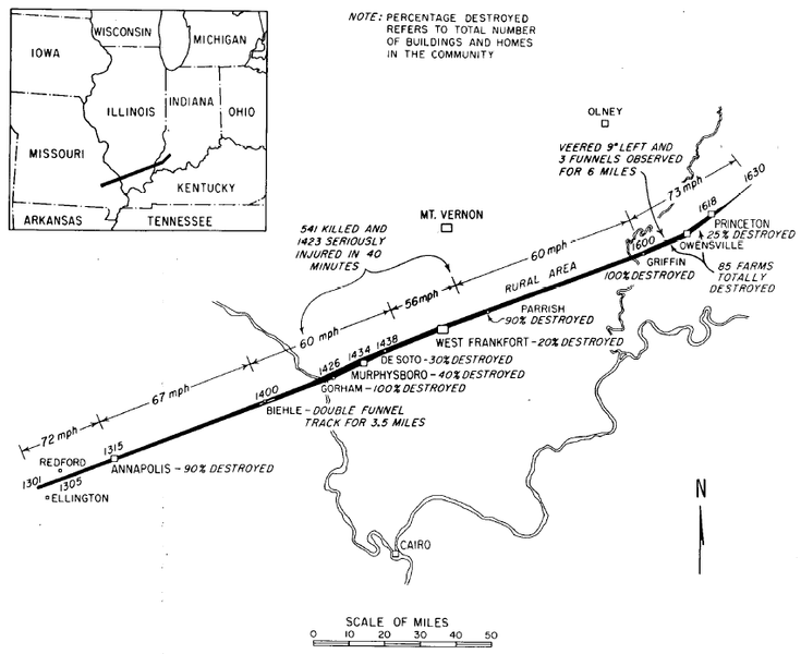 |
| The 1925 Tri-State Tornado track from Missouri to Indiana. Source: Illinois State Water Survey |
Preventing another tragedy
The National Weather Service (NWS) has come a long way since 1925, when it was known as the Weather Bureau.
The most noteworthy changes occurred during an eight year period in the late 1980s to the mid-1990s, when the agency went through a modernization effort. At that time, NWS introduced new technology to improve tornado detections, such as weather observations via Automated Surface Observing Systems, Next Generation Weather Radars placed in strategic places throughout the country, a new series of satellites and advanced computer systems. All of these technologies, along with the establishment of the NOAA Storm Prediction Center, has significantly and steadily boosted the agency’s ability to detect and warn U.S. communities of tornado threats.
Unlike in 1925, today NWS is able to provide severe weather outlooks up to seven days in advance. The average warning lead time for major tornadoes (EF-3 or greater) is just shy of 20 minutes, based on data from 2008-2024. Compare that to one hundred years ago, when the Tri-State tornado caught dozens of communities in its path by surprise. In addition, the agency’s probability of detecting a tornado averages to about 95%.
On the Horizon - Improvements Ahead for Tornado Detection and Warning
NWS is developing plans for a new generation of radars to further improve the lead times and accuracy of tornado warnings. Since the existing NEXRAD radars are at the end of their lifespan, the Radar Next program will develop and deploy the next-generation of weather radars as the nation’s need for accurate forecasts with more advanced lead times increases.
Resources:
NWS Paducah - new StoryMap and updated website on the Tri-State tornado
NWS Heritage - The Tri-State Tornado of 1925
Media Contact: Michael Musher, NWS Public Affairs, michael.musher@noaa.gov

