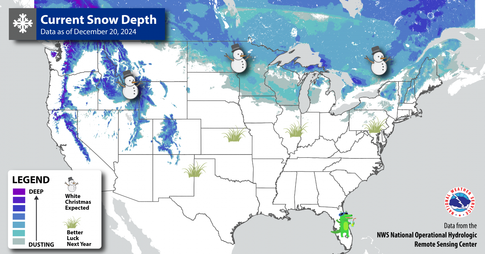
The 2024 holiday season features a rare occurrence of Christmas Day falling on the first day of Hanukkah - which could mean even more folks will be in the air and on the roads than usual. And this time of year, the weather can be downright frightful!
Here’s the day-by-day breakdown of what to expect for your holiday travels:
 |
| Areas most likely to have snow on the ground this Christmas. |
Saturday: Big chill in the High Plains
An atmospheric river is set to bring more rain and high elevation snow to the Pacific Northwest starting on Saturday. Meanwhile, a sprawling area of Arctic high pressure will funnel very cold air toward the Great Lakes and Northeast. High temperatures will be in the teens and twenties from New England to the northern Plains. Extra travel time is advised in the Northeast and Midwest, as an offshore storm could bring a dusting of snow to cities along the I-95 corridor. Lake effect snow showers could also cause slippery spots on the roads from western New York from northeast Ohio. But warm weather lovers in the southern Rockies and Southwest will rejoice with high temperatures expected to be 10-20 degrees above normal.
Sunday: Western storms a-brewin’
The storm that began on Saturday will push farther inland on Sunday, bringing a better chance for heavy snow to the northern Cascades and Rockies. Flooding is possible in coastal portions of northern California on Sunday as the Pacific Northwest storm continues to move onshore. It stays cold in the Northeast and mid-Atlantic, and will be dry from New England to the front range of the Rockies.
Monday: Precipitation plaguing the Northwest
Storm systems continue to bring rounds of precip to the Pacific Northwest, but skiers might be disappointed, as most of it will fall as rain. Snow will be confined to elevations 4,500 feet or higher. The western Great Lakes states, however, are likely to receive another round of snow. Light to moderate accumulations are possible from Chicago northward to the upper peninsula of Michigan.
Tuesday (Christmas Eve): Want a white Christmas? Head north
Rain continues to plague the West Coast, spreading southward to southern California by Tuesday. The system that brought snow to the western Great Lakes on Monday will push southeastward, leading to rain in the Ohio Valley and even a few thunderstorms in the southern Plains. Meanwhile, another shot of snow is possible in the Northeast, with some towns away from the coast picking up 1”-3” by the time Santa makes his rounds. However, major roads such as I-95 are forecast to stay dry.
No matter where you are in the USA, you can always get the updated forecast from your local Weather Forecast Office by going to weather.gov and typing your city or ZIP code.
An early look at the outlook for New Year’s Eve is available from NOAA’s Climate Prediction Center in their 6-10 Day Outlook, and the full story will appear on noaa.gov on December 26. Follow your local NOAA National Weather Service forecast office on social media for the latest weather information in your area.
Happy Holidays!