July 16, 2024 – As we prepare for the peak of wildfire season in the U.S., the National Weather Service (NWS) reminds wildland fire managers that we have tools to help you monitor and fight wildfires. Whether it is a prescribed burn, ground fire or crown fire, fire managers can use this information to make decisions on how best to combat fires and keep the public safe.
Fire weather forecasters
The NWS issues Fire Weather Outlooks for the next eight days. These outlooks show areas where pre-existing fuel conditions, combined with forecast weather conditions, may result in a significant threat of wildfires.
Our Fire Weather Program supports land managers and firefighters who mitigate and respond to fires. Our weather forecasts are designed to highlight times and locations where a fire may be exceptionally hard to control. For example, we offer Red Flag Warnings, which mean warm temperatures, very low humidities and stronger winds are ongoing or expected to produce an increased risk of fire danger in 12 to 24 hours for specific locations.
Need a fire weather Spot Forecast? Land managers can request a site-specific, localized forecast for prescribed burns and wildfires to assess a potential threat. NWS recently updated this tool and will deliver additional enhancements to the application later this year. Learn more about the new Spot Forecast tool.
For federal and select state large wildfires, onsite weather forecasting support to firefighters is critical. An NWS Incident- Meteorologist (IMET) can be deployed to your incident command post. IMETs arrive on scene within 12 to 24 hours after activation and can serve up to 14 consecutive days before being relieved by another IMET.
Satellites
Satellite-based fire detection has improved significantly with NOAA’s next generation Geostationary (GOES) satellites and the Joint Polar Satellite System. Some NWS offices support hotspot notification text messages to emergency managers when they are able to identify hotspots, detect rapid intensification of a fire, or predict dangerous wind shifts.
GOES’s lightning mapper is enabling earlier awareness of ground lightning strikes and potential fire starts. The Next Generation Fire System (NGFS) is under development at NOAA to support satellite-based fire detection to complement fire detection services.
 |
| Multiple wildfires in Northern California captured by NOAA’s GOES satellite in 2023. Satellites can provide information about the location, size, temperature, and power output of fires, which can help guide firefighting, emergency operations and evacuations. (Credit: NOAA) |
Forecast models
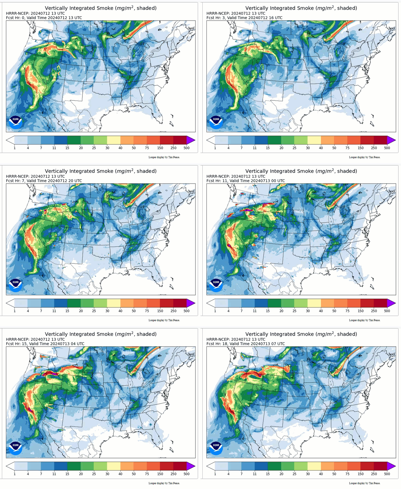
Wildfire smoke poses health hazards. NWS’s High-Resolution Rapid Refresh–Smoke (HRRR-Smoke) and new experimental Rapid Refresh Forecast System-Smoke (RRFS-Smoke) computer models predict where wildfire smoke will go for the next 36 hours. The HRRR-Smoke and RRFS-Smoke provide fire managers and air quality agencies with valuable decision-making information.
 |
| NWS HRRR-Smoke model forecasts smoke movement from wildfires in the Western U.S. and Canada, July 12, 2024 (Credit: NOAA) |
Partnerships
Local emergency officials disseminate evacuation orders when wildfires threaten a community. Here are two dissemination methods officials may consider using:
The Wildland Fire Potential Outlook, produced by the National Interagency Fire Center, provides monthly and seasonal outlooks of expected fire activity.
Post-fire debris flow flooding is such a significant problem that the NWS collaborates with the U.S. Geological Survey and interagency partners to better serve the population with flash flood watches and warnings. Locations downhill and downstream from burned areas are highly susceptible to flash flooding and debris flows, especially near steep terrain. Rainfall that would normally be absorbed into the soil runs off extremely quickly after a wildfire, as burned soil can be as water-repellant as pavement.
NOAA’s NWS is a key member of the Wildland Fire Agencies. Our role is to predict the weather that fuels and spreads fire and smoke on the ground. Our accurate and timely forecasts and products are crucial to the success of the wildland fire missions. As we prepare for the next wildfire, we hope for the best, but plan for the worst. Bookmark these links today for quick access later.
Learn more about how NOAA supports wildfire science and response through the NOAA Wildfire Portal.
Media contact: Maureen O’Leary, maureen.oleary@noaa.gov