By Dennis Feltgen, National Hurricane Center
- Storm Surge Watch/Warning becomes operational

Beginning with the 2017 hurricane season, the National Weather Service (NWS) will issue storm surge watches and warnings to highlight areas along the Gulf and Atlantic coasts of the continental United States that have a significant risk of life-threatening inundation from a tropical cyclone, subtropical cyclone, post-tropical cyclone, or a potential tropical cyclone. Storm surge is often the greatest threat to life and property from a tropical cyclone, and it doesn’t always occur at the same times or locations as a storm’s hazardous winds. In addition, while in most cases coastal residents can remain in their homes (or in a secure structure nearby) and be safe from a tropical cyclone’s winds, evacuations are generally needed to keep people safe from storm surge. Having separate warnings for these two hazards will save lives by better identifying the specific tropical cyclone hazards communities face, and by enhancing public response to instructions from local officials.
The storm surge watch/warning areas are determined by a collaborative process between the NHC and local NWS Weather Forecast Offices (WFOs). The primary objective guidance will be P-Surge, an ensemble-based probabilistic system driven by the SLOSH model, the latest NHC official tropical cyclone forecast, and the typical historical errors associated with NHC forecasts. Forecaster confidence, continuity from advisory to advisory, and other subjective factors will also help determine the areas placed under a watch or warning.
The definitions for the new storm surge watch and warning are:
Storm Surge Watch: The possibility of life-threatening inundation from rising water moving inland from the shoreline somewhere within the specified area, generally within 48 hours, in association with an ongoing or potential tropical cyclone, a subtropical cyclone, or a post-tropical cyclone. The watch may be issued earlier when other conditions, such as the onset of tropical storm-force winds, are expected to limit the time available to take protective actions for surge (e.g., evacuations). The watch may also be issued for locations not expected to receive life-threatening inundation, but which could potentially be isolated by inundation in adjacent areas.
Storm Surge Warning: The danger of life-threatening inundation from rising water moving inland from the shoreline somewhere within the specified area, generally within 36 hours, in association with an ongoing or potential tropical cyclone, a subtropical cyclone, or a post-tropical cyclone. The warning may be issued earlier when other conditions, such as the onset of tropical storm-force winds, are expected to limit the time available to take protective actions for surge (e.g., evacuations). The warning may also be issued for locations not expected to receive life-threatening inundation, but which could potentially be isolated by inundation in adjacent areas.
The Potential Storm Surge Flooding Map, which became operational in 2016, will continue to be issued in 2017. This product provides quantitative information on the storm surge hazard associated with tropical cyclones, highlighting geographical areas where inundation from storm surge could occur and the height above ground that the water could reach. The map depicts inundation levels that have a 10-percent chance of being exceeded, which can be thought of as representing a reasonable worst-case scenario for any individual location. The first map will usually be issued at the same time as the initial hurricane or storm surge watch or warning, but can be issued at other times as appropriate, including for some tropical storm watches or warnings. The map is based on the latest forecast track and intensity for the tropical cyclone, and takes in to account likely forecast errors. The map is subject to change every six hours in association with each new NHC full advisory package, and is generally available about 60 to 90 minutes following the advisory release.
- Issuance of Watches, Warnings, and Advisories for Potential Tropical Cyclones
In 2017, NHC will have the option to issue advisories, watches, and warnings for disturbances that are not yet a tropical cyclone, but which pose the threat of bringing tropical storm or hurricane conditions to land areas within 48 hours. Under previous longstanding NWS policy, it has not been permitted to issue a hurricane or tropical storm watch or warning until after a tropical cyclone had formed. Advances in forecasting over the past decade or so, however, now allow the confident prediction of tropical cyclone impacts while these systems are still in the developmental stage. For these land-threatening “potential tropical cyclones”, NHC will now issue the full suite of text, graphical, and watch/warning products that previously has only been issued for ongoing tropical cyclones.
Potential tropical cyclones will share the naming conventions currently in place for tropical and subtropical depressions, with depressions and potential tropical cyclones being numbered from a single list (e.g., “One”, “Two”, “Three”, …, “Twenty-Three”, etc.). The assigned number will always match the total number of systems (tropical cyclones, subtropical cyclones, or potential tropical cyclones) that have occurred within that basin during the season. For example, if three systems requiring advisories have already formed within a basin in a given year, the next land-threatening disturbance would be designated “Potential Tropical Cyclone Four”. If a potential tropical cyclone becomes a tropical depression, its numerical designation remains the same (i.e., Potential Tropical Cyclone Four becomes Tropical Depression Four).
Potential tropical cyclone advisory packages (i.e., the Public Advisory, Forecast/Advisory, Discussion, Wind Speed Probability Product, etc., along with all the standard tropical cyclone graphics) will be issued at the standard advisory times of 5 AM, 11 AM, 5 PM, and 11 PM EDT. Three-hourly Intermediate public advisories will be issued for potential tropical cyclones at 2 AM, 8 AM, 2 PM, and 8 PM EDT when watches or warnings are in effect. The product suite will include a five-day track and intensity forecast just as is done for ongoing tropical cyclones. In addition, the Potential Storm Surge Flooding Map and Storm Surge Watch/Warning graphic would be issued for these systems when appropriate.
Advisory packages on potential tropical cyclones will be issued until watches or warnings are discontinued or until the threat of tropical-storm-force winds for land area sufficiently diminishes, at which point advisories would be discontinued. However, if it seems likely that new watches or warnings would be necessary within a short period of time (say 6-12 hours), then advisories could continue for a short time in the interest of service continuity. Once a system becomes a tropical cyclone, the normal rules for discontinuing advisories will apply. Potential tropical cyclone advisories will not be issued for systems that pose a threat only to marine areas.
Because NHC will be issuing its normal graphical products depicting the five-day forecast track and uncertainty cone for potential tropical cyclones, to avoid potential confusion the Graphical Tropical Weather Outlook will no longer display a formation area for these systems.
- Experimental Time of Arrival of Tropical-Storm-Force Winds Graphic
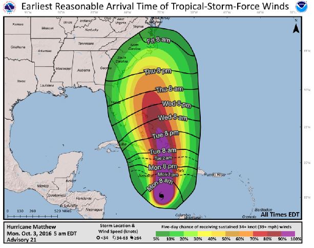
The arrival of sustained tropical-storm-force winds is a critical planning threshold for coastal communities, as many preparedness activities become difficult or dangerous once winds reach tropical storm force. Frequently, this timing is estimated using the deterministic NHC track, intensity, and wind-field (size) forecasts, but such an approach doesn’t account for forecast uncertainty, and communities can be caught off guard if a storm speeds up or grows in size beyond what was forecast. To provide guidance on when users should consider having their preparations completed before a storm, NHC will begin issuing in 2017 experimental Time of Arrival of Tropical-Storm-Force Winds graphics. These graphics will be driven by the same Monte Carlo wind speed probability model that is currently used to determine the risk of tropical-storm- and hurricane-force winds at individual locations – a model in which 1000 plausible scenarios are constructed using the official NHC tropical cyclone forecast and its historical errors.
The primary graphic displays the “earliest reasonable” arrival time, identifying the time window that users at individual locations can safely assume will be free from tropical-storm-force winds. Specifically, this is the time that has no more than a 1-in-10 (10%) chance of seeing the onset of sustained tropical-storm-force winds – the period during which preparations should ideally be completed for those with a low tolerance for risk. A second graphic will show the “most likely” arrival time – that is, the time before or after which the onset of tropical-storm-force winds is equally likely. This would be more appropriate for users who are willing to risk not having completed their preparations before the storm arrives.
Users will also be able to overlay the standard wind speed probabilities, providing a single combined depiction of the likelihood of tropical-storm-force winds at individual locations, along with their possible or likely arrival times.

