 |
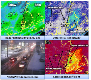
| During a recent nor’easter event, forecasters at the NWS Boston forecast office relied on several dual-pol radar products to help determine where the rain/snow line was located as the storm moved through the area. |
Throughout the NWS Eastern Region, dual-pol technology has been proving itself time and time again during weather events that have both challenged NWS forecasters, but also armed them with improved confidence, thanks to the new technology.
Back in August 2011, the NWS Doppler radar in Newport/Morehead City, N.C. — one of the first five operational NWS radars to have dual-pol technology — provided forecasters with unprecedented views of Hurricane Irene as it moved over the Outer Banks. It was the first time a hurricane had been scanned by an operational dual-pol radar. The dual-pol precipitation estimates for Hurricane Irene in eastern North Carolina seemed to perform better than the existing precipitation estimations, which are based on radar reflectivity alone. In fact, the NWS Newport/Morehead City, N.C., forecast office compared both storm total precipitation graphics to their network of rain gauges. Preliminary results after the storm showed that the dual-pol product performed better than the older product — in some cases, several inches better.
More recently, an unexpected extreme rainfall event occurred on August 25, 2012, across southeast Virginia, northeast North Carolina, and the lower Maryland Eastern Shore. The event unfolded as an upper low — moving north from the Southeast Coast to the Mid-Atlantic region — tapped into moisture from Tropical Storm Isaac. Dual-pol rainfall estimates were far superior to legacy precipitation estimates and were vital as forecasters at the NWS Wakefield, Va., forecast office reacted to a rapidly-developing situation during the early morning hours of August 25, when several locations experienced urban flash flooding, due to rainfall rates as high as 4-5 inches per hour. A few days later, on August 28, a nearly stationary line of showers and thunderstorms developed from South-Central Virginia through Hampton Roads ahead of a weak cold front. These showers and thunderstorms developed in a similar airmass to the August 25 event, and excessive rainfall rates and flash flooding occurred. Again, dual-pol rainfall estimates provided a realistic representation of real time rainfall amounts.
Several offices in Eastern Region were affected by a winter storm on January 20-21, 2012. One of the concerns with the storm was the possibility of mixed precipitation, with sleet being the primary concern. With the bulk of the precipitation occurring overnight, real-time reports were few and far between. However, by looking at the correlation coefficient provided by the recently-upgraded dual-pol radars, the forecasters on shift at both the NWS Pittsburgh, Pa., and New York, N.Y., forecast offices were able to detect areas where they determined — with a high confidence level — that sleet was falling. Forecasters at both offices observed the clear signs of a precipitation-type transition in the dual-pol variables, which boosted their confidence as to where snow was changing to sleet and/or freezing rain.
At the NWS Boston forecast office, forecasters have made dual-pol radar products part of their routine assessment of various weather scenarios. During the cool season, for example, dual-pol radar products have become an important part to help discriminate precipitation type. A good example of this occurred on November 7-8, 2012, as a coastal storm brought snow to much of interior southern New England and rain to coastal locations. During the afternoon and evening, a coastal front set up across Rhode Island and eastern Massachusetts. Snow fell to the west of the boundary where temperatures fell into the 30s, while rain fell to the east where temperatures held in the 40s. Relying on the dual-pol radar’s various products, forecasters were able to clearly identify the rain-snow line just northwest of the radar’s location. By using these dual-pol products, forecasters were able to accurately track the slow southward progress of the rain-snow line that evening, which helped forecasters provide effective short term forecasts to decision makers.
The successful completion of dual-pol radar upgrades in Eastern Region — and at NWS offices across the country — represent another step in the efforts by NOAA and NWS to build a Weather-Ready Nation.