Severe thunderstorms are forecast through this weekend along a slow moving cold front and secondary storm system that will impact areas from the southern Plains to the Great Lakes. Large hail and isolated damaging wind gusts are the main threats with these storms along with a risk for heavy to excessive rainfall which could bring flooding. Read More >
| Waterspouts and Tornadoes March 2011 | ||||||
|
During the month of March, the "Storm Door" opened for much of California as several storms brought hazardous weather to the region. A plethora of weather was observed from floods to mudslides and waterspouts to tornadoes. First let's define a waterspout and a tornado:
Even though tornadoes and waterspouts are somewhat rare in the San Francisco Bay Area they do occur. Over the past 20 years 23 tornadoes have been reported in the Monterey WFO County Warning Area (CWA). The vast majority of these tornadoes were ranked EF0 to EF1 on the Enhanced Fujita Scale. However, on May 15, 1998, a F2 (original Fujita Scale) occurred in Sunnyvale, CA causing and estimated 3.8 million dollars in damage. Generally speaking, unlike 'Tornado Alley', most tornadoes in the Monterey WFO CWA are associated with low topped/mini supercells (<~15k feet) or along narrow cold frontal rainbands. Given the shallow nature of these storms, it should be noted that in some cases tornadic storms cells can be hard to detect on WSR-88D KMUX, which is at an elevation of 3,469 feet MSL. That is why the general public and trained storm spotters are invaluable in relaying severe weather reports to the National Weather Service. |
||||||
|
March 18, 2011
|
||||||
|
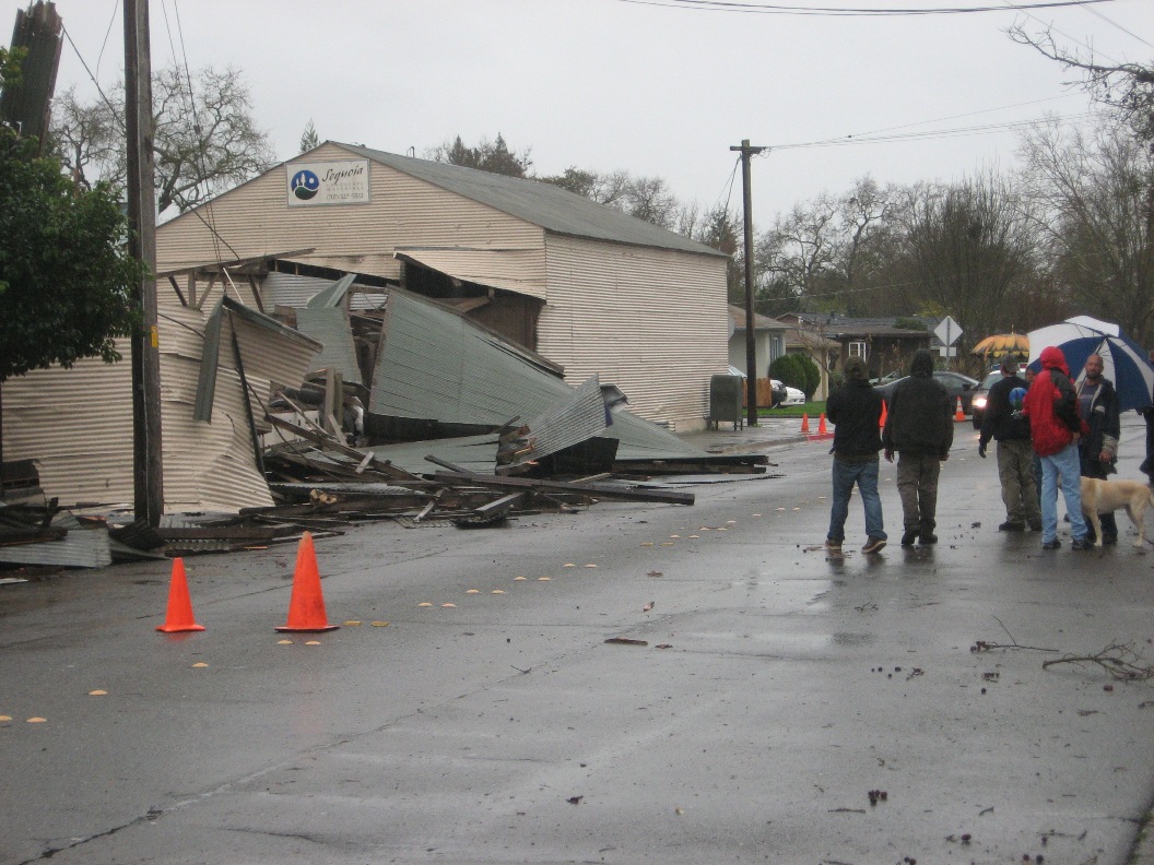
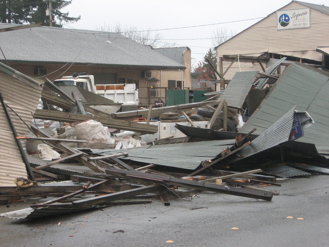
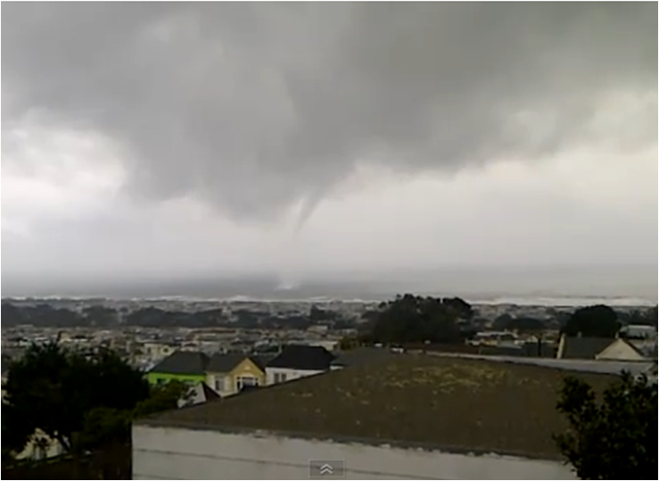
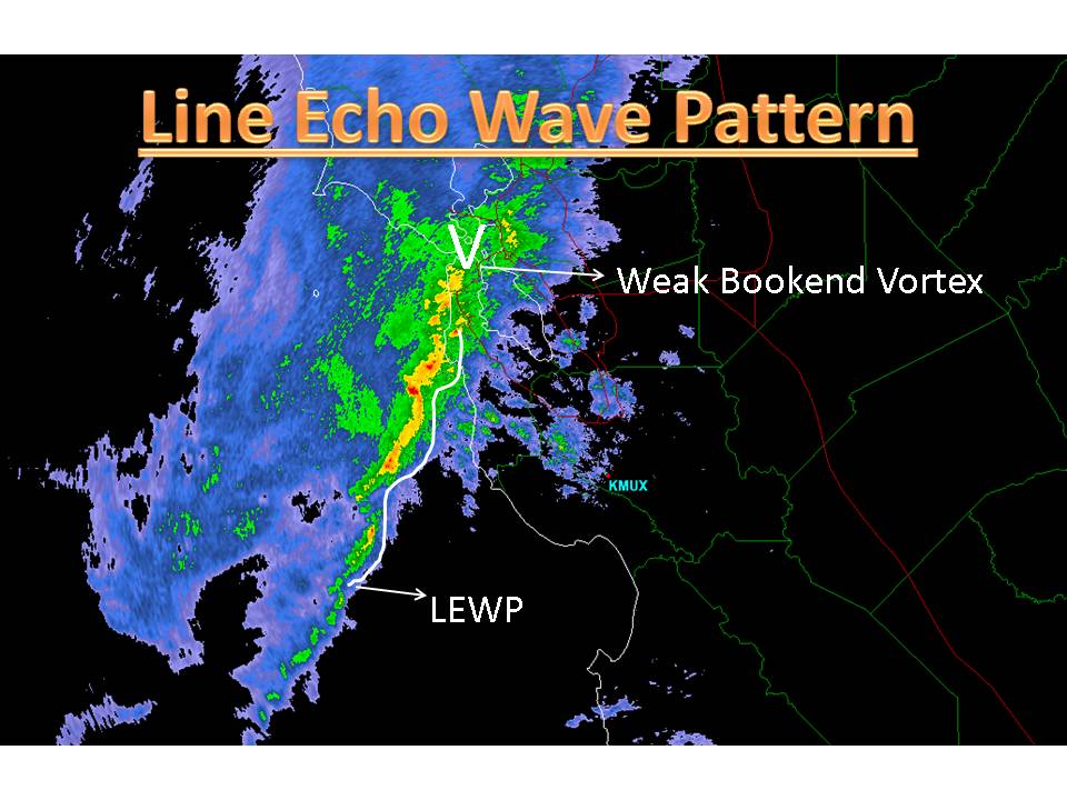
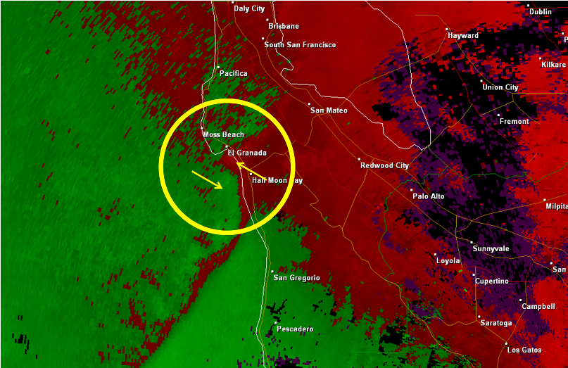
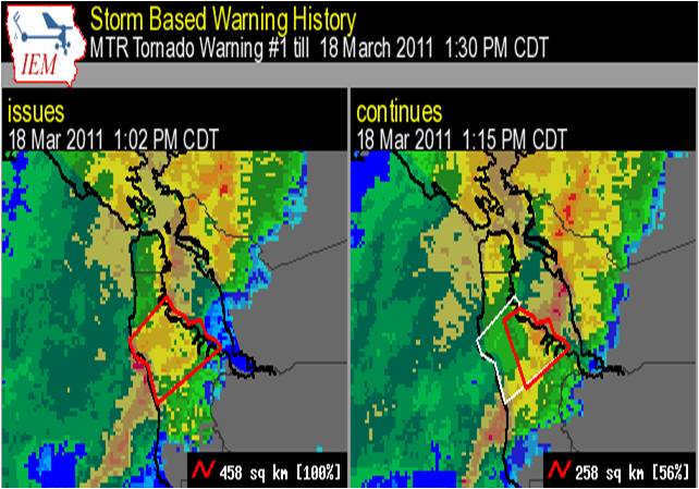
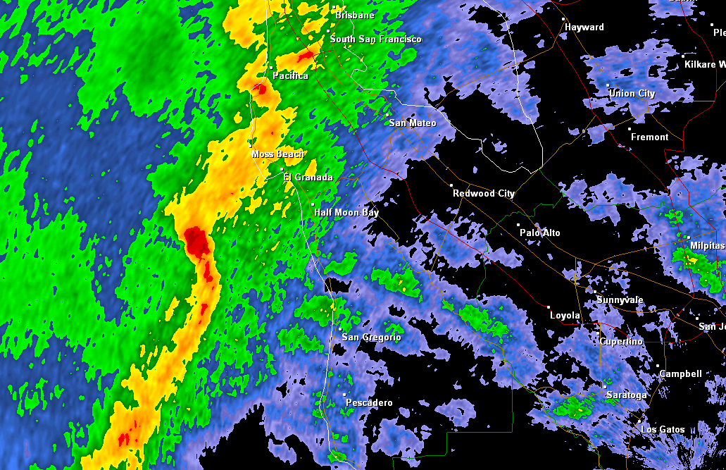
A vigorous cold front moved through the San Francisco Bay Area on, March 18, 2011 bringing a round of severe weather with damaging winds, waterspouts, heavy rainfall and even a reported tornado. The frontal boundary first impacted the North Bay during the early morning with heavy rain and gusty winds reported. As the boundary moved through Santa Rosa a brief spin up occurred, causing damage to a metal building and bending a gate (see pics below). This 'spin up' was later classified as an EF1 tornado with estimated winds 86-110 mph . Farther south, the frontal boundary began to intensify as it moved toward the San Mateo Coast. In fact, the line of convective storms formed a LEWP(line echo wave pattern) . LEWPs are known for producing damaging winds and even tornadoes. Ahead of the LEWP a few discrete cells developed with weak rotation observed on radar. One person from the general public even filmed a discrete cell with a waterspout off the coast of Ocean Beach.
About two hours later the convective line began to show embedded storm cells with rotation. The storm cell rotation was strong enough that the National Weather Service in Monterey issued a Tornado Warning at 11:02 AM PDT. The Tornado Warning was for portions of Western San Mateo County.
Despite a storm cell with decent rotation and a Tornado Warning, no tornado was reported. However, there were a few reports of funnel clouds from the general public. |
||||||
| March 23, 2011 | ||||||
|
During the early morning hours of March 23, 2011 an area of low pressure was located off the coast of Northern California with a cold front extending southward. Later that morning, the cold front moved through the Bay Area bringing periods of heavy rain and high winds. Behind the cold front the airmass became more unstable due to cold air aloft and surface heating from the sun. As a result, scattered showers and even isolated thunderstorms developed. One particular cell developed off the Big Sur coast, which produced a spectacular waterspout (see pics below). The storm cell was detected by the KMUX radar, but at this distance from the radar the lowest radar slice is ~8,600 ft AGL. In addition, the estimated Echo Top (ET) for that cell was ~15,000 ft AGL. That means, a good portion of that cell was not even being sampled by the radar. Therefore, it should not be surprising that a microscale feature, like a waterspout, is not captured well on the KMUX radar. Notice how the velocity image below shows no rotation with the cell as it approaches the coast. Fortunately, the cell dissipated as it moved inland and there were no reports of the waterspout making landfall.
|
MMEHLE