Moisture across the northern Plains, upper Great Lakes into northern New England will likely bring a period of snow, sleet and freezing rain through this weekend. Meanwhile, heavy rainfall continues along the Gulf Coast with areas of flooding. Fire weather conditions continue for the areas of the Plains, southern Appalachians into portions of Florida. Severe thunderstorm potential increasing. Read More >
| Record Breaking Rainfall June 23-25 2013 | |||||||
|
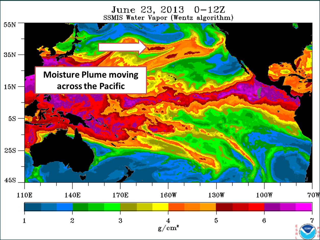
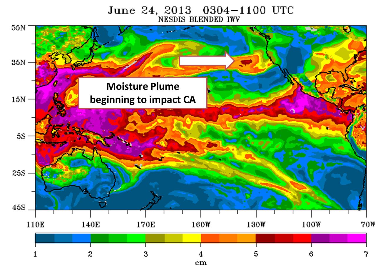
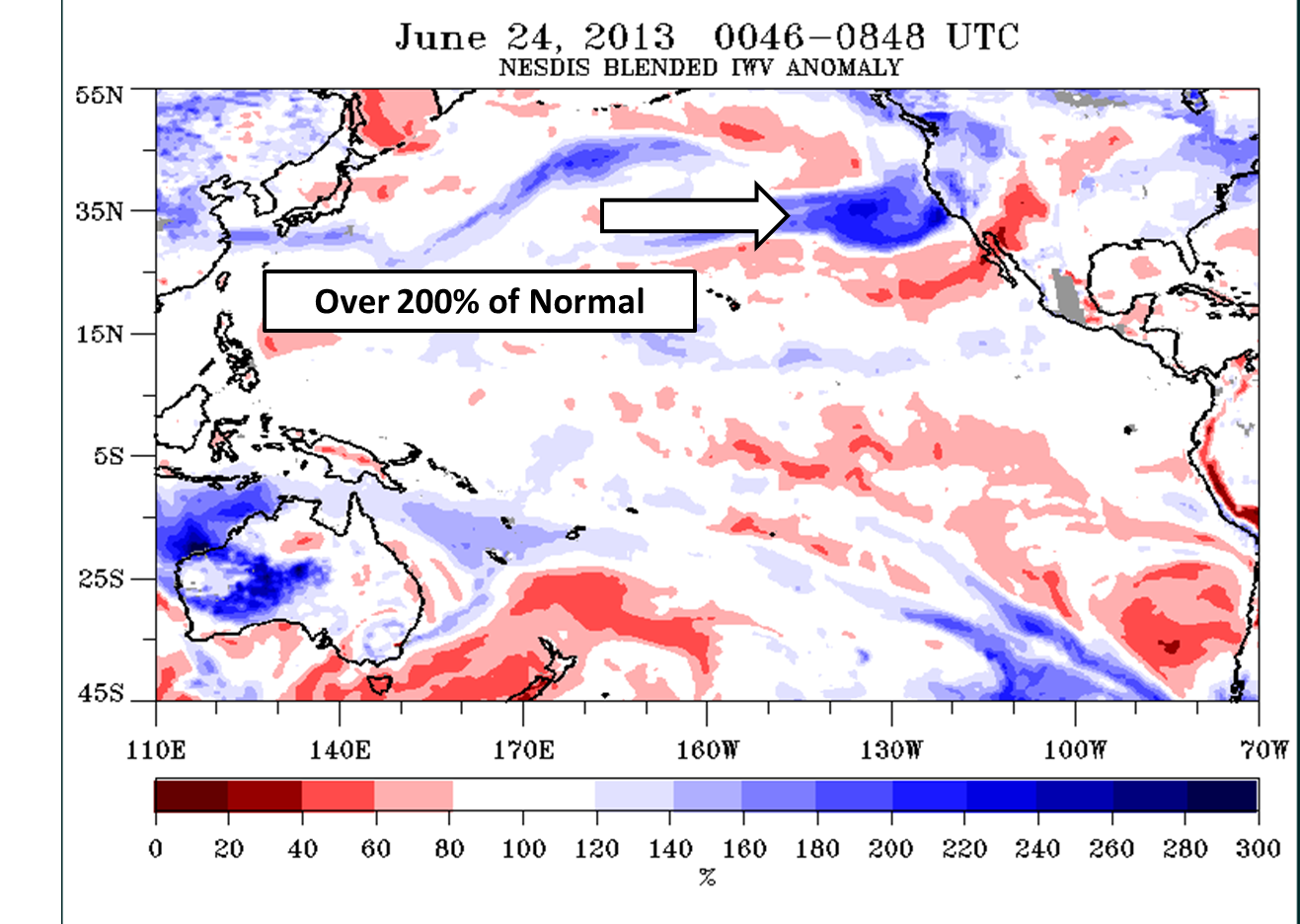
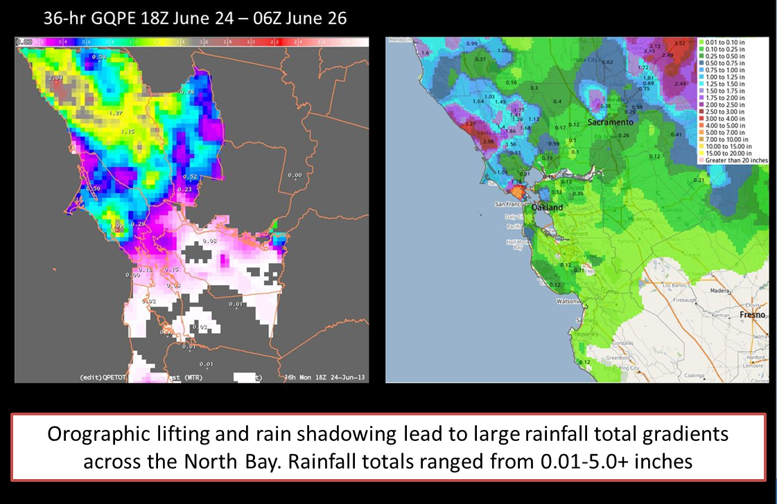
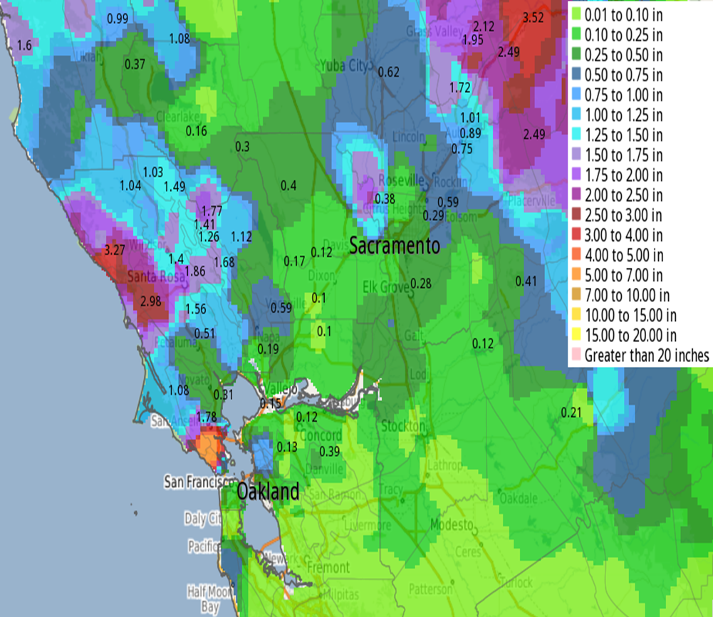
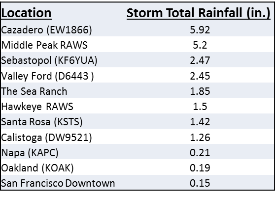
A very moisture rich storm system brought record breaking rainfall to the Bay Area from June 23-25. It is not uncommon for the Bay Area to receive rain in June, but the amount of rainfall that fell in some locations is almost unheard of (over 5 inches!). So the question is, why did it rain so much? A few factors lead to the rainfall: weak shortwave trough moving through, upper level jet stream support, middle level flow perpendicular to the coast , orographic lift along the coastal mountians, but most importantly a very moist airmass streaming in off the Pacific Ocean. The anomamously high moisture plume could be seen traversing the Pacific several days ahead of the rainfall. By June 23rd (see image below), satellite imagery revealed high values of precipitable water knocking on California's door. Precipitable water values observed on satellite were 200-300% of normal(see image below), which goes to show how anonmalous this moisture plume was for June. Less than 24 hours later, these high precipictable water values(see image below)began to interact with weak lift from a shortwave trough, which was the onset for rain over the North Bay. Over the next 48 hours even more moisture streamed in over the North Bay producing persistant, but steady rainfall, especially over the coastal North Bay mountains. Rain tapered off late Tuesday, but by that over five inches of rain fell on Mt Tamalpais and near Cazadero (rainfall totals). It should also be noted that one location in the Northern Sierra reported over eight inches. Other locations along the North Bay Coast also received decent rainfall with one to three inches being reported. Due to orographic lifting and rain shadowing large precipitation gradients developed with some locations measuring several inches and just down the road less than one quarter of an inch. These gradients can easily be seen on the rainfall maps below. Much less rainfall was observed south of the Golden Gate Bridge. |
|||||||
|
|||||||
| Record Event Report (RER) - Rainfall Records | |||||||
 SXUS76 KMTR 260047 CCA
 RERMTR

 RECORD EVENT REPORT
 NATIONAL WEATHER SERVICE SAN FRANCISCO BAY AREA
 0540 PM PDT TUE JUN 25 2013

 ...PRELIMINARY RECORD PRECIPITATION TODAY...

 LOCATION                  NEW RECORD   OLD RECORD    YEAR
 ---------------------------------------------------------
 KENTFIELD                   1.38          0.02       2001
 NAPA                        0.64          0.02       2001
 SAN RAFAEL                  0.33          0.02       2001, 1992
 OAKLAND DOWNTOWN            0.19          0.07       2001
 LIVERMORE                   0.01          0.00

 NOTE: KENTFIELD AND NAPA 4 PM YESTERDAY THROUGH 4 PM TODAY...OTHER
       SITES ARE MIDNIGHT THROUGH 5 PM AND ARE SUBJECT TO CHANGE
       WITH ADDITIONAL RAINFALL

 $$
|
|||||||
| Public Information Statement (PNS) - Selected Rainfall Totals for various sites | |||||||
PLEASE NOTE THAT THE VALUES LISTED BELOW ARE SLIGHTLY BELOW THE COMPLETE STORM TOTAL
PUBLIC INFORMATION STATEMENT NATIONAL WEATHER SERVICE SAN FRANCISCO CA 1051 PM PDT TUE JUN 25 2013 ...LATEST RAINFALL TOTALS SINCE SUNDAY NIGHT... PLEASE NOTE THESE READINGS INCLUDE MANY DIFFERENT SOURCES AND MAY NOT BE OFFICAL. THE AMOUNTS HAVE NOT BEEN FULLY QUALITY CONTROLLED, SO CAUTION SHOULD BE USED. LOCATION AMOUNT TIME/DATE LAT/LON ...CALIFORNIA... ...ALAMEDA... OAKLAND NORTH RAWS 0.49 1014 PM 06/25 37.87N/122.22W OAKLAND SOUTH RAWS 0.22 1014 PM 06/25 37.79N/122.14W METROPOLITAN INTL APT 0.17 1000 PM 06/25 37.72N/122.22W OAKLAND FIRE STATION 0.12 1009 PM 06/25 37.80N/122.19W ROSE PEAK RAWS 0.08 0538 PM 06/25 37.50N/121.74W CALAVERAS RD RAWS 0.05 0538 PM 06/25 37.55N/121.84W LIVERMORE MUNICIPAL AIRPORT 0.04 1000 PM 06/25 37.69N/121.81W CASTRO VALLEY/ARCADIAN RSVR 0.04 1014 PM 06/25 37.72N/122.10W CASTRO VALLEY/BELLINGHAM DRIVE 0.04 0900 PM 06/25 37.73N/122.06W HAYWARD AIR TERMINAL 0.02 1000 PM 06/25 37.65N/122.11W FREMONT 0.02 0500 PM 06/25 37.54N/122.02W ...CONTRA COSTA... BALD PEAK - TILDEN PARK 0.76 1014 PM 06/25 37.88N/122.21W RICHMOND 0.69 0500 PM 06/25 37.92N/122.38W MOUNT DIABLO PEAK 0.39 1014 PM 06/25 37.88N/121.92W ROCKY RIDGE 0.16 1014 PM 06/25 37.82N/122.06W RODEO FIRE DEPT 0.15 1014 PM 06/25 38.03N/122.27W BLACK DIAMOND RAWS 0.14 1014 PM 06/25 37.95N/121.88W LAS TRAMPAS RAWS 0.13 1014 PM 06/25 37.83N/122.07W ORINDA FIRE STATION 0.13 1014 PM 06/25 37.90N/122.17W CONCORD WASTEWATER PLANT 0.12 0500 PM 06/25 37.98N/122.07W CONCORD BUCHANAN FIELD 0.12 1000 PM 06/25 37.99N/122.06W KREGOR PEAK 0.10 1014 PM 06/25 37.94N/121.89W MALLORY RIDGE RAWS 0.09 1014 PM 06/25 37.82N/121.78W BRIONES RAWS 0.08 1014 PM 06/25 37.93N/122.12W 2 SSE ANTIOCH 0.08 0522 PM 06/25 37.96N/121.78W FLOOD CONTROL HQ 0.08 1014 PM 06/25 37.99N/122.09W MT DIABLO RAWS 0.07 1017 PM 06/25 37.88N/121.91W ST. MARYS COLLEGE 0.06 1014 PM 06/25 37.84N/122.11W BRENTWOOD CORP YARD 0.04 1014 PM 06/25 37.92N/121.68W YGNACIO VALLEY FIRE 0.04 0808 PM 06/25 37.94N/122.03W LOS VAQUEROS RAWS 0.03 1014 PM 06/25 37.79N/121.74W ...MARIN... MIDDLE PEAK RAWS 5.17 1014 PM 06/25 37.93N/122.59W WOODACRE RAWS 1.75 1014 PM 06/25 37.99N/122.64W KENTFIELD 1.45 0500 PM 06/25 37.96N/122.54W BARNABY RAWS 0.96 1014 PM 06/25 38.03N/122.70W BIG ROCK RAWS 0.39 1014 PM 06/25 38.04N/122.57W ...MONTEREY... ANDREW MOLERA 0.12 0500 PM 06/25 36.28N/121.84W BIG SUR RAWS 0.08 1000 PM 06/25 36.24N/121.79W 13 S CARMEL VALLEY VILL 0.08 1000 PM 06/25 36.30N/121.71W ANDERSON PEAK 0.07 1000 PM 06/25 36.18N/121.65W SAN FRANCISCO 0.04 0500 PM 06/25 36.59N/121.86W BLACK CONE 0.04 1000 PM 06/25 36.24N/121.60W SALINAS AP 0.04 1000 PM 06/25 36.66N/121.61W PICO BLANCO 0.04 1000 PM 06/25 36.32N/121.81W 10 SW CARMEL VALLEY VILL 0.04 1000 PM 06/25 36.39N/121.86W FREMONT PEAK 0.04 1000 PM 06/25 36.76N/121.49W NATIVIDAD 0.04 1000 PM 06/25 36.69N/121.63W MOUNT TORO 0.04 1000 PM 06/25 36.55N/121.63W 24 SW GREENFIELD 0.04 1000 PM 06/25 36.05N/121.52W MONTEREY PENINSULA AIRPORT 0.03 0900 PM 06/25 36.59N/121.85W ...NAPA... MT.SAINT HELENA 1.73 1014 PM 06/25 38.66N/122.61W 4 W SAINT HELENA 1.56 1014 PM 06/25 38.49N/122.54W ANGWIN PACIFIC UNION COLLEGE 1.08 1014 PM 06/25 38.57N/122.44W ATLAS PEAK 0.92 1014 PM 06/25 38.43N/122.25W NAPA STATE HOSPITAL 0.66 0500 PM 06/25 38.28N/122.26W MT. GEORGE 0.59 1014 PM 06/25 38.34N/122.20W NAPA R @ LINCOLN BRIDGE 0.59 1014 PM 06/25 38.31N/122.28W NAPA CORP YARD 0.59 1014 PM 06/25 38.31N/122.29W CONN DAM 0.39 1014 PM 06/25 38.48N/122.37W ATLAS PEAK 0.31 0929 PM 06/25 38.47N/122.26W NAPA COUNTY AIRPORT 0.19 1000 PM 06/25 38.21N/122.28W ...SAN BENITO... HOLLISTER 2 0.01 0500 PM 06/25 36.85N/121.42W ...SAN FRANCISCO... SAN FRANCISCO DOWNTOWN 0.14 1000 PM 06/25 37.77N/122.43W ...SAN MATEO... SPRING VLY RAWS 0.72 1018 PM 06/25 37.56N/122.44W HALF MOON BAY 0.35 0500 PM 06/25 37.47N/122.44W LA HONDA RAWS 0.07 1014 PM 06/25 37.31N/122.25W SAN FRANCISCO WSO AP 0.05 1000 PM 06/25 37.66N/122.44W PULGAS RAWS 0.03 1018 PM 06/25 37.48N/122.30W REDWOOD CITY 0.03 1000 PM 06/25 37.48N/122.24W ...SANTA CLARA... MT. UMUNHUM 0.28 1014 PM 06/25 37.16N/121.90W MT. MADONNA 0.08 1000 PM 06/25 37.01N/121.70W SAN JOSE INTERNATIONAL AIRPORT 0.04 1000 PM 06/25 37.36N/121.92W COE PARK 0.04 1014 PM 06/25 37.18N/121.54W LOMA PRIETA 0.04 1000 PM 06/25 37.11N/121.84W MOFFETT FIELD NAVAL AIR STATIO 0.03 1000 PM 06/25 37.42N/122.05W ...SANTA CRUZ... BEN LOMOND RAWS 0.31 1014 PM 06/25 37.13N/122.17W SCHULTIES ROAD 0.16 1014 PM 06/25 37.14N/121.97W SANTA CRUZ 0.13 0800 PM 06/25 36.99N/121.99W DAVENPORT ALERT #1981 0.12 1014 PM 06/25 37.02N/122.19W LAS CUMBRES PEAK 0.12 1014 PM 06/25 37.21N/122.06W BURRELL FIRE STATION 0.11 1014 PM 06/25 37.11N/121.91W BATES CREEK 0.08 1014 PM 06/25 37.02N/121.93W CORRALITOS RAWS 0.05 1014 PM 06/25 36.99N/121.81W BOULDER CK COUNTRY CLUB ALERT 0.04 1014 PM 06/25 37.15N/122.16W BEN LOMOND LANDFILL 0.04 1014 PM 06/25 37.09N/122.08W CORRALITOS CREEK @ FREEDOM 0.04 1000 PM 06/25 36.94N/121.77W WATSONVILLE MUNICIPAL AIRPORT 0.04 1000 PM 06/25 36.94N/121.79W ...SONOMA... OCCIDENTAL 3.07 0500 PM 06/25 38.39N/122.97W SANTA ROSA RAWS 1.55 1014 PM 06/25 38.48N/122.71W HAWKEYE RAWS 1.42 1014 PM 06/25 38.74N/122.84W VENADO 1.40 1000 PM 06/25 38.61N/123.02W SANTA ROSA SONOMA CO AP 1.38 1000 PM 06/25 38.50N/122.81W PETRIFIED FOREST 1.18 1014 PM 06/25 38.58N/122.63W WILLOW BROOK CK PRECIP 1.14 1014 PM 06/25 38.32N/122.61W LICHAU CREEK NR PENNGROVE 1.03 1014 PM 06/25 38.32N/122.64W LIBERTY ROAD 0.71 1014 PM 06/25 38.28N/122.70W PETALUMA @ CORONA RD 0.47 1014 PM 06/25 38.26N/122.66W LA CRESTA PRECIP 0.36 1014 PM 06/25 38.22N/122.65W MIDDLE TWO ROCK ROAD 0.32 1014 PM 06/25 38.24N/122.71W PETALUMA @ D STREET BRIDGE 0.32 1014 PM 06/25 38.23N/122.63W WILSON STREET 0.31 1014 PM 06/25 38.24N/122.63W |
MMEHLE