
Strong winds and low humidity will create elevated to critical fire weather conditions across the Southern Plains on Thursday. Strong to severe thunderstorms are forecast in the Ohio Valley late Thursday into Friday morning, with the strongest storms capable of producing very large hail, damaging winds, and a few tornadoes. Read More >
 |
|
| Question #1: Where does the fog in San Francisco come from? |
|
| Answer: The famous San Francisco fog created by the lateral transfer of warm air over the cooler water of the California Current, which flows just off the coast. The water is often cool enough to lower the temperature of the air to the dew point, causing fog to form. | |
|
|
|
| Question #2: I grew up in New England, where it rains or snows year round. It has always baffled me that not a single storm system can make it here with precipitation for months in the spring and summer. What causes the Pacific Ocean storm track to weaken and lift north every year, causing a normal six month “drought”? What triggers it to come back in the fall? |
|
| Answer: The storm track intensity is primarily based on the difference in temperature across the hemispheres from the poles to the equator. It's most pronounced in the winter season and less pronounced in the summer. The jet stream migrates south in latitude in the winter (strengthens) and retreats northward in the summer (weakens). All of this is to restore temperature imbalances which ends up causing storms to develop and decay. New England's weather in the summer months are primarily driven by cold fronts (weak to strong) routinely moving out of Canada and bumping into warmer, humid, unstable air thus causing either actual storms with nearly widespread rain and/or thunderstorm lines that can occur well into spring and summer (thunderstorms at least). Humidity in terms of dew point temperature can be significantly higher in the northeast thus potentially adding way more fuel to thunderstorm development. In California, the summer months are influenced by much more stable and drier (except immediate coast with low clouds/fog) with only weak cold fronts, if any at all, moving in from time to time, thus the weather is basically dry with some coastal clouds/fog. Why our cold fronts are much weaker is because they are greatly modified by the ocean whereas New England's cold fronts are not. Thunderstorm activity is primarily confined to the Sierra Nevada thanks to higher elevation and relatively warmer, unstable air. For the coast our only chance of seeing thunderstorms is when the monsoonal pattern extends far west and moves relatively more humid, unstable air to the coast. It needs to happen when a weak upper low is moving in from the west. This helps initiate the thunderstorms. In the past we have seen this combination produce some thunderstorm activity but overall the summer pattern is usually very hot and dry inland, low clouds/fog at the coast. Also one more possible way of getting rain in the summer in Ca is when a decaying tropical system moves north from the Baja area. By the time it gets here it's only a batch of moisture producing some tropical showers (winds no longer a factor). |
|
|
|
|
|
Question #3 |
|
| Answer: California’s Record Rainfall for a 24-hour period was 26.12 inches occurring January 22-23, 1943, at Hoegees Camp in Los Angeles County (18 miles north of Los Angeles City Hall in the San Gabriel Mountains). | |
|
|
|
| Question # 4 What is the difference between Universal Time and Pacific Daylight Time? |
|
| Answer: Coordinated Universal Time (UTC) formerly called Greenwich Mean Time (GMT), also referred to as Zulu Time by the U.S. military is the time at the prime meridian (0° longitude), and used by numerous agencies worldwide including the National Weather Service. UTC uses a 24-hour system of time notation. "1:00 a.m." in UTC is expressed as 0100, pronounced "zero one hundred." Pacific Daylight Time (PDT) is the difference from UTC -7 hours. During Standard time (PST) it is -8 hours. To convert UTC to local time, you have to add or subtract hours from it. For persons west of the zero meridian to the international date line (which includes all of North America), hours are subtracted from UTC to convert to local time. | |
|
|
|
| Question #5 (a) What is the driver for the formation of coastal fog, and how is that different than tule fog. (b) Why in the summer is the fog often well defined in the middle of the bay coming in through the GG bridge toward the east bay, but not present any where else in the bay? |
|
| Answer: (a) Coastal fog is a type of advection fog. This is most common during the summer when air above the ocean gets heated by the sun and is then advected (transported) towards the coastline via the typical NW winds. As this warm, moist air above the ocean gets closer to the coastline, it moves over colder waters caused by 1) the California Current which moves from north to south along the west coast and brings colder water from the northern Pacific into our region and 2) upwelling along the California coast where colder waters from deeper parts of the ocean rise towards the surface. When warm, moist air moves over the colder waters, it cools enough that the moisture condenses into fog. Tule fog is considered radiational fog. When there are clear skies at night, most of the solar energy that was absorbed by the earth's surface during the day radiates away from the surface causing the ground to cool considerably. (Note: if night skies are cloudy, then the clouds act as a blanket to hold in that radiating energy instead of letting it escape back out of the atmosphere.) Cold air is more dense than warm air and will sink due to gravity...thus, air that cools near the surface along mountains will drain into the valleys. Valleys then become pockets of very cold air in the early morning hours and if there's any moisture in that air, it will condense into fog. Tule fog is hard to get rid of because the valleys tend to be protected from winds that would normally mix out the fog. (b) Now...why is fog concentrated along the Golden Gate Bridge and into the East Bay: The onshore winds largely determine how much of the coastal fog will cover the SF Bay based on their strength and direction. You can think of the entrance of the SF bay as a funnel, when the onshore winds go through the GG Bridge it carries the fog with it and heads straight towards the Oakland/Berkeley area. If the winds are strong enough they tend to move from GG to Oak then curl back towards SFO...like an eddy in a river. On the flip side...if there's a case of Tule fog in the valley and we have offshore flow, then the winds will typically carry some of the Tule fog through the delta and into the SF Bay. |
|
|
|
|
| Question #6 Has a Hurricane ever come ashore in California? |
|
| Answer: No hurricane has ever made landfall in California in recorded history. Usually, only the remnants of tropical cyclones affect California. Two tropical storms have hit California, one by direct landfall from offshore, another after making landfall in Mexico. Since 1900, only four tropical cyclones have brought gale-force winds to the Southwestern United States. They are an unnamed tropical storm that made landfall near Long Beach in 1939, the remnants of Hurricane Joanne in 1972, the remnants of Hurricane Kathleen in 1976, and Hurricane Nora in 1997 which entered California as a tropical storm. In addition, a possible hurricane just missed making landfall in 1858. In most cases, rainfall is the only effect that these cyclones have on California. Sometimes, this rainfall is severe enough to cause flooding and damage. For example, floods from Hurricane Kathleen devastated Ocotillo, California and killed several people. There are two reasons why hurricanes do not strike California: sea surface temperatures, and the usual upper level steering winds in the eastern Pacific, with sea surface temperature being the most important. Tropical cyclones usually require very warm water to depth, generally above 26.5 C (80 F) extending to a depth of 50 M (~150 feet). The waters off California are cold even in summer. They rarely rise above 24 C (75 F) in near-shore southern California, and usually never get above 62 along most of the rest of the coast and outer coastal waters, although El Niño events may warm the waters somewhat. This is due primarily to the extensive upwelling of colder sub-surface waters caused by the prevailing northwesterly winds acting through the Ekman Effect. The winds drive surface water to the right of the wind flow, that is offshore, which draws water up from below to replace it. The upwelling further cools the already cool California Current which runs north to south along coastal California and even much of coastal Baja California. This is the same mechanism which produces coastal California's characteristic fog. The second reason is the general path of tropical cyclones in the eastern Pacific. They generally move north-westward or westward due to steering by the prevailing upper level winds, which takes them far out to sea and away from land. This makes eastern Pacific landfalls improbable north of about central Baja California. In those instances when upper level steering winds do allow a more northerly path, much cooler sea surface temperatures quickly dampen the convection required to sustain strong tropical winds, although torrential rainfall can still occur. |
|
|
|
|
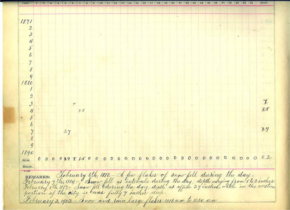
| Question #7 Has it ever snowed in San Francisco? If so, How much fell in one day? |
|
| Answer: Yes, According the the original San Francisco climate book 3.7 inches of snow was recorded in San Francisco at the U.S. Weather Bureau Office on Battery between Washington & Jackson on February 5th 1887. The Western portion of the city received up to 7 inches. | |
|
|
|
| Question #8 I have heard that snow can fall at higher temperatures than 32 degrees and have actually seen it happen as well. I have also heard that dew point plays a roll in snow appearing but not sticking in some cases. My Question is: Does the average temperature between the actual air temperature and dew point temperature control weather or not snow will stick or not? |
|
| Answer: The main factor in determining whether snow will stick to the ground and not melt is the temperature of the surface it is falling onto. The surface must be 32 degrees F or less for snow not to melt. This however does not mean that the air temperature (2 meters above the surface) has to be less than or equal to 32 degrees. The surface dew point temperature does not really play a direct role in whether snow will stick or not. The moisture and temperature vertical profile however factors into what the consistency of the snow will be when it makes it to the surface. A more moist atmosphere will generally produce larger flakes called dendritic crystals, usually consisting of the collision and coalescence of smaller flakes. A drier atmosphere generally produces smaller flakes, usually in a rod or needle shape. Larger, wet flakes generally stick more easily than dry ones, but the type and temperature of the surface material is ultimately the deciding factor. Surfaces such as asphalt or concrete have higher heat capacities than grass or vegetative surfaces and therefore are able to hold more heat from solar radiation. That is why you often hear "snow accumulation only on grassy surfaces" in cases of light snowfall amounts. |
|
|
|
|
| Question #9 What does it mean by 'Small Craft Advisory'? |
|
| Answer: The definition of "Small Craft Advisory" is when the winds are 21 to 33 knots or combined seas of 10 feet or greater are expected or occurring and are considered potentially hazardous to small craft. Note: There is no legal definition of "small craft" |
|

