Severe Thunderstorms and Possible Flooding Through This Weekend in the Central U.S.
Severe thunderstorms are forecast through this weekend along a slow moving cold front and secondary storm system that will impact areas from the southern Plains to the Great Lakes. Large hail and isolated damaging wind gusts are the main threats with these storms along with a risk for heavy to excessive rainfall which could bring flooding.
Read More >
Overview - Historic flooding at Guerneville and Monte Rio
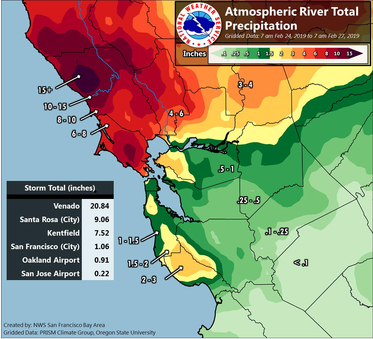
Atmospheric Rivers (ARs) are nothing new for the West Coast, especially California. ARs can bring beneficial precipitation to the Golden State by adding much needed water to reservoirs and snowpack to the Sierra. On the other hand, the tremendous amount of moisture associated with ARs can bring extremely hazardous weather, which is usually excessive rain and associated flooding. The events that unfolded on February 25 to February 27 fall in the hazardous category with a stalling AR and devastating flooding.
A low pressure began to take shape over the Eastern Pacific on February 25 as a decent moisture plume made landfall over Northern California. Over the next 24 hours the low pressure system moved eastward toward the coast and began to interact with the moisture plume. The interaction between the approaching low and moisture plume enhanced moisture transport across the Bay Area, especially Monterey Bay northward. Ultimately the moisture plume stalled across the North Bay bringing periods of moderate to heavy rain for time period of approximately 36 hours.
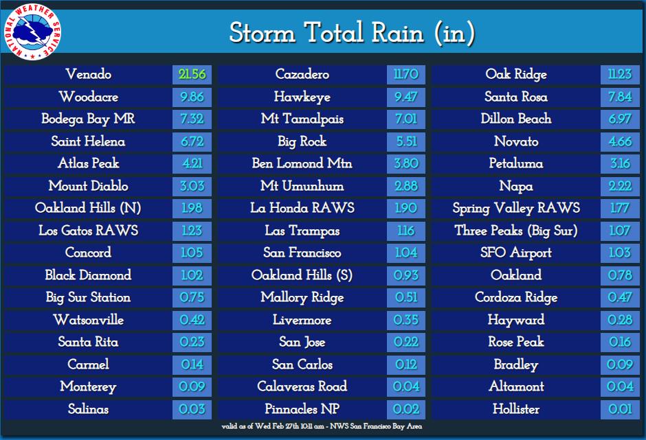
The persistent moderate to heavy rainfall led to a three day total of 10 to 15 inches of rain across the Russian River watershed. The famously wet reporting station Venado recorded 21.56 inches of rain. The impressive rainfall fell on top of already saturated soils, which severely limited water absorption into the ground. Numerous flood advisories and warnings were issued across the North Bay. Of greatest significance was the Russian River, which rose above flood stage on February 26 then continued into major flood stage the morning of February 27. The final crest near Guerneville occurred late on the evening of February 27. River levels finally dropped below flood stage at Guerneville on the morning of March 1. The towns of Guerneville and Monte Rio were impacted the most with approximately 2,000 properties having some flood damage. At one point the town of Guerneville was completely cutoff and became an “island” only accessible by boat.
In addition to the notable flooding the passing cold front brought a round of very gusty winds toppling many trees across the Bay Area. The highest wind gust recorded was 87 mph on Big Rock Ridge.
Prolific rain brought rising creeks, streams and rivers to much of the Bay Area resulting in flooding. The hardest hit area was the North Bay with catastrophic flooding at Guerneville and Monte Rio.
One of many warnings issued
Historic flood levels reached
Excessive runoff into the Pacific
Hydrograph depicting rising waters
Radar Loop of Atmospheric River Flooding Event
Storm Reports
Storm Peak Wind Gusts
Wind Advisory Issued
NWUS56 KMTR 281804
LSRMTR
PRELIMINARY LOCAL STORM REPORT...SUMMARY
NATIONAL WEATHER SERVICE SAN FRANCISCO CA
1004 AM PST THU FEB 28 2019
..TIME... ...EVENT... ...CITY LOCATION... ...LAT.LON...
..DATE... ....MAG.... ..COUNTY LOCATION..ST.. ...SOURCE....
..REMARKS..
1142 AM DEBRIS FLOW 3 NE LARKFIELD-WIKIUP 38.55N 122.72W
02/25/2019 SONOMA CA LAW ENFORCEMENT
SMALL ROCK SLIDE PARTIALLY IN SLOW LANE. NB
MARK WEST SPRINGS ROAD, JUNCTION WITH PORTER
CREEK ROAD.
0910 PM DEBRIS FLOW 6 SSW SEBASTOPOL 38.32N 122.87W
02/25/2019 SONOMA CA PUBLIC
MUD AND ROCKS BLOCKING NB LANES GERICKE RD /
VALLEY FORD RD.
1008 PM DEBRIS FLOW 10 WNW MONTE RIO 38.53N 123.18W
02/25/2019 SONOMA CA LAW ENFORCEMENT
ROCK SLIDE IN ROADWAY BLOCKING ALMOST ENTIRE
ROADWAY. FORT ROSS RD / NIESTRATH RD.
1031 PM DEBRIS FLOW 3 ENE ROHNERT PARK 38.37N 122.65W
02/25/2019 SONOMA CA LAW ENFORCEMENT
DEBRIS FLOW ON EASTBOUND CRANE CANYON HALF A
MILE FROM JUNCTION WITH PETALUMA HILL RD.
1031 PM DEBRIS FLOW 2 SE GUERNEVILLE 38.49N 122.96W
02/25/2019 SONOMA CA LAW ENFORCEMENT
MUD SLIDE AND OTHER DEBRIS IN WESTBOUND
LANE. ON WB 116 BETWEEN CANYON AND TRENTON.
1216 AM DEBRIS FLOW SAUSALITO 37.86N 122.50W
02/26/2019 MARIN CA LAW ENFORCEMENT
3-4 LANES, NEED EMERGENCY ROAD CLOSURE. US
101 N / RODEO AVE OFFRAMP.
0437 AM DEBRIS FLOW 5 WNW LAGUNITAS-FOREST 38.05N 122.76W
02/26/2019 MARIN CA LAW ENFORCEMENT
DEBRIS FLOW BLOCKING WEST BOUND LANE OF SIR
FRANCIS DRAKE BLVD NEAR PLATFORM BRIDGE RD.
0531 AM DEBRIS FLOW 4 SSE PETALUMA 38.19N 122.60W
02/26/2019 SONOMA CA LAW ENFORCEMENT
LARGE BOULDER IN SOUTHBOUND LANE OF CA-29 AT
MM 42.3.
0538 AM DEBRIS FLOW 2 NNE ROHNERT PARK 38.38N 122.69W
02/26/2019 SONOMA CA LAW ENFORCEMENT
DEBRIS FLOW PARTIALLY BLOCKING NORTHBOUND
LANE. PETALUMA HILL RD NEAR JUNCTION OF
SNYDER.
0548 AM DEBRIS FLOW 1 W DEER PARK 38.54N 122.49W
02/26/2019 NAPA CA LAW ENFORCEMENT
DEBRIS FLOW PARTIALLY BLOCKING NORTHBOUND
LANE. SILVERADO TRAIL N / GLASS MOUNTAIN RD.
0825 AM DEBRIS FLOW 1 N GRATON 38.45N 122.87W
02/26/2019 SONOMA CA LAW ENFORCEMENT
LARGE MUDSLIDE BLOCKING THE WESTBOUND LANE
NEAR SR 116 AND GREEN VALLEY ROAD.
1145 AM DEBRIS FLOW 2 SSW GRATON 38.41N 122.89W
02/26/2019 SONOMA CA LAW ENFORCEMENT
MUD BLOCKING WESTBOUND LANDS OF CHERRY RIDGE
JUNCTION GRANDVIEW.
0337 PM DEBRIS FLOW 1 SSW DEER PARK 38.52N 122.47W
02/26/2019 NAPA CA LAW ENFORCEMENT
ROCKS AND MUD ARE BLOCKING LANE ONE ON
SILVERADO TRAIL.
0340 PM DEBRIS FLOW MONTE RIO 38.46N 123.01W
02/26/2019 SONOMA CA BROADCAST MEDIA
KGO IS REPORTING A MUDSLIDE THAT HAS CLOSED
THE BOHEMIAN HIGHWAY IN BOTH DIRECTIONS,
TRAPPING PEOPLE AND POSSIBLY DAMAGING TWO
HOMES.
0546 PM DEBRIS FLOW 2 ESE HEALDSBURG 38.61N 122.84W
02/26/2019 SONOMA CA LAW ENFORCEMENT
CHP REPORTING MUD IN THE ROADWAY AT S FITCH
MOUNTAIN ROAD AND SPRING STREET WITH
VEHICLES STUCK IN THE MUD.
0604 PM DEBRIS FLOW 2 SW HEALDSBURG 38.60N 122.88W
02/26/2019 SONOMA CA LAW ENFORCEMENT
CHP REPORTING MUD, DIRT, AND/OR ROCK
BLOCKING SOUTHBOUND SIDE OF W DRY CREEK RD
AT WESTSIDE RD.
0631 PM DEBRIS FLOW 13 WNW MONTE RIO 38.52N 123.25W
02/26/2019 SONOMA CA LAW ENFORCEMENT
CALIFORNIA HIGHWAY PATROL REPORTING THAT THE
NORTHBOUND LANE OF HIGHWAY 1 IS COMPLETELY
BLOCKED WITH A MUDSLIDE AND FALLEN TREE.
0659 PM DEBRIS FLOW 1 E WINDSOR 38.55N 122.77W
02/26/2019 SONOMA CA LAW ENFORCEMENT
CALIFORNIA HIGHWAY PATROL REPORTING MUD AND
LARGE ROCKS IN NORTHBOUND LANE AT CHALK HILL
ROAD AND LESLIE ROAD.
0753 PM DEBRIS FLOW 2 NE OCCIDENTAL 38.42N 122.90W
02/26/2019 SONOMA CA LAW ENFORCEMENT
CALIFORNIA HIGHWAY PATROL REPORTING MUD,
DIRT, AND/OR ROCK BLOCKING ONE LANE OF
TRAFFIC AT GRATON ROAD AND GREEN HILL ROAD.
0759 PM DEBRIS FLOW 3 N PETALUMA 38.28N 122.62W
02/26/2019 SONOMA CA PUBLIC
CALIFORNIA HIGHWAY PATROL VIA PUBLIC REPORT
OF MUD/DIRT/ROCK COVERING THE SOUTHBOUND
LANE OF SONOMA MOUNTAIN ROAD, ABOUT A
QUARTER OF THE WAY UP FROM ADOBE ROAD.
0808 PM DEBRIS FLOW 1 NE MONTE RIO 38.48N 123.00W
02/26/2019 SONOMA CA LAW ENFORCEMENT
CALIFORNIA HIGHWAY PATROL REPORTING TREES
AND MUD BLOCKING ROADWAY AT HIGHWAY 116 AND
REDWOOD DRIVE.
0817 PM DEBRIS FLOW 2 W EL VERANO 38.29N 122.53W
02/26/2019 SONOMA CA LAW ENFORCEMENT
CALIFORNIA HIGHWAY PATROL REPORTING
MUD/DIRT/ROCK COMPLETELY BLOCKING ONE LANE
ALONG GROVE STREET AND WHITE ALDER.
0851 PM DEBRIS FLOW 3 NW CLOVERDALE 38.84N 123.06W
02/26/2019 SONOMA CA LAW ENFORCEMENT
CALIFORNIA HIGHWAY PATROL REPORTING MUD
SLIDE BLOCKING NORTH AND SOUTHBOUND LANES OF
HIGHWAY 128.
0905 PM DEBRIS FLOW 16 WNW MONTE RIO 38.55N 123.30W
02/26/2019 SONOMA CA LAW ENFORCEMENT
CALIFORNIA HIGHWAY PATROL REPORTING
NORTHBOUND LANE AT HIGHWAY 1 AND STILLWATER
COVE PARK COMPLETELY BLOCKED DUE TO
MUD/DIRT/ROCK SLIDE.
0957 PM DEBRIS FLOW 6 WNW GUERNEVILLE 38.54N 123.09W
02/26/2019 SONOMA CA LAW ENFORCEMENT
CALIFORNIA HIGHWAY PATROL REPORTING 8+
PEOPLE STUCK BETWEEN FORT ROSS AND MYERS
GRADE ROAD FROM 2 MUDSLIDES. BOTH DIRECTIONS
OF ROAD BLOCKED. LAT/LON IN LSR FROM CHP
REPORT.
1045 PM DEBRIS FLOW 1 NE GLEN ELLEN 38.37N 122.52W
02/26/2019 SONOMA CA LAW ENFORCEMENT
MUD/DIRT/ROCK SLIDE REPORTED AT WARM SPRINGS
RD AND ARNOLD DR.
1200 AM DEBRIS FLOW 1 NNW OCCIDENTAL 38.41N 122.95W
02/27/2019 SONOMA CA LAW ENFORCEMENT
MUDSLIDE AND TREES BLOCKING ROADWAY AT
BOHEMIAN HWY AND SCOUTS CAMP RD.
1226 AM DEBRIS FLOW 13 WNW MONTE RIO 38.52N 123.25W
02/27/2019 SONOMA CA LAW ENFORCEMENT
ROCK AND MUDSLIDE BLOCKING NB LANE OF SR 1
AT FORT ROSS RD.
1239 AM DEBRIS FLOW 1 WSW SANTA VENETIA 38.00N 122.52W
02/27/2019 MARIN CA LAW ENFORCEMENT
MUD SLIDE BLOCKING 2 LANES NEAR SAN PEDRO
RD.
0354 AM DEBRIS FLOW 2 NW CLOVERDALE 38.83N 123.04W
02/27/2019 SONOMA CA LAW ENFORCEMENT
3 FEET OF MUD AND ROCKS BLOCKING ALL LANES
OF THE ROAD AT SR-128 AT HOGWARTS WAY. ROAD
CLOSED FOR MANY HOURS.
0438 AM DEBRIS FLOW 10 ENE YOUNTVILLE 38.45N 122.20W
02/27/2019 NAPA CA LAW ENFORCEMENT
DEBRIS FLOW BLOCKING ALMOST ENTIRE ROADWAY.
SR-128 AT STEELE CANYON RD.
0514 AM DEBRIS FLOW 4 SE SONOMA 38.25N 122.39W
02/27/2019 SONOMA CA LAW ENFORCEMENT
DIRT SLIDE IN THE ROADWAY. NORTHBOUND NAPA
NEAR JUNCTION WITH SR-121.
1157 AM FLOOD 9 SE BODEGA BAY 38.25N 122.90W
02/25/2019 MARIN CA LAW ENFORCEMENT
2 FEET OF WATER IN ROADWAY, VEHICLE STALLED.
SHORELINE HIGHWAY INTERSECTION WITH BAY
ROAD.
0830 PM FLOOD 2 NE FORESTVILLE 38.51N 122.86W
02/25/2019 SONOMA CA DEPT OF HIGHWAYS
DETAIL INFORMATION 9:31 PM 12 [18]
[NOTIFICATION] [CHP]-[17] PER SONSO ETA UP
TO AN HOUR 9:31 PM 11 [17] PER SONSO ETA UP
TO AN HOUR 9:27 PM 10 [15] [NOTIFICATION]
[CHP]-SON SO / NO ETA FRM CORDS - WILL ADV
WHEN THEY GET 1 9:26 PM 9 [14] 1039 SONSO //
WLL CB WITH ETA 9:25 PM 8 [13] REQ UPDATED
ETA FOR CORDS 8:30 PM 7 [11] 1039 CORDS 8:28
PM 6 [9] 17-32B / ENTIRE RD FLOODED 8:28 PM
5 [8] 17-32B ENTIRE ROAD FLOODED 8:27 PM 4
[7] B17-032B NB LN FLOODED RESPOND WITH
SIGNS 8:21 PM 3 [6] 1039 SONS SO CORDS FOR
SIGNS 8:20 PM 2 [4] 1039 SON SO FOR CORDS
FOR SIGN 8:06 PM 1 [1] BOTH EB AND WB LNS
FLOODED.
0850 PM FLOOD 1 WNW ROHNERT PARK 38.35N 122.72W
02/25/2019 SONOMA CA PUBLIC
DETAIL INFORMATION 8:50 PM 6 [9] LOG 2688 NB
101 AT WINDSOR RIVER #1 8:44 PM 5 [8] LOG
2609 MILL STATION AT FERGUSON NB AND SB
LANES FLOODED SIGNS ON SB 1039 CORDS FOR NB
LANES 8:43 PM 4 [7] LOG 2517 EASTSIDE JWO
WINDSOR RIVER 2-3 INCHES FLOODING 1039 CORDS
8:30 PM 3 [6] LOG 2584 EB EASTSIDE 1/2 MILE
JEO TRENTON HEALDSBURG 1039 CORD ENTIRE RD
FLOODED 7:08 PM 2 [4] 17-FLD GG02362 4080
OLD REDWOOD HWY X EDWARDS RANCH / 6 INCHES
IN NB LN / 1039 CORDS 5:52 PM 1 [3] 17-FLD
GG02226 GREEN VALLEY AT SULLIVAN / CORDS
ENRT FOR FULL CLOSURE.
0901 PM FLOOD 5 SSE OCCIDENTAL 38.32N 122.90W
02/25/2019 SONOMA CA PUBLIC
DETAIL INFORMATION 9:06 PM 4 [5] HAD JUST
CALLED FOR TOW 9:06 PM 3 [4] RP CHECKED ON
OCUP AND NEG INJURY 9:05 PM 2 [3] VEH THAT
IS STUCK IS RED VW PASSAT OR SIMILAR 9:05 PM
1 [1] ONE VEH STUCK IN FLOOD AND 2ND VEH
WENT THROUGH.
1032 PM FLOOD 3 ESE TEMELEC 38.24N 122.45W
02/25/2019 SONOMA CA LAW ENFORCEMENT
SR 121 AT SCHELLVILLE FIRE CLOSED.
1206 AM FLOOD CORTE MADERA 37.92N 122.51W
02/26/2019 MARIN CA LAW ENFORCEMENT
ROADWAY FLOODING NORTHBOUND 101 AT LUCKY.
1210 AM FLOOD 1 SE SEBASTOPOL 38.38N 122.81W
02/26/2019 SONOMA CA LAW ENFORCEMENT
FLOODING IN WESTBOUND LANE OF 116 AT SPARKES
RD.
1226 AM FLOOD 2 W ROHNERT PARK 38.35N 122.74W
02/26/2019 SONOMA CA LAW ENFORCEMENT
VEHICLES STUCK IN FLOODING. ROHNERT PARK
EXPRESSWAY W / STONY POINT ROAD.
1259 AM FLOOD 1 E LAGUNITAS-FOREST KN 38.01N 122.66W
02/26/2019 MARIN CA LAW ENFORCEMENT
WATER ACROSS ROADWAY IN THE AREA, ALSO TREE
DOWN BLOCKING ENTIRE ROADWAY. NICASIO VALLEY
ROAD / SAN GERONIMO VALLEY DRIVE.
0107 AM FLOOD 4 WNW PETALUMA 38.26N 122.70W
02/26/2019 SONOMA CA LAW ENFORCEMENT
ROADWAY FLOODED, ROAD CLOSED. INTERSECTION
OF SKILLMAN LANE AND LIBERTY ROAD.
0132 AM FLOOD 1 E TEMELEC 38.25N 122.48W
02/26/2019 SONOMA CA LAW ENFORCEMENT
ROADWAY FLOODING, SOUTHBOUND LANE OF ARNOLD
DRIVE NEAR SR 116.
0238 AM FLOOD 1 ENE LARKSPUR 37.94N 122.51W
02/26/2019 MARIN CA LAW ENFORCEMENT
APPROXIMATELY 6 INCHES OF WATER ACROSS ALL
LANES. NORTHBOUND 101 AT CORTE MADERA.
0320 AM FLOOD 9 SE BODEGA BAY 38.24N 122.91W
02/26/2019 MARIN CA LAW ENFORCEMENT
VEHICLE STUCK IN WATER FLOODING THE LANES.
SOUTHBOUND CA-1 & TOMALES ROAD.
0435 AM FLOOD 2 SSE PLEASANT HILL 37.93N 122.06W
02/26/2019 CONTRA COSTA CA LAW ENFORCEMENT
RIGHT HAND SIDE AND SLOW LANE WATER ON
ROADWAY. SOUTHBOUND 680 JUNCTION WITH TREAT
BLVD.
0453 AM FLOOD 4 SSE PETALUMA 38.18N 122.60W
02/26/2019 MARIN CA LAW ENFORCEMENT
6-8 INCHES OF WATER ACROSS ROADWAY. AT
INTERSECTION OF SAN ANTONIO RD AND SAN
ANTONIO SPUR.
0540 AM FLOOD 3 E FORESTVILLE 38.49N 122.83W
02/26/2019 SONOMA CA PUBLIC
FLOODING AT SLUSSER ROAD NEAR MARK WEST
CREEK IN SANTA ROSA.
0726 AM FLOOD 4 ESE INVERNESS 38.06N 122.77W
02/26/2019 MARIN CA DEPT OF HIGHWAYS
PLATFORM BRIDGE ROAD CLOSED DUE TO FLOODING.
0752 AM FLOOD 3 NE LARKFIELD-WIKIUP 38.55N 122.72W
02/26/2019 SONOMA CA LAW ENFORCEMENT
ROAD FLOODED.
0757 AM FLOOD GRATON 38.44N 122.87W
02/26/2019 SONOMA CA BROADCAST MEDIA
GRATON RD FLOODED FROM ATASCADERO CREEK.
0803 AM FLOOD 4 SSE SONOMA 38.24N 122.42W
02/26/2019 SONOMA CA LAW ENFORCEMENT
FLOODING - POSSIBLE LEVEE BREACH.
0821 AM FLOOD 2 N SEBASTOPOL 38.43N 122.83W
02/26/2019 SONOMA CA LAW ENFORCEMENT
SANFORD ROAD AND OCCIDENTAL ROAD ARE
FLOODED. VEHICLES ARE STILL TRYING TO DRIVE
THROUGH.
0823 AM FLOOD 3 E FORESTVILLE 38.49N 122.83W
02/26/2019 SONOMA CA PUBLIC
SLUSSER ROAD COMPLETELY FLOODED.
0838 AM FLOOD 2 SE INVERNESS 38.06N 122.81W
02/26/2019 MARIN CA NWS EMPLOYEE
SUV WASHED OFF THE SIDE OF THE FLOODED ROAD
WAY AT THE ENTRANCE OF POINT REYES PARK.
0858 AM FLOOD COTATI 38.33N 122.71W
02/26/2019 SONOMA CA LAW ENFORCEMENT
ROADWAY FLOODING AT SR 116 NEAR THE
JUNCTIONS OF REDWOOD AND RIDGECREST.
0901 AM FLOOD 1 NW INVERNESS 38.10N 122.85W
02/26/2019 MARIN CA COUNTY OFFICIAL
ROADS BETWEEN INVERNESS AND POINT REYES ARE
CLOSED. RESIDENTS OF INVERNESS SHOULD STAY
OFF ROADS UNTIL WATERS SUBSIDE AND CREWS CAN
REOPEN ROADWAYS.
1030 AM FLOOD ELDRIDGE 38.34N 122.51W
02/26/2019 SONOMA CA LAW ENFORCEMENT
MADRONE ROAD NEAR HWY 12 FLOODED.
1056 AM FLOOD 3 SSE SONOMA 38.25N 122.44W
02/26/2019 SONOMA CA COUNTY OFFICIAL
8TH ST E IS NOW CLOSED BETWEEN SCHELLVILLE
RD AND HWY 121/12 FLOODING.
1233 PM FLOOD 5 NNW GLEN ELLEN 38.43N 122.56W
02/26/2019 SONOMA CA LAW ENFORCEMENT
WESTBOUND SR 12 AT HOFF ROAD ARE FLOODED.
1244 PM FLOOD 1 S SOUTH SANTA ROSA 38.39N 122.72W
02/26/2019 SONOMA CA LAW ENFORCEMENT
EASTBOUND TODD TO NORTHBOUND STANDISH - ALL
THE LANES ARE FLOODED.
0348 PM FLOOD 3 SSW SOUTH SANTA ROSA 38.37N 122.74W
02/26/2019 SONOMA CA LAW ENFORCEMENT
CHP REPORTED ROADWAY FLOODING AT MILLBRAE
AVE AND STONY POINT RD. VEHICLES DRIVING
THROUGH FLOODED ROAD AND WATER IS RISING.
0400 PM FLOOD 1 SW GUERNEVILLE 38.50N 122.99W
02/26/2019 SONOMA CA LAW ENFORCEMENT
THE RUSSIAN RIVER AT GUERNEVILLE HIT FLOOD
STAGE (32FT) AT APPROXIMATELY 1600 HRS ON
FEBRUARY 26, 2019. GAUGE CESTED AT 45.38
FEET 2230 PM FEBRUARY 27, 2019. LOCAL LAW
ENFORCEMENT INDICATED THE TOWN OF
GUERNEVILLE BECAME AN ISLAND AND WAS ONLY
ACCESSIBLE BY BOAT OR HELICOPTER. MEDIA
REPORTED APPROXIMATELY 4,000 STRUCTURES WERE
IMPACTED BY FLOOD WATERS.
0400 PM FLOOD MONTE RIO 38.46N 123.01W
02/26/2019 SONOMA CA LAW ENFORCEMENT
THE RUSSIAN RIVER AT GUERNEVILLE HIT FLOOD
STAGE (32FT) AT APPROXIMATELY 1600 HRS ON
FEBRUARY 26, 2019. GAUGE CESTED AT 45.38
FEET 2230 PM FEBRUARY 27, 2019. LOCAL LAW
ENFORCEMENT INDICATED THE TOWN OF MONTE RIO
BECAME AN ISLAND AND WAS ONLY ACCESSIBLE BY
BOAT OR HELICOPTER. MEDIA REPORTED
APPROXIMATELY 4,000 STRUCTURES (MONTE
RIO/GUERNEVILLE) WERE IMPACTED BY FLOOD
WATERS.
0542 PM FLOOD 3 SSW LARKFIELD-WIKIUP 38.47N 122.77W
02/26/2019 SONOMA CA LAW ENFORCEMENT
CHP REPORTING SIGNIFICANT AMOUNT OF FLOODING
IN THE ROADWAY AT PINER ROAD AND FULTON ROAD
IN SANTA ROSA.
0640 PM FLOOD 2 WNW PETALUMA 38.25N 122.66W
02/26/2019 SONOMA CA PUBLIC
CALIFORNIA HIGHWAY PATROL REPORTING ROADWAY
FLOODING AT MAGNOLIA AVE AND GOSSAGE AVE IN
SANTA ROSA. OVER 1 FT OF WATER IN THE
SOUTHBOUND MAGNOLIA AVE LANE.
0644 PM FLOOD 3 NNE HEALDSBURG 38.66N 122.84W
02/26/2019 SONOMA CA LAW ENFORCEMENT
CALIFORNIA HIGHWAY PATROL REPORTING A
VEHICLE STUCK IN HIGH SPOT BETWEEN FLOODED
AREAS ON ALEXANDER VALLEY ROAD.
0650 PM FLOOD 2 W MONTE RIO 38.47N 123.05W
02/26/2019 SONOMA CA LAW ENFORCEMENT
CALIFORNIA HIGHWAY PATROL REPORTING ROADWAY
FLOODING AT HIGHWAY 116 AND AUSTIN CREEK
ROAD.
0657 PM FLOOD 1 NE GRATON 38.45N 122.85W
02/26/2019 SONOMA CA LAW ENFORCEMENT
CALIFORNIA HIGHWAY PATROL REPORTING WATER
ACROSS ALL LANES NEAR FREI LANE AND
GUERNEVILLE ROAD.
0659 PM FLOOD 9 SE BODEGA BAY 38.24N 122.91W
02/26/2019 MARIN CA LAW ENFORCEMENT
CHP REPORTING THAT THE MARIN FIRE DEPARTMENT
IS RETRIEVING A DRIVER STUCK IN THE WATER AT
HIGHWAY 1 AND TOMALES ROAD.
0729 PM FLOOD 3 SE INVERNESS 38.05N 122.80W
02/26/2019 MARIN CA LAW ENFORCEMENT
CALIFORNIA HIGHWAY PATROL REPORTING ROADWAY
FLOODING ALONG HIGHWAY 1 BETWEEN OLEMA AND
POINT REYES STATION.
0740 PM FLOOD 1 SSW LARKFIELD-WIKIUP 38.50N 122.76W
02/26/2019 SONOMA CA LAW ENFORCEMENT
CALIFORNIA HIGHWAY PATROL REPORTING MORE
THAN A FOOT OF WATER COVERING BOTH LANES OF
TRAFFIC ON BARNES ROAD NEAR RIVER ROAD.
0802 PM FLOOD 2 NNW CALISTOGA 38.61N 122.60W
02/26/2019 NAPA CA LAW ENFORCEMENT
CALIFORNIA HIGHWAY PATROL REPORTING PARTIAL
ROADWAY FLOODED AT HIGHWAY 29 AND TUBBS
LANE.
0806 PM FLOOD 3 W PETALUMA 38.25N 122.68W
02/26/2019 SONOMA CA LAW ENFORCEMENT
CALIFORNIA HIGHWAY PATROL REPORTING ROADWAY
FLOODING ALONG MAGNOLIA ROAD BETWEEN HORN
AVENUE AND THOMPSON LANE.
0819 PM FLOOD 1 S FORESTVILLE 38.47N 122.89W
02/26/2019 SONOMA CA LAW ENFORCEMENT
CALIFORNIA HIGHWAY PATROL REPORTING ROADWAY
FLOODING AT HIGHWAY 116 AND PACKING HOUSE
ROAD. ONE VEHICLE STUCK IN WATER.
0831 PM FLOOD 2 SSE WINDSOR 38.52N 122.79W
02/26/2019 SONOMA CA LAW ENFORCEMENT
CALIFORNIA HIGHWAY PATROL REPORTING 2 OF THE
3 LANES FLOODED ALONG NORTHBOUND 101 ON THE
SHILOH ROAD OFF RAMP.
0846 PM FLOOD 1 E TEMELEC 38.25N 122.48W
02/26/2019 SONOMA CA LAW ENFORCEMENT
CALIFORNIA HIGHWAY PATROL REPORTING STANDING
WATER IN LANE AT HIGHWAY 116 AND ARNOLD
ROAD.
0907 PM FLOOD 6 SSE OCCIDENTAL 38.32N 122.90W
02/26/2019 SONOMA CA LAW ENFORCEMENT
CALIFORNIA HIGHWAY PATROL REPORTING DRIVER
STUCK IN FLOODED ROADWAY AT HIGHWAY 1 AND
VALLEY FORD ROAD.
0909 PM FLOOD 2 WNW COTATI 38.34N 122.74W
02/26/2019 SONOMA CA LAW ENFORCEMENT
CALIFORNIA HIGHWAY PATROL REPORTING ROADWAY
FLOODING AT HIGHWAY 116 AND STONY POINT
ROAD.
0917 PM FLOOD 3 WNW ROSELAND 38.44N 122.78W
02/26/2019 SONOMA CA LAW ENFORCEMENT
CALIFORNIA HIGHWAY PATROL REPORTING ROADWAY
FLOODING AT HALL ROAD AND PARK ROYAL AVENUE.
0948 PM FLOOD 2 WNW MONTE RIO 38.48N 123.05W
02/26/2019 SONOMA CA LAW ENFORCEMENT
CALIFORNIA HIGHWAY PATROL REPORTING VEHICLE
STUCK IN FLOODED ROADWAY AT CAZADERO HIGHWAY
AND MAGIC MOUNTAIN ROAD. WATER IS COMING
INTO THE VEHICLE.
1025 PM FLOOD 1 SW HEALDSBURG 38.61N 122.88W
02/26/2019 SONOMA CA PUBLIC
PUBLIC REPORT VIA CALIFORNIA HIGHWAY PATROL
OF ROADWAY FLOODING ON SOUTHBOUND HIGHWAY
101 OFF RAMP AT MILL STREET.
1025 PM FLOOD 2 SE TEMELEC 38.24N 122.48W
02/26/2019 SONOMA CA PUBLIC
CALIFORNIA HIGHWAY PATROL REPORTING BOTH
NORTH AND SOUTHBOUND LANES FLOODED AT
BONNESS ROAD AND KORNECK ROAD.
1027 PM FLOOD 1 S HEALDSBURG 38.60N 122.86W
02/26/2019 SONOMA CA LAW ENFORCEMENT
CALIFORNIA HIGHWAY PATROL REPORTING ROADWAY
FLOODING ON THE 101 OFF RAMP AT HEALDSBURG
AVENUE.
1035 PM FLOOD 2 NNW ROHNERT PARK 38.37N 122.71W
02/26/2019 SONOMA CA PUBLIC
PUBLIC REPORT VIA CALIFORNIA HIGHWAY PATROL
OF ROADWAY FLOODING AT SANTA ROSA AVE AND
ROBERTS LAKE ROAD.
1058 PM FLOOD 1 WSW DEER PARK 38.53N 122.48W
02/26/2019 NAPA CA LAW ENFORCEMENT
6 INCHES OF WATER AT DEER PARK JWO SILVERADO
TRAIL.
1157 AM FLOOD 9 SE BODEGA BAY 38.25N 122.90W
02/25/2019 MARIN CA LAW ENFORCEMENT
2 FEET OF WATER IN ROADWAY, VEHICLE STALLED.
SHORELINE HIGHWAY INTERSECTION WITH BAY
ROAD.
0830 PM FLOOD 2 NE FORESTVILLE 38.51N 122.86W
02/25/2019 SONOMA CA DEPT OF HIGHWAYS
DETAIL INFORMATION 9:31 PM 12 [18]
[NOTIFICATION] [CHP]-[17] PER SONSO ETA UP
TO AN HOUR 9:31 PM 11 [17] PER SONSO ETA UP
TO AN HOUR 9:27 PM 10 [15] [NOTIFICATION]
[CHP]-SON SO / NO ETA FRM CORDS - WILL ADV
WHEN THEY GET 1 9:26 PM 9 [14] 1039 SONSO //
WLL CB WITH ETA 9:25 PM 8 [13] REQ UPDATED
ETA FOR CORDS 8:30 PM 7 [11] 1039 CORDS 8:28
PM 6 [9] 17-32B / ENTIRE RD FLOODED 8:28 PM
5 [8] 17-32B ENTIRE ROAD FLOODED 8:27 PM 4
[7] B17-032B NB LN FLOODED RESPOND WITH
SIGNS 8:21 PM 3 [6] 1039 SONS SO CORDS FOR
SIGNS 8:20 PM 2 [4] 1039 SON SO FOR CORDS
FOR SIGN 8:06 PM 1 [1] BOTH EB AND WB LNS
FLOODED.
0850 PM FLOOD 1 WNW ROHNERT PARK 38.35N 122.72W
02/25/2019 SONOMA CA PUBLIC
DETAIL INFORMATION 8:50 PM 6 [9] LOG 2688 NB
101 AT WINDSOR RIVER #1 8:44 PM 5 [8] LOG
2609 MILL STATION AT FERGUSON NB AND SB
LANES FLOODED SIGNS ON SB 1039 CORDS FOR NB
LANES 8:43 PM 4 [7] LOG 2517 EASTSIDE JWO
WINDSOR RIVER 2-3 INCHES FLOODING 1039 CORDS
8:30 PM 3 [6] LOG 2584 EB EASTSIDE 1/2 MILE
JEO TRENTON HEALDSBURG 1039 CORD ENTIRE RD
FLOODED 7:08 PM 2 [4] 17-FLD GG02362 4080
OLD REDWOOD HWY X EDWARDS RANCH / 6 INCHES
IN NB LN / 1039 CORDS 5:52 PM 1 [3] 17-FLD
GG02226 GREEN VALLEY AT SULLIVAN / CORDS
ENRT FOR FULL CLOSURE.
0901 PM FLOOD 5 SSE OCCIDENTAL 38.32N 122.90W
02/25/2019 SONOMA CA PUBLIC
DETAIL INFORMATION 9:06 PM 4 [5] HAD JUST
CALLED FOR TOW 9:06 PM 3 [4] RP CHECKED ON
OCUP AND NEG INJURY 9:05 PM 2 [3] VEH THAT
IS STUCK IS RED VW PASSAT OR SIMILAR 9:05 PM
1 [1] ONE VEH STUCK IN FLOOD AND 2ND VEH
WENT THROUGH.
1032 PM FLOOD 3 ESE TEMELEC 38.24N 122.45W
02/25/2019 SONOMA CA LAW ENFORCEMENT
SR 121 AT SCHELLVILLE FIRE CLOSED.
1206 AM FLOOD CORTE MADERA 37.92N 122.51W
02/26/2019 MARIN CA LAW ENFORCEMENT
ROADWAY FLOODING NORTHBOUND 101 AT LUCKY.
1210 AM FLOOD 1 SE SEBASTOPOL 38.38N 122.81W
02/26/2019 SONOMA CA LAW ENFORCEMENT
FLOODING IN WESTBOUND LANE OF 116 AT SPARKES
RD.
1226 AM FLOOD 2 W ROHNERT PARK 38.35N 122.74W
02/26/2019 SONOMA CA LAW ENFORCEMENT
VEHICLES STUCK IN FLOODING. ROHNERT PARK
EXPRESSWAY W / STONY POINT ROAD.
1259 AM FLOOD 1 E LAGUNITAS-FOREST KN 38.01N 122.66W
02/26/2019 MARIN CA LAW ENFORCEMENT
WATER ACROSS ROADWAY IN THE AREA, ALSO TREE
DOWN BLOCKING ENTIRE ROADWAY. NICASIO VALLEY
ROAD / SAN GERONIMO VALLEY DRIVE.
0107 AM FLOOD 4 WNW PETALUMA 38.26N 122.70W
02/26/2019 SONOMA CA LAW ENFORCEMENT
ROADWAY FLOODED, ROAD CLOSED. INTERSECTION
OF SKILLMAN LANE AND LIBERTY ROAD.
0132 AM FLOOD 1 E TEMELEC 38.25N 122.48W
02/26/2019 SONOMA CA LAW ENFORCEMENT
ROADWAY FLOODING, SOUTHBOUND LANE OF ARNOLD
DRIVE NEAR SR 116.
0238 AM FLOOD 1 ENE LARKSPUR 37.94N 122.51W
02/26/2019 MARIN CA LAW ENFORCEMENT
APPROXIMATELY 6 INCHES OF WATER ACROSS ALL
LANES. NORTHBOUND 101 AT CORTE MADERA.
0320 AM FLOOD 9 SE BODEGA BAY 38.24N 122.91W
02/26/2019 MARIN CA LAW ENFORCEMENT
VEHICLE STUCK IN WATER FLOODING THE LANES.
SOUTHBOUND CA-1 & TOMALES ROAD.
0435 AM FLOOD 2 SSE PLEASANT HILL 37.93N 122.06W
02/26/2019 CONTRA COSTA CA LAW ENFORCEMENT
RIGHT HAND SIDE AND SLOW LANE WATER ON
ROADWAY. SOUTHBOUND 680 JUNCTION WITH TREAT
BLVD.
0453 AM FLOOD 4 SSE PETALUMA 38.18N 122.60W
02/26/2019 MARIN CA LAW ENFORCEMENT
6-8 INCHES OF WATER ACROSS ROADWAY. AT
INTERSECTION OF SAN ANTONIO RD AND SAN
ANTONIO SPUR.
0540 AM FLOOD 3 E FORESTVILLE 38.49N 122.83W
02/26/2019 SONOMA CA PUBLIC
FLOODING AT SLUSSER ROAD NEAR MARK WEST
CREEK IN SANTA ROSA.
0726 AM FLOOD 4 ESE INVERNESS 38.06N 122.77W
02/26/2019 MARIN CA DEPT OF HIGHWAYS
PLATFORM BRIDGE ROAD CLOSED DUE TO FLOODING.
0752 AM FLOOD 3 NE LARKFIELD-WIKIUP 38.55N 122.72W
02/26/2019 SONOMA CA LAW ENFORCEMENT
ROAD FLOODED.
0757 AM FLOOD GRATON 38.44N 122.87W
02/26/2019 SONOMA CA BROADCAST MEDIA
GRATON RD FLOODED FROM ATASCADERO CREEK.
0803 AM FLOOD 4 SSE SONOMA 38.24N 122.42W
02/26/2019 SONOMA CA LAW ENFORCEMENT
FLOODING - POSSIBLE LEVEE BREACH.
0821 AM FLOOD 2 N SEBASTOPOL 38.43N 122.83W
02/26/2019 SONOMA CA LAW ENFORCEMENT
SANFORD ROAD AND OCCIDENTAL ROAD ARE
FLOODED. VEHICLES ARE STILL TRYING TO DRIVE
THROUGH.
0823 AM FLOOD 3 E FORESTVILLE 38.49N 122.83W
02/26/2019 SONOMA CA PUBLIC
SLUSSER ROAD COMPLETELY FLOODED.
0838 AM FLOOD 2 SE INVERNESS 38.06N 122.81W
02/26/2019 MARIN CA NWS EMPLOYEE
SUV WASHED OFF THE SIDE OF THE FLOODED ROAD
WAY AT THE ENTRANCE OF POINT REYES PARK.
0858 AM FLOOD COTATI 38.33N 122.71W
02/26/2019 SONOMA CA LAW ENFORCEMENT
ROADWAY FLOODING AT SR 116 NEAR THE
JUNCTIONS OF REDWOOD AND RIDGECREST.
0901 AM FLOOD 1 NW INVERNESS 38.10N 122.85W
02/26/2019 MARIN CA COUNTY OFFICIAL
ROADS BETWEEN INVERNESS AND POINT REYES ARE
CLOSED. RESIDENTS OF INVERNESS SHOULD STAY
OFF ROADS UNTIL WATERS SUBSIDE AND CREWS CAN
REOPEN ROADWAYS.
1030 AM FLOOD ELDRIDGE 38.34N 122.51W
02/26/2019 SONOMA CA LAW ENFORCEMENT
MADRONE ROAD NEAR HWY 12 FLOODED.
1056 AM FLOOD 3 SSE SONOMA 38.25N 122.44W
02/26/2019 SONOMA CA COUNTY OFFICIAL
8TH ST E IS NOW CLOSED BETWEEN SCHELLVILLE
RD AND HWY 121/12 FLOODING.
1233 PM FLOOD 5 NNW GLEN ELLEN 38.43N 122.56W
02/26/2019 SONOMA CA LAW ENFORCEMENT
WESTBOUND SR 12 AT HOFF ROAD ARE FLOODED.
1244 PM FLOOD 1 S SOUTH SANTA ROSA 38.39N 122.72W
02/26/2019 SONOMA CA LAW ENFORCEMENT
EASTBOUND TODD TO NORTHBOUND STANDISH - ALL
THE LANES ARE FLOODED.
0348 PM FLOOD 3 SSW SOUTH SANTA ROSA 38.37N 122.74W
02/26/2019 SONOMA CA LAW ENFORCEMENT
CHP REPORTED ROADWAY FLOODING AT MILLBRAE
AVE AND STONY POINT RD. VEHICLES DRIVING
THROUGH FLOODED ROAD AND WATER IS RISING.
0400 PM FLOOD MONTE RIO 38.46N 123.01W
02/26/2019 SONOMA CA LAW ENFORCEMENT
THE RUSSIAN RIVER AT GUERNEVILLE HIT FLOOD
STAGE (32FT) AT APPROXIMATELY 1600 HRS ON
FEBRUARY 26, 2019. GAUGE CESTED AT 45.38
FEET 2230 PM FEBRUARY 27, 2019. LOCAL LAW
ENFORCEMENT INDICATED THE TOWN OF MONTE RIO
BECAME AN ISLAND AND WAS ONLY ACCESSIBLE BY
BOAT OR HELICOPTER. MEDIA REPORTED
APPROXIMATELY 4,000 STRUCTURES (MONTE
RIO/GUERNEVILLE) WERE IMPACTED BY FLOOD
WATERS.
0400 PM FLOOD 1 SW GUERNEVILLE 38.50N 122.99W
02/26/2019 SONOMA CA LAW ENFORCEMENT
THE RUSSIAN RIVER AT GUERNEVILLE HIT FLOOD
STAGE (32FT) AT APPROXIMATELY 1600 HRS ON
FEBRUARY 26, 2019. GAUGE CESTED AT 45.38
FEET 2230 PM FEBRUARY 27, 2019. LOCAL LAW
ENFORCEMENT INDICATED THE TOWN OF
GUERNEVILLE BECAME AN ISLAND AND WAS ONLY
ACCESSIBLE BY BOAT OR HELICOPTER. MEDIA
REPORTED APPROXIMATELY 4,000 STRUCTURES WERE
IMPACTED BY FLOOD WATERS.
0542 PM FLOOD 3 SSW LARKFIELD-WIKIUP 38.47N 122.77W
02/26/2019 SONOMA CA LAW ENFORCEMENT
CHP REPORTING SIGNIFICANT AMOUNT OF FLOODING
IN THE ROADWAY AT PINER ROAD AND FULTON ROAD
IN SANTA ROSA.
0640 PM FLOOD 2 WNW PETALUMA 38.25N 122.66W
02/26/2019 SONOMA CA PUBLIC
CALIFORNIA HIGHWAY PATROL REPORTING ROADWAY
FLOODING AT MAGNOLIA AVE AND GOSSAGE AVE IN
SANTA ROSA. OVER 1 FT OF WATER IN THE
SOUTHBOUND MAGNOLIA AVE LANE.
0644 PM FLOOD 3 NNE HEALDSBURG 38.66N 122.84W
02/26/2019 SONOMA CA LAW ENFORCEMENT
CALIFORNIA HIGHWAY PATROL REPORTING A
VEHICLE STUCK IN HIGH SPOT BETWEEN FLOODED
AREAS ON ALEXANDER VALLEY ROAD.
0650 PM FLOOD 2 W MONTE RIO 38.47N 123.05W
02/26/2019 SONOMA CA LAW ENFORCEMENT
CALIFORNIA HIGHWAY PATROL REPORTING ROADWAY
FLOODING AT HIGHWAY 116 AND AUSTIN CREEK
ROAD.
0657 PM FLOOD 1 NE GRATON 38.45N 122.85W
02/26/2019 SONOMA CA LAW ENFORCEMENT
CALIFORNIA HIGHWAY PATROL REPORTING WATER
ACROSS ALL LANES NEAR FREI LANE AND
GUERNEVILLE ROAD.
0659 PM FLOOD 9 SE BODEGA BAY 38.24N 122.91W
02/26/2019 MARIN CA LAW ENFORCEMENT
CHP REPORTING THAT THE MARIN FIRE DEPARTMENT
IS RETRIEVING A DRIVER STUCK IN THE WATER AT
HIGHWAY 1 AND TOMALES ROAD.
0729 PM FLOOD 3 SE INVERNESS 38.05N 122.80W
02/26/2019 MARIN CA LAW ENFORCEMENT
CALIFORNIA HIGHWAY PATROL REPORTING ROADWAY
FLOODING ALONG HIGHWAY 1 BETWEEN OLEMA AND
POINT REYES STATION.
0740 PM FLOOD 1 SSW LARKFIELD-WIKIUP 38.50N 122.76W
02/26/2019 SONOMA CA LAW ENFORCEMENT
CALIFORNIA HIGHWAY PATROL REPORTING MORE
THAN A FOOT OF WATER COVERING BOTH LANES OF
TRAFFIC ON BARNES ROAD NEAR RIVER ROAD.
0802 PM FLOOD 2 NNW CALISTOGA 38.61N 122.60W
02/26/2019 NAPA CA LAW ENFORCEMENT
CALIFORNIA HIGHWAY PATROL REPORTING PARTIAL
ROADWAY FLOODED AT HIGHWAY 29 AND TUBBS
LANE.
0806 PM FLOOD 3 W PETALUMA 38.25N 122.68W
02/26/2019 SONOMA CA LAW ENFORCEMENT
CALIFORNIA HIGHWAY PATROL REPORTING ROADWAY
FLOODING ALONG MAGNOLIA ROAD BETWEEN HORN
AVENUE AND THOMPSON LANE.
0819 PM FLOOD 1 S FORESTVILLE 38.47N 122.89W
02/26/2019 SONOMA CA LAW ENFORCEMENT
CALIFORNIA HIGHWAY PATROL REPORTING ROADWAY
FLOODING AT HIGHWAY 116 AND PACKING HOUSE
ROAD. ONE VEHICLE STUCK IN WATER.
0831 PM FLOOD 2 SSE WINDSOR 38.52N 122.79W
02/26/2019 SONOMA CA LAW ENFORCEMENT
CALIFORNIA HIGHWAY PATROL REPORTING 2 OF THE
3 LANES FLOODED ALONG NORTHBOUND 101 ON THE
SHILOH ROAD OFF RAMP.
0846 PM FLOOD 1 E TEMELEC 38.25N 122.48W
02/26/2019 SONOMA CA LAW ENFORCEMENT
CALIFORNIA HIGHWAY PATROL REPORTING STANDING
WATER IN LANE AT HIGHWAY 116 AND ARNOLD
ROAD.
0907 PM FLOOD 6 SSE OCCIDENTAL 38.32N 122.90W
02/26/2019 SONOMA CA LAW ENFORCEMENT
CALIFORNIA HIGHWAY PATROL REPORTING DRIVER
STUCK IN FLOODED ROADWAY AT HIGHWAY 1 AND
VALLEY FORD ROAD.
0909 PM FLOOD 2 WNW COTATI 38.34N 122.74W
02/26/2019 SONOMA CA LAW ENFORCEMENT
CALIFORNIA HIGHWAY PATROL REPORTING ROADWAY
FLOODING AT HIGHWAY 116 AND STONY POINT
ROAD.
0917 PM FLOOD 3 WNW ROSELAND 38.44N 122.78W
02/26/2019 SONOMA CA LAW ENFORCEMENT
CALIFORNIA HIGHWAY PATROL REPORTING ROADWAY
FLOODING AT HALL ROAD AND PARK ROYAL AVENUE.
0948 PM FLOOD 2 WNW MONTE RIO 38.48N 123.05W
02/26/2019 SONOMA CA LAW ENFORCEMENT
CALIFORNIA HIGHWAY PATROL REPORTING VEHICLE
STUCK IN FLOODED ROADWAY AT CAZADERO HIGHWAY
AND MAGIC MOUNTAIN ROAD. WATER IS COMING
INTO THE VEHICLE.
1025 PM FLOOD 2 SE TEMELEC 38.24N 122.48W
02/26/2019 SONOMA CA PUBLIC
CALIFORNIA HIGHWAY PATROL REPORTING BOTH
NORTH AND SOUTHBOUND LANES FLOODED AT
BONNESS ROAD AND KORNECK ROAD.
1025 PM FLOOD 1 SW HEALDSBURG 38.61N 122.88W
02/26/2019 SONOMA CA PUBLIC
PUBLIC REPORT VIA CALIFORNIA HIGHWAY PATROL
OF ROADWAY FLOODING ON SOUTHBOUND HIGHWAY
101 OFF RAMP AT MILL STREET.
1027 PM FLOOD 1 S HEALDSBURG 38.60N 122.86W
02/26/2019 SONOMA CA LAW ENFORCEMENT
CALIFORNIA HIGHWAY PATROL REPORTING ROADWAY
FLOODING ON THE 101 OFF RAMP AT HEALDSBURG
AVENUE.
1035 PM FLOOD 2 NNW ROHNERT PARK 38.37N 122.71W
02/26/2019 SONOMA CA PUBLIC
PUBLIC REPORT VIA CALIFORNIA HIGHWAY PATROL
OF ROADWAY FLOODING AT SANTA ROSA AVE AND
ROBERTS LAKE ROAD.
1058 PM FLOOD 1 WSW DEER PARK 38.53N 122.48W
02/26/2019 NAPA CA LAW ENFORCEMENT
6 INCHES OF WATER AT DEER PARK JWO SILVERADO
TRAIL.
1246 AM FLOOD 1 ESE LARKSPUR 37.94N 122.52W
02/27/2019 MARIN CA LAW ENFORCEMENT
ROADWAY FLOODING ON US 101N AND LUCKY DR.
0142 AM FLOOD 3 ENE SANTA CLARA 37.38N 121.91W
02/27/2019 SANTA CLARA CA LAW ENFORCEMENT
ROADWAY FLOODING AT 2020 JUNCTION AVE.
0146 AM FLOOD GUERNEVILLE 38.51N 122.99W
02/27/2019 SONOMA CA PUBLIC
VEHICLE STUCK IN WATER IN FRONT OF THE
GUERNEVILLE LODGE NEAR THE RUSSIAN RIVER.
0151 AM FLOOD 1 WSW FORESTVILLE 38.47N 122.91W
02/27/2019 SONOMA CA LAW ENFORCEMENT
GREEN VALLEY CREEK NEAR FORESTVILLE HAS
FLOODED SR 116 BETWEEN MARTINELLI RD AND
GIOVANETTI RD.
0206 AM FLOOD 3 ENE NOVATO 38.11N 122.51W
02/27/2019 MARIN CA LAW ENFORCEMENT
WESTBOUND/EASTBOUND CLOSURE OF HIGHWAY 37
FROM ATHERTON AVE TO ROUTE 101 DUE TO
FLOODING.
0216 AM FLOOD 3 NW PETALUMA 38.27N 122.67W
02/27/2019 SONOMA CA LAW ENFORCEMENT
ROADWAY FLOODING AT US 101 S AND PETALUMA
BLVD OFF RAMP.
0228 AM FLOOD 1 NNW FORESTVILLE 38.49N 122.89W
02/27/2019 SONOMA CA LAW ENFORCEMENT
ROADWAY FLOODING AT RIVER RD AND MIRABEL
AVE.
0231 AM FLOOD 3 SW SOUTH SANTA ROSA 38.37N 122.77W
02/27/2019 SONOMA CA LAW ENFORCEMENT
ROADWAY FLOODING AT LLANO RD AND MEADOW
LANE, ROADWAY NOT PASSABLE.
0305 AM FLOOD 4 WSW PIEDMONT 37.80N 122.30W
02/27/2019 ALAMEDA CA LAW ENFORCEMENT
STUCK IN FLOODWATERS. 7TH STREET ONRAMP TO
SB I-880.
0328 AM FLOOD 2 NW FORESTVILLE 38.51N 122.91W
02/27/2019 SONOMA CA LAW ENFORCEMENT
ROADWAY FLOODED, ROAD CLOSED. RIVER RD /
SCENIC DR.
0352 AM FLOOD 2 SSE HEALDSBURG 38.59N 122.85W
02/27/2019 SONOMA CA LAW ENFORCEMENT
US 101 N NEAR HEALDSBURG AVE ONRAMP /
OFFRAMP ARE FLOODED.
0518 AM FLOOD 3 SSE COTATI 38.28N 122.69W
02/27/2019 SONOMA CA LAW ENFORCEMENT
ROADWAY FLOODED, SOUTHBOUND STONY PT BETWEEN
PEPPER RD AND RAINSVILLE.
0518 AM FLOOD 6 SW COTATI 38.26N 122.78W
02/27/2019 SONOMA CA LAW ENFORCEMENT
ROADWAY FLOODING AT TOMALES RD AND VALLEY
FORD RD.
0526 AM FLOOD 3 NW PETALUMA 38.27N 122.67W
02/27/2019 SONOMA CA LAW ENFORCEMENT
3 FEET OF WATER ON OFFRAMP OF US-101 S /
PETALUMA BLVD N.
0530 AM FLOOD 1 ESE YOUNTVILLE 38.39N 122.35W
02/27/2019 NAPA CA LAW ENFORCEMENT
CLOSING DOWN #2 LANE DUE TO FLOODING. SR-29
/ HOFFMAN LN.
0930 PM NON-TSTM WND DMG 3 W COTATI 38.32N 122.76W
02/25/2019 SONOMA CA DEPT OF HIGHWAYS
TREE DOWN PARTIALLY 1125.
0542 AM NON-TSTM WND DMG 3 W PETALUMA 38.24N 122.68W
02/26/2019 SONOMA CA LAW ENFORCEMENT
TREE DOWN BLOCKING BOTH LANES. MIDDLE TWO
ROCK RD / WILSON RD.
1052 AM NON-TSTM WND DMG 1 ENE HAYWARD 37.63N 122.09W
02/26/2019 ALAMEDA CA LAW ENFORCEMENT
TREE DOWN BLOCKING THE EASTBOUND TENNYSON
RD. ON RAMP TO I-880 SOUTHBOUND.
0253 AM NON-TSTM WND DMG 2 SW RODEO 38.02N 122.26W
02/27/2019 CONTRA COSTA CA LAW ENFORCEMENT
TREE BRANCHES BLOCKING HOV LANE. EASTBOUND
I-80 JUNCTION WITH WILLOW AVE.
0528 PM NON-TSTM WND GST SAUSALITO 37.85N 122.49W
02/25/2019 M51 MPH MARIN CA TRAINED SPOTTER
51 MPH SUSTAINED 19-36 MPH FROM THE SSW.
0536 PM NON-TSTM WND GST 3 SW KENTFIELD 37.93N 122.59W
02/25/2019 M50 MPH MARIN CA MESONET
MESONET STATION MDEC1, MOUNT TAMALPAIS RAWS.
0745 PM NON-TSTM WND GST 8 NW MONTE RIO 38.53N 123.13W
02/25/2019 M46 MPH SONOMA CA MESONET
MESONET STATION E8483, 7 WNW MONTE RIO.
0830 PM NON-TSTM WND GST 7 NNW CALISTOGA 38.67N 122.63W
02/25/2019 M61 MPH SONOMA CA MESONET
MESONET STATION PG132, MT ST HELENA WEST.
0840 PM NON-TSTM WND GST 2 W MILL VALLEY 37.91N 122.58W
02/25/2019 M47 MPH MARIN CA MESONET
MESONET STATION PG006, 2 W MILL VALLEY.
0920 PM NON-TSTM WND GST 5 N LAGUNITAS-FOREST KN 38.09N 122.69W
02/25/2019 M59 MPH MARIN CA MESONET
MESONET STATION PG133, 5 N LAGUNITAS-FOREST
KNOLLS.
0929 PM NON-TSTM WND GST 8 NE YOUNTVILLE 38.47N 122.26W
02/25/2019 M51 MPH NAPA CA MESONET
MESONET STATION ATLC1, ATLAS PEAK.
0932 PM NON-TSTM WND GST 2 SSE LOS GATOS 37.20N 121.95W
02/25/2019 M51 MPH SANTA CLARA CA MESONET
MESONET STATION LSGC1, LOS GATOS RAWS.
0945 PM NON-TSTM WND GST 5 ESE LEXINGTON HILLS 37.14N 121.89W
02/25/2019 M53 MPH SANTA CLARA CA MESONET
MESONET STATION SJS04, 4 ESE LEXINGTON
HILLS.
1100 PM NON-TSTM WND GST 4 SSW PLEASANTON 37.62N 121.92W
02/25/2019 M54 MPH ALAMEDA CA MESONET
MESONET STATION PG012, 3 SW PLEASANTON.
1230 AM NON-TSTM WND GST 3 WSW MONTE SERENO 37.22N 122.03W
02/26/2019 M51 MPH SANTA CLARA CA MESONET
MESONET STATION PG154, 2 WSW MONTE SERENO.
0100 AM NON-TSTM WND GST 2 NW LUCAS VALLEY-MARIN 38.05N 122.60W
02/26/2019 M67 MPH MARIN CA MESONET
MESONET STATION PG123, 2 WNW LUCAS
VALLEY-MARINWOOD.
0218 AM NON-TSTM WND GST 3 SW MILLBRAE 37.56N 122.44W
02/26/2019 M51 MPH SAN MATEO CA MESONET
MESONET STATION HSPC1, SPRING VALLEY RAWS.
0228 AM NON-TSTM WND GST 3 ESE MORAGA TOWN 37.83N 122.07W
02/26/2019 M49 MPH CONTRA COSTA CA MESONET
MESONET STATION LTRC1, LAS TRAMPAS.
0310 AM NON-TSTM WND GST 11 E CLOVERDALE 38.82N 122.81W
02/26/2019 M50 MPH SONOMA CA MESONET
MESONET STATION PG125, 4 W PINE GROVE.
0330 AM NON-TSTM WND GST 4 SW LOS ALTOS HILLS 37.33N 122.18W
02/26/2019 M47 MPH SANTA CLARA CA MESONET
MESONET STATION PG003, 3 SW LOS ALTOS HILLS.
0410 AM NON-TSTM WND GST 3 SW MONTE SERENO 37.21N 122.02W
02/26/2019 M49 MPH SANTA CLARA CA MESONET
MESONET STATION PG050, 2 SW MONTE SERENO.
0418 AM NON-TSTM WND GST 9 ENE FREMONT 37.55N 121.84W
02/26/2019 M51 MPH ALAMEDA CA MESONET
MESONET STATION PEAC1, CALAVERAS RD RAWS.
0420 AM NON-TSTM WND GST 4 S CLAYTON 37.88N 121.91W
02/26/2019 M51 MPH CONTRA COSTA CA MESONET
MESONET STATION SJS02, MT DIABLO.
0528 AM NON-TSTM WND GST 9 NNE EAST FOOTHILLS 37.50N 121.74W
02/26/2019 M49 MPH ALAMEDA CA MESONET
MESONET STATION RSPC1, ROSE PEAK.
&&
$$
Rain Reports
Map of Rainfall Totals
Storm Total Rainfall
Three Day Rainfall
One Day Rainfall Record - Santa Rosa
NOUS46 KMTR 271219
PNSMTR
CAZ006-505>513-516>518-528>530-280019-
Public Information Statement
National Weather Service San Francisco CA
419 AM PST Wed Feb 27 2019
...48 HOUR RAINFALL REPORTS...
Location Amount Time/Date Elevation (ft.)
...California...
...Alameda County...
1 NNE Piedmont 1.77 in 0346 AM 02/27 1131
2 NNW Piedmont 1.73 in 0350 AM 02/27 360
Oakland N Raws 1.64 in 0347 AM 02/27 1402
1 WNW Piedmont 1.41 in 0345 AM 02/27 193
1 E Piedmont 1.31 in 0359 AM 02/27 1135
Oakland Fire Station 1.19 in 0238 AM 02/27 860
3 W Oakland 1.08 in 0352 AM 02/27 13
3 E Oakland 1.03 in 0356 AM 02/27 426
Oakland Museum 1.01 in 0300 AM 02/27 30
3 E Oakland 0.94 in 0346 AM 02/27 426
Oakland S Raws 0.83 in 0347 AM 02/27 1095
Oakland Airport 0.76 in 0353 AM 02/27 86
4 WSW Piedmont 0.66 in 0353 AM 02/27 49
Castro Valley 0.58 in 0230 AM 02/27 534
1 S Hayward 0.57 in 0351 AM 02/27 104
Castro Valley 0.56 in 0345 AM 02/27 305
Fremont 0.55 in 0355 AM 02/27 45
Dublin - Murray Elementary 0.54 in 0357 AM 02/27 360
San Leandro Creek/roland 0.54 in 0208 AM 02/27 10
2 SE Hayward 0.52 in 0354 AM 02/27 10
1 SE Fairview 0.41 in 0345 AM 02/27 994
Union City 0.40 in 0350 AM 02/27 147
1 NNE Hayward 0.39 in 0323 AM 02/27 64
2 SSW Union City 0.36 in 0347 AM 02/27 30
Eden Reservoir 0.35 in 0232 AM 02/27 1010
Livermore Airport 0.33 in 0353 AM 02/27 393
Hayward Air Terminal 0.28 in 0354 AM 02/27 43
1 SE Union City 0.27 in 0345 AM 02/27 54
2 NE Oakland 0.24 in 0345 AM 02/27 200
3 ESE Pleasanton 0.22 in 0330 AM 02/27 313
Fremont 0.20 in 0323 AM 02/27 38
9 SSE Livermore 0.14 in 0310 AM 02/27 782
Fremont I880/auto Mall Pkwy 0.12 in 0347 AM 02/27 36
Rose Peak 0.11 in 0328 AM 02/27 3060
Altamont Raws 0.04 in 0312 AM 02/27 1436
Calaveras Rd Raws 0.03 in 0347 AM 02/27 1230
...Contra Costa County...
1 SSW El Sobrante 2.78 in 0355 AM 02/27 187
Richmond City Hall 2.62 in 0319 AM 02/27 55
Bald Peak - Tilden Park 2.25 in 0347 AM 02/27 588
Briones Raws 2.21 in 0347 AM 02/27 1450
Arroyo Del Hambre 2.00 in 0316 AM 02/27 800
Mount Diablo Peak 1.99 in 0347 AM 02/27 2362
Cummings Peak 1.83 in 0315 AM 02/27 895
1 WSW Rodeo 1.76 in 0347 AM 02/27 21
1 NNE Orinda 1.64 in 0347 AM 02/27 801
3 ESE Moraga Town 1.62 in 0347 AM 02/27 1517
East Richmond Heigts 1.59 in 0345 AM 02/27 328
El Cerrito 1.53 in 0345 AM 02/27 2034
Lafayette 1.48 in 0333 AM 02/27 488
Kensington 1.45 in 0350 AM 02/27 685
Rossmoor 1.40 in 0300 AM 02/27 479
2 E El Sobrante 1.39 in 0608 PM 02/26 284
Moraga Town 1.36 in 0347 AM 02/27 645
Lafayette Hills 1.25 in 0359 AM 02/27 203
Las Trampas 1.06 in 0347 AM 02/27 1759
1 WNW Moraga Town 1.04 in 0354 AM 02/27 738
Walnut Creek - E 1.01 in 0331 AM 02/27 114
2 SSW Concord 1.00 in 0347 AM 02/27 68
Mt Diablo Park Hq 0.97 in 0313 AM 02/27 1600
1 SSE Concord 0.97 in 0358 AM 02/27 242
1 WSW Alamo 0.95 in 0351 AM 02/27 324
1 W Walnut Creek 0.95 in 0345 AM 02/27 557
Black Diamond Raws 0.94 in 0347 AM 02/27 1600
Walnut Creek - Se 0.91 in 0400 AM 02/27 295
1 WNW Danville 0.90 in 0300 AM 02/27 363
Concord Airport 0.89 in 0353 AM 02/27 18
Marsh Creek Fire Station 0.89 in 0305 AM 02/27 679
1 W Pacheco 0.87 in 0347 AM 02/27 161
2 S Richmond 0.81 in 0359 AM 02/27 164
Martinez 0.81 in 0356 AM 02/27 134
Danville 0.78 in 0352 AM 02/27 544
Weapons Station Fire Sta. 0.73 in 0300 AM 02/27 49
1 SSW Danville 0.68 in 0355 AM 02/27 459
2 NNE Walnut Creek 0.65 in 0347 AM 02/27 55
1 NW Dublin 0.61 in 0347 AM 02/27 450
3 W West Pittsburg 0.59 in 0356 AM 02/27 29
1 NE Walnut Creek 0.59 in 0357 AM 02/27 429
2 E Clayton 0.56 in 0347 AM 02/27 1129
San Ramon 0.54 in 0354 AM 02/27 426
2 SSW Brentwood 0.53 in 0346 AM 02/27 180
2 ESE West Pittsburg 0.52 in 0359 AM 02/27 82
Blackhawk 0.50 in 0350 AM 02/27 816
Pittsburg Marina 0.49 in 0346 AM 02/27 32
Concord Pavilion 0.49 in 0300 AM 02/27 558
1 NW Clayton 0.48 in 0355 AM 02/27 347
Bixler Pumping Plant 0.47 in 0300 AM 02/27 16
Tassajara 0.46 in 0300 AM 02/27 30
Bethel Island Fire Sta. 0.44 in 0300 AM 02/27 20
1 ESE Brentwood 0.44 in 0347 AM 02/27 47
Concord 0.43 in 1228 AM 02/27 143
Los Medonos 0.43 in 0300 AM 02/27 131
Ironhouse Sanitary District 0.42 in 0300 AM 02/27 23
3 SSW Brentwood 0.42 in 0347 AM 02/27 223
Mallory Ridge Raws 0.41 in 0347 AM 02/27 1948
Byron Airport 0.37 in 0300 AM 02/27 43
Roddy Ranch Golf Club 0.35 in 0300 AM 02/27 403
Highland Peak 0.30 in 0303 AM 02/27 2581
Los Vaqueros Raws 0.26 in 0347 AM 02/27 1100
...Marin County...
San Anselmo 8.17 in 0350 AM 02/27 98
Ross 7.40 in 0352 AM 02/27 141
Kentfield 7.10 in 0347 AM 02/27 189
Dillon Beach 6.73 in 0347 AM 02/27 163
Woodacre Raws 6.65 in 0351 AM 02/27 1400
Mount Tamalpais RAWS 6.63 in 0347 AM 02/27 2339
2 ESE Inverness 6.59 in 0323 AM 02/27 99
Barnaby Raws 5.94 in 0347 AM 02/27 810
Lucas Valley-marinwood 5.31 in 0347 AM 02/27 1500
Novato Library 4.41 in 0303 AM 02/27 28
1 WNW Novato 4.22 in 0351 AM 02/27 32
3 WNW Novato 4.15 in 0350 AM 02/27 216
3 SE Inverness 3.83 in 0347 AM 02/27 37
2 W Mill Valley 3.61 in 0347 AM 02/27 1824
1 NNE Novato 3.20 in 0331 AM 02/27 481
Mill Valley 2.86 in 0345 AM 02/27 190
Upper Coyote Creek 2.52 in 0339 AM 02/27 286
1 W Tamalpais-Homestead 2.28 in 0345 AM 02/27 557
Novato 1.66 in 0350 AM 02/27 49
Tamalpais-homestead 1.62 in 0347 AM 02/27 326
Tiburon 1.50 in 0330 AM 02/27 534
...Monterey County...
Black Cone 0.75 in 0356 AM 02/27 4661
Mining Ridge 0.63 in 0347 AM 02/27 3288
Ventana Double Cone 0.59 in 0348 AM 02/27 4766
White Rock 0.48 in 0347 AM 02/27 2782
Flores Camp Big Sur 0.43 in 0353 AM 02/27 2685
Anderson Peak 0.40 in 0347 AM 02/27 3368
Three Peaks 0.36 in 0347 AM 02/27 3362
Pinyon Peak 0.35 in 0347 AM 02/27 5230
Chalk Peak 0.28 in 0347 AM 02/27 3432
Ponciano Ridge 5 S Carmel Vl 0.28 in 0334 AM 02/27 2650
Los Padres Dam 0.23 in 0347 AM 02/27 1036
Big Sur Raws 0.23 in 0347 AM 02/27 354
Arroyo Seco Raws 0.19 in 0304 AM 02/27 878
Arroyo Seco 0.16 in 0347 AM 02/27 2041
DW1685 Big Sur 0.16 in 0345 AM 02/27 808
Hastings Raws 0.15 in 0311 AM 02/27 1884
Pico Blanco 0.15 in 0342 AM 02/27 3310
Palo Colorado 0.12 in 0347 AM 02/27 1756
Lockwood 0.12 in 0347 AM 02/27 794
3 NNE Del Monte Forest 0.11 in 0347 AM 02/27 4
Ft Hunter Liggett Raws 0.10 in 0347 AM 02/27 1116
Monterey Airport 0.09 in 0354 AM 02/27 253
San Antonio Dam 0.08 in 0347 AM 02/27 859
Big Sur Station 0.05 in 0404 PM 02/26 200
Salinas River Nr Bradley 0.04 in 0330 AM 02/27 442
Mount Toro 0.04 in 0323 AM 02/27 2338
Salinas Airport 0.03 in 0353 AM 02/27 74
...Napa County...
3 WSW Yountville 11.97 in 0347 AM 02/27 1319
Angwin 10.12 in 0347 AM 02/27 1718
Napa R @ Yountville Cross Rd 8.66 in 0328 AM 02/27 110
Napa River At Dunaweal Lane 8.07 in 0256 AM 02/27 322
5 NE Glen Ellen 8.04 in 0347 AM 02/27 994
1 NNW Yountville 7.09 in 0347 AM 02/27 291
3 S Yountville 6.79 in 0356 AM 02/27 748
Atlas Peak Rd 6.60 in 0347 AM 02/27 1660
Sulphur Creek At Pope Street 6.54 in 0126 AM 02/27 230
1 SW Saint Helena 6.51 in 0347 AM 02/27 378
Conn Dam Spillway 5.67 in 0306 AM 02/27 319
3 W Saint Helena 5.56 in 0347 AM 02/27 1777
Napa Justin-siena Hs 4.78 in 0350 AM 02/27 78
Napa R @ Lincoln Bridge 4.21 in 0347 AM 02/27 26
Pope Creek At Lake Berryessa 4.19 in 0252 AM 02/27 500
Atlas Peak 4.04 in 0329 AM 02/27 1934
5 NE Napa 3.95 in 0345 AM 02/27 971
6 ENE Napa 3.65 in 0347 AM 02/27 1292
Napa Corp Yard 3.51 in 0347 AM 02/27 20
9 NNE Angwin 2.93 in 0703 PM 02/26 500
Napa State Hospital 2.41 in 0500 PM 02/26 35
Napa County Airport 2.15 in 0354 AM 02/27 14
6 NE Napa 1.46 in 0347 AM 02/27 1136
1 SSE American Canyon 1.21 in 0332 AM 02/27 29
...San Benito County...
Marquez Raws 0.08 in 0350 AM 02/27 2570
Gloria Grade 0.04 in 0347 AM 02/27 2342
Black Mountain 0.02 in 0307 AM 02/27 3733
Pinnacles Raws 0.01 in 0347 AM 02/27 1321
...San Francisco County...
San Francisco Downtown 0.87 in 0343 AM 02/27 149
3 WSW San Francisco 0.84 in 0346 AM 02/27 679
1 SW San Francisco 0.74 in 0355 AM 02/27 188
2 SSW San Francisco 0.67 in 0357 AM 02/27 337
1 SW San Francisco 0.60 in 0359 AM 02/27 347
3 N Broadmoor 0.46 in 1247 AM 02/27 364
Farallon Island 0.08 in 0315 AM 02/27 30
...San Mateo County...
Russian Ridge Open Space 2.28 in 0349 AM 02/27 2021
1 SSW Pacifica 2.26 in 0351 AM 02/27 275
La Honda Raws 1.63 in 0347 AM 02/27 804
Huddart County Park 1.41 in 0331 AM 02/27 734
Spring Valley Raws 1.39 in 0347 AM 02/27 1075
1 S Pacifica 1.36 in 0352 AM 02/27 452
Pulgas Raws 1.22 in 0347 AM 02/27 644
Montara 1.21 in 0352 AM 02/27 124
San Carlos 1.10 in 0345 AM 02/27 365
Belmont 1.09 in 0351 AM 02/27 357
8 WSW Woodside 1.07 in 0330 AM 02/27 144
1 ENE Belmont 0.96 in 0358 AM 02/27 16
1 W El Granada 0.96 in 0333 AM 02/27 59
1 SW Colma 0.94 in 0346 AM 02/27 679
West Menlo Park - Sw 0.93 in 0355 AM 02/27 118
Pescadero Ck Nr Pescadero 0.93 in 0301 AM 02/27 62
Foster City 0.90 in 0358 AM 02/27 9
North Fair Oaks 0.90 in 0357 AM 02/27 26
1 N San Mateo 0.87 in 0400 AM 02/27 9
1 ESE Atherton 0.86 in 0352 AM 02/27 75
1 SE Woodside 0.84 in 0346 AM 02/27 426
1 WSW San Mateo 0.84 in 0359 AM 02/27 121
1 SSE Highlands 0.62 in 0347 AM 02/27 338
6 SSW Highlands 0.41 in 0347 AM 02/27 883
6 WSW Woodside 0.05 in 0228 AM 02/27 1476
...Santa Clara County...
Stanford 3.05 in 0357 AM 02/27 82
2 SSE Lexington Hills 2.74 in 0345 AM 02/27 1597
2 SW Saratoga 2.33 in 0350 AM 02/27 2020
3 WSW Saratoga 2.32 in 0347 AM 02/27 1313
4 WSW Cupertino 2.25 in 0358 AM 02/27 1099
3 E Lexington Hills 2.17 in 0355 AM 02/27 2492
1 WSW Lexington Hills 1.95 in 0350 AM 02/27 1679
4 ENE Lexington Hills 1.53 in 0347 AM 02/27 875
2 NNE Morgan Hill 1.50 in 0347 AM 02/27 720
5 NNE Day Valley 1.46 in 0347 AM 02/27 2758
Trappers Trail 1.46 in 0329 AM 02/27 1730
2 SSW Saratoga 1.36 in 0346 AM 02/27 2290
5 NNW Day Valley 1.06 in 0345 AM 02/27 2523
1 W Los Altos Hills 1.01 in 0354 AM 02/27 672
7 E Lexington Hills 0.99 in 0347 AM 02/27 1006
Los Gatos Raws 0.98 in 0332 AM 02/27 1841
2 WSW Cupertino 0.98 in 0348 AM 02/27 820
1 ESE Los Gatos 0.95 in 0347 AM 02/27 518
1 SW Cupertino 0.93 in 0355 AM 02/27 567
Monte Sereno 0.91 in 0347 AM 02/27 405
Saratoga 0.91 in 0352 AM 02/27 375
4 SE Cambrian Park 0.87 in 0350 AM 02/27 479
5 SE Cambrian Park 0.86 in 0355 AM 02/27 311
Los Altos Hills 0.84 in 0310 AM 02/27 539
Saratoga Ne 0.83 in 0350 AM 02/27 286
West Side Los Altos Hills 0.83 in 0355 AM 02/27 850
1 ESE Portola Valley 0.80 in 0356 AM 02/27 662
1 W Mountain View 0.75 in 0356 AM 02/27 52
Uvas Rsvr 0.75 in 0353 AM 02/27 1040
1 SSW Campbell 0.74 in 0347 AM 02/27 241
7 WNW Morgan Hill 0.71 in 0350 AM 02/27 516
1 NE Rancho Rinconada 0.68 in 0345 AM 02/27 116
Rancho Rinconada 0.65 in 0355 AM 02/27 180
2 NE Cupertino 0.63 in 0355 AM 02/27 206
2 ESE Los Altos 0.63 in 0347 AM 02/27 162
Rancho Rinconada 0.63 in 0347 AM 02/27 176
1 NE Cupertino 0.59 in 0350 AM 02/27 211
1 WSW Mountain View 0.56 in 0353 AM 02/27 95
1 ENE Rancho Rinconada 0.56 in 0353 AM 02/27 137
1 ESE Rancho Rinconada 0.52 in 0345 AM 02/27 180
1 E Mountain View 0.51 in 0347 AM 02/27 32
4 SSE San Jose 0.45 in 0353 AM 02/27 150
Palo Alto 0.43 in 0323 AM 02/27 4
3 ESE Cambrian Park 0.39 in 0347 AM 02/27 182
Copernicus Peak 0.31 in 0347 AM 02/27 2821
9 N Morgan Hill 0.27 in 0347 AM 02/27 1584
1 S San Martin 0.23 in 0347 AM 02/27 183
15 NE Morgan Hill 0.23 in 0347 AM 02/27 2134
3 E San Martin 0.20 in 0348 AM 02/27 800
Castro Valley Road 0.20 in 0355 AM 02/27 1225
4 SSE Newark 0.20 in 0347 AM 02/27 5
6 ENE Morgan Hill 0.20 in 0302 AM 02/27 2331
Turner Gulch 0.19 in 0347 AM 02/27 2900
3 ENE East Foothills 0.16 in 0347 AM 02/27 1636
Henry Coe Sp 0.16 in 0347 AM 02/27 1902
San Jose Airport 0.16 in 0353 AM 02/27 51
Alum Rock Park 0.15 in 0352 AM 02/27 674
Coe Park 0.12 in 0347 AM 02/27 2838
6 E San Jose 0.12 in 0347 AM 02/27 1047
1 NW East Foothills 0.12 in 0347 AM 02/27 715
3 ESE Santa Clara 0.12 in 0347 AM 02/27 44
Poverty Ridge Raws 0.11 in 0319 AM 02/27 2022
1 SE Loyola 0.08 in 0347 AM 02/27 268
Rancho San Antonio 0.08 in 0539 PM 02/26 1073
2 NNE Milpitas 0.07 in 0347 AM 02/27 1217
1 ESE Saratoga 0.04 in 0357 AM 02/27 377
Mount Madonna 0.04 in 1047 PM 02/26 1847
Canada De Los Osos 0.04 in 0313 AM 02/27 1114
Palm Ave 0.04 in 1028 PM 02/26 298
3 WSW Cupertino 0.02 in 0445 PM 02/26 1350
...Santa Cruz County...
1 SSE Boulder Creek 3.59 in 0345 AM 02/27 508
Ben Lomond Mountain (raws) 2.96 in 0350 AM 02/27 2598
Boulder Creek 2.95 in 0349 AM 02/27 689
2 NW Scotts Valley 2.92 in 0342 AM 02/27 1240
4 WSW Monte Sereno 2.72 in 0353 AM 02/27 2419
2 S Lexington Hills 2.25 in 0351 AM 02/27 1488
5 NW Day Valley 1.96 in 0350 AM 02/27 2047
2 SSE Lexington Hills 1.88 in 0355 AM 02/27 1640
1 SW Scotts Valley 1.84 in 0330 AM 02/27 574
6 NNW Boulder Creek 1.82 in 0350 AM 02/27 2001
6 WNW Boulder Creek 1.75 in 0320 AM 02/27 203
5 SE Lexington Hills 1.57 in 0355 AM 02/27 1664
Felton 1.56 in 0345 AM 02/27 413
Ormsby Road 1.42 in 0354 AM 02/27 2302
1 NNE Soquel 1.30 in 0347 AM 02/27 548
Boulder Creek Country Club 1.30 in 0347 AM 02/27 932
4 E Scotts Valley 1.30 in 0355 AM 02/27 649
Soquel Creek At Soquel 0.95 in 0347 AM 02/27 152
Corralitos 0.72 in 0347 AM 02/27 450
Watsonville Airport 0.33 in 0353 AM 02/27 0
1 WSW Corralitos 0.20 in 0347 AM 02/27 645
1 E Freedom 0.16 in 0347 AM 02/27 129
Soquel 0.06 in 0500 PM 02/26 0
Davenport 0.04 in 0347 AM 02/27 472
2 N Corralitos 0.04 in 0347 AM 02/27 1354
Santa Cruz 0.02 in 0700 PM 02/26 130
...Sonoma County...
Venado 7 Nnw Guerneville 20.48 in 0300 AM 02/27 1259
Warms Springs Dam 10.92 in 0200 AM 02/27 440
Lake Sonoma Recreation Area 10.82 in 0330 AM 02/27 0
12 E Gualala 10.80 in 0333 AM 02/27 1890
3 WNW Guerneville 9.03 in 0233 AM 02/27 882
Hawkeye Raws 8.93 in 0347 AM 02/27 2024
1 NNE Guerneville 8.81 in 0345 AM 02/27 111
Santa Rosa 8.73 in 0346 AM 02/27 196
Occidental 8.63 in 0500 PM 02/26 865
7 WNW Monte Rio 7.78 in 0316 AM 02/27 1968
Santa Rosa Sonoma Co Ap 7.71 in 0353 AM 02/27 114
Monte Rio 7.60 in 0326 AM 02/27 301
1 W Graton 7.41 in 0331 AM 02/27 285
1 W Occidental 7.40 in 0358 AM 02/27 977
1 E Healdsburg 7.26 in 0345 AM 02/27 144
1 WSW Bodega Bay 7.16 in 0300 AM 02/27 13
1 SW Graton 7.11 in 0346 AM 02/27 423
4 WSW Glen Ellen 6.77 in 0347 AM 02/27 859
Petrified Forest 6.74 in 0347 AM 02/27 868
Santa Rosa Raws 6.56 in 0347 AM 02/27 599
5 SE Gualala 6.47 in 0355 AM 02/27 196
Windsor 6.10 in 0350 AM 02/27 137
2 W Bodega Bay 6.06 in 0305 AM 02/27 63
3 SW Eldridge 5.53 in 0346 AM 02/27 1233
Stillwater Cove Regional Par 5.46 in 0350 AM 02/27 85
1 ESE Cloverdale 5.30 in 0345 AM 02/27 347
Graton 5.25 in 0350 AM 02/27 98
1 E Roseland 5.10 in 0346 AM 02/27 206
5 NE Larkfield-wikiup 5.03 in 0344 AM 02/27 1246
4 W Petaluma 5.03 in 0347 AM 02/27 230
Sebastopol 4.99 in 0356 AM 02/27 124
Graton 4.86 in 0346 AM 02/27 183
Sebastopol - Elphick Rd 4.79 in 0348 AM 02/27 229
La Cresta 4.61 in 0347 AM 02/27 151
1 W Roseland 4.56 in 0356 AM 02/27 131
2 ESE Rohnert Park 4.54 in 0345 AM 02/27 150
Leghorn Stream 4.52 in 0300 AM 02/27 0
Cotati 4.40 in 0351 AM 02/27 104
2 WNW Petaluma 4.33 in 0347 AM 02/27 36
2 WNW Roseland 4.14 in 0345 AM 02/27 97
Petaluma @ D Street Bridge 4.09 in 0347 AM 02/27 0
3 ENE Santa Rosa 3.90 in 0354 AM 02/27 269
Petaluma - Wilson Street 3.75 in 0347 AM 02/27 33
2 NNW Petaluma 3.69 in 0400 AM 02/27 95
1 SSW Cotati 3.68 in 0124 AM 02/27 308
1 WSW Bodega Bay 3.31 in 0205 AM 02/27 23
...Maritime Stations...
1 WSW Montara 0.94 in 0300 AM 02/27 70
San Leandro Marina 0.20 in 1215 AM 02/27 10
Observations are collected from a variety of sources with varying
equipment and exposures. We thank all volunteer weather observers
for their dedication. Not all data listed are considered official.
$$
Media use of NWS Web News Stories is encouraged!
Please acknowledge the NWS as the source of any news information accessed from this site.