
Severe thunderstorms are forecast through this weekend along a slow moving cold front and secondary storm system that will impact areas from the southern Plains to the Great Lakes. Large hail and isolated damaging wind gusts are the main threats with these storms along with a risk for heavy to excessive rainfall which could bring flooding. Read More >
Overview - Historic Critical Fire Weather Conditions October 2019
|
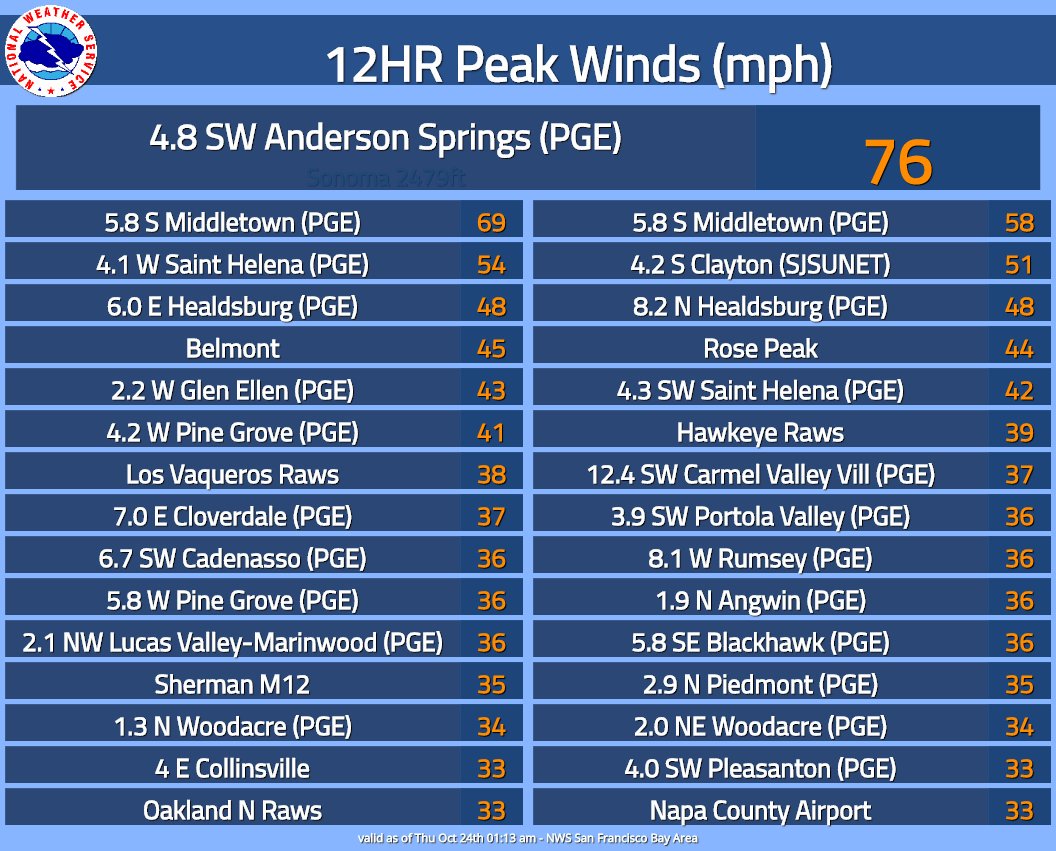
October is synonymous with pleasant weather around the Bay Area and locals refer to it as our “summer.” Offshore flow, wind flow from the land to the ocean, erodes low clouds and fog that bring June Gloom to San Francisco resulting in nice sunny days. Unfortunately, prevailing offshore flow can have a downside – increased fire weather concerns. Peak fire weather season in the Bay Area is generally focused late summer into early fall. This peak aligns with favored offshore flow and the tail end of the “dry season.” Of greatest concern is when offshore flow becomes strong and flows over the coastal mountains. Locally this wind is known as the Diablo Wind. For a great primer on Diablo Winds go here: (by Jan Null –San Francisco Meteorologist). Diablo Winds brought catastrophic damage during the devastating 2017 North Bay Firestorm. October 2019 was not immune to offshore flow and heightened fire weather concerns, and will go down in the record books as a historic month in terms of fire weather and number of Red Flag Warnings. 2019, unlike any other year in record, had four Red Flag Warnings, three of which fell within a ten day stretch and one standout lasting 36 hours. Some could argue that despite the separation time between each Red Flag Warning (conditions didn’t technically meet criteria or were borderline), fire weather conditions never really improved during the ten day stretch. Wind speeds may have had large swings, but relative humidity remained at impressively low levels. Single digit humidity readings were observed for a prolonged period, even at coastal locations. A wildfire erupted on the night of October 23 high in the hills of Sonoma County burning toward the towns of Healdsburg, Geyserville and Windsor. There was destruction, buildings were destroyed, evacuations occurred, the landscape changed - but unlike the fires of 2017, there were no lives lost. Onshore flow finally returned the first week of November with low clouds and fog moving inland. The Kindcade Fire was officially contained on November 6. Composed by: MMehle |
A meteor streaks across the night sky as gusty winds create an ember cast on a valley oak tree burned in the #Kincadefire early Wednesday morning in Knights Valley east of Healdsburg. |
|


.png)
.jpg)
.jpg)


.jpg)


.jpg)


