Severe thunderstorms are forecast through this weekend along a slow moving cold front and secondary storm system that will impact areas from the southern Plains to the Great Lakes. Large hail and isolated damaging wind gusts are the main threats with these storms along with a risk for heavy to excessive rainfall which could bring flooding. Read More >
| Atmospheric River April 4-7, 2018 | |||||||||||||||
|
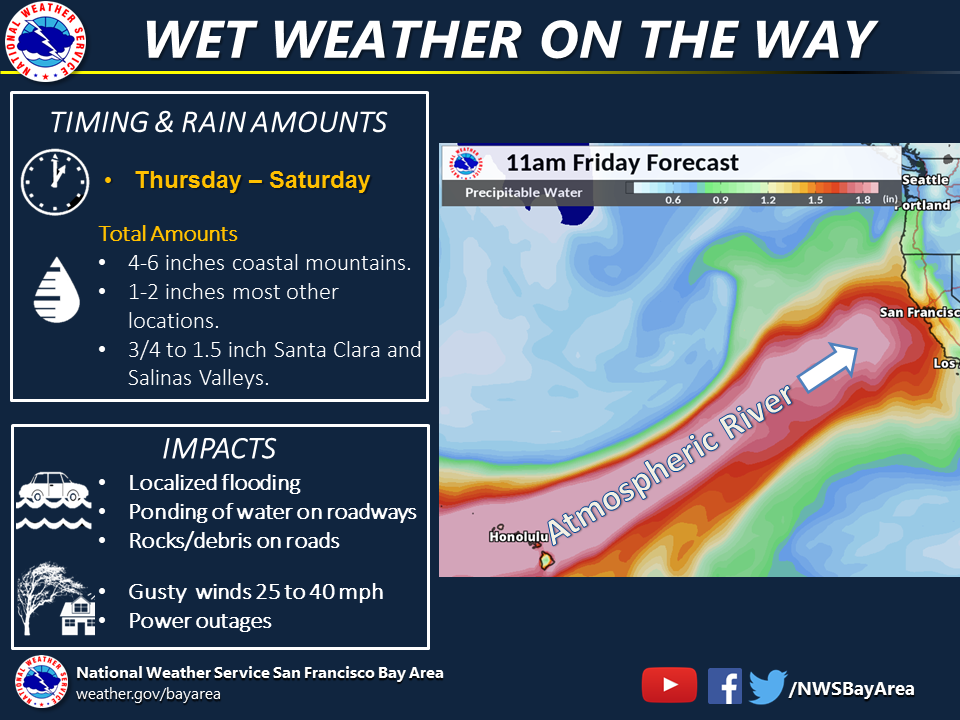
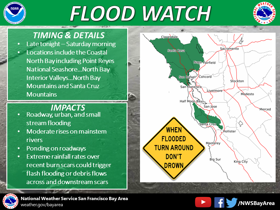
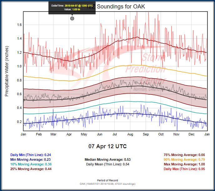
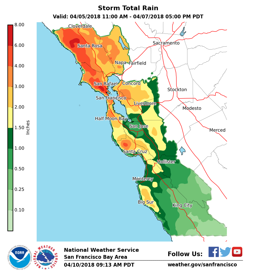
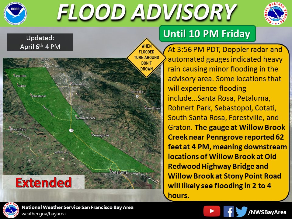
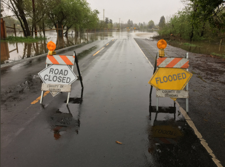
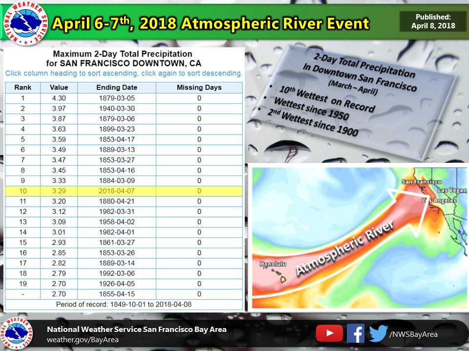
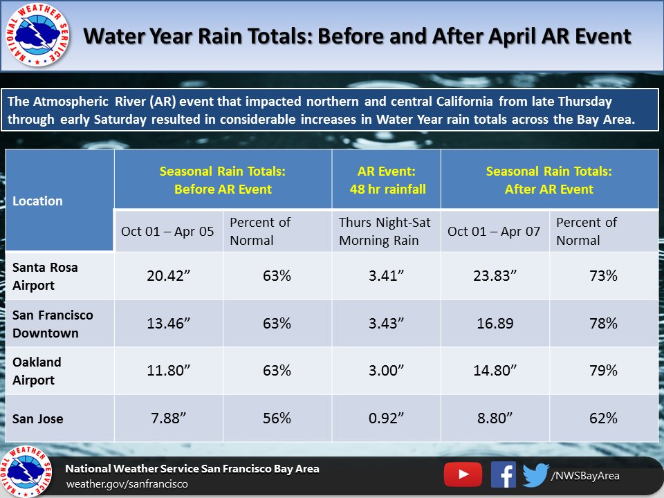
After what some have dubbed a "Mediocre" March (not much rainfall in March), the beginning of April had some hope as a historic Atmospheric River was set to take aim at California. The Winter of 2018 was rather dry as many climate stations were 40-60% percent of normal for rainfall. Simply put, California needed some precipitation as the climatological "wet season" clock was winding down. Before delving into the details, a little refresher on Atmospheric Rivers(AR) visit this website (http://www.esrl.noaa.gov/psd/atmrivers/). Long range models hinted at an AR impacting California far in advance, seven to ten days out in fact. It was rather remarkable that there was model consensus with such long lead time of an AR impacting California. One model depiction is listed below. As always, the devil is in the details and with ARs intensity and landfall location are key. Not only did the model guidance have consensus of an AR making landfall, but the moisture associated with the AR would approach record territory. In other words, the model forecast of Precipitable Water (PWAT) would approach all time record values for the balloon sounding climatological site Oakland, CA (KOAK). Despite the potential for all time record PWATs NWS Bay Area was not forecasting epic rainfall like the AR Event from 2017. Getting the word out - Leading up to the AR Event NWS Bay Area held numerous webinars/conference calls, issued partner briefing emails and posted lots of information via social media (see below). A Flood Watch was also issued for the North Bay and the Santa Cruz Mountains with heightened concern for the burn scar region of the North Bay. So, how did the AR Event play out? The very moist airmass plume was easily seen on satellite imagery initially making landfall across the North Bay/Mendocino County then drifting farther north for a brief period, but ultimately moving southward across the rest of the Bay Area. The balloon sounding at Oakland, CA, did in fact measure record PWAT values on two consecutive days, but fell short of all time record values. On day two (April 07, 2018) the balloon sounding recorded a PWAT of a whopping 1.69". In the absence of large scale forcing, record breaking rainfall was not observed. However, enough rain fell to cause minor/nuisance flooding across much of the Bay Area. Reports of flooding prompted NWS Bay Area to issue numerous Flood Advisories throughout the AR Event. Storm total rainfall amounts were greatest over the North Bay and Santa Cruz Mountains with a few locations reporting over 7" of rain (see below). Despite some impacts to the region, the AR brought much needed rain helping to nudge Percent of Normal values upward. It's a far cry from bringing climate sites back to normal rainfall, but this late in the wet season anything helps. (see stats below) Lastly, one other item of note were the high snow levels. Given the source region of the AR is generally in the sub-tropics associated airmasses are mild. This particular AR fit the bill with observed snow levels over 10,000 feet at Santa Rosa profiler. (see image below) |
|||||||||||||||
|
|||||||||||||||
| Local Storm Report | |||||||||||||||
PRELIMINARY LOCAL STORM REPORT...SUMMARY NATIONAL WEATHER SERVICE SAN FRANCISCO CA 847 AM PDT TUE APR 10 2018 ..TIME... ...EVENT... ...CITY LOCATION... ...LAT.LON... ..DATE... ....MAG.... ..COUNTY LOCATION..ST.. ...SOURCE.... ..REMARKS.. 0518 AM FLOOD 4 S SAN RAFAEL 37.92N 122.51W 04/06/2018 MARIN CA LAW ENFORCEMENT ROADWAY FLOODING REPORTED AT 53 SAN CLEMENTE DR. 0716 AM FLOOD 4 ESE LEVI STADIUM 37.38N 121.91W 04/06/2018 SANTA CLARA CA LAW ENFORCEMENT ROADWAY FLOODING REPORTED ON SB-87 TO SB-280 CONNECTING RAMP. 0925 AM FLOOD 3 ENE BODEGA 38.36N 122.92W 04/06/2018 SONOMA CA LAW ENFORCEMENT ROADWAY FLOODING REPORTED AT FREESTONE VALLEY FORD RD AND BODEGA HIGHWAY. 1007 AM FLOOD 1 N SEBASTOPOL 38.42N 122.83W 04/06/2018 SONOMA CA LAW ENFORCEMENT ROADWAY FLOODING REPORTED AT 1298 HIGH SCHOOL ROAD. ROADWAY COMPLETELY FLOODED VEHICLES REPORTEDLY HYDROPLANING. 1047 AM FLOOD 3 SW ROHNERT PARK 38.33N 122.74W 04/06/2018 SONOMA CA LAW ENFORCEMENT ROADWAY FLOODING REPORTED AT W SIERRA AVE AND STONY POINT ROAD. 1049 AM FLOOD 3 NW SANTA ROSA 38.49N 122.74W 04/06/2018 SONOMA CA LAW ENFORCEMENT ROADWAY FLOODING REPORTED AT OLD REDWOOD HIGHWAY AND ANGELA DR. 1057 AM FLOOD 1 W ROHNERT PARK 38.35N 122.72W 04/06/2018 SONOMA CA LAW ENFORCEMENT ROADWAY FLOODING REPORTED AT 6100 LABATH AVE. WATER ON BOTH SIDES OF ROAD. 1118 AM FLOOD 2 NW SANTA ROSA 38.48N 122.73W 04/06/2018 SONOMA CA LAW ENFORCEMENT ROADWAY FLOODING REPORTED AT OLD REDWOOD HIGHWAY AND MENDOCINO AVE. NB LANE IS HEAVILY FLOODED AND THE SB LANE IS STARTING TO FLOOD. 1135 AM FLOOD SE SONOMA RACEWAY 38.16N 122.45W 04/06/2018 SONOMA CA LAW ENFORCEMENT ROADWAY FLOODING REPORTED AT SR-121 AND SEARS POINT DR. SB LANE COMPLETELY FLOODED. 1158 AM FLOOD 5 NW PETALUMA 38.29N 122.69W 04/06/2018 SONOMA CA PUBLIC SOCIAL MEDIA PHOTO SHOWING FLOODING ON PEPPER ROAD IN WEST SONOMA COUNTY. 1158 AM FLOOD 5 NW PETALUMA 38.29N 122.69W 04/06/2018 SONOMA CA PUBLIC SOCIAL MEDIA PHOTO SHOWING ROADWAY FLOODING ON PEPPER ROAD. 1209 PM FLOOD 4 NW SEBASTOPOL 38.45N 122.87W 04/06/2018 SONOMA CA LAW ENFORCEMENT ROADWAY FLOODING REPORTED AT GREEN VALLEY RD AND SR-116. 1226 PM FLOOD 1 NNE ALAMEDA 37.76N 122.22W 04/06/2018 ALAMEDA CA LAW ENFORCEMENT ROADWAY FLOODING REPORTED AT I-880N AND HIGH STREET OFF RAMP. 1230 PM FLOOD 3 S SEBASTOPOL 38.35N 122.82W 04/06/2018 SONOMA CA LAW ENFORCEMENT ROADWAY FLOODING REPORTED AT BLOOMFIELD AND BLUCHER VALLEY. ENTIRE ROADWAY COVERED IN APPROX 2 FEET OF WATER. 1230 PM FLOOD 1 S BERKELEY 37.85N 122.30W 04/06/2018 ALAMEDA CA LAW ENFORCEMENT ROADWAY FLOODING REPORTED AT I-80W AND ASHBY OFF RAMP. 1230 PM FLOOD 3 SW WINDSOR 38.51N 122.84W 04/06/2018 SONOMA CA LAW ENFORCEMENT ROADWAY FLOODING REPORTED AT MARK WEST STATION RD AND STARR RD. 1234 PM FLOOD 2 S BERKELEY 37.84N 122.30W 04/06/2018 ALAMEDA CA LAW ENFORCEMENT ROADWAY FLOODING REPORTED AT I-80W AND POWELL STREET OFF RAMP. 1247 PM FLOOD 6 SE BODEGA 38.28N 122.90W 04/06/2018 MARIN CA LAW ENFORCEMENT ROADWAY FLOODING REPORTED AT SR-1 AND FALLON RD. 0100 PM DEBRIS FLOW CLOVERDALE 38.80N 123.02W 04/06/2018 SONOMA CA COUNTY OFFICIAL GEYERS ROAD BETWEEN PINE MOUNTAIN ROAD AND HALE RANCH IS CLOSED DUE TO A SLIDE. 0108 PM FLOOD 8 SW ROHNERT PARK 38.26N 122.78W 04/06/2018 SONOMA CA LAW ENFORCEMENT ROADWAY FLOODING AT BODEGA AVE AND VALLEY FORD RD. 0120 PM FLOOD 1 NNW AT&T PARK 37.78N 122.39W 04/06/2018 SAN FRANCISCO CA LAW ENFORCEMENT ROADWAY FLOODING REPORTED AT I-80W AND HARRISON ST OFF RAMP. 0130 PM FLOOD COTATI 38.33N 122.71W 04/06/2018 SONOMA CA COUNTY OFFICIAL WEST RAILROAD AVE CLOSED NEAR CYPRESS AVE DUE TO FLOODING. 0141 PM FLOOD 3 W SEBASTOPOL 38.39N 122.88W 04/06/2018 SONOMA CA LAW ENFORCEMENT ROADWAY FLOODING REPORTED AT SEXTON ROAD AND BODEGA HWY. 0144 PM FLOOD 5 SSW SONOMA 38.23N 122.50W 04/06/2018 SONOMA CA LAW ENFORCEMENT ROADWAY FLOODING REPORTED AT BROOKSIDE RD AND W AGUA CALIENTE RD. 0145 PM FLOOD BODEGA 38.35N 122.97W 04/06/2018 SONOMA CA COUNTY OFFICIAL BODEGA HWY AT SALMON CREEK CLOSED DUE TO FLOODING. 0147 PM FLOOD 3 S SEBASTOPOL 38.35N 122.81W 04/06/2018 SONOMA CA LAW ENFORCEMENT ROADWAY FLOODING REPORTED AT CANFIELD RD AND SCHAEFFER RD. 0247 PM FLOOD 5 NNW ALAMEDA 37.82N 122.27W 04/06/2018 ALAMEDA CA LAW ENFORCEMENT ROADWAY FLOODING REPORTED AT I980-E AND I-580 W CONNECTING. 0311 PM FLOOD 1 ENE BODEGA 38.35N 122.96W 04/06/2018 SONOMA CA LAW ENFORCEMENT ROADWAY FLOODING REPORTED AT JOY RD AND BODEGA HWY. 0315 PM FLOOD 3 S BERKELEY 37.83N 122.29W 04/06/2018 ALAMEDA CA LAW ENFORCEMENT ROADWAY FLOODING AT I-580W AND I-80E. 0324 PM FLOOD 9 WSW ROHNERT PARK 38.31N 122.85W 04/06/2018 SONOMA CA LAW ENFORCEMENT ROADWAY FLOODING AT VALLEY FORD RD AND BLOOMFIELD RD. 0420 PM DEBRIS FLOW 3 S ROHNERT PARK 38.30N 122.71W 04/06/2018 SONOMA CA LAW ENFORCEMENT MUDSLIDE REPORTED AT US-101N AND RAILROAD AVE. 0420 PM FLOOD 9 WSW ROHNERT PARK 38.31N 122.85W 04/06/2018 SONOMA CA LAW ENFORCEMENT ROADWAY FLOODING REPORTED AT VALLEY FORD AND BLOOMFIELD. 0519 PM DEBRIS FLOW 4 W BODEGA 38.34N 123.05W 04/06/2018 SONOMA CA LAW ENFORCEMENT MUD BLOCKING LANES AT SR-1 AND BAY HILL ROAD. 0921 PM FLOOD SAN FRANCISCO 37.77N 122.42W 04/06/2018 SAN FRANCISCO CA LAW ENFORCEMENT I-80 AT 7TH STREET IN SAN FRANCISCO. ALL LANES FLOODED. 1.5 FEET DEEP. 0124 AM FLOOD 4 WNW CONCORD 38.00N 122.07W 04/07/2018 CONTRA COSTA CA LAW ENFORCEMENT EB 80 ADJACENT TO THE POMONA ONRAMP, 2 FT OF WATER IN NUMBER 1 LANE 0220 AM FLOOD 1 ESE SAN FRANCISCO 37.77N 122.41W 04/07/2018 SAN FRANCISCO CA LAW ENFORCEMENT 6TH ST ONRAMP TO SB 280 8-10 INCHES OF WATER IN NUMBER 1-2 LANES 0301 AM DEBRIS FLOW 2 ENE HALF MOON BAY 37.48N 122.41W 04/07/2018 SAN MATEO CA LAW ENFORCEMENT LOTS OF ROCK IN ROADWAY 0302 AM FLOOD 5 SE FREMONT 37.48N 121.93W 04/07/2018 ALAMEDA CA LAW ENFORCEMENT NB 880 JUST SOUTH OF EXIT 12-A MISSION BLVD...5 INCHES OF WATER IN HOV LANE 0302 AM FLOOD 4 NNW BELMONT 37.57N 122.32W 04/07/2018 SAN MATEO CA LAW ENFORCEMENT US 101 AT 3RD AVENUE ONRAMP, SEVERE FLOODING IN 1 LANE. 0302 AM FLOOD 4 ESE BELMONT 37.49N 122.23W 04/07/2018 SAN MATEO CA LAW ENFORCEMENT SB 101 JUST NORTH OF RALSTON AVE 3 INCHES OF WATER IN 1 LANE. 0352 AM FLOOD 4 NNW BELMONT 37.57N 122.32W 04/07/2018 SAN MATEO CA LAW ENFORCEMENT US 101 N AT 3RD AVENUE ONRAMP, SEVERE FLOODING IN LANE NUMBER 1 0510 AM FLOOD 5 NE DALY CITY 37.74N 122.41W 04/07/2018 SAN FRANCISCO CA LAW ENFORCEMENT US 101 N AT ALEMANY BLVD OFFRAMP, NUMBER 1 LANE FLOODED, 6-8 INCHES DEEP 0626 AM FLOOD 2 NW BURLINGAME 37.61N 122.39W 04/07/2018 SAN MATEO CA LAW ENFORCEMENT US 101 NB AT SFO LARGE FLOODING NUMBER 1 LANE 0905 AM DEBRIS FLOW SSE JULIA PFEIFFER BURN 36.15N 121.67W 04/07/2018 MONTEREY CA LAW ENFORCEMENT CALIFORNIA HIGHWAY PATROL REPORTING MUD/DIRT/ROCK COVERING NORTHBOUND HWY 1 NEAR ANDERSON CANYON. && $$ |
MMEHLE