Morristown, TN
Weather Forecast Office
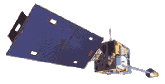
There are five geostationary meteorological satellites that provide images over the most the Earth. Geostationary satellites remain in sync with the earth's orbit, so they are stationary in relation to the surface of the earth. These satellites have the advantage of providing more frequent images than polar orbiting satellites since they remain in the same location.
The five geostationary weather satellites all orbit over the equator at a height of about 35,800 km. Japan's GMS remains near longitude 140 East and covers southeast Asia, Australia, and the Pacific Ocean. India's INSAT orbits at 75 East and covers southeast Asia, west Africa and the Indian Ocean. Europe's METEOSAT hovers near 0 degrees and overlooks Europe, Africa and the south Atlantic Ocean. The U.S. satellites are named Geostationary Operational Environmental Satellite (GOES) East and GOES West. GOES East orbits near longitude 75 West and provides coverage over the eastern U.S. and Canada, South America and the Atlantic Ocean. Goes West orbits near 135 W and covers the western U.S and Canada, Hawaii, Mexico and the Pacific Ocean.
The National Oceanic and Atmospheric Administration (NOAA)'s TIROS, the military's Defense Meteorological Satellite (DMSP) and Russia's METEOR are all polar orbiting satellites. They complete an orbit every 101-110 minutes.
US Dept of Commerce
National Oceanic and Atmospheric Administration
National Weather Service
Morristown, TN
5974 Commerce Blvd.
Morristown, TN 37814
(423) 586-3771
Comments? Questions? Please Contact Us.


 Local Radar
 Huntsville Radar
 Regional Satellite
 Graphical Forecast
 Weather Map
 Daily Graphics