|
- Several rounds of thunderstorms occurred over the Morristown County Warning Area (CWA) from April 30th through May 4th. These thunderstorms significantly soaked the ground in various locations and raised the level of some streams and lakes in the area. On May 5th, a warm front lay across extreme east Tennessee with a cold front located over Arkansas. Most of east Tennessee was located in the warm sector of this frontal system with dewpoint temperatures in the lower 60s (resulting in a high atmospheric moisture content). A large atmospheric blocking pattern was located across the United States, which caused the normal west-to-east progression of weather systems to become nearly stationary.
- A large area of rain with embedded thunderstorms began to move eastward across the area early on May 5th, producing locally heavy rains. A surface high pressure area over the Gulf of America and western Atlantic, combined with the stationary frontal system over the Tennessee Valley, allowed southerly winds to strengthen across the area from the Gulf Coastal region. These southerly winds continued to bring abundant moisture into the southern Appalachian region, with dewpoint temperatures rising into the upper 60s on the 6th and 7th. The showers and thunderstorms which developed over the Tennessee Valley began to ‘train’ over the same areas causing continuous heavy rainfall across southeast Tennessee and extreme southwest North Carolina. During the four day rain event (beginning at midnight on May 5th and ending at midnight on May 8th), a bull’s eye of over twelve inches of rain was reported in McMinn County, TN at both Etowah and Athens. The heaviest rains fell during the first 35 hours (midnight May 5th through 11:00 P.M. May 6th), where 11.6 and 11.1 inches fell at Etowah and Athens, respectively. Storm total rainfall of greater than six inches fell somewhere in each county south of a Sevier to Morgan County line. In the Little Tennessee River and Hiwassee River basins, greater than nine inches fell during the entire event. All of this water drained into Watts Bar and Chickamauga Lakes, which eventually flowed down to Chattanooga.
- This ‘training’ of heavy rain fell over a relatively small area, all of which drained into the Tennessee River either slightly above or directly into the city of Chattanooga, TN. The heaviest rains fell across the Hiwassee River basin, which then drains into Chickamauga Lake. Both the Apalachia and Hiwassee Dams on the Hiwassee River in North Carolina were forced to spill water from the heavy rains across western North Carolina and northern Georgia. Also, the South Chickamauga Creek in Chattanooga (the headwaters of which lie in northwest Georgia) reached a record flood stage at the gage in East Ridge, TN. This gage lies well upstream of the creek’s confluence with the Tennessee River and is not affected by back water from the Tennessee River. However, the mouth of the creek is subject to backwater influences from the Tennessee River mainstem. Heavy rains across the South Chickamauga basin in northwest Georgia and portions of southeast Tennessee caused a new record flood stage on the South Chickamauga Creek of 29.32 feet on May 8th. The previous record stage was 28.72 feet observed in February 1990.
- The Tennessee River at Chattanooga reached 36.1 feet on May 8th as well. The modern record flood is 36.9 feet oberved in February 1973. In 1867, well before flood control developed on the Tennessee River, the gage at Chattanooga reached over 58 feet. The flood of May 2003 caused the evacuation of hundreds of people, and damage to private and public property initially estimated to approach $20 million in Hamilton County alone. Significant damage with numerous rescues and evacuations occurred in many of the counties across southeast Tennessee and central east Tennessee.
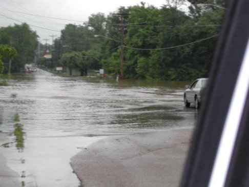
Pictures of the May 2003 Flooding across Southeast Tennessee
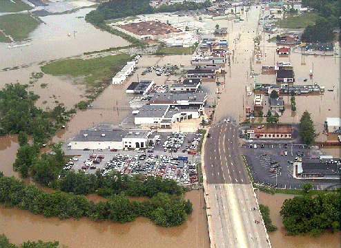
View of Lee Highway looking northeast near South Chickamauga Creek and Lovell Field.
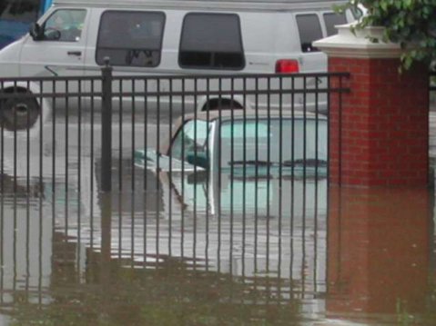
View of the parking lot at apartments located on the north shore of the Tennessee River in downtown Chattanooga.
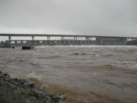
View from the northern shore of Chickamauga Dam in Chattanooga. Flood waters are rushing through the locks. Picture taken the afternoon of May 7, 2003.
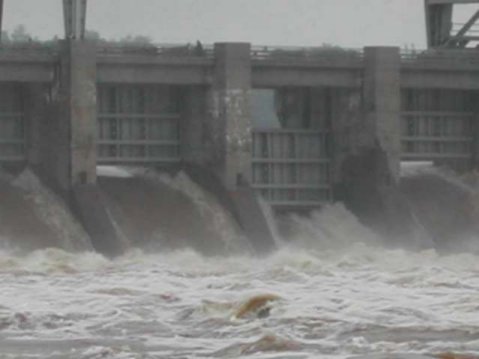
Chickamauga Dam located in Chattanooga - dangerous fast-moving flood waters rush through the locks on day 1 of flooding. Picture taken May 7, 2003 at 4 pm.

View of the entrance directional sign going into a plant located on Amnicola Highway in Chattanooga. The sign is approximately 5 feet from the ground. Picture taken the afternoon of May 7, 2003.

View of the backyard and garden of Hugh Wooden along Davidson Road in Chattanooga. The water was about 12 feet deep at the lowest point in his yard. In the far distance, you can see the railroad track bed which is about 14 feet above the surrounding area. Picture taken May 7, 2003 at 8 pm.
Mr. Wooden's backyard and garden after the flooding.
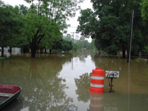
View of Brown's Ferry Road north of I-24 (west of downtown Chattanooga in Hamilton County). The only thing that gives evidence of a road are the mailboxes that are lined up on either side of the road. Picture taken May 8, 2003.
View of Brown's Ferry Road at I-24 west of Chattanooga. Picture taken May 8, 2003.
-
The following rivers flooded and are listed with their crest heights and dates:
River Crest (feet) Date
Sequatchie River near Whitwell, TN 17.86 May 7
Sewee Creek near Decatur, TN 15.35 May 7
Valley River at Tomotla, NC 13.06 May 7
French Broad River near Newport, TN 14.50 May 7
Pigeon River at Newport, TN 17.67 May 7
Little Pigeon River above Sevierville, TN 13.88 May 7
- The above rivers (and many others which ran very high but did not reach flood) all flow into the Tennessee River above Chattanooga. The exceptions are the Sequatchie River and the South Chickamauga Creek which flow into the Tennessee River at Nickajack Lake (below Chattanooga). This made flooding worse upstream, because of the difficulty of drawing down Nickajack Lake to allow the mainstem flooding upstream (above Chattanooga) to lower.
- The rain, and flooding on the South Chickamauga Creek, finally ended on May 10th, but flood waters continued on the Tennessee River until May 11th.
|


 Local Radar
 Huntsville Radar
 Regional Satellite
 Graphical Forecast
 Weather Map