- On August 3, 2001, a nearly tropical environment was in place over the Southern Appalachian region. The moisture content of the atmosphere was very high, even for summer. An upper level disturbance was moving southeast toward the region embedded in very weak northwest flow aloft. This weak flow aloft is often observed during flash flooding events, since the thunderstorms that develop consequently move very slowly, contributing to excess rainfall over the same areas. Rainfall on August 3rd began in the eventual flooding area around 10:30 pm, according to eyewitness accounts, and continued through early afternoon on Saturday Aug 4th. Serious flooding, which threatened homes, first began around 3:00 am EDT. The rainfall continually redeveloped over the same areas of Greene County, and eventually drifted south into eastern Cocke County.
- It appears that the mountainous terrain was a key factor in enhancing the rainfall. The rainfall maximum occurred where the elevation changes from around 1500 feet to over 4300 feet in a distance of about 9 miles. However, why the event occurred in this particular location (other dramatic elevation rises occur nearby, as well) is not known. There were no fronts or boundaries discernable in the vicinity. It is possible that surface disturbances or outflow boundaries from the showers themselves interacted with each other and caused the storms to persist in the same general area. If they did occur, these outflows were either weak or were too shallow to be picked up on radar. This is a fairly common occurrence during the summer months.
- Accurate rainfall data have been difficult to obtain. Some automated rain gauges in the area had been reporting questionable amounts and were under scrutiny at the time. An unofficial gage at Viking Mountain (4952 feet MSL), located approximated 7 miles southwest of the radar-indicated maximum, measured 15.35 inches from "Friday evening" until "Saturday morning" (the road was out and the observer had to hike up to the gage). A man on Big Creek (a tributary of Horse Creek in Greene County) who lived very close to the radar-indicated maximum emptied his 5-inch gage twice during the event. All he could say for certain was that he "had more than 10 inches of rain". It is entirely possible that he had significantly more than 10 inches, since he was not able to determine how much overflowed the gauge before he could reach it to empty it. Many people in the Horse Creek area felt that they had over 10 inches of rain, and some indicated that 12 to 15 inches of rain was not an unreasonable estimate. An attempt at a bucket survey was fruitless (all the buckets must have washed away...).
- Happily, no serious injuries or fatalities occurred as a result of this flood.
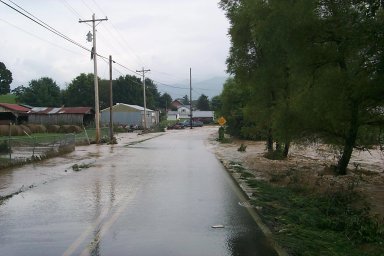
Looking south, just south of Highway 107, on Horse Creek in southeast Greene County. The creek here is normally about 20 feet wide. This is the Monday after the Saturday flooding. The water damaged the road bed, but left the asphalt intact. If you drive your car on the thin asphalt crust, you will end up in the creek.
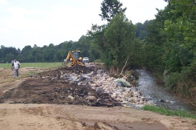
Further south (upstream) on Horse Creek. This creek is about 6 feet wide here, still wider than normal at this location. You can see that the entire road was taken out at this point and that the creek deposited mud and sand well off the picture to the left.
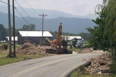
This unknown road was damaged under the asphalt. The leftover asphalt will support a person walking on it, but a car driven over it would fall into the hole created under the asphalt. Never drive onto flooded roads!
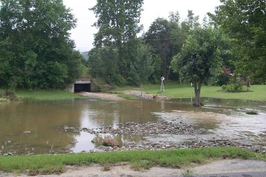
This is Big Creek, and the culvert through which it flows is under Highway 107 in southeast Greene County. Normally, this little creek is about 18 inches wide and a few inches deep. It flows through a yard over the sod. Two full days after the worst flooding, it is still over 100 feet wide, and the channel through which it flows is now 6 feet deep. The pile of rocks near the windmill was left by the creek. At its height, the water reached the house on the right (out of the picture).
Horse Creek never quite reached this house (you can see the thin line of debris in the front yard). But it took great gouges out of the bank as it thundered by. This bank will likely never be the same, and the next flood will more easily eat away more of it.
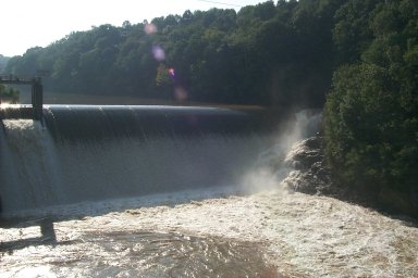
Standing on the Highway 70 bridge over the Nolichucky River at the Nolichucky Dam. The water is gushing around the left shoulder (right side of the picture) of the dam. One official reported the water to be hitting the bridge, prompting the closing of the road, and later inspection of the bridge. The bridge survived without damage, as it was designed to allow water to pass over it. Notice the water on the right side of the picture coming away from the dam (flowing toward you). The water on the left side of the picture, just a few tens of feet away, is actually flowing TOWARD the dam. This channel set up a curious flow pattern with whirlpools and eddies in the current.
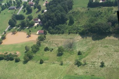
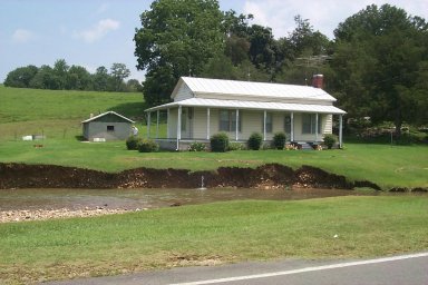
Flood waters flowed from right to left across this picture. You can see the small channel dug into the ground on the right side of the image. The pond on the left inundated the outbuilding in the center. Since there is no place for the water to drain, ponds like these become breeding grounds for mosquitos.
Upstream on Horse Creek. The road was completely washed out here.
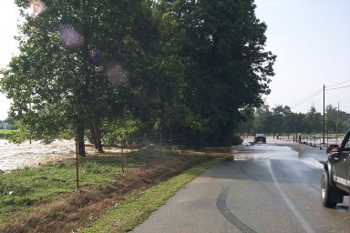
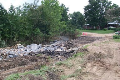
Horse Creek is normally about 15-30 feet wide here. Here, two days after the worst flooding, the creek was still over 100 yards wide. At the height of the event, it was likely around 200 yards wide. You can see on the right side of the image, water still trying to find its way back into the creek.
|


 Local Radar
 Huntsville Radar
 Regional Satellite
 Graphical Forecast
 Weather Map