Overview
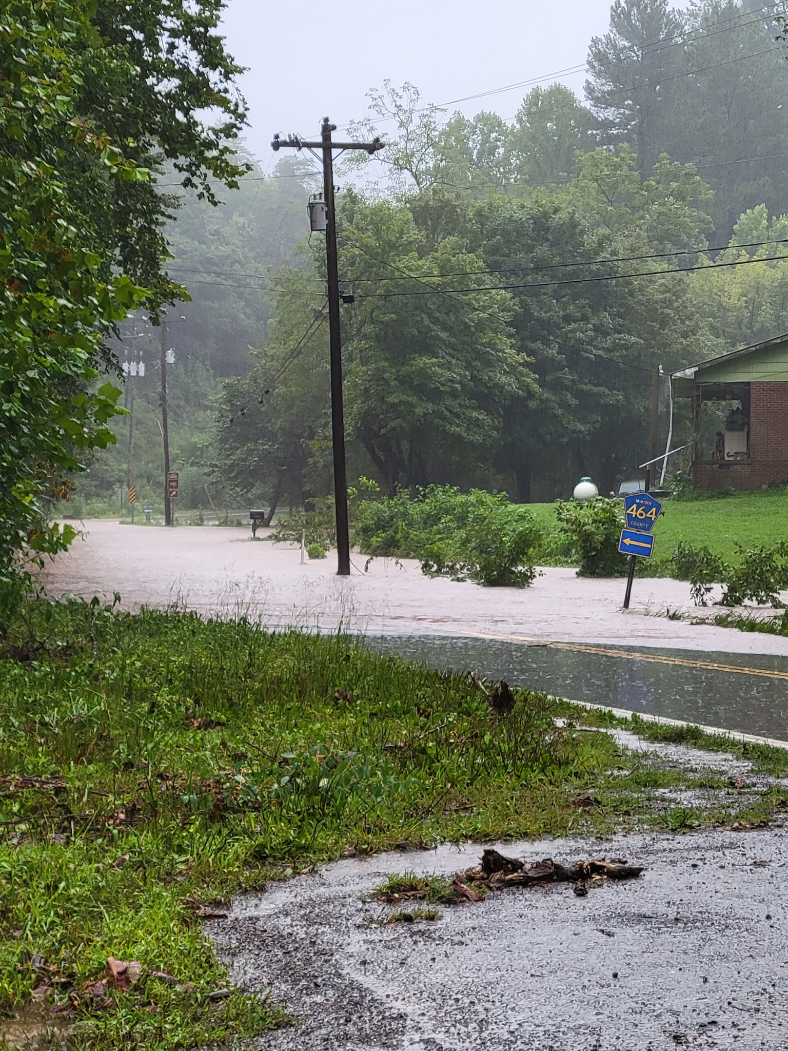
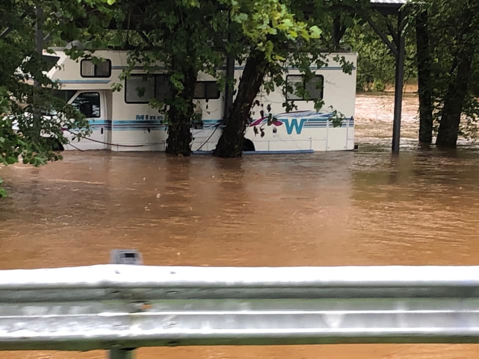
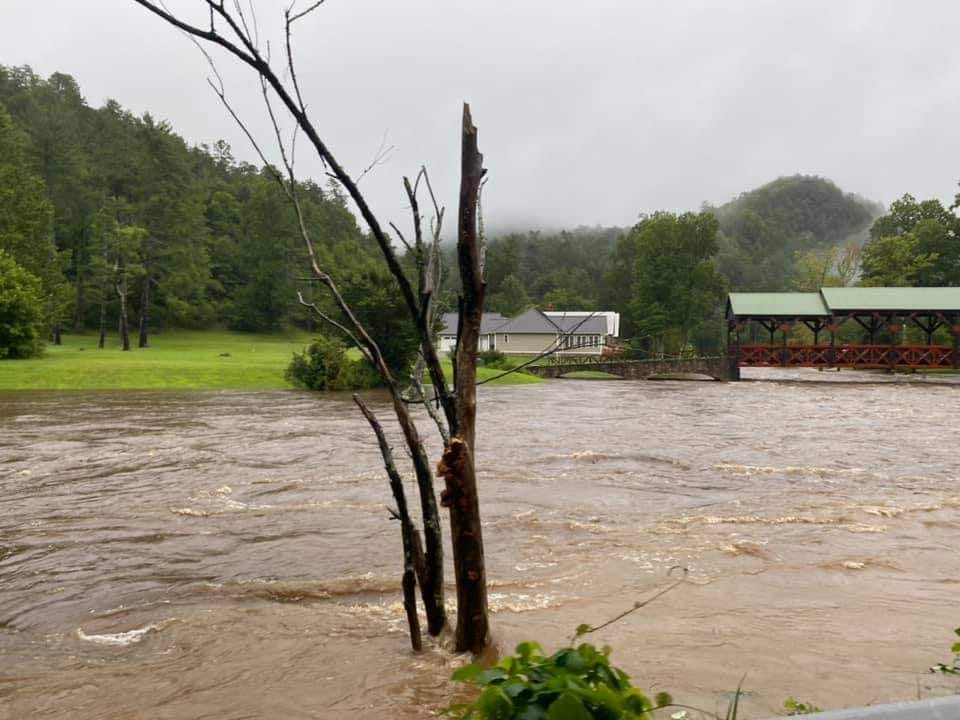
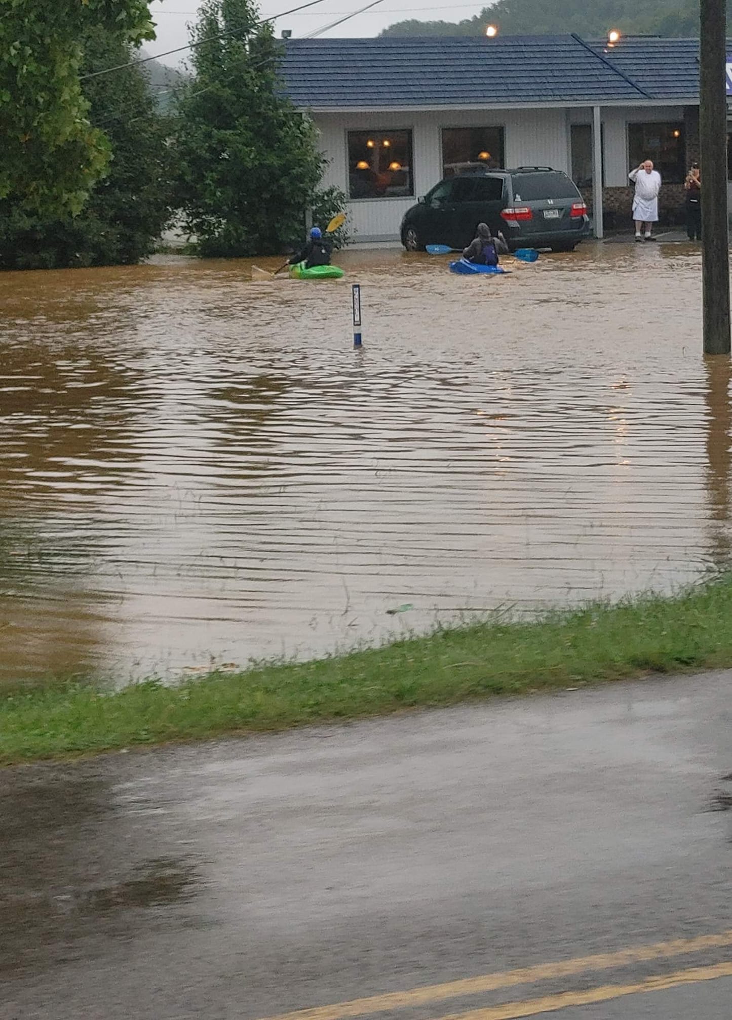
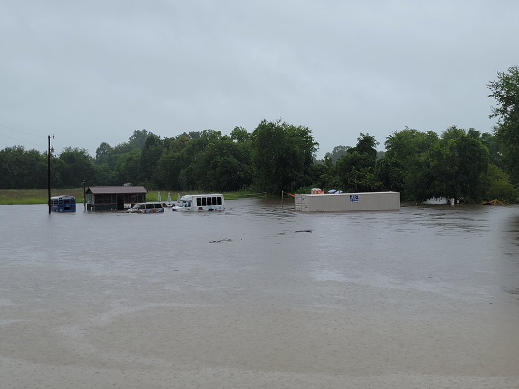
Tropical Storm Fred made landfall along the northern Gulf Coast on August 16th before its remnants moved through the southern Appalachians. Widespread, persistent rainfall resulted with some areas seeing locally heavy amounts. While the more notable impacts from flooding as well as wind and even tornadoes were south and east of our area, localized river and non-river flooding did still occur and caused multiple road closures and even some evacuations in Cocke County.Flooding
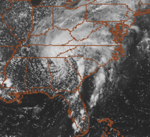
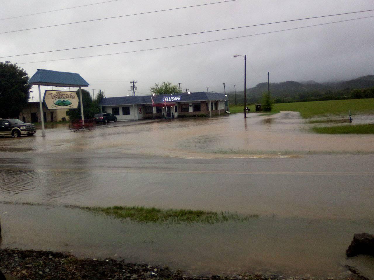
The Pigeon River near Newport notably exceeded the major flooding threshold as can be seen from the observed blue line in the hydrograph below. Nearby, the French Broad River crested at 14.75 feet, only 1.25 feet from moderate flood stage. The Little Pigeon near Sevierville crested at 10.81 feet, only missing minor flood stage by 0.19 feet, or just over 2 inches. In addition, the Tellico River overflowed its banks leading to significant flooding in Tellico Plains. Satellite imagery of Tropical Storm Fred in the Gulf and also moving into the area can be seen below as well as a regional radar loop from 1 AM Tuesday through Midnight Wednesday that captures the steadiest and most widespread rainfall. The river flooding took place several hours after the bulk of the rain had fallen as runoff from the mountains and areas surrounding the rivers caused the rivers to rise significantly.
Hydrographs
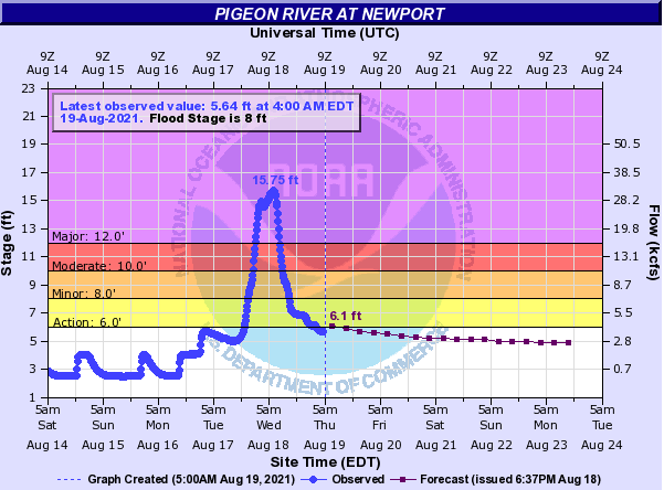 |
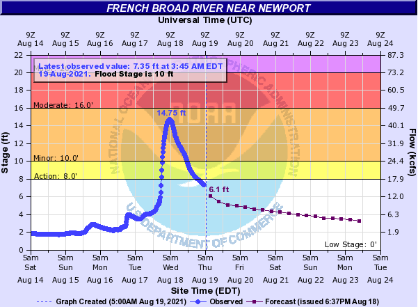 |
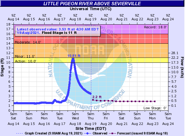 |
| Pigeon River near Newport | French Broad River near Newport | Little Pigeon River near Sevierville |
Satellite and Radar Imagery
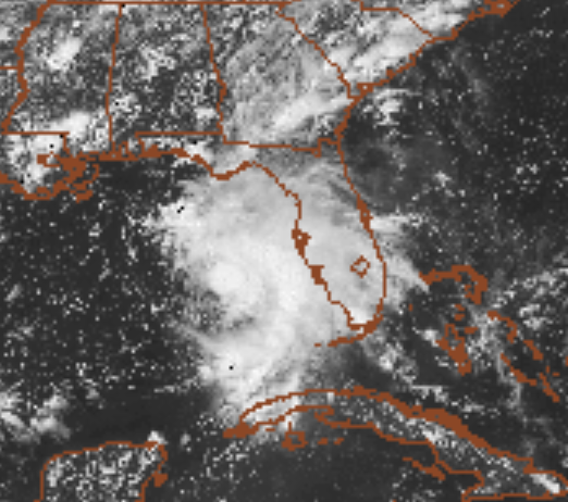 |
 |
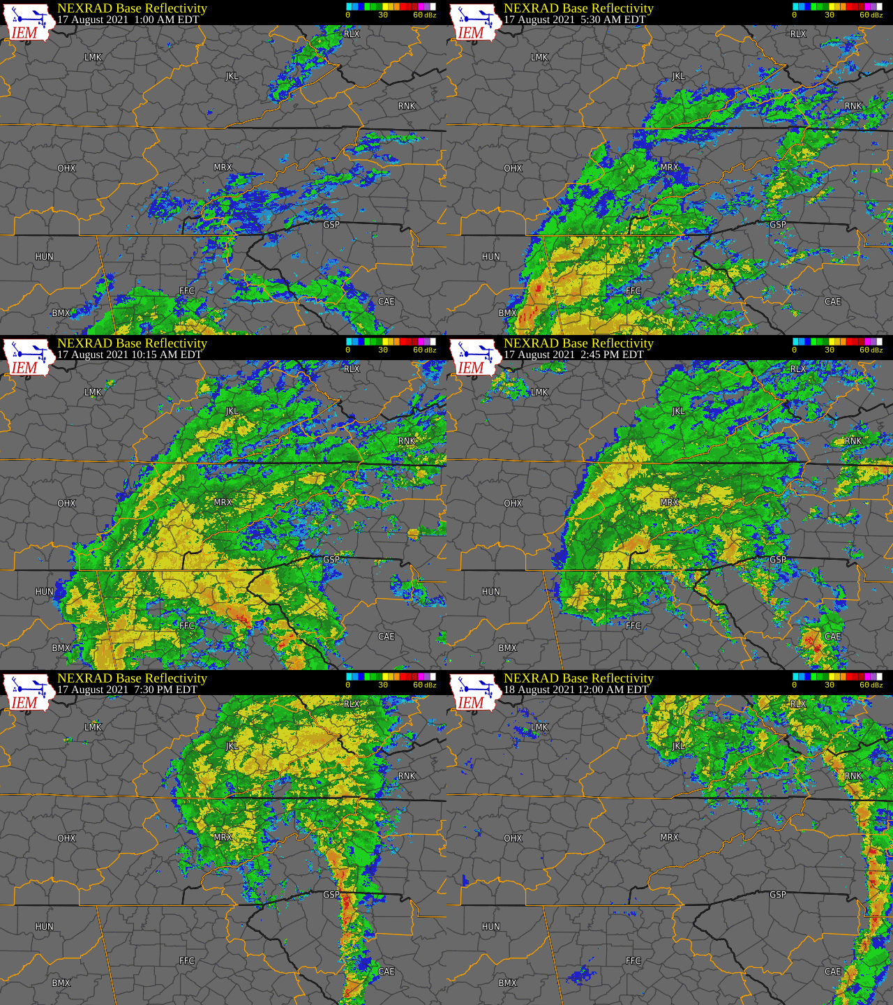 |
| Visible Satellite Imagery of TS Fred on 08/15, before Landfall | Visible Satellite Imagery of TS Fred Inland on 08/17 | Radar Loop of TS Fred from 1 AM EDT 08/17 through 12 AM EDT 08/18 |
Photos & Video
 |
 |
 |
 |
| Tellico Plains, TN (Rebecca Webb) |
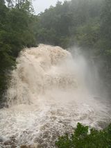
Bald River Falls Tellico Plains, TN (Sherry Bryson) |
Englewood, TN (Paige Ellison Lange) |
Warne, NC (Chris Batchelder) |
 |
 |
 |
 |
| Tellico Plains, TN (Jill Ballew) |
Tellico Plains, TN (Jill Ballew) |
Tellico River in Tellico Plains, TN (Norman Mountain and Ken Weathers) |
Tellico Plains, TN (WVLT-TV 8 and Monroe Co. 911) |
.PNG) |
| Dry Creek Rd - Tellico Plains, TN (WVLT-TV 8) |
Rain Reports
Location                     Amount    Time/Date       Lat/Lon/Elev (ft.)

...North Carolina...

...Cherokee County...
3.4 N Marble                 7.92 in   0900 PM 08/17   35.22N/83.92W/3260
Murphy                       5.52 in   0747 AM 08/18   35.11N/84.01W/1640
0.6 W Murphy                 4.37 in   0600 AM 08/18   35.09N/84.04W/1519
Andrews NC                   3.86 in   0755 AM 08/18   35.18N/83.85W/2157
1.1 NE Marble                3.80 in   0600 AM 08/18   35.19N/83.92W/1742
Hiawasse Dam                 3.76 in   0600 AM 08/18   35.15N/84.18W/1374
Murphy 15.7 WSW              2.96 in   0613 AM 08/18   35.00N/84.28W/2156
Murphy 12.1 WSW              2.90 in   0750 AM 08/18   35.00N/84.21W/1912

...Clay County...
Rainbow Springs              4.93 in   0755 AM 08/18   35.08N/83.59W/3917
Chatuge Dam                  3.35 in   0600 AM 08/18   35.02N/83.79W/1827

...Tennessee...

...Anderson County...
1.8 W Norris                 2.66 in   0600 AM 08/18   36.22N/84.09W/1020
Norris 0.6 NW                2.56 in   0700 AM 08/18   36.20N/84.08W/1158
5 NE Oak Ridge               2.02 in   0700 AM 08/18   36.02N/84.23W/863
3.7 NW Karns                 1.94 in   0600 AM 08/18   36.02N/84.16W/813
Oak Ridge                    1.78 in   0753 AM 08/18   36.02N/84.23W/902
Oak Ridge 5.7 NE             1.78 in   0800 AM 08/18   36.02N/84.22W/885
4 NNE Oak Ridge              1.35 in   0805 AM 08/18   36.02N/84.26W/839

...Bledsoe County...
Graysville 5.5 WNW           1.33 in   0700 AM 08/18   35.47N/85.18W/1943
Pikeville                    1.03 in   0600 AM 08/18   35.61N/85.19W/875
1 SSE Pikeville              0.50 in   0805 AM 08/18   35.59N/85.19W/863

...Blount County...
Indian Grave Gap (2 N Cades  4.49 in   0755 AM 08/18   35.62N/83.81W/2700
Townsend 5 S                 4.08 in   0700 AM 08/18   35.60N/83.78W/1877
4 SSE Greenback              3.76 in   0650 AM 08/18   35.60N/84.14W/892
1.6 E Cades Cove             3.74 in   0700 AM 08/18   35.60N/83.78W/2700
Friendsville 2.3 ESE         3.68 in   0600 AM 08/18   35.74N/84.09W/1145
Maryville 4.1 SSW            3.67 in   0800 AM 08/18   35.70N/84.01W/1160
Knoxville McGhee Tyson       3.30 in   0753 AM 08/18   35.82N/83.98W/962
2.1 E Wildwood               3.28 in   0600 AM 08/18   35.81N/83.84W/1053
4 S Maryville                3.09 in   0700 AM 08/18   35.68N/83.98W/1070
3 WSW Alcoa                  2.63 in   0804 AM 08/18   35.77N/84.03W/960
Maryville 3.4 ESE            2.33 in   0700 AM 08/18   35.74N/83.91W/1016
Maryville                    1.43 in   0756 AM 08/18   35.74N/83.98W/1000

...Bradley County...
Cleveland 3.0 ESE            4.15 in   0715 AM 08/18   35.16N/84.82W/977
Cleveland 5.2 SE             3.98 in   0700 AM 08/18   35.12N/84.81W/1029
1.3 NE Tasso                 3.42 in   1200 AM 08/18   35.22N/84.80W/800
Waterville                   2.47 in   0520 AM 08/18   35.11N/84.87W/939
1.6 SW Tasso                 2.17 in   0600 AM 08/18   35.18N/84.82W/849
0.8 SW Charleston            2.12 in   0600 AM 08/18   35.28N/84.77W/872

...Campbell County...
Newcomb                      1.34 in   0600 AM 08/18   36.54N/84.17W/984

...Carter County...
4.0 SE Hunter                2.80 in   0600 AM 08/18   36.33N/82.13W/1778
Burbank                      2.61 in   0600 AM 08/18   36.15N/82.10W/2990
Elizabethton                 2.57 in   0700 AM 08/18   36.35N/82.25W/1487
2.6 N Milligan College       2.50 in   0600 AM 08/18   36.31N/82.31W/1745
Roan Mountain 7.1 W          2.20 in   0800 AM 08/18   36.19N/82.20W/2722

...Claiborne County...
Powell River                 2.02 in   0600 AM 08/18   36.54N/83.63W/1095
0.7 W Speedwell              1.37 in   0600 AM 08/18   36.46N/83.88W/1125

...Cocke County...
Del Rio 4se                  3.58 in   0600 AM 08/18   35.89N/82.97W/1560
1.0 NW Newport               3.47 in   0600 AM 08/18   35.97N/83.20W/1080
Cosby                        3.36 in   0600 AM 08/18   35.81N/83.25W/1358

...Grainger County...
3.5 N Jefferson City         4.97 in   0600 AM 08/18   36.17N/83.50W/1048
0.7 NE Washburn              2.35 in   0600 AM 08/18   36.30N/83.59W/1417

...Greene County...
Chuckey 1wnw                 2.85 in   0600 AM 08/18   36.22N/82.70W/1500
Nolichucky (4 SE Cedar Creek 2.63 in   0759 AM 08/18   35.98N/82.84W/2299
Greeneville 10.1 S           2.47 in   0700 AM 08/18   36.02N/82.83W/1460
Greeneville 3.0 S            2.41 in   0700 AM 08/18   36.12N/82.82W/1533
Baileyton 1.0 NW             2.29 in   0700 AM 08/18   36.34N/82.84W/1193
3.6 NE Cedar Creek           1.20 in   0715 AM 08/18   36.07N/82.87W/1309

...Hamblen County...
Morristown                   5.39 in   0700 AM 08/18   36.21N/83.33W/1344
WFO Morristown               4.74 in   1200 AM 08/18   36.17N/83.40W/1320
2.0 NW Russellville          4.62 in   0600 AM 08/18   36.27N/83.23W/1171
Hamblen Co. Hq               4.24 in   0705 AM 08/18   36.26N/83.28W/1163
Jefferson City 2.1 NE        4.15 in   0800 AM 08/18   36.16N/83.46W/1245
Bulls Gap 3.6 W              4.04 in   0700 AM 08/18   36.27N/83.14W/1214

...Hamilton County...
1 E Harrison                 5.60 in   0700 AM 08/18   35.12N/85.12W/900
Ooltewah 7.3 NNE             4.50 in   0600 AM 08/18   35.16N/85.05W/719
Ooltewah 6.7 NNE             4.44 in   0500 AM 08/18   35.15N/85.05W/699
Chattanooga 5.1 ENE          1.82 in   0700 AM 08/18   35.10N/85.18W/718
2.8 NE Chattanooga           1.68 in   0600 AM 08/18   35.10N/85.23W/673
Ooltewah 3.0 SW              1.65 in   0700 AM 08/18   35.04N/85.09W/931
2 W Ooltewah                 1.37 in   0800 AM 08/18   35.06N/85.14W/753
1 NE Signal Mountain         1.29 in   0700 AM 08/18   35.15N/85.32W/1956
2 NE Ooltewah                1.20 in   0805 AM 08/18   35.08N/85.06W/685
3 ESE Lone Oak               1.12 in   0800 AM 08/18   35.18N/85.31W/1914
Chattanooga Airport          1.12 in   0753 AM 08/18   35.03N/85.20W/672
2.2 NW Middle Valley         1.07 in   0700 AM 08/18   35.21N/85.22W/670
2 S Chattanooga              0.90 in   0805 AM 08/18   35.03N/85.26W/856
2 NNW Signal Mountain        0.84 in   0805 AM 08/18   35.16N/85.36W/1814

...Hancock County...
3.7 N Sneedville             4.23 in   0600 AM 08/18   36.59N/83.23W/1515

...Hawkins County...
John Sevier Steam Plant      2.47 in   0600 AM 08/18   36.38N/82.96W/1100
Bulls Gap 0.9 SSW            2.46 in   0600 AM 08/18   36.25N/83.09W/1162
Church Hill 3.4 NNE          2.43 in   0700 AM 08/18   36.57N/82.68W/1450
Church Hill 1w               2.16 in   0600 AM 08/18   36.52N/82.74W/1302
Chuckey                      2.14 in   0757 AM 08/18   36.36N/82.99W/1152

...Jefferson County...
3.8 W Baneberry              3.58 in   0600 AM 08/18   36.04N/83.34W/1082
White Pine                   3.48 in   0804 AM 08/18   36.10N/83.30W/1171

...Johnson County...
1.1 E Trade                  2.41 in   0600 AM 08/18   36.34N/81.73W/3200
4.1 NE Doeville              2.35 in   0600 AM 08/18   36.44N/81.94W/2349
Mountain City                1.64 in   0804 AM 08/18   36.48N/81.80W/2520

...Knox County...
Farragut 2.8 ENE             2.59 in   0700 AM 08/18   35.89N/84.14W/1066
Knoxville                    2.50 in   0100 AM 08/18   35.90N/84.00W/1049
Knoxville 5.5 W              2.44 in   0700 AM 08/18   35.98N/84.04W/1306
2.2 SE Knoxville             2.27 in   0600 AM 08/18   35.95N/83.93W/850
Knoxville 5.7 NNW            2.26 in   0700 AM 08/18   36.05N/83.99W/1014
Beaver Creek                 2.19 in   0730 AM 08/18   36.02N/84.05W/1000
3.8 NW Halls                 1.94 in   0745 AM 08/18   36.11N/83.99W/869
3.5 W Karns                  1.82 in   0710 AM 08/18   35.97N/84.18W/892
Farragut 2.3 NE              1.77 in   0700 AM 08/18   35.90N/84.15W/1018
Seymour 5.8 N                1.76 in   0700 AM 08/18   35.96N/83.77W/838

...Loudon County...
1.3 E Greenback              3.56 in   0600 AM 08/18   35.65N/84.15W/856
Loudon 5.1 ESE               2.79 in   0700 AM 08/18   35.71N/84.27W
3 S Lenoir City              2.53 in   0800 AM 08/18   35.75N/84.27W/856
1.5 E Lenoir City            2.26 in   0600 AM 08/18   35.79N/84.25W/785
5.4 S Oak Ridge              2.01 in   0600 AM 08/18   35.88N/84.30W/784
Lenoir City Lookout Twr      1.80 in   0705 AM 08/18   35.84N/84.33W/1240

...Marion County...
5.7 N Lookout Mountain       1.38 in   0600 AM 08/18   35.06N/85.39W/1680
4.0 S Jasper                 0.70 in   0600 AM 08/18   35.00N/85.62W/608
4.8 SE Powells Crossroads    0.70 in   0706 AM 08/18   35.13N/85.43W/1920
Prentice Cooper Sf           0.67 in   0706 AM 08/18   35.13N/85.43W/1919
Jasper 1.7 N                 0.43 in   0700 AM 08/18   35.08N/85.63W/652
0.6 N Whitwell               0.43 in   0600 AM 08/18   35.21N/85.52W/725

...McMinn County...
Rockwood 11.3 S              4.16 in   0651 AM 08/18   35.64N/84.62W/839
0.8 SE Etowah                3.06 in   0600 AM 08/18   35.33N/84.52W/823
Athens                       2.86 in   0700 AM 08/18   35.47N/84.59W/959
Etowah                       2.52 in   0804 AM 08/18   35.33N/84.54W/889

...Meigs County...
Outside City Limits          2.27 in   0729 AM 08/18   35.57N/84.79W/700
Ten Mile 2.2 NW              1.96 in   0700 AM 08/18   35.68N/84.71W/781
Decatur                      1.67 in   0600 AM 08/18   35.52N/84.80W/708
2.7 NW Georgetown            1.07 in   0600 AM 08/18   35.32N/84.97W/810

...Monroe County...
1.8 NW Tellico Plains        3.50 in   0600 AM 08/18   35.38N/84.32W/994
0.6 SE Sweetwater            2.42 in   0700 AM 08/18   35.59N/84.46W/916

...Morgan County...
Harriman 4.1 NNE             1.56 in   0700 AM 08/18   35.99N/84.55W/1089
Petros                       1.24 in   0600 AM 08/18   36.09N/84.44W/1347
Petros                       1.23 in   0600 AM 08/18   36.10N/84.45W/1391
Sunbright                    0.78 in   0600 AM 08/18   36.23N/84.68W/1468
1.2 NW Wartburg              0.73 in   0600 AM 08/18   36.11N/84.60W/876

...Polk County...
Benton 2.3 ESE               4.36 in   0532 AM 08/18   35.17N/84.61W/943
Ocoee (3 Sw Reliance)        3.42 in   0705 AM 08/18   35.16N/84.59W/1321
1.5NW Mccaysville-Copperhill 3.19 in   0600 AM 08/18   35.00N/84.39W/1604
6.6 S Bullet Creek           3.19 in   0600 AM 08/18   35.18N/84.44W/912
Delano                       2.97 in   0706 AM 08/18   35.25N/84.58W/694
Parksville                   2.83 in   0600 AM 08/18   35.09N/84.65W/812

...Rhea County...
1.9 SW Peakland              2.59 in   0600 AM 08/18   35.61N/84.79W/764
Dayton                       1.69 in   0600 AM 08/18   35.50N/85.02W/741
2.3 W Eagle Furnace          1.27 in   0600 AM 08/18   35.77N/84.78W/814

...Roane County...
Kingston 1.9 SSW             2.76 in   0700 AM 08/18   35.85N/84.53W/801
1.9 N Kingston               1.75 in   0600 AM 08/18   35.90N/84.52W/757
Kingston                     1.61 in   0800 AM 08/18   35.81N/84.60W/751

...Scott County...
Oneida                       0.72 in   0756 AM 08/18   36.53N/84.52W/1666
Biso-Np                      0.65 in   0653 AM 08/18   36.48N/84.65W/1444
4.2 N Elgin                  0.65 in   0600 AM 08/18   36.39N/84.63W/1081
Oneida                       0.60 in   0600 AM 08/18   36.50N/84.52W/1438

...Sequatchie County...
0.7 SE Dunlap                0.78 in   0600 AM 08/18   35.36N/85.38W/700
Dunlap 2.9 W                 0.52 in   0800 AM 08/18   35.37N/85.44W/2143
Dunlap 2.3 SSE               0.44 in   0800 AM 08/18   35.34N/85.37W/708

...Sevier County...
Grotto Falls                 6.11 in   0100 AM 08/18   35.69N/83.47W/2520
Newfound Gap                 5.52 in   0600 AM 08/18   35.61N/83.43W/5004
Gatlinburg 5 SE              5.28 in   0700 AM 08/18   35.66N/83.44W/6342
Gatlinburg 2 SW              4.84 in   0600 AM 08/18   35.69N/83.54W/1458
3.2 SW Gatlinburg            3.91 in   0600 AM 08/18   35.69N/83.53W/1417
4.4 S Piedmont               3.19 in   0600 AM 08/18   35.96N/83.54W/985
0.9 S Sevierville            3.05 in   0600 AM 08/18   35.88N/83.58W/889
Sevierville                  2.15 in   1000 PM 08/17   35.81N/83.35W/1482

...Sullivan County...
Boone Dam                    3.16 in   0600 AM 08/18   36.44N/82.44W/1354
Tri-Cities Airport           2.59 in   0801 AM 08/18   36.48N/82.40W/1481
2.1 S Colonial Heights       2.55 in   0800 AM 08/18   36.45N/82.52W/1530
1 SW Bristol Va              2.40 in   0804 AM 08/18   36.59N/82.18W/1736
South Holston Dam            2.39 in   0600 AM 08/18   36.52N/82.10W/1543

...Union County...
Maynardville 0.6 E           2.50 in   0729 AM 08/18   36.25N/83.80W/1260
Luttrell                     2.20 in   0600 AM 08/18   36.21N/83.75W/1079
Chuck Swan St Forest         1.55 in   0705 AM 08/18   36.37N/83.90W/1657

...Washington County...
Gray 1.5 E                   3.77 in   0700 AM 08/18   36.41N/82.45W/1575
2 E Gray                     3.60 in   0800 AM 08/18   36.42N/82.44W/1554
Watauga (1 Wnw Unicoi)       3.27 in   0705 AM 08/18   36.20N/82.39W/2830
Embreeville                  3.15 in   0600 AM 08/18   36.18N/82.46W/1566
Gray 1.3 S                   2.96 in   0700 AM 08/18   36.39N/82.48W/1562
2 SSW Jonesborough           2.65 in   0700 AM 08/18   36.26N/82.50W/1685
2 NNW Embreeville            2.41 in   0805 AM 08/18   36.21N/82.47W/1691
3 SSW Johnson City           2.39 in   0804 AM 08/18   36.28N/82.38W/1847
Limestone 5.0 NNE            2.31 in   0700 AM 08/18   36.30N/82.60W/1621

...Virginia...

...Lee County...
Ben Hur                      2.72 in   0800 AM 08/18   36.72N/83.10W/1600
1.1 SW Pennington Gap        2.70 in   0600 AM 08/18   36.75N/83.04W/1765
1 WSW Jonesville             2.56 in   0804 AM 08/18   36.68N/83.14W/1503

...Russell County...
1.2 NE Lebanon               2.81 in   0600 AM 08/18   36.91N/82.06W/1708

...Scott County...
1.5 W Hiltons                3.84 in   0600 AM 08/18   36.64N/82.49W/1316
1.5 N Fort Blackmore         2.48 in   0800 AM 08/18   36.79N/82.59W/1370
0.6 S Duffield               2.40 in   0600 AM 08/18   36.71N/82.80W/1325
Duffield                     2.00 in   0804 AM 08/18   36.72N/82.80W/1463

...Washington County...
1.4 NW Bristol Va            2.78 in   0600 AM 08/18   36.62N/82.19W/1770
1 WSW Chilhowie              1.72 in   0804 AM 08/18   36.79N/81.71W/2103
Abington                     1.65 in   0600 AM 08/18   36.69N/81.98W/1940
Abingdon 3s                  1.62 in   0600 AM 08/18   36.67N/81.97W/1920
Glade Spring                 1.13 in   0805 AM 08/18   36.78N/81.77W/2165

...Wise County...
1.0 SW Coeburn               4.08 in   0600 AM 08/18   36.93N/82.48W/1994
Appalachia                   3.41 in   0600 AM 08/18   36.90N/82.79W/1619
Flatwoods                    3.25 in   0711 AM 08/18   36.89N/82.46W/2308
North Fork                   2.80 in   0600 AM 08/18   37.12N/82.63W/1751
1.1 W Pound                  2.53 in   0730 AM 08/18   37.13N/82.63W/1671
Pound                        1.37 in   0745 AM 08/18   37.12N/82.61W/1535
Virginia City                1.16 in   1231 AM 08/18   36.93N/82.33W/1551
Environment
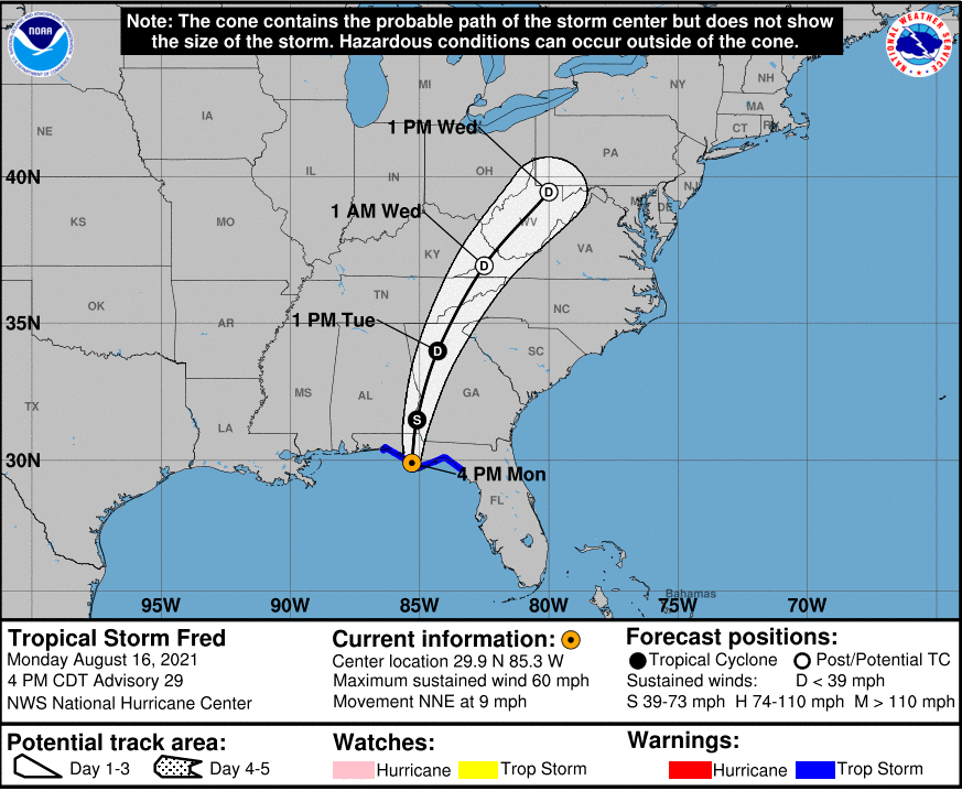
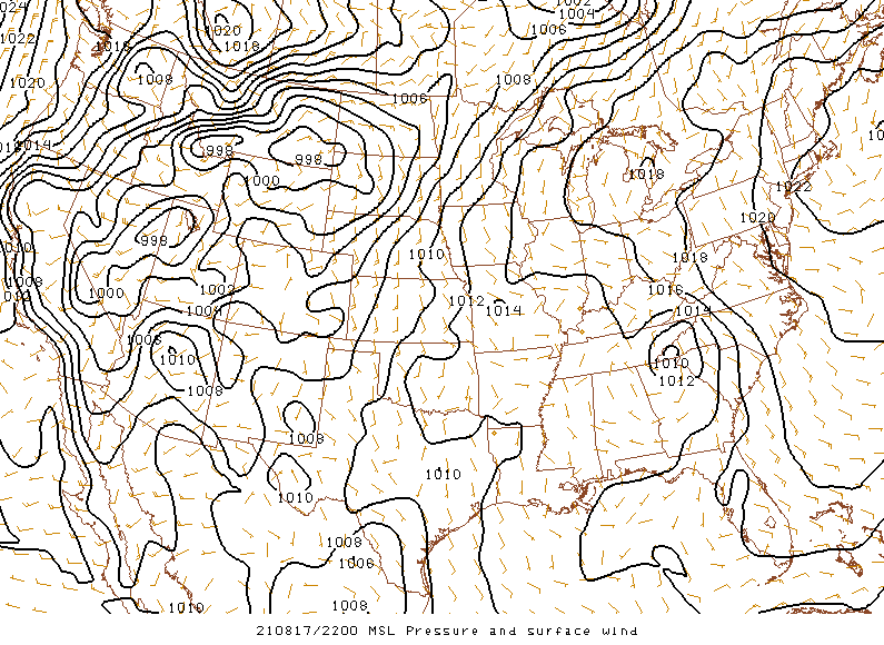
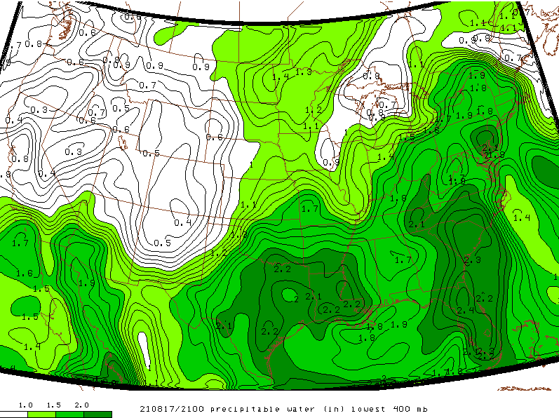
As Tropical Storm Fred made landfall on Monday August 16 in the Florida panhandle, it moved in a north to northeastward path through the southern Appalachians while weakening to a depression during the day Tuesday August 17 as shown by the Three Day Cone from the National Hurricane Center valid for 4 PM CDT Monday which was around the time of landfall. As Fred moved north to northeastward toward the region, it's surface pressure continued to increase (weaken) with a minimum central pressure contour of only 1012 mb over northern Georgia and southwest North Carolina Tuesday afternoon. However, deep southerly to southeasterly flow ahead of the remnant circulation advected copious amounts of moisture from the Gulf of America and western Atlantic into the southern Appalachians as seen by impressive 850 mb moisture transport and theta e advection taking place Tuesday afternoon. This deep moisture advection combined with the warm core of the tropical system led to a classic environment for warm rain processes. This is shown well by the 12Z (8 AM EDT) observed sounding from Greensboro, North Carolina which depicted freezing levels above 14 thousand feet and LCL heights below 580 meters leading to a deep, warm cloud layer with long, skinny CAPE. This along with precipitable water values increasing to over 2 inches led to highly efficient rainfall rates. Due to the track of the remnant circulation up the spine of the Appalachians, the heaviest and most persistent rainfall occurred from southwest North Carolina and southeast Tennessee along the mountains through northeast Tennessee and southwest Virginia. Lesser amounts fell toward the Plateau since that area was farther removed from the strongest moisture advection.
 |
 |
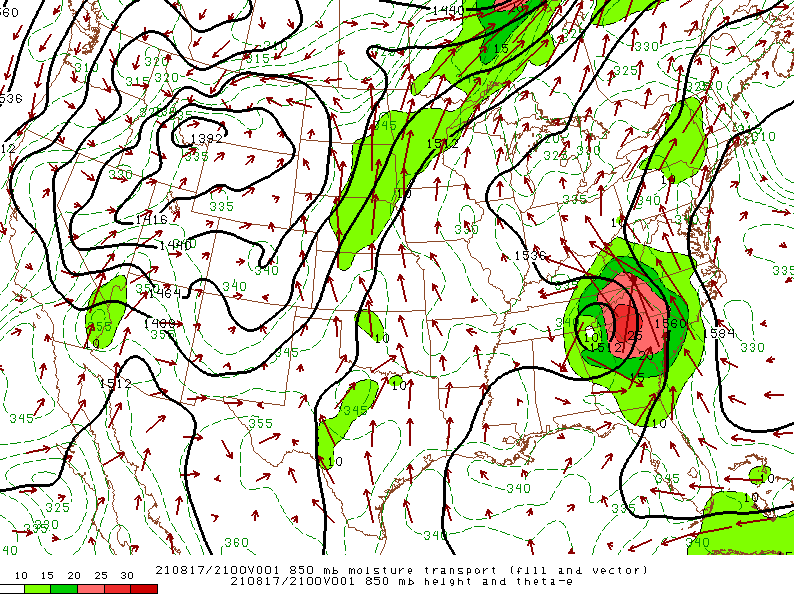 |
| Figure 1: Three Day Forecast Cone From NHC | Figure 2: Mean Sea Level Pressure (MSLP) | Figure 3: 850 mb Moisture Transport |
 |
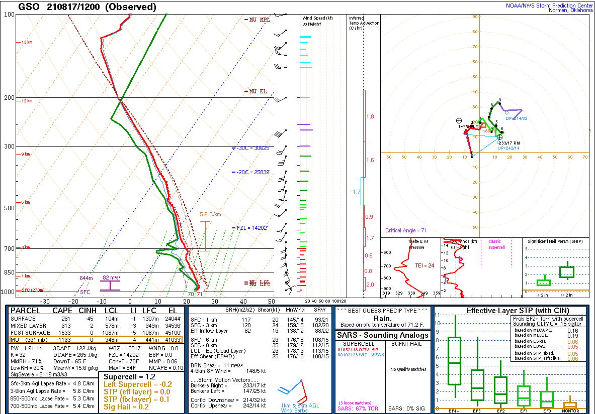 |
| Figure 4: Precipitable Water | Figure 5: 12Z Aug 17 Greensboro, NC Observed Sounding |
 |
Media use of NWS Web News Stories is encouraged! Please acknowledge the NWS as the source of any news information accessed from this site. |
 |